|
Author
United States. Post Office Department
Full Title
Post Route Map of the State of Ohio.
List No
15918.002
Author
Burr, David H., 1803-1875
Full Title
Map of the northern parts of Ohio, Indiana and Illinois with Michigan and that part of the Ouisconsin territory lying east of the Mississippi River
List No
15634.000
Author
[Brown, Constance, Widmer, Ted]
Full Title
Lincoln's Odyssey. "to travel sea and land, as fast as wind." Hom Od. 1:99
List No
15608.000
Note
This map was a collaboration between author Ted Widmer and Connie Brown to create map end papers for Widmer's Book "Lincoln on the Verge: Thirteen Days to Washington," published in 2020.
Author
Cram, George Franklin, 1841-1928
Full Title
(Composite Map to) Ohio : North half. -- Ohio : [South half]. 1899, by Geo. F. Cram.
List No
14372.067
Note
Composite map of Ohio (northern and southern halves). Shows political boundaries, counties, towns, railroads, steamship lines, topography, bodies of water, drainage, coastlines and islands. Relief shown with hachures. Includes keys with explanations, latitudinal and longitudinal lines, as well as bar scales given in miles. With alphanumeric grid corresponding to "Index of Ohio" on pages 111-113, 116-119, 122-125 and 128. Colored lithograph. Together, maps are 80 x 55 cm, on two double sheets 90 x 67 cm. "Index of maps" and "Index of cities" in margins, providing navigation for atlas as a whole.
Author
Tanner, Henry Schenck, 1786-1858
Full Title
Ohio And Indiana. By H.S. Tanner. Engraved & Published by H.S. Tanner, Philadelphia. Entered ... 24th day of May 1819, by Tanner, Vallance, Kearny & Co. ... Pennsylvania.
List No
2939.002
Author
Ensign & Thayer
Full Title
Pictorial Map of the Great West.
List No
15332.000
Author
[Fisher, Joseph R., Planters Peanuts (Firm)]
Full Title
Colorado : The centennial state -- Nebraska : The cornhusker state -- West Virginia : The mountain state -- Ohio : The buckeye state.
List No
14374.008
Note
Four views, representing Colorado, Nebraska, West Virginia and Ohio. Views show examples of the landscape and natural resources. Each view includes an inset map of the state, which marks the location of the capital city with a star. Accompanied by descriptive text, the state flags, seals and flowers: columbine, goldenrod, big rhododendron and scarlet carnation, respectively. The view of each state appears both in color (on top) and in black and white (bottom), the latter inviting coloration. Together, views are 18 x 52 cm, on two sheets 20 x 54 cm.
Author
Burr, David H., 1803-1875
Full Title
Ohio. Drawn and published by David H. Burr. New-York.
List No
14341.004
Note
Map of Ohio and vicinity. Shows political boundaries, cities, roads, canals, water routes, drainage, shorelines and islands. Features the Seneca Indian Reservation, in Seneca County. Includes a bar scale, given in American miles, as well as latitudinal and longitudinal lines. Hand-colored engraving. Map is 25 x 30 cm, on sheet 35 x 43 cm. "Entered according to act of Congress in the year 1831 by David H. Burr, in the Clerk's office of the District Court for the Southern District of New-York."
Author
Cram, George Franklin, 1841-1928
Full Title
Railroad and county map of Ohio. Geo. F. Cram, engraver and publisher, Chicago. 1882.
List No
14250.007
Note
Map of Ohio, showing railroads (both finished and unfinished), county boundaries, cities and towns, post offices, drainage and coastline. Political boundary lines in color. Includes a legend and a bar scale. With index numbers along the perimeter, and decorative border. 43 x 57 cm, on sheet 45 x 58.
Author
Lackawanna Railroad
Full Title
Lackawanna Railroad. The Road of Anthracite. Through Car Routes New York to Chicago.
List No
10610.003
Author
Larrance, Isaac, 1804-1896
Full Title
Counties in Ohio. (to accompany) Larrance's Post office chart, and maps of ten states ... By Isaac Larrance. Cincinnati : Printed and for sale by I. A. Pittman. 1866.
List No
11666.006
Note
Color map of the Ohio counties. Shows county boundaries, towns and railroads.
Author
Appleton, D. & Co.
Full Title
Map of Ohio. Copyright 1891 by Matthews-Northrup Co. ... Buffalo, New York. (to accompany) The Library Atlas Of Modern Geography ... New York, D. Appleton And Company 1892. (on upper margin) Ohio. 90.
List No
0026.233
Note
Color map. Shows county boundaries and county seat, capital, railways, roads, rivers, etc. "Size of type indicates importance of the places". Includes notes. Prime meridians are Greenwich and Washington.
Author
Appleton, D. & Co.
Full Title
Map of Cleveland, Ohio. Copyright 1891 by Matthews-Northrup Co. ... Buffalo, New York. (to accompany) The Library Atlas Of Modern Geography ... New York, D. Appleton And Company 1892. (on upper margin) Cleveland. 91.
List No
0026.236
Note
Color plan. Shows railways, street car lines, city blocks, parks, etc. Includes numerical references to depots, hotels, churches, major buildings, and points of interest.
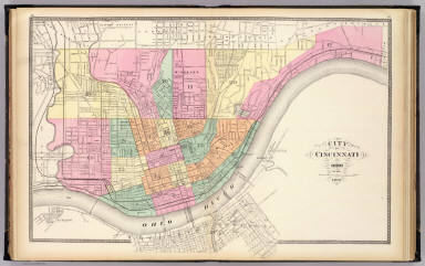
Author
Appleton, D. & Co.
Full Title
Map of Cincinnati, Ohio. Copyright 1891 by Matthews-Northrup Co. ... Buffalo, New York. (to accompany) The Library Atlas Of Modern Geography ... New York, D. Appleton And Company 1892. (on upper margin) Cincinnati. 92.
List No
0026.237
Note
Color plan. Shows railways, street car lines, city blocks, parks, etc. Includes numerical references to depots, hotels, churches, major buildings, and points of interest.
Author
Arbuckle Bros.
Full Title
North Carolina, Connecticut, West Virginia, Ohio. Copyright 1889 Arbuckle Bros. N.Y.
List No
0027.008
Note
Sheet with maps of four states in full color. West Virginia is known as a tourist destination because of its beautiful mountain scenery. It is also noted for its principal products including coal oil, or kerosene. It is noted that in Connecticut "the ingenuity or wideawakedness of her people is so great as to have become proverbial." It is stated that in Ohio education is universal. Each card measures 7.5 x 12.5 cm.
Full Title
Ohio. (Boston: Published by Thomas & Andrews. 1812)
List No
0028.048
Note
Engraved map, uncolored. Relief shown by hachures. Shows the Seven ranges, Army lands, Virginia donation, settlements, rivers, etc. Prime meridians: Philadelphia and London. The names of Lewis and the engraver Alexander Lawson have been erased.
Author
Asher & Adams
Full Title
Asher & Adams' Ohio & Indiana. Entered according to Act of Congress in the year 1874 by Asher & Adams ... at Washington. (New York, 1874)
List No
0041.019
Note
Hand col. engraved map. Shows townships, distances along railroads, etc. Prime meridians: Greenwich and Washington.
Author
[Bartholomew, John, Black, Adam & Charles]
Full Title
Ohio, Indiana & Illinois. Published by A. & C. Black. Edinburgh. Printed in Colours by Schenck & Macfariane. Edinburgh. Drawn & Engraved by J. Bartholomew, Edinburgh.
List No
0073.008
Note
States outlined in color. Land tinted.
Author
[Bourne, A., Kilbourne, J., Reed, Abner]
Full Title
Map Of The State Of Ohio. Drawn by A. Bourne. Including the Indian Reservations, Purchased and laid out into Counties and Townships in 1820, Drawn by J. Kilbourne. Engraved by A. Reed.
List No
0086.000
Note
Published in: Caleb Atwater, "Description of the antiquities discovered in the state of Ohio," Archaeologica Americana, Vol 1, 1820 (see our #3387). An excellent, very early map showing the absorption of Indian land in the northwest for settlement. Engraved by Abner Reed of East Windsor, Connecticut. Bourne and Hough did a larger Ohio map in 1815. Color map, showing rivers, roads, vegetation, and place names. Relief shown by shadings and hachures.
Author
Bradford, Thomas G.
Full Title
Washington. Louisville and Jeffersonville. New Orleans. Cincinnati. Entered ... 1838, by T.G. Bradford ... Massachusetts.
List No
0089.006
Note
Four city maps in full color. The map of Washington includes numbered locations including the Capitol, the State Department, Departments of War, Navy, and the Treasury, as well as the General Post Office.
Author
Bradford, Thomas G.
Full Title
Ohio. Entered ... 1838, by T.G. Bradford ... Massachusetts.
List No
0089.018
Note
In full color.
Full Title
Carte geographique, statistique et historique de l'Ohio. Ohio. Fonderie et Imprimerie de J. Carez. (1825)
List No
0102.026
Note
Hand colored engraved map. Relief shown by hachures. Text and tables at sides and bottom. Prime meridians: Washington and Paris.
Author
Burr, David H., 1803-1875
Full Title
Map of Ohio And Indiana Exhibiting the Post Offices, Post Roads, Canals, Rail Roads, &c. By David H. Burr. (Late Topographer to the Post Office.) Geographer to the House of Representatives of the U.S. John Arrowsmith. Entered ... July 10th, 1839, by David H. Burr ... District of Columbia.
List No
0104.010
Note
In full color by county. Postal routes by coach, stage, sulkey, cross, rail roads and canals shown. In 8 sections mounted on linen. Label on back states "No. 10. Ohio, Indiana."
Author
Burr, David H.
Full Title
Ohio. By David H. Burr. Published By J.H. Matheer & Co. Hartford. 1846. Entered ... 1833 by J.H. Colton & Co. ... New York. Engraved & Printed by S. Stiles & Co. (inset) Cincinnati.
List No
0107.000
Note
Last edition, first was 1833; this was the only edition published by Mather. This came from the Minnesota Historical Society collection. Full color by county. Colton published all the earlier editions. See our #3161 for the 1836 edition published by Colton. Explanatory remarks showing towns, roads, canals and railroads. Prime meridians are Greenwich and Washington, D.C.
Author
[Carey, H. C., Lea, I.]
Full Title
Geographical, Historical, And Statistical Map Of Ohio. Ohio. No. 26. Drawn by F. Lucas Jr. Boyd sc.
List No
0122.021
Note
In full color by county surrounded by text.
Author
Colton, G.W.
Full Title
Ohio. (with) Vicinity Of Cleveland Cuyahoga Co. Published By J.H. Colton & Co. No. 172 William St. New York. Entered ... 1855 by J.H. Colton & Co. ... New York. No. 39.
List No
0149.044
Note
In full color by county.
Author
Colton, G.W.
Full Title
The Cities Of Pittsburgh And Allegheny, With Parts Of Adjacent Boroughs, Pennsylvania. (with) The City Of Cincinnati Ohio. Published By J.H. Colton & Co. No. 172 William St. New York. Entered ... 1855 by J.H. Colton & Co. ... New York. No. 40.
List No
0149.045
Note
In full color by region of the city. A single border encloses the two separate maps.
Author
Colton, G.W.
Full Title
Colton's Ohio. (inset) Vicinity of Cleveland, Cuyahoga Co. Published By J. H. Colton. No. 172 William St. New York.
List No
0151.050
Note
Map showing the county boundaries in color. Prime meridians are Greenwich and Washington D.C.
Author
Colton, G.W.
Full Title
Colton's Ohio. (inset) Vicinity of Cleveland, Cuyahoga Co. Published By G. W & C. B. Colton & Co. No. 172 William St. New York.
List No
0152.049
Note
Prime meridians are Washington D.C. and Greenwich.
Author
Colton, G.W.
Full Title
The Cities of Pittsburgh and Allegheny with Part of Adjacent Boroughs Pennsylvania. The City of Cincinnati, Ohio. Published By G. W & C. B. Colton & Co. No. 172 William St. New York.
List No
0152.050
Note
The maps of Cincinnati & Pittsburgh are drawn upon the same scale.
Author
Colton, G.W. & C.B.
Full Title
(Covers to) Colton's Railroad & Township Map of the State of Ohio. Published By G.W. & C.B. Colton, No. 172 William St. New York. 1867. Entered ... 1851 by J.H. Colton ... New York.
List No
0157.001
Note
As with all issues of this map, the primary difference between editions is the rapid railroad growth in the state. Full color by township. Map is folded into dark brown cloth covers 14.5x9 with "Colton's Township Map Of The State Of Ohio G.W. & C.B. Colton & Co." in gilt. Prime meridians are Greenwich and Washington D.C.
Author
Colton, G.W. & C.B.
Full Title
Colton's Railroad & Township Map of the State of Ohio. Published By G.W. & C.B. Colton, No. 172 William St. New York. 1867. Entered ... 1851 by J.H. Colton ... New York.
List No
0157.002
Note
As with all issues of this map, the primary difference between editions is the rapid railroad growth in the state. Full color by township. Map is folded into dark brown cloth covers 14.5x9 with "Colton's Township Map Of The State Of Ohio G.W. & C.B. Colton & Co." in gilt. Prime meridians are Greenwich and Washington D.C.
Author
Colton, J.H.
Full Title
(Covers to) Colton's Railroad & Township Map of the State of Ohio. Published By J.H. Colton No. 49 Cedar St. New York. 1853. Entered ... 1851 by J.H. Colton ... New York. Drawn by George W. Colton. Engraved by J.M. Atwood, New York.
List No
0175.001
Note
Second edition. This was one of Colton's most popular pocket maps, with Karrow showing almost annual editions to 1883. All editions have a large vignette of the state capital under the title. Full color by county, folded into stamped mauve cloth covers 14.5x9 with "Township Map Of The State Of Ohio Published By J.H. Colton" in gilt. Prime meridians are Greenwich and Washington D.C.
Author
Colton, J.H.
Full Title
Colton's Railroad & Township Map of the State of Ohio. Published By J.H. Colton No. 49 Cedar St. New York. 1853. Entered ... 1851 by J.H. Colton ... New York. Drawn by George W. Colton. Engraved by J.M. Atwood, New York.
List No
0175.002
Note
Second edition. This was one of Colton's most popular pocket maps, with Karrow showing almost annual editions to 1883. All editions have a large vignette of the state capital under the title. Full color by county, folded into stamped mauve cloth covers 14.5x9 with "Township Map Of The State Of Ohio Published By J.H. Colton" in gilt. Prime meridians are Greenwich and Washington D.C.
Author
Colton, J.H.
Full Title
(Covers to) Colton's Map Of The Oil District Of West Virginia And Ohio. Published By J.H. Colton 172 William St. N.Y. 1865. Second Edition. Entered ... 1864 by J.H. Colton ... New York.
List No
0186.001
Note
This is a large scale map with good detail on the oil discoveries on the Little Kanawha River in West Virginia and Buck Creek in Ohio. It has an unusual look for a Colton map, indicating it may have been drawn by someone outside the Colton firm. Streeter and Phillips list a first edition in 1865. Full color by township. Folded into patterned brown cloth covers 16x10 with "Colton's Map Of The Oil District Of Ohio And West Virginia J.H. Colton. New York." in gilt.
Author
Colton, J.H.
Full Title
Colton's Map Of The Oil District Of West Virginia And Ohio. Published By J.H. Colton 172 William St. N.Y. 1865. Second Edition. Entered ... 1864 by J.H. Colton ... New York.
List No
0186.002
Note
This is a large scale map with good detail on the oil discoveries on the Little Kanawha River in West Virginia and Buck Creek in Ohio. It has an unusual look for a Colton map, indicating it may have been drawn by someone outside the Colton firm. Streeter and Phillips list a first edition in 1865. Full color by township. Folded into patterned brown cloth covers 16x10 with "Colton's Map Of The Oil District Of Ohio And West Virginia J.H. Colton. New York." in gilt.
Author
Cram, George Franklin
Full Title
Ohio.
List No
0210.038
Note
Prime meridians Greenwich and Washington.
Full Title
The state of Ohio with part of Upper Canada, &c. (Philadelphia: Robert DeSilver, 1827)
List No
0241.000
Note
Reissue from M. Carey's 1818 edition General Atlas. No changes from the 1818 edition. Outline color by county. Shows counties, settlements, roads, etc. Prime meridians: London and Philadelphia. "24."
Author
[Chapin, Gardner S., Rand McNally and Company, Schumacher, Arthur H.]
Full Title
Photo-auto maps (list. Compiled by Gardner S. Chapin and Arthur H. Schumacher. Copyright, 1907, by G.S. Chapin, Chicago. Published by the Motor Car Supply Co. ... The Automobile Supply Co. ... Chicago, Ill.)
List No
0268D
Note
List of maps in the Chicago, Detroit, Toledo and Cleveland divisions.
Author
Finley, Anthony
Full Title
Map of the States Of Ohio Indiana & Illinois And Part Of Michigan Territory Compiled from the Latest Authorities. D.H. Vance Del. J.H. Young Sc. Philada. Published by A. Finley 1825.
List No
0278.011
Note
In full color by county or region of the state. Statistical information includes mileage, population broken down by White Males, White Females, Free People of Colour, Slaves and Militia.
Author
Finley, Anthony
Full Title
Map of the States of Ohio, Indiana & Illinois and Part of the Michigan Territory, Complied from the Latest Athorities.
List No
0279.015
Author
Finley, Anthony
Full Title
Map of the States of Ohio, Indiana, & Illinois, and Part of the Michigan Territory, Compiled from the Latest Authorities. D.H. Vance Del., Philada. Published by A. Finley 1827. J.H. Young Sc.
List No
0280.011
Note
Relief shown by hachures. Prime meridian Washington. Statistical table for each state.
Author
Finley, Anthony
Full Title
Ohio. Young & Delleker Sc. Published by A. Finley, Philada. (to accompany) A New General Atlas Comprising a Complete Set of Maps, representing the Grand Divisions Of The Globe ... Philadelphia: Published by Anthony Finley. 1827.
List No
0282.027
Note
Full color map on sheet 35x27. Prime meridians are Washington and Greenwich. Shows counties, major cities, roads and rivers.
Author
Finley, Anthony
Full Title
Ohio. Published by A. Finley Philada. Young & Delleker Sc.
List No
0285.023
Note
Full color by county.
Author
Gray, O.W.
Full Title
Gray's Atlas Map of Ohio. (inset) Vicinity of Cincinnati.
List No
0310.059
Author
[Gray, Frank A., Gray, O.W.]
Full Title
Gray's New Map of Ohio by Frank A. Gray. Copyright 1877 by O.W. Gray & Son. (insets) Physical Map of Ohio. Historical Map of Ohio. Vicinity of Cleveland. Vicinity of Toledo. City of Columbus. Vicinity of Cincinnati.
List No
0312.035
Author
Caughey, R.
Full Title
Factories of the Peck, Stow & Wilcox Co., manufacturers of tinsmiths' tools and machines, mechanics' tools, meat cutters and general hardware. Main office, Southington, Conn. ... (Drawn by) Caughey. (D.H. Hurd & Co., Boston, 1893)
List No
0332.020
Note
Five b&w illustrations on 1 sheet. Contents: The Peck, Stow & Wilcox Co., Southington, Conn., U.S.A. -- The Peck, Stow & Wilcox Co., Cleveland, Ohio -- The Peck, Stow & Wilcox Co., Plantsville, Conn. -- The Peck, Stow & Wilcox Co. edge tool works, Southington, Conn. -- The Peck, Stow & Wilcox Co. manufactures tinmans' tools, compasses, etc., East Berlin, Conn.
Author
Johnson, A.J.
Full Title
Johnson's Ohio, Published By Johnson and Ward. Entered ... 1864, by A.J. Johnson ... New York.
List No
0352.035
Note
Full color by county, with heavy outlines around the state. Shows railroads, roads, and canals. Includes vignette of the State Capital at Columbus. Prime meridians are Greenwich and Washington D.C.
Author
Johnson, A.J.
Full Title
Johnson's Ohio. Entered ... 1864.
List No
0358.040
Author
Leahy, J.F.
Full Title
(Index to) Leahy's Hotel Guide and Railway Distance Maps. Ohio.
List No
0425.094
Note
Alphabetical index list of the Hotels of the town with the number of rooms of each, their rates per day and the population of the town. Includes population of the state, and Explanation of abbreviation of the railroad of the state.
Author
Leahy, J.F.
Full Title
Leahy's Hotel Guide and Railway Distance Map of the State of Ohio. Published by American Hotel Register Company. Leahy Build., 228-234 W. Ontario St., Chicago, Ill. Copyrighted by J.F. Leahy, Jan., 1934.
List No
0425.095
Note
Map printed without color. Includes name of the railroad entering the town, and distance between towns.
Author
Leahy, J.F.
Full Title
(Index to) Leahy's Hotel Guide and Railway Distance Maps. Ohio.
List No
0425.096
Note
Alphabetical index list of the Hotels of the town with the number of rooms of each, their rates per day and the population of the town. Includes population of the state, and Explanation of abbreviation of the railroad of the state.
Author
Leahy, J.F.
Full Title
Leahy's Hotel Guide and Railway Distance Map of the State of Ohio. Published by American Hotel Register Company. Leahy Build., 228-234 W. Ontario St., Chicago, Ill. Copyrighted by J.F. Leahy, Jan., 1934.
List No
0425.097
Note
Map printed without color. Includes name of the railroad entering the town, and distance between towns.
Author
[Lawrence, Martin, Washington, George]
Full Title
West Virginia and Ohio, showing in red the places visited by George Washington and the routes of his Ohio River journey in 1770, and his journey across West Virginia in 1784.
List No
0465.035
Note
Color map. Showing locality known and approximate.
Author
[Mitchell, Samuel Augustus, Young, James H.]
Full Title
(Covers to) The Tourist's Pocket Map Of The State Of Ohio Exhibiting Its Internal Improvements Roads Distances &c. By J.H. Young. Philadelphia: Published By S. Augustus Mitchell. 1833. Entered ... April 15th 1831 by S. Augustus Mitchell ... Pennsylvania. D. Haines Sc.
List No
0512.001
Note
1st issue was 1831. Ohio was one of the earliest Tourist pocket maps. Folded into red leather covers 12x7.5 with "Mitchell's Map Of Ohio" and a decorative border in gilt. Full color.
Author
[Mitchell, Samuel Augustus, Young, James H.]
Full Title
The Tourist's Pocket Map Of The State Of Ohio Exhibiting Its Internal Improvements Roads Distances &c. By J.H. Young. Philadelphia: Published By S. Augustus Mitchell. 1833. Entered ... April 15th 1831 by S. Augustus Mitchell ... Pennsylvania. D. Haines Sc.
List No
0512.002
Note
1st issue was 1831. Ohio was one of the earliest Tourist pocket maps. Folded into red leather covers 12x7.5 with "Mitchell's Map Of Ohio" and a decorative border in gilt. Full color.
Author
Mitchell, Samuel Augustus
Full Title
(Covers to) Map of the States Of Ohio, Indiana And Illinois with the settled part of Michigan. Published by S. Augustus Mitchell Philadelphia: 1834. Sold by Mitchell & Hinman No. 6 North 5th St. Entered ... 1834 by S. Augustus Mitchell ... Pennsylvania. Engraved by J.H. Young. (inset) Lead Region East of the Mississippi River. (inset) Falls Of Ohio. (inset) Vicinity Of Cincinnati. (inset) Vicinity Of Detroit.
List No
0514.001
Note
Updated version of Finley American Atlas map of 1825; changes from the 1831 Mitchell issue include the four inset maps, moving the title to the lower right, a table of Steamboat Routes, and new counties throughout. Folded into dark green leather covers 13.5x8 with "Mitchell's Map Of Ohio, Indiana, Illinois & Michigan." and a decorative border stamped in gilt. Full color. Prime meridian is Washington D.C.
Author
Mitchell, Samuel Augustus
Full Title
Map of the States Of Ohio, Indiana And Illinois with the settled part of Michigan. Published by S. Augustus Mitchell Philadelphia: 1834. Sold by Mitchell & Hinman No. 6 North 5th St. Entered ... 1834 by S. Augustus Mitchell ... Pennsylvania. Engraved by J.H. Young. (inset) Lead Region East of the Mississippi River. (inset) Falls Of Ohio. (inset) Vicinity Of Cincinnati. (inset) Vicinity Of Detroit.
List No
0514.002
Note
Updated version of Finley American Atlas map of 1825; changes from the 1831 Mitchell issue include the four inset maps, moving the title to the lower right, a table of Steamboat Routes, and new counties throughout. Folded into dark green leather covers 13.5x8 with "Mitchell's Map Of Ohio, Indiana, Illinois & Michigan." and a decorative border stamped in gilt. Full color. Prime meridian is Washington D.C.
Author
Johnson, A.J.
Full Title
Johnson's Ohio, Published By Johnson and Ward.
List No
0535.033
Note
In full color by county. Vignette of the State Capitol at Columbus. Relief shown by hachures. Meridians Greenwich and Washington D.C.
Author
Mitchell, Samuel Augustus
Full Title
A New Map Of Ohio with its Canals Roads And Distances. (with) Cincinnati. Published By S. Augustus Mitchell, N.E. corner of Market & 7th Street Philada., 1846. Entered ... 1846 by H.N. Burroughs ... Pennsylvania.
List No
0537.029
Note
In full color by county with steamboat route distances shown. Profile of the Ohio Canal included.
Author
Mitchell, Samuel Augustus
Full Title
A New Map of Ohio with its Canals, Roads & Distances. Published By S. Augustus Mitchell. N.E. corner of Market & 7th. Streets. Philadelphia. (inset) Profile of the Ohio Canal.
List No
0545.032
Note
Full color map. Includes explanation chart, and reference to steam boat routes. Prime meridian is Washington D.C. Relief shown by hachures.
Author
[Mitchell, Samuel Augustus, Young, James H.]
Full Title
(Covers to) The Tourist's Pocket Map Of The State Of Ohio Exhibiting Its Internal Improvements Roads Distances &c. By J.H. Young. Philadelphia: Published By Thomas, Cowperthwait & Co. 1851. Sold by Thomas, Cowperthwait & Co. No. 253 Market Street. Entered ... April 15th 1831 by S. Augustus Mitchell ... Pennsylvania. (inset) Profile of the Ohio and Erie Canal. (inset) Profile of the Miami Canal.
List No
0551.001
Note
Late edition, lithographed. In the transfer to lithography, the image was slightly enlarged (compare dimensions and scale to the engraved 1833 edition). Map is folded into stamped black leather covers 12.5x8 with "Mitchell's Map Of Ohio" in gilt. Full color. Prime meridians are Washington D.C. and Greenwich.
Author
[Mitchell, Samuel Augustus, Young, James H.]
Full Title
The Tourist's Pocket Map Of The State Of Ohio Exhibiting Its Internal Improvements Roads Distances &c. By J.H. Young. Philadelphia: Published By Thomas, Cowperthwait & Co. 1851. Sold by Thomas, Cowperthwait & Co. No. 253 Market Street. Entered ... April 15th 1831 by S. Augustus Mitchell ... Pennsylvania. (inset) Profile of the Ohio and Erie Canal. (inset) Profile of the Miami Canal.
List No
0551.002
Note
Late edition, lithographed. In the transfer to lithography, the image was slightly enlarged (compare dimensions and scale to the engraved 1833 edition). Map is folded into stamped black leather covers 12.5x8 with "Mitchell's Map Of Ohio" in gilt. Full color. Prime meridians are Washington D.C. and Greenwich.
Author
Mitchell, Samuel Augustus
Full Title
County Map Of Ohio, And Indiana. 31. Entered ... 1860, by S. Augustus Mitchell, Jr. ... Pennsylvania.
List No
0565.021
Note
In full color by county.
Author
Mitchell, Samuel Augustus
Full Title
Plan Of Cincinnati And Vicinity. 32. Entered ... 1860, by S. Augustus Mitchell, Jr. ... Pennsylvania.
List No
0565.022
Note
Full color by numbered area.
Author
Mitchell, Samuel Augustus Jr.
Full Title
County map of Ohio and Indiana. Drawn & Engraved by W.H. Gamble Philad. Entered ... 1863 by S. Augustus Mitchell, Jr. ... Pennsylvania.
List No
0572.031
Note
Full color map by county. Prime meridians are Greenwich and Washington, D.C.
Author
Mitchell, Samuel Augustus Jr.
Full Title
Plan of Cincinnati and Vicinity. Entered ... 1860 by S. Augustus Mitchell, Jr. ... Pennsylvania.
List No
0572.032
Note
Full color map.
Author
Mitchell, Samuel Augustus Jr.
Full Title
County map of Ohio and Indiana. Drawn and Engraved by W.H. Gamble Phila. Entered ... 1867 by S. Augustus Mitchell, Jr. ... Pennsylvania.
List No
0579.032
Note
Color map by county. Prime meridians are Greenwich and Washington, D.C.
Author
Mitchell, Samuel Augustus Jr.
Full Title
Plan of Cincinnati and Vicinity. Entered ... 1867 by S. Augustus Mitchell, Jr. ... Pennsylvania.
List No
0579.033
Note
Color map. Showing roads, railroads, etc.
Author
Mitchell, Samuel Augustus
Full Title
County & township map of the states of Ohio and Indiana. Entered ... 1879 by S. Augustus Mitchell ... Washington. (1880)
List No
0586.030
Note
Hand colored. Shows settlements, railroads, rivers, etc. Includes diagram showing arrangement of sections within a township. Prime meridians: Greenwich and Washington.
Author
Mitchell, Samuel Augustus
Full Title
Plan of Cincinnati and vicinity. Entered ... 1879 by S. Augustus Mitchell ... Washington. (1880)
List No
0586.031
Note
Hand colored. Shows wards, major buildings, railroads, etc.
Author
Mitchell, Samuel Augustus Jr.
Full Title
County & township map of the states (sic) of Ohio and (sic). Copyright by S. Augustus Mitchell 1884.
List No
0592.032
Note
Hand colored. Shows settlements, railroads, rivers, etc. Includes diagram showing arrangement of sections within a township. Prime meridians: Greenwich and Washington.
Author
Mitchell, Samuel Augustus Jr.
Full Title
Plan of Cincinnati and vicinity. Copyright by S. Augustus Mitchell 1884.
List No
0592.034
Note
Hand colored. Shows wards, major buildings, railroads, etc.
Full Title
County & township map of the states (sic) of Ohio and (sic). Copyright 1887 by Wm. M. Bradley & Bro. (1890)
List No
0594.031
Note
Hand colored. Shows settlements, railroads, rivers, etc. Includes diagram showing arrangement of sections within a township. Prime meridians: Greenwich and Washington.
Full Title
Plan of Cincinnati and vicinity. Copyright 1887 by Wm. M. Bradley & Bro. (1890)
List No
0594.033
Note
Hand colored. Shows wards, major buildings, railroads, etc.
Author
[Morse, Charles W., Colby, Charles A.]
Full Title
Ohio.
List No
0623.033
Author
Rand McNally and Company
Full Title
(Covers to) Ohio. Rand McNally & Co., Map Publishers and Engravers, Chicago, 1911. Rand, McNally & Co.'s New Business Atlas Map of Ohio. Copyright, 1911, ... 1902 ... (inset) Map Of Hamilton Co., Ohio. (with 110 page index) The Rand-McNally Indexed County And Railroad Pocket Map And Shippers' Guide Of Ohio ... Chicago And New York: Rand, McNally & Co. ... (on verso) Copyright, 1911, Rand, McNally & Co., Chicago.
List No
0789.001
Note
Full printed color by county. Map is folded into tan card board covers 17x10.5 with same title as index, but publisher information is given as "Rand McNally & Company, Chicago, New York, Los Angeles." Includes index to Ohio Chief Cities and the list of Ohio Railroads. The numbers in the list correspond to the numbers on the map.
Author
Rand McNally and Company
Full Title
(Title Page to) Ohio. Rand McNally & Co., Map Publishers and Engravers, Chicago, 1911. Rand, McNally & Co.'s New Business Atlas Map of Ohio. Copyright, 1911, ... 1902 ... (inset) Map Of Hamilton Co., Ohio. (with 110 page index) The Rand-McNally Indexed County And Railroad Pocket Map And Shippers' Guide Of Ohio ... Chicago And New York: Rand, McNally & Co. ... (on verso) Copyright, 1911, Rand, McNally & Co., Chicago.
List No
0789.002
Note
Full printed color by county. Map is folded into tan card board covers 17x10.5 with same title as index, but publisher information is given as "Rand McNally & Company, Chicago, New York, Los Angeles." Includes index to Ohio Chief Cities and the list of Ohio Railroads. The numbers in the list correspond to the numbers on the map.
Author
Rand McNally and Company
Full Title
Ohio. Rand McNally & Co., Map Publishers and Engravers, Chicago, 1911. Rand, McNally & Co.'s New Business Atlas Map of Ohio. Copyright, 1911, ... 1902 ... (inset) Map Of Hamilton Co., Ohio. (with 110 page index) The Rand-McNally Indexed County And Railroad Pocket Map And Shippers' Guide Of Ohio ... Chicago And New York: Rand, McNally & Co. ... (on verso) Copyright, 1911, Rand, McNally & Co., Chicago.
List No
0789.003
Note
Full printed color by county. Map is folded into tan card board covers 17x10.5 with same title as index, but publisher information is given as "Rand McNally & Company, Chicago, New York, Los Angeles." Includes index to Ohio Chief Cities and the list of Ohio Railroads. The numbers in the list correspond to the numbers on the map.
Author
[Rand McNally and Company, Whitely, William N. Co.]
Full Title
(Covers to) Whitely's Centennial Pocket Map Of Ohio. Whitely's New Steel Mower. Springfield, Ohio. Rand, McNally & Co.'s Business Atlas Map of Ohio. Copyright, 1888, by Rand, McNally & Co.
List No
0827.001
Note
Fine illustrations of Whitely's Mowing Machines. Map is from Rand McNally's Business Atlas. Full printed color by county. Folded into white card board covers 14x9.5 printed with "Whitely's Centennial Pocket Map Of the Great State of Ohio. 1788 - 1888. Published By The William N. Whitely Company, Springfield, Ohio."
Author
[Rand McNally and Company, Whitely, William N. Co.]
Full Title
Whitely's Centennial Pocket Map Of Ohio. Whitely's New Steel Mower. Springfield, Ohio. Rand, McNally & Co.'s Business Atlas Map of Ohio. Copyright, 1888, by Rand, McNally & Co.
List No
0827.002
Note
Fine illustrations of Whitely's Mowing Machines. Map is from Rand McNally's Business Atlas. Full printed color by county. Folded into white card board covers 14x9.5 printed with "Whitely's Centennial Pocket Map Of the Great State of Ohio. 1788 - 1888. Published By The William N. Whitely Company, Springfield, Ohio."
Author
[Rand McNally and Company, Whitely, William N. Co.]
Full Title
Whitely's Centennial Pocket Map Of Ohio. Whitely's New Steel Mower. Springfield, Ohio. Rand, McNally & Co.'s Business Atlas Map of Ohio. Copyright, 1888, by Rand, McNally & Co.
List No
0827.003
Note
Fine illustrations of Whitely's Mowing Machines. Map is from Rand McNally's Business Atlas. Full printed color by county. Folded into white card board covers 14x9.5 printed with "Whitely's Centennial Pocket Map Of the Great State of Ohio. 1788 - 1888. Published By The William N. Whitely Company, Springfield, Ohio." (on verso) Illustrations of Whitely's Solid Steel Mower and binder, 1889...
Author
[Scovel, James L., O'Brien, Emmett J]
Full Title
Horizontal Strata. Jacksonville, Ill. (on the opposite page) Newcomerstown, Ohio. (on top of the page) Geomorphic Cycle.
List No
0889.011
Note
Two contour maps, includes text, and outline location map. Relief shown by contours and spot height.
Author
Society for the Diffusion of Useful Knowledge (Great Britain)
Full Title
North America sheet VIII. Ohio, with parts of Kentucky and Virginia. Published under the superintendence of the Society for the Diffusion of Useful Knowledge. Engraved by J. & C. Walker. Published May 1st. 1833 by Baldwin & Cradock, 47 Paternoster Row, London. Printed by J. & C. Walker. (London: Chapman & Hall, 1844)
List No
0890.135
Note
Engraved map. Relief shown by hachures. County boundaries hand col. Covers portions of Indiana and West Virginia. Source: Tanner.
Author
[Lloyd, H.H., Stebbins, Henry S.]
Full Title
(Covers to) New Map Of Ohio. Published by Henry S. Stebbins, Toledo, Ohio. Ingham & Bragg, Cleveland, Ohio. Entered ... in the year 1870 by H.H. Lloyed & Co. ... New York.
List No
0953.001
Note
Copyright by H.H. Lloyd, published by Stebbins. Full color by county, folded into brown leather covers 14x9 with "Stebbins New Township Map Of Ohio." stamped in gilt. Prime meridian is Washington D.C.
Author
[Lloyd, H.H., Stebbins, Henry S.]
Full Title
New Map Of Ohio. Published by Henry S. Stebbins, Toledo, Ohio. Ingham & Bragg, Cleveland, Ohio. Entered ... in the year 1870 by H.H. Lloyed & Co. ... New York.
List No
0953.002
Note
Copyright by H.H. Lloyd, published by Stebbins. Full color by county, folded into brown leather covers 14x9 with "Stebbins New Township Map Of Ohio." stamped in gilt. Prime meridian is Washington D.C.
Author
[Lloyd, H.H., Stebbins, Henry S.]
Full Title
(Covers to) New Map Of Ohio. Published By Henry S. Stebbins, Toledo Ohio. 1875. Entered ... 1866, by H.H. Lloyd & Co ... New York.
List No
0954.001
Note
Copyright by H.H. Lloyd, published by Stebbins. Includes population statistics for Ohio and the U.S. Changes from the 1870 edition. Map is full color by county, folded into green stamped cloth covers 15x11 with "Stebbins New Township Map of Ohio" in gilt.
Author
[Lloyd, H.H., Stebbins, Henry S.]
Full Title
(Covers to) New Map Of Ohio. Published By Henry S. Stebbins, Toledo Ohio. 1875. Entered ... 1866, by H.H. Lloyd & Co ... New York.
List No
0954.002
Note
Copyright by H.H. Lloyd, published by Stebbins. Includes population statistics for Ohio and the U.S. Changes from the 1870 edition. Map is full color by county, folded into green stamped cloth covers 15x11 with "Stebbins New Township Map of Ohio" in gilt.
Author
Tanner, Henry S.
Full Title
A New Map of Ohio with Its Canal, Roads & Distances by H.S. Tanner. (inset) Profile of the Ohio Canal.
List No
0976.030
Author
Tanner, Henry S.
Full Title
A New Map Of Ohio with its Canals, Roads & Distances; By H.S. Tanner. (with) Cincinnati. Engraved by E.B. Dawson. Entered ... 1833 by H.S. Tanner ... Pennsylvania. Published by H.S. Tanner, No. 144 Chesnut St. Philadelphia. (above neat line) Tanner's Universal Atlas.
List No
0977.025
Note
Counties delineated by full color. Inset profile of the Ohio Canal from Lake Erie at Cleaveland to Portsmouth. Steamboat distance chart included.
Author
Tanner, Henry S.
Full Title
Profile of the Erie Canal N.Y. ; Profile of the Ohio Canal ; Profile of the Chesapeake & Ohio Canal. (with inset profile) Baltimore & Ohio railroad. (to accompany) A Description of the Canals and Railroads of the United States.
List No
0979.005
Note
Three profiles on one page.
Author
Tanner, Henry S.
Full Title
A New Map of Ohio with Its Canal, Roads & Distances by H.S. Tanner. (inset) Profile of the Ohio Canal.
List No
0980.030
Author
[Touring club italiano, Funk & Wagnalls Company.]
Full Title
(Legend to) Stati Uniti, United States of America, Maine ... Ohio, Pennsylvania, New York, Vermont, New Hampshire, West Virginia, Virginia, North Carolina. Propr. Artistico-letteraria del T.C.I. Ufficio cartografico del T.C.I. (1929)
List No
1012CN
Note
Explanation to maps (2 facing sheets)
Author
[Touring club italiano, Funk & Wagnalls Company.]
Full Title
Stati Uniti, United States of America. Ohio, Pennsylvania, New York, Vermont, New Hampshire, West Virginia, Virginia, North Carolina. Propr. Artistico-letteraria del T.C.I. Ufficio cartografico del T.C.I. (1929)
List No
1012.070
Note
Color map. Relief shown by hachures and spot heights; depths by isolines. Includes inset maps at 1:250,000 of the Philadelphia region and at 1:500,000 scale of the Buffalo-Niagara Falls region.
Author
[Touring club italiano, Funk & Wagnalls Company.]
Full Title
Stati Uniti, United States of America, Massachusetts, Connecticut, Rhode Island, New Jersey, Delaware, Maryland, con parte di Pennsylvania, New York, Vermont, New Hampshire. Propr. Artistico-letteraria del T.C.I. Ufficio cartografico del T.C.I. (1929)
List No
1012.071
Note
Color map. Relief shown by hachures and spot heights; depths by isolines. Includes inset maps at 1:250,000 of the New York and Boston regions.
Author
United States. Post Office Department
Full Title
Post Route Map of Ohio and Indiana with Adjacent Parts of Pennsylvania, Michigan, Illinois, Kentucky and West Virginia.
List No
10437.002
Note
Updated to 1879 from 1870. 12 panels.
Author
U.S. General Land Office
Full Title
State of Ohio. Department of Interior, General Land Office, October 2d 1866. Jo. S. Wilson, Commissioner. The Major & Knapp Eng. Mfg. & Lith. Co. 71 Broadway N.Y.
List No
1070.001
Note
Map in color by county. Boundaries for the Ohio Company purchase, the Virginia Military land, the Symmes's purchase, and the Connecticut Reserve are delineated. The explanations for the Land Office and the completed railroads have been added in pen.
Author
American Airways Inc
Full Title
Souvenir air map showing route between Albany - Cleveland via Buffalo. American Airways. Dickie-Raymon, Inc. TD2117-5M- 10-15-31. American airway, General Office ... New York, N.Y. Printed in U.S.A.
List No
11067.002
Note
2 color maps on 1 sheet, 45.5x15.5. Title from cover, with American Airways logo at the center. Showing routes in black lines, Albany to Buffalo, with compass rose oriented with the north to left margin, and Buffalo to Cleveland, with compass rose oriented with the north to upper left margin. Includes American Airways stop,municipal and Dept. of Commerce fields, city and towns, railroads, etc. One verso text, and uncolored photos.
Author
King, Horace
Full Title
A view of the campus : Denison University and a portion of the village of Granville - Ohio. Horace King 1944.
List No
11355.000
Note
Colored pictorial map of the Denison University campus. Covered with buildings, and facilities on campus and in Granville Village. Shows roads, highway and wooded areas. Relief shown pictorially.
Author
[Rand McNally and Company, Refiners Oil Company]
Full Title
Refiners Oil Co. Road map of Indiana Ohio Kentucky. A section of Rand McNally official road map of N. E. United States, Copyright by Rand McNally & Co. Chicago, Ill. Made in U.S.A. (Cover title) Refiners road map of Ohio - Indiana - Kentucky. Complement of the Refiners Oil Co.
List No
11371.002
Note
Rand McNally official auto road map, printed on heavy paper on sheet 30.5x46, folded to 23x10. Date estimated. Shows paved and improved roads, state and U.S. highways Principal cities, capitals, population, traffic signs, etc. On verso: Cover, mileage chart, advertisement and text. Include 4 city map with index, covering Dayton, Ohio; Columbus, Ohio; Cincinnati, Ohio and Richmond, Ohio on verso.
Author
[Burchard, J., Mitchell, D., Denison University]
Full Title
Denison University, Granville Ohio. J. Burchard. D. Mitchell, 1938.
List No
11409.000
Note
Pictorial map of the Denison University. With banner held by a Native American at the lower right corner "Big Red Reservation in them metropolis of Granville, Ohio". Shows streets, campus buildings and facilities. Many of the illustrations are related to the students activities. Borders with vignettes key to the major buildings, with historical notes. Includes compass rose decorated with the University's logo, oriented with the north to upper left margin.
Author
[Whitney-Graham Company, Inc., Cleveland Electric Illuminating Company]
Full Title
The Cleveland Electric Illuminating Company. 10-26. (to accompany) The blue book of map making : America's map makers. R.W.C. The Whitney-Graham Co. Inc.
List No
11489.011
Note
Color map of Ohio on 2 sheets. Shows administrative divisions, major cities and towns, highlighting electric generating stations and substation, steam heating stations and electric transmission lines. Includes legend and compass rose oriented with the north to upper left margin.
Author
[Whitney-Graham Company, Inc., Midland Utilities Company]
Full Title
Map of territory served by operating subsidiary companies of the Midland Utilities Company. 2-28. (to accompany) The blue book of map making : America's map makers. R.W.C. The Whitney-Graham Co. Inc.
List No
11489.012
Note
Color map on 2 sheets folded. Shows administrative divisions, major cities and towns, cover an area from Chicago on the west to Upper Sandusky, Ohio on the east, and Coldwater, Michigan on the north to New Castle, Indiana on the south. Highlighting electric generating plants, electric power lines, motor coach lines electric railroads, steam heating stations and gas transmission lines. Includes legend.
Author
[Wagner, Carl, Jaeger, Ralph, Eshleman, C. L., Hogate, Don., Fuller & Smith & Ross, Inc. (Cleveland, Ohio)]
Full Title
Cleveland is calling you : you'll like Cleveland, a good place to visit, to play, to work, to live, Carl Wagner. Relph Jaeger. (on verso) Official hospitality map, copywrited by the Come to Cleveland Committee of the Cleveland Advertising Club, 1933. Preparation by The Griswold Eshleman Co., C. L. Eshleman and E. M. Marker. Artwork by Fuller & Smith & Ross, Inc., Carl Wagner and Ralph Jaeger. Copy by Don Hogate. Lithographerd in U.S.A. The Mountcastle Map Company, Cleveland.
List No
11498.001
Note
Pictorial map of Cleveland 45x71 on sheet 56x86.5. With title cartouche and key to buildings. Shows roads, parks, public buildings, landmarks, industry and farms. On verso: Text and aerial views of the sixth city. Includes compass rose decorated with the location map.
Author
[Wagner, Carl, Jaeger, Ralph, Eshleman, C. L., Hogate, Don., Fuller & Smith & Ross, Inc. (Cleveland, Ohio)]
Full Title
(Text Page to) Cleveland is calling you : you'll like Cleveland, a good place to visit, to play, to work, to live, Carl Wagner. Relph Jaeger. (on verso) Official hospitality map, copywrited by the Come to Cleveland Committee of the Cleveland Advertising Club, 1933. Preparation by The Griswold Eshleman Co., C. L. Eshleman and E. M. Marker. Artwork by Fuller & Smith & Ross, Inc., Carl Wagner and Ralph Jaeger. Copy by Don Hogate. Lithographerd in U.S.A. The Mountcastle Map Company, Cleveland.
List No
11498.002
Note
Pictorial map of Cleveland 45x71 on sheet 56x86.5. With title cartouche and key to buildings. Shows roads, parks, public buildings, landmarks, industry and farms. On verso: Text and aerial views of the sixth city. Includes compass rose decorated with the location map.
Author
Meyer, Joseph, 1796-1856
Full Title
Die staaten von Missouri, Illinois, Indiana, Ohio,Kentucky & Tennessee 1850. United States of North America. Stahlstich (Direction v. Kleinknecht) aus der Schweinfurter Geographischen Graviranstalt des Bibliographischen Instituts zu Hildburghausen, Amsterdam, Paris und Philadelphia. (in upper margin) Meyer's Zeitung Atlas. No. 68. (to accompany) Neuester Zeitungs-Atlas fur Alte und Neue Erdkunde. Herausgegeben von J. Meyer. (insets) Cincinnati. (with) Nashville. (with) Lexington.
List No
11652.096
Note
Engraved outline hand color map of the American Midwest. Shows administrative boundaries, cities and towns. Relief shown by hachures. Prime meridians are Greenwich and Washington.
Author
Larrance, Isaac, 1804-1896
Full Title
Ohio County seats. (to accompany) Larrance's Post office chart, and maps of ten states ... By Isaac Larrance. Cincinnati : Printed and for sale by I. A. Pittman. 1866.
List No
11666.008
Note
Color map of the County seats in Ohio, printed in red with decorative blue borders. Shows county boundaries, towns and railroads.
Author
[Cram, George F., Bennett, J.Q.A., Beers, J.H.]
Full Title
Ohio.
List No
12048.009
Author
[Weiland, Carl Ferdinand, 1782 -1847, Hassel, Georg, 1770-1829]
Full Title
Geographisch-statistische und historische Charte von Ohio.
List No
12293.007
Author
Finley, Anthony
Full Title
Map of Ohio and the settled parts of Michigan. Engraved by J. H. Young. Published by A. Finley Philadelphia. (to accompany) A new general atlas, comprising a complete set of maps, representing the grand divisions of the globe ... 1836.
List No
13379.027
Note
Full color map by administrative divisions. Inset: profile of the Ohio and Erie Canal.
Author
Stieler, Adolf, 1775–1836
Full Title
Petermann : Vereinigte Staaten Von Nord-Amerika In 6 Blattern, Bl. 3. Bearbeitet v. H. Habenicht. Gest v. Eberhardt, Kuhn, Metzeroth & Weiler. Stieler's Hand-Atlas No. 83. Gotha: Justus Perthes. 1875.
List No
13563.106
Note
1 outline color map on 6 sheets. Sheet 3. Title from sheet 4. Inset maps: Boston & umgebung. New York und umgebung. Shows Michigan, Maine, New York, Pennsylvania, part of Indiana, Ohio and Canada.
Author
[3, Soviet Union. Glavnoe upravlenie geodezii i kartografii]
Full Title
Западная Пенсильвания и Огайо = Zapadnaia Pensil'vaniia i Ogayo. 235. Atlas Mira : 1954.
List No
13682.248
Note
Map of the Western Pennsylvania and Ohio. Relief shown by shadings, contours and spot heights. Relief shown by shadings and spot heights. Depths shown by gradient tints, isolines and soundings.
Author
[George F. Cram Company collection 1845-1955, National Highways Association]
Full Title
Ohio. The George F. Cram Company, Chicago. (to accompany) Auto trails and commercial survey of the United States.
List No
13688.073
Note
State of Ohio. Insets: Map of Cincinnati and Hamilton County; Continuation of map. Showing Electric lines and administrative boundaries.
Author
[George F. Cram Company collection 1845-1955, National Highways Association]
Full Title
Ohio. The George F. Cram Company, Chicago. (to accompany) Auto trails and commercial survey of the United States.
List No
13688.074
Note
State of Ohio. Insets: Map of Cincinnati and Hamilton County; Continuation of map. Showing state highways and numbers.
Author
Rand McNalley & Company
Full Title
Rand McNally road map : Ohio.
List No
14003.037
Note
Road map of Ohio, showing interstate and state highways, paved and dirt roads, ferries and boatlines, as well as state and national parks. Includes compass rose, time zones, and bar scale with scale statement: One inch equals approximately 16 miles. Features legend indicating population. With inset: Southern Ohio. Copyright by Rand McNally & Company, Chicago, Ill. Lithographed in the U.S.A.
Author
[Bates, Ernest Sutherland, 1879-1939, Schiff, Herman S., Reeves, Norman, Smith, Robert E.]
Full Title
Ohio, 1802.
List No
14244.043
Note
Pictorial map of Ohio, showing political boundaries with bordering states and shoreline. Features natural resources and manufactured items (including beets, hogs, oil and rubber goods). Includes a compass rose and a scroll listing notable places - such as Fort Harmar - which are pictured in vignettes to the right of map, in order of listing. Map is 22 x 24 cm, on sheet 23 x 29 cm. Accompanied by historical text on facing page.
Author
Cram, George Franklin, 1841-1928
Full Title
Ohio : North half. 1899, by Geo. F. Cram.
List No
14372.063
Note
Map of Ohio (northern half). Shows political boundaries, counties, towns, railroads, steamship lines, topography, bodies of water, drainage, coastlines and islands. Relief shown with hachures. Includes key with explanation, latitudinal and longitudinal lines, as well as a bar scale given in miles. With alphanumeric grid corresponding to "Index of Ohio" on pages 111-113, 116-119, 122-125 and 128. Colored lithograph. Map is 40 x 54 cm, on double sheet 45 x 67 cm. "Index of maps" and "Index of cities" in margins, providing navigation for atlas as a whole. Southern half of map follows on pages 120-121.
Author
Cram, George Franklin, 1841-1928
Full Title
Ohio : [South half]. 1899, by Geo. F. Cram.
List No
14372.066
Note
Map of Ohio (southern half). Shows political boundaries, counties, towns, railroads, steamship lines, topography, bodies of water, drainage, coastlines and islands. Relief shown with hachures. Includes key with explanation, latitudinal and longitudinal lines, as well as a bar scale given in miles. Inset map: Map of Hamilton County, Ohio. With alphanumeric grid corresponding to "Index of Ohio" on pages 111-113, 116-119, 122-125 and 128. Colored lithograph. Map is 40 x 55 cm, on double sheet 45 x 67 cm. "Index of maps" and "Index of cities" in margins, providing navigation for atlas as a whole. Southern half of map precedes on pages 114-115.
Author
Cram, George Franklin, 1841-1928
Full Title
Ohio. 1899, by Geo. F. Cram.
List No
14372.070
Note
Map of Ohio. Shows political boundaries, counties, towns, railroads, steamship lines, topography, bodies of water, drainage, coastlines and islands. Relief shown with hachures. Includes key with explanation, latitudinal and longitudinal lines, as well as a bar scale given in miles. With alphanumeric grid corresponding to "Index of Ohio" on pages 111-113, 116-119, 122-125 and 128. Colored lithograph. Map is 42 x 55 cm, on double sheet 45 x 67 cm. "Index of maps" and "Index of cities" in margins, providing navigation for atlas as a whole.
Author
Mid-West Map Company
Full Title
Highway map and guide of Ohio. Mid-West Map Company, Aurora, Mo.
List No
14431.002
Note
Pocket road map for the state of Ohio. Shows state boundaries, cities, highways, roads, airports, topography, bodies of water, drainage and shoreline. Relief shown with hachures. Includes explanatory text, a legend, bar scale given in miles, and compass rose with north oriented toward top of sheet. Indexed, with key on verso. With inset views: Marietta-Parkersburg Bridge -- Travel the Bellaire Bridge -- Market Street Bridge. Advertisements in margins. Printed in blue. Map is 53 x 40 cm, on sheet 56 x 44 cm.
Author
Greenleaf, Jeremiah
Full Title
Ohio.
List No
15176.047
Note
Full color by county. Engraved. Relief shown by hachures. Meridians Greenwich and Washington.
Author
Colton, G.W.
Full Title
Colton's Ohio. (inset) Vicinity of Cleveland, Cuyahoga Co. Published By G. W & C. B. Colton & Co., No. 182 William St. New York.
List No
1550.045
Note
Prime meridians are Washington D.C. and Greenwich.
Author
[Black, Adam, Black, Charles]
Full Title
Illinois, Indiana & Ohio.
List No
1585.073
Author
USSR (Union of Soviet Socialist Republics).
Full Title
(Map Title Page) 200-201. United States of America, North East Central. 202. West Pennsylvania and Ohio.
List No
1603.211
Author
USSR (Union of Soviet Socialist Republics).
Full Title
202. West Pennsylvania and Ohio. The World Atlas.
List No
1603.213
Author
[Colton, G.W., Fisher, Richard Swainson]
Full Title
Ohio, Indiana, Kentucky, and Tennessee. (inset) Vicinity of Cincinnati.
List No
1690.102
Note
Relief depicted by hachures.
Author
[Cram, George, Wood Brothers]
Full Title
Ohio. (to accompany) The Columbian World's Fair atlas ... Published for: Wood Brothers Cash Store ... Unadilla, New York.
List No
1773.058
Note
Outline hand color map. Shows state and county boundaries, cities and towns. Depth shown by isolines. Prime meridians are Greenwich and Washington.
Author
United States. War Department
Full Title
Campaign against Sterling Price, 1864, Maj. Gen. S.R. Curtis, commanding. Executed under the direction of Lieut. G.T. Robinson, Chief Engineer, by Jacob Miller ... Westport and Big Blue, Mo. Westport and Big Blue, Oct. 22 and 23, 1864, by L.G. Bennett, Topogr. Engineer. Battle-ground of Westport, Oct. 23, 1864 by L.G. Bennett. Battle-ground of Charlot, Oct. 25, 1864. Battle-ground of Newtonia, Mo., October 28, 1864. (Harrison's Landing, Va., July 4, 1862) Osage or Mine Creek, Kans. Map of battle-field of Five Forks, Va., April 1st 1865 and of field of operation preliminary to it, showing the operations of the Fifth Army Corps, commanded by Maj. Gen. G.K. Warren. A sketch of the military prison on Johnson's Island, Ohio. Map of the battle-field of Five Forks, Va., April 1st, 1865 showing the positions of movements of the Fifth Army Corps, commanded by ... G.K. Warren. ... Julius Bien & Co., Lith., N.Y. (1891-1895)
List No
1780.066
Note
Eleven col. maps. Relief shown by hachures. Accompany documents of S.R. Curtis, William Gamble and S.P. Heintzelman.
Author
[Confederates States of America. Army of Northern Virginia, Koerner, P. W. O.]
Full Title
A map of a line of defenses in the Alleghanies compiled from Whitcomb's railroad map and original surveys by Lieut. Koerner's topographical party under direction of Capt. C.R. Howard, C.S.E. H.J. Miller, asst. and drftsmn. Chief Engr. Office, D.N.V. Maj. Gen. J.F. Gilmer, Chf. Engr. Map of the Valley of Virginia from Staunton to Winchester from surveys and reconnaissances by P.W.O. Koerner, Lt. Engr. Made under direction of Major A.H. Campbell, Chf. Topl. Bureau, D.N.V. (with) Map of the battle-field about Frederick City and the Monocacy River, Md., July 9, 1864. Sketched and drawn by Ch's. F. Von Lindenberg. (with) Skirmish at Salineville, Ohio and surrender of Brig. Gen. John H. Morgan, C.S. Army (with) Position of the Union hospitals at Cold Harbor, Va., May 31, June 12, 1864. (with) Position of the Union hospitals at the battle of the Wilderness, Va., May 5-7, 1864. (with) Position of the Union hospitals at Spotsylvania Court-House, Va., May 9-21, 1864. (with) Copy of map furnished to Maj. Gen. G.K. Warren, commanding the Fifth Army Corps, by means of which to conduct operations beginning on March 29, 1865. (with) Map of field operations of March 29, 30 and 31, 1865 of the Fifth Army Corps commanded by Maj. Gen. G.K. Warren. Julius Bien & Co., Lith., N.Y. (1891-1895)
List No
1780.094
Note
Two col. maps. with 7 ancillary maps. Relief shown by hachures.
Author
[Simpson, James H., United States. War Department]
Full Title
Topographical map showing defenses of Cincinnati, Covington and Newport. Commenced under Brig. Gen. O.M. Mitchel, U.S. Vols. by Col. Charles Whittlesey ... and extended under ... H.G. Wright ... in 1862 by Maj. J.H. Simpson ..., W.E. Merrill and ... J.A. Tardy ... and Mr. Charles Whittlesey and under ... A.E. Burnside ... in 1863 by ... J.H. Simpson ... and M.D. McAlester, Corps of Engrs. (with) Map of Bowling Green, Ky., showing its approaches and defenses. Surveyed and drawn under authority of Maj. J.H. Simpson, Chief Engr., Department of the Ohio by Lieut N.S. Andrews ... 1863. Julius Bien & Co., Lith., N.Y. (1891-1895)
List No
1780.103
Note
Col. map with ancillary map. Relief shown by hachures.
Author
[Julius Bien & Co., United States. War Department]
Full Title
General topographical map. Sheet V. Julius Bien & Co., Lith., N.Y. (1891-1895)
List No
1780.143
Note
Col. map. Relief shown by hachures. Shows settlements, railroads, roads, ferries, etc.
Author
[Julius Bien & Co., United States. War Department]
Full Title
General topographical map. Sheet VI. Julius Bien & Co., Lith., N.Y. (1891-1895)
List No
1780.144
Note
Col. map. Relief shown by hachures. Shows settlements, railroads, roads, ferries, etc.
Author
[Julius Bien & Co., United States. War Department]
Full Title
General topographical map. Sheet XVI. Julius Bien & Co., Lith., N.Y. (1891-1895)
List No
1780.154
Note
Col. map. Relief shown by hachures. Shows settlements, railroads, roads, ferries, etc.
Author
[Cram, George Franklin, Murray-Aaron, Eugene, 1852-1941.]
Full Title
Ohio. (to accompany) Cram's atlas of the world, ancient and modern : new census edition -- indexed. (insets) Map of Hamilton County, Ohio. (with) Cleveland, Ohio.
List No
1910.030
Note
In full color on 2 pages. Shows administrative divisions, cities and towns, railroads, wagon roads, rives, etc. Relief shown by hachures. Prime meridian is Greenwich.
Author
Hammond, C.S.
Full Title
Ohio (Northern Part). P5376/ Ohio (Southern Part). 8895.
List No
1954.085
Author
Bradstreet Company
Full Title
Ohio. (to accompany) Bradstreet's Pocket Atlas Of The United States. Published Exclusively for Macullar, Parker & Company, Boston, Massachusetts ... New York: The Bradstreet Company, 1885. (on verso) Entered ... 1879, by The Bradstreet Company ... Washington.
List No
2054.039
Note
Full color map. Prime meridian is Washington, D.C.
Author
Rand McNally and Company
Full Title
(Text Page) Ohio.
List No
2094BD
Note
List of geographical features indexed to map.
Author
Rand McNally and Company
Full Title
(Text Page) Ohio.
List No
2094BE
Note
List of geographical features indexed to map.
Author
Rand McNally and Company
Full Title
Rand, McNally & Co.'s Ohio. (with) Map of Hamilton Co., Ohio.
List No
2094.029
Note
Counties outlined in color. Meridians Washington and Greenwich. Railroads highlighted. One inset. Relief shown by hachures.
Author
Rand McNally and Company
Full Title
(Text Page) Ohio.
List No
2094BF
Note
List of geographical features indexed to map.
Author
Rand McNally and Company
Full Title
(Text Page) Ohio.
List No
2094BG
Note
List of geographical features indexed to map.
Author
Rand McNally and Company
Full Title
(Text Page) Ohio. Kentucky.
List No
2094BH
Note
List of geographical features indexed to map.
Author
[Ranney, A., Morse, Charles]
Full Title
(Covers to) Ohio.
List No
2118.001
Note
C.W. Morse's map with new border and put in stamped brown cloth covers 13x9 with "Ohio A. Ranney" stamped in gilt. Morse and Morse & Gaston provided pocket maps to smaller publishers who then put their own names on them. See our #4744 and #3964 for related maps. With a paste down advertisement for Ranney's maps.
Author
[Ranney, A., Morse, Charles]
Full Title
Ohio.
List No
2118.002
Note
Full color map. Showing county towns, railroads, and canals. With a paste down advertisement for Ranney's maps inside front cover. Prime meridians are Greenwich and Washington, D.C.
Author
Bradford, Thomas G.
Full Title
Indiana & Ohio. G.W. Boynton & Co. Sc. (to accompany) A Comprehensive Atlas, Geographical, Historical & Commercial. By T.G. Bradford. Boston: American Stationers' Company. Entered ... 1835, by Thos. G. Bradford ... Massachusetts.
List No
2120.059
Note
Color map. Shows administrative boundaries, cities and towns, railroads, canals, rivers, etc. Prime meridians are Washington and London.
Full Title
Ohio. (Published by George F. Cram, Chicago, Ill. 1909)
List No
2134.063
Note
Map in full color. Shows counties, settlements, railroads, etc.
Author
Vandermaelen, Philippe, 1795-1869
Full Title
Partie des Etats-Unis. Amer. Sep. no. 50. Dressee et dessinee par Ph. Vandermaelen. La lettre par Ph. Lippens. Desinee sur pierre et Lith. par H. Ode, Mai 1825. (Quatrieme partie. - Amer. sept. Bruxelles. 1827)
List No
2212.255
Note
Hand col. lithographed map. Relief shown by hachures. Shows mineral deposits, etc. Covers Indiana, Ohio and parts of Pennsylvania, West Virginia, Virginia, North Carolina, Kentucky and Tennessee.
Author
[Breese, Samuel, 1802-1873, Morse, Sidney E. (Sidney Edwards), 1794-1871]
Full Title
Ohio. (By Sidney E. Morse and Samuel Breese. New York: Published by Harper & Brothers, 1845)
List No
2301.018
Note
Col. wax engraved map. Prime meridians: Greenwich and Washington.
Author
Melish, John
Full Title
Ohio. Drawn by J. Melish. J. Vallance sc.
List No
2341.006
Note
Map without color showing the townships drawn throughout much of the state.
Author
Melish, John
Full Title
View of the Country round Zanesville. Drawn by J. Melish. J. Vallance F.S.A. sculpt.
List No
2341.007
Note
Uncolored map of the Muskingum River as it passes Zanesville, Ohio.
Author
Mitchell, Samuel Augustus
Full Title
(Covers to) Map Of The State Of Ohio. Published By Thomas, Cowperthwait & Co. No. 253 Market St. Philadelphia. 1850.
List No
2377.001
Note
Identical to Ohio in Mitchell's New Universal Atlas, 1850. Full color, folded into stamped black leather covers 12.5x8 with "Mitchell's Map Of Ohio" in gilt.
Author
Mitchell, Samuel Augustus
Full Title
Map Of The State Of Ohio. Published By Thomas, Cowperthwait & Co. No. 253 Market St. Philadelphia. 1850.
List No
2377.002
Note
Identical to Ohio in Mitchell's New Universal Atlas, 1850. Full color, folded into stamped black leather covers 12.5x8 with "Mitchell's Map Of Ohio" in gilt. Prime meridians are Washington D.C. and Greenwich.
Author
Lewis, Samuel
Full Title
Ohio. Drawn by S. Lewis. Engrav'd by A. Lawson. (Published by John Conrad & Co., Philadelphia. 1804)
List No
2436.053
Note
Engraved map, uncolored. Relief shown by hachures. Shows the Seven ranges, Army lands, Virginia donation, settlements, rivers, etc. Prime meridians: Philadelphia and London.
Author
Colton, G.W.
Full Title
Colton's Ohio. (inset) Vicinity of Cleveland.
List No
2441.091
Author
[Stieler, Adolf, Petermann, A.]
Full Title
Vereinigte Staaten Von Nord-Amerika In 6 Blattern, Bl. 3. Petermann. Bearbeitet v. H. Habenicht. Gest v. Eberhardt, Kuhn, Metzeroth & Weiler. Gotha: Justus Perthes. 1873.
List No
2449.090
Note
The United States in 6 sheets. Sheet 3 includes the New England States, Michigan, parts of Indiana, Ohio, and all of Pennsylvania in outline color. Two small inset maps: Boston and New and their respective environs.
Author
Mitchell, Samuel Augustus
Full Title
County map of Ohio and Indiana. Drawn and engraved by W.H. Gamble, Phila. Entered ... 1870 by S. Augustus Mitchell, Jr. ... Pennsylvania.
List No
2483.028
Note
Hand colored. Shows settlements, railroads, canals, etc. Prime meridians: Greenwich and Washington.
Author
Mitchell, Samuel Augustus
Full Title
Plan of Cincinnati and vicinity. Entered ... 1870, by S. Augustus Mitchell, Jr. ... Pennsylvania.
List No
2483.029
Note
Hand colored. Shows wards, major buildings, railroads, etc.
Author
Henshaw, Frances A.
Full Title
Ohio.
List No
2501.018
Note
In outline color by region.
Author
Henshaw, Frances A.
Full Title
(Description of) Ohio.
List No
2501T
Note
A slight amount of text is enclosed in a diamond-shaped box surrounded by branches, leaves, and a bow.
Author
Mitchell, Samuel Augustus
Full Title
A New Map of the State of Ohio. Published by Charles Desilver, No. 251 Market Street, Philadelphia. Entered ... 1856 by Charles Desilver ... Pennsylvania. (inset map) Vicinity of Cincinnati.
List No
2514.031
Note
Full color map by counties. Shows railroads, towns, etc. Prime meridian is Greenwich.
Author
Madison, Rev. James
Full Title
A Map Of Virginia (upper left sheet) Formed from Actual Surveys, and the Latest as well as most accurate observations, By James Madison, D.D. President of Wm. & Mary College. Drawn by Wm. Davis. Copy Right Secured. Richmond Published 4th March 1807 By the Proprietors. To The General Assembly Of Virginia, This Map is Respectfully Inscribed, by their Fellow Citizens, James Madison, William Prentis, William Davis, Proprietors. Engraved by Fred. Bossler, Richmd. (inset map) Ohio. (4 sheets of 6; 2 editions).
List No
2557.001
Note
Lacks top & bottom middle sheets. An incomplete copy, with the missing two center sheets supplied in facsimile (from the Clements Library copies of the 1807 issue). Seven sheets in all: the 1807 and 1818 issues of the left top (the "Ohio" sheet) and bottom, and the right bottom, and the 1818 sheet of the right top (view of Richmond - which is colored). These sheets were acquired by a collector along with seven other copies of the view sheet, over fifty copies of the Ohio (top left) sheet, and an unknown number of the bottom left and right sheets. No copies of the center sheets were found with this group. Madison was first cousin of President Madison, was President of William and Mary College and organized the production of this map. William Davis drafted the map and William Prentis supervised the surveying and compiling. A second issue was redrafted by Davis in 1818, after Madison's death. It served as the most authoritative map of Virginia until 1827 (when the Wood/Boye map was published), and was the first comprehensive road map of the state. Includes explanatory remarks, showing State line, county line, towns, roads, and selected buildings. Relief shown by hachures.
Author
Tanner, Henry S.
Full Title
Ohio and Indiana By H.S. Tanner. Engraved & Published by Tanner, Vallance, Kearny & Co. No. 10 Library St. Philadelphia. Entered ... 24th day of May 1819, by Tanner, Vallance, Kearny & Co. ... Pennsylvania. American Atlas.
List No
2589.031
Note
In full color by county. Note below left of map border states "Constructed from materials furnished by A. Bourne & S. Williams Esqrs. of Chillicothe; and from the works of DeFerrer, Ellicott, Volney, Darby, Brown, Drake, Cramer, Kilbourn &c &c."
Author
Tanner, Henry S.
Full Title
Ohio and Indiana By H.S. Tanner. Engraved & Published by Tanner, Vallance, Kearny & Co. No. 10 Library St. Philadelphia. Entered ... 24th day of May 1819, by Tanner, Vallance, Kearny & Co. ... Pennsylvania. American Atlas.
List No
2593.028
Note
In full color by county. Note below left of map border states "Constructed from materials furnished by A. Bourne & S. Williams Esqrs. of Chillicothe; and from the works of DeFerrer, Ellicott, Volney, Darby, Brown, Drake, Cramer, Kilbourn &c &c."
Author
Bradford, Thomas G.
Full Title
Indiana & Ohio. G.W. Boynton & Co. Sc. (to accompany) A Comprehensive Atlas, Geographical, Historical & Commercial. By T.G. Bradford. William D. Ticknor, Boston. Wiley & Long, New-York. Entered ... 1835, by Thos. G. Bradford ... Massachusetts.
List No
2643.059
Note
Outline color map by administrative boundaries. Shows cities and towns, roads, railroads, rivers, canals, mountains, Indian territories, etc. Prime meridians are Washington and London.
Author
Finley, Anthony
Full Title
Ohio. Young & Delleker Sc. Published by A. Finley Philada.
List No
2680.026
Author
Howland, H.G.
Full Title
New Rail Road Map of Ohio. Drawn by H.G. Howland. Compiled & Published by R. Sutton, Ashland, O. 1880.
List No
2709.035
Note
Foldout.
Author
[Gray, Ormando Willis, Lloyd, H.H., Walling, H. F.]
Full Title
(Covers to) New topographical atlas of the State of Ohio. With descriptions historical, scientific, and statistical, together with maps of the Untied States and territories. By H.F. Walling, and O.W. Gray, civil and topographical engineers. Published by Stedman, Brown & Lyon, Cincinnati. 1872. Entered ... 1872, by H.F. Walling, and O.W. Gray, and H.H. Lloyd & Co. ... Washington.
List No
2710A
Note
H.H. Lloyd's Atlas of U.S. in rear. See the earlier version of this atlas published in 1868 (our #4726). Bound in half leather dark greenish brown cloth covered boards with "Topographical atlas of Ohio and the United States" gold stamped on the front cover and blind stamped on the back.
Author
[Gray, Ormando Willis, Lloyd, H.H., Walling, H. F.]
Full Title
(Title Page to) New topographical atlas of the State of Ohio. With descriptions historical, scientific, and statistical, together with maps of the Untied States and territories. By H.F. Walling, and O.W. Gray, civil and topographical engineers. Published by Stedman, Brown & Lyon, Cincinnati. 1872. Entered ... 1872, by H.F. Walling, and O.W. Gray, and H.H. Lloyd & Co. ... Washington.
List No
2710B
Note
H.H. Lloyd's Atlas of U.S. in rear. See the earlier version of this atlas published in 1868 (our #4726). Bound in half leather dark greenish brown cloth covered boards with "Topographical atlas of Ohio and the United States" gold stamped on the front cover and blind stamped on the back.
Author
[Gray, Ormando Willis, Lloyd, H.H., Walling, H. F.]
Full Title
(Title Page Verso to) New topographical atlas of the State of Ohio. With descriptions historical, scientific, and statistical, together with maps of the Untied States and territories. By H.F. Walling, and O.W. Gray, civil and topographical engineers. Published by Stedman, Brown & Lyon, Cincinnati. 1872. Entered ... 1872, by H.F. Walling, and O.W. Gray, and H.H. Lloyd & Co. ... Washington.
List No
2710C
Note
H.H. Lloyd's Atlas of U.S. in rear. See the earlier version of this atlas published in 1868 (our #4726). Bound in half leather dark greenish brown cloth covered boards with "Topographical atlas of Ohio and the United States" gold stamped on the front cover and blind stamped on the back.
Author
[Gray, Ormando Willis, Lloyd, H.H., Walling, H. F.]
Full Title
(Contents to) New topographical atlas of the State of Ohio. With descriptions historical, scientific, and statistical, together with maps of the Untied States and territories. By H.F. Walling, and O.W. Gray, civil and topographical engineers. Published by Stedman, Brown & Lyon, Cincinnati. 1872. Entered ... 1872, by H.F. Walling, and O.W. Gray, and H.H. Lloyd & Co. ... Washington.
List No
2710D
Note
H.H. Lloyd's Atlas of U.S. in rear. See the earlier version of this atlas published in 1868 (our #4726). Bound in half leather dark greenish brown cloth covered boards with "Topographical atlas of Ohio and the United States" gold stamped on the front cover and blind stamped on the back.
Author
[Slater, J., Whittlesey, Chas.]
Full Title
Historical map of the State of Ohio. Showing the location of ancient earth works and the country occupied by the principal Indian tribes between 1750 and 1780 with their principal trails and war-paths by Col. Chas. Whittlesey, President of the Western Reserve and Northern Ohio Historical Society, Cleveland, Ohio, 1872. (with view) Ancient mound 2 miles east of Miamisburg, Montgomery Co., Ohio ... Photographed ... by J. Slater, 1872. (Published by Stedman, Brown & Lyon, Cincinnati. 1872. Entered ... 1872, by H.F. Walling, and O.W. Gray, and H.H. Lloyd & Co. ... Washington)
List No
2710.001
Note
Col. lithographed map.
Author
Newberry, John S.
Full Title
Geological map of Ohio by J.S. Newberry, Chief Geologist, 1872. (Published by Stedman, Brown & Lyon, Cincinnati. 1872. Entered ... 1872, by H.F. Walling, and O.W. Gray, and H.H. Lloyd & Co. ... Washington)
List No
2710.002
Note
Col. lithographed map. Includes "Section through northern Ohio," "Section from Cincinnati to Marietta," and explanation of colors.
Author
Klippart, J. H.
Full Title
Agricultural map of Ohio. Showing the distribution of soils, the localities of the principal productions, and the names and limits of the valleys and other natural divisions. By J.H. Klippart, Secretary of the Ohio State Board of Agriculture. 1872. (Published by Stedman, Brown & Lyon, Cincinnati. 1872. Entered ... 1872, by H.F. Walling, and O.W. Gray, and H.H. Lloyd & Co. ... Washington)
List No
2710.003
Note
Col. lithographed map.
Author
Blodget, Lorin
Full Title
Climatological map of the State of Ohio. By Lorin Blodget, 1872. (Published by Stedman, Brown & Lyon, Cincinnati. 1872. Entered ... 1872, by H.F. Walling, and O.W. Gray, and H.H. Lloyd & Co. ... Washington)
List No
2710.004
Note
Col. lithographed map. Has isolines showing mean temperatures for summer, winter and year, and shading showing annual rainfall in inches.
Author
Bowen, B. F.
Full Title
City of Columbus, Franklin Co., Ohio. Drawn by B.F. Bowen, City Eng., Columbus, O., 1872. (Published by Stedman, Brown & Lyon, Cincinnati. 1872. Entered ... 1872, by H.F. Walling, and O.W. Gray, and H.H. Lloyd & Co. ... Washington)
List No
2710.005
Note
Hand col. lithographed map. Shows wards, etc.
Author
Gray, Frank Arnold
Full Title
New rail road map of the State of Ohio, compiled and drawn by Frank Arnold Gray, 1872. (Published by Stedman, Brown & Lyon, Cincinnati. 1872. Entered ... 1872, by H.F. Walling, and O.W. Gray, and H.H. Lloyd & Co. ... Washington)
List No
2710.006
Note
Hand col. lithographed map. Counties in full color.
Author
[Gray, Ormando Willis, Lloyd, H.H., Walling, H. F.]
Full Title
Cleveland, Cayahoga Co. From data furnished by City Engineer. 1872. (Published by Stedman, Brown & Lyon, Cincinnati. 1872. Entered ... 1872, by H.F. Walling, and O.W. Gray, and H.H. Lloyd & Co. ... Washington)
List No
2710.007
Note
Hand col. lithographed map. Shows wards, etc.
Author
Marston, John B.
Full Title
Toledo, Lucas Co. by J.B. Marston, C.E., Toledo O. (Published by Stedman, Brown & Lyon, Cincinnati. 1872. Entered ... 1872, by H.F. Walling, and O.W. Gray, and H.H. Lloyd & Co. ... Washington)
List No
2710.008
Note
Hand col. lithographed map. Shows wards, owners of large parcels, radial distances from downtown., etc.
Author
[Gray, Ormando Willis, Lloyd, H.H., Walling, H. F.]
Full Title
City of Cincinnati, Ohio. 1872. (Published by Stedman, Brown & Lyon, Cincinnati. 1872. Entered ... 1872, by H.F. Walling, and O.W. Gray, and H.H. Lloyd & Co. ... Washington)
List No
2710.009
Note
Hand col. lithographed map. Shows wards, etc.
Author
[Gray, Ormando Willis, Lloyd, H.H., Walling, H. F.]
Full Title
Dayton. (Published by Stedman, Brown & Lyon, Cincinnati. 1872. Entered ... 1872, by H.F. Walling, and O.W. Gray, and H.H. Lloyd & Co. ... Washington)
List No
2710.010
Note
Hand col. lithographed map. Shows wards, etc.
Author
Moler, J. Douglass
Full Title
Springfield, Clarke Co. by J. Douglass Moler, City Engr. (Published by Stedman, Brown & Lyon, Cincinnati. 1872. Entered ... 1872, by H.F. Walling, and O.W. Gray, and H.H. Lloyd & Co. ... Washington)
List No
2710.011
Note
Hand col. lithographed map. Shows wards, etc.
Author
[Gray, Ormando Willis, Lloyd, H.H., Walling, H. F.]
Full Title
Topographical atlas of Ohio. Cuyahoga, Erie, Huron, Lorain, Medina, Ottawa, Sandusky, Seneca and Summit counties. (Published by Stedman, Brown & Lyon, Cincinnati. 1872. Entered ... 1872, by H.F. Walling, and O.W. Gray, and H.H. Lloyd & Co. ... Washington)
List No
2710.012
Note
Hand col. lithographed map. Shows townships and sections, etc.
Author
[Gray, Ormando Willis, Lloyd, H.H., Walling, H. F.]
Full Title
Topographical atlas of Ohio. Ashtabula, Geauga, Lake, Mahoning, Portage and Trumbull counties. (Published by Stedman, Brown & Lyon, Cincinnati. 1872. Entered ... 1872, by H.F. Walling, and O.W. Gray, and H.H. Lloyd & Co. ... Washington)
List No
2710.013
Note
Hand col. lithographed map. Shows townships and sections, etc.
Author
[Gray, Ormando Willis, Lloyd, H.H., Walling, H. F.]
Full Title
Topographical atlas of Ohio. Carroll, Columbiana, Harrison, Jefferson, Stark and Tuscarawas counties. (Published by Stedman, Brown & Lyon, Cincinnati. 1872. Entered ... 1872, by H.F. Walling, and O.W. Gray, and H.H. Lloyd & Co. ... Washington)
List No
2710.014
Note
Hand col. lithographed map. Shows townships and sections, etc.
Author
[Gray, Ormando Willis, Lloyd, H.H., Walling, H. F.]
Full Title
Topographical atlas of Ohio. Athens, Belmont, Fairfield, Guernsey, Hocking, Licking, Monroe, Morgan, Muskingum, Noble, Perry and Washington counties. (Published by Stedman, Brown & Lyon, Cincinnati. 1872. Entered ... 1872, by H.F. Walling, and O.W. Gray, and H.H. Lloyd & Co. ... Washington)
List No
2710.015
Note
Hand col. lithographed map. Shows townships and sections, etc.
Author
[Gray, Ormando Willis, Lloyd, H.H., Walling, H. F.]
Full Title
Topographical atlas of Ohio. Gallia, Jackson, Lawrence, Meigs, and Vinton counties. (Published by Stedman, Brown & Lyon, Cincinnati. 1872. Entered ... 1872, by H.F. Walling, and O.W. Gray, and H.H. Lloyd & Co. ... Washington)
List No
2710.016
Note
Hand col. lithographed map. Shows townships and sections, etc.
Author
[Gray, Ormando Willis, Lloyd, H.H., Walling, H. F.]
Full Title
Topographical atlas of Ohio. Adams, Brown, Highland, Pike, and Scioto counties. (Published by Stedman, Brown & Lyon, Cincinnati. 1872. Entered ... 1872, by H.F. Walling, and O.W. Gray, and H.H. Lloyd & Co. ... Washington)
List No
2710.017
Note
Hand col. lithographed map. Shows townships and sections, etc.
Author
[Gray, Ormando Willis, Lloyd, H.H., Walling, H. F.]
Full Title
Topographical atlas of Ohio. Auglaize, Champaign, Clarke, Darke, Delaware, Franklin, Hardin, Logan, Madison, Marion, Mercer, Miami, Morrow, Shelby and Union counties. (Published by Stedman, Brown & Lyon, Cincinnati. 1872. Entered ... 1872, by H.F. Walling, and O.W. Gray, and H.H. Lloyd & Co. ... Washington)
List No
2710.018
Note
Hand col. lithographed map. Shows townships and sections, etc.
Author
[Gray, Ormando Willis, Lloyd, H.H., Walling, H. F.]
Full Title
Topographical atlas of Ohio. Clinton, Fayette, Greene, Pickaway, and Ross counties. (Published by Stedman, Brown & Lyon, Cincinnati. 1872. Entered ... 1872, by H.F. Walling, and O.W. Gray, and H.H. Lloyd & Co. ... Washington)
List No
2710.019
Note
Hand col. lithographed map. Shows townships and sections, etc.
Author
[Gray, Ormando Willis, Lloyd, H.H., Walling, H. F.]
Full Title
Topographical atlas of Ohio. Butler, Clermont, Hamilton, Montgomery, Preble and Warren counties. (Published by Stedman, Brown & Lyon, Cincinnati. 1872. Entered ... 1872, by H.F. Walling, and O.W. Gray, and H.H. Lloyd & Co. ... Washington)
List No
2710.020
Note
Hand col. lithographed map. Shows townships and sections, etc.
Author
[Gray, Ormando Willis, Lloyd, H.H., Walling, H. F.]
Full Title
Topographical atlas of Ohio. Allen, Crawford, Defiance, Fulton, Hancock, Henry, Lucas, Ottawa, Paulding, Putnam, Sandusky, Van Wert, Williams, Wood and Wyandot counties. (Published by Stedman, Brown & Lyon, Cincinnati. 1872. Entered ... 1872, by H.F. Walling, and O.W. Gray, and H.H. Lloyd & Co. ... Washington)
List No
2710.021
Note
Hand col. lithographed map. Shows townships and sections, etc.
Author
[Gray, Ormando Willis, Lloyd, H.H., Walling, H. F.]
Full Title
Topographical atlas of Ohio. Ashland, Coshocton, Holmes, Knox, Richland, and Wayne counties. (Published by Stedman, Brown & Lyon, Cincinnati. 1872. Entered ... 1872, by H.F. Walling, and O.W. Gray, and H.H. Lloyd & Co. ... Washington)
List No
2710.022
Note
Hand col. lithographed map. Shows townships and sections, etc.
Author
Carey, Mathew
Full Title
The State of Ohio with part of Upper Canada, &c.
List No
2721.029
Note
State and counties shown in outline color with river information shown such as portages and rapids. Forts, Indian battle sites and the Indian Boundary Line as settled by the Treaty of 1794 shown. Prime meridians Philadelphia and London.
Author
Carey, Mathew
Full Title
Plat of The Seven Ranges Of Townships being Part of the Territory of the United States N.W. of the River Ohio Which by a late act of Congress are directed to be sold. Surveyed in conformity to an Ordinance of Congress of May 20th 1785. Under direction of Thos. Hutchins late Geographer to the United States.
List No
2721.033
Note
Fold out map in outline color. The sections were to be sold at public auction in Pittsburg. The map shows those tracts already sold at public auction in New York.
Author
Lange, Henry, 1821-1893.
Full Title
Indiana und Ohio. H. Lange's Atlas v. Nord Amerika Blatt IX. Braunschweig: Verlag v. George Westermann. Lith. Anst. von L. Kraatz in Berlin.
List No
2743.009
Note
Engraved map. Borders hand col. Shows roads, railroads, canals, etc. Relief shown by hachures.
Author
Tanner, Henry S.
Full Title
Ohio And Indiana By H.S. Tanner. American Atlas. Engraved & Published by H.S. Tanner, Philadelphia. Improved To 1825. Entered ... 24th day of May 1819, by Tanner, Vallance, Kearny & Co. ... Pennsylvania.
List No
2755.012
Note
In full color by county.
Author
Tanner, Henry S.
Full Title
Ohio And Indiana. (to accompany) A New Pocket Atlas of the United States With The Roads and Distances, Designed For the Use of Travelers. By H.S. Tanner. Philadelphia: Published by the Author. 1828. (on verso) ...on the seventeenth day of November ... 1828, Henry S. Tanner ... hath deposited ... a book ... Pennsylvania.
List No
2782.009
Note
Outline colored map. Prime meridian is Washington, D.C. Rare. Same maps used in Darby's View of U.S. Although this appears in Tanner's catalogues for several years after 1828, it must not have sold well, as few copies have survived. Bound with half leather and paper covered boards. "Pocket Atlas" embossed on spine.
Author
Rand McNally and Company
Full Title
Ohio. (inset) Map of Hamilton Co., Ohio.
List No
2790.137
Author
Rand McNally and Company
Full Title
Relief Map of Ohio.
List No
2790.139
Author
Cram, George Franklin
Full Title
Ohio. (inset) Map of Hamilton County.
List No
2809.022
Note
This map trimmed such that some information is lost on upper and right margins. Locations of banking towns shown by red circles. Railroads are indicated by numbers and colors and patterns, and each railroad has the same number and color and pattern in every state through which it passes. All railroads on each map are in a list keyed to the map. Border of map has a table of contents for the atlas. Relief shown by hachures. Prime meridians Washington D.C. and Greenwich.
Author
Mitchell, Samuel Augustus
Full Title
(Covers to) Map of the States Of Ohio, Indiana And Illinois with the settled part of Michigan. Published by S. Augustus Mitchell Philadelphia: 1837. Sold by Mitchell & Hinman No. 6 North 5th St. Entered ... 1834 by S. Augustus Mitchell ... Pennsylvania. Engraved by J.H. Young. (inset) Lead Region East of the Mississippi River. (inset) Falls Of Ohio. (inset) Vicinity Of Cincinnati. (inset) Vicinity Of Detroit.
List No
2843.001
Note
Many changes from the 1834 issue: Lake Michigan has been redrawn, new counties in Indiana (Porter, Newton, Jasper, etc.), and a curious extension of Wisconsin Territory appears in place of Iowa. Full color map is folded into black leather covers 13.5x8 with "Mitchell's Map Of Ohio, Indiana, Illinois & Michigan." in gilt. Inside the front cover "Census, 1830" for all four states. Prime meridian is Washington D.C.
Author
Mitchell, Samuel Augustus
Full Title
Map of the States Of Ohio, Indiana And Illinois with the settled part of Michigan. Published by S. Augustus Mitchell Philadelphia: 1837. Sold by Mitchell & Hinman No. 6 North 5th St. Entered ... 1834 by S. Augustus Mitchell ... Pennsylvania. Engraved by J.H. Young. (inset) Lead Region East of the Mississippi River. (inset) Falls Of Ohio. (inset) Vicinity Of Cincinnati. (inset) Vicinity Of Detroit.
List No
2843.002
Note
Many changes from the 1834 issue: Lake Michigan has been redrawn, new counties in Indiana (Porter, Newton, Jasper, etc.), and a curious extension of Wisconsin Territory appears in place of Iowa. Full color map is folded into black leather covers 13.5x8 with "Mitchell's Map Of Ohio, Indiana, Illinois & Michigan." in gilt. Inside the front cover "Census, 1830" for all four states. Prime meridian is Washington D.C.
Author
Mitchell, Samuel Augustus
Full Title
Map of the States Of Ohio, Indiana And Illinois with the settled part of Michigan. Published by S. Augustus Mitchell Philadelphia: 1837. Sold by Mitchell & Hinman No. 6 North 5th St. Entered ... 1834 by S. Augustus Mitchell ... Pennsylvania. Engraved by J.H. Young. (inset) Lead Region East of the Mississippi River. (inset) Falls Of Ohio. (inset) Vicinity Of Cincinnati. (inset) Vicinity Of Detroit.
List No
2843.003
Note
Many changes from the 1834 issue: Lake Michigan has been redrawn, new counties in Indiana (Porter, Newton, Jasper, etc.), and a curious extension of Wisconsin Territory appears in place of Iowa. Full color map is folded into black leather covers 13.5x8 with "Mitchell's Map Of Ohio, Indiana, Illinois & Michigan." in gilt. Inside the front cover "Census, 1830" for all four states. Prime meridian is Washington D.C.
Author
Rand McNally and Company
Full Title
(Text Page) Rand, McNally Co.'s Ohio.
List No
2844BT
Note
Tables of railroads and geographical features keyed to map.
Author
Rand McNally and Company
Full Title
Rand, McNally & Co.'s Ohio. (with) Map of Hamilton Co., Ohio.
List No
2844.040
Note
Relief shown by hachures. Railroads and chief cities listed and keyed to map.
Author
Rand McNally and Company
Full Title
(Text Page) Rand, McNally Co.'s Ohio.
List No
2844BU
Note
Tables of railroads and geographical features keyed to map.
Author
Rand McNally and Company
Full Title
Rand, McNally & Co.'s Cincinnati and Environs (with) Business Portion of Cincinnati on Enlarged Scale.
List No
2844.041
Author
Rand McNally and Company
Full Title
(Text Page) Rand, McNally Co.'s Ohio.
List No
2844BV
Note
Tables of geographical features keyed to map.
Author
Rand McNally and Company
Full Title
Rand, McNally & Co.'s Cleveland.
List No
2844.042
Author
Rand McNally and Company
Full Title
Rand, McNally & Co.'s Toledo.
List No
2844.043
Author
Rand McNally and Company
Full Title
(Text Page) Rand, McNally Co.'s Ohio.
List No
2844BW
Note
Tables of geographical features keyed to map.
Author
Rand McNally and Company
Full Title
(Text Page) Rand, McNally Co.'s Ohio.
List No
2844BX
Note
Tables of geographical features keyed to map.
Author
[Page, H.R. & Co., Barker, J.T.]
Full Title
J.T. Barker's, Rail Road and Township, Map of Ohio, Compiled & Engraved by H.R. Page & Co., Chicago, 1886.
List No
2861.012
Author
Greenleaf, Jeremiah
Full Title
Ohio.
List No
2866.043
Note
Full color by county. Engraved. Relief shown by hachures. Meridians Greenwich and Washington.
Author
Everts, L.H.
Full Title
New Map of Ohio Prepared Especially for Evert's Illustrated Historical Atlas by H.H. Lloyd & Co..21 John St., N.Y.
List No
2870.006
Note
Includes lists of 1870 population by Ohio counties, and by states, territories and cities of the United States.
Author
Page, H.R. & Co.
Full Title
(Index Pages) Guide to Missouri (continued). Guide to Ohio.
List No
2871.016
Author
[Page, H.R. & Co., Barker, J.T.]
Full Title
J.T. Barker's Rail Road and Township Map of Ohio, Compiled & Engraved by H.R. Page & Co., Chicago, 1885.
List No
2871.017
Note
Prime meridians Washington D.C. and Greenwich.
Author
Page, H.R. & Co.
Full Title
(Index Pages) Guide to Ohio (continued). Guide to Wisconsin.
List No
2871.018
Author
Johnson, A.J.
Full Title
Johnson's Ohio And Indiana, By Johnson & Browning. No. 36-37.
List No
2905.023
Note
In full color by county.
Full Title
(Map of parts of Indiana, Ohio and Kentucky. Raleigh: Branson, Farrar & Co., Publishers. Biblical Recorder Print. 1863)
List No
2915.003
Note
Black and white map. Shows state boundaries, settlements, railroads, etc.
Author
Colton, J.H.
Full Title
(Covers to) Colton's Railroad & Township Map of the State of Ohio. Published By J.H. Colton, No. 172 William St. New York. 1864. Entered ... 1851 by J.H. Colton ... New York.
List No
2960.001
Note
Compared to the 1860 edition, more railroads are added, plus a small population table in the lower left. The inside front cover ad is for G. Woolworth Colton alone, without the more usual C.B. Colton. This indicates that G.W. took over the firm alone for a short period and then brought in his brother. Full color by township. Map is folded into stamped brown cloth covers 14.5x9 with "Colton's Township Map Of The State Of Ohio J.H. Colton." in gilt. Prime meridians are Greenwich and Washington D.C.
Author
Colton, J.H.
Full Title
Colton's Railroad & Township Map of the State of Ohio. Published By J.H. Colton, No. 172 William St. New York. 1864. Entered ... 1851 by J.H. Colton ... New York.
List No
2960.002
Note
Compared to the 1860 edition, more railroads are added, plus a small population table in the lower left. The inside front cover ad is for G. Woolworth Colton alone, without the more usual C.B. Colton. This indicates that G.W. took over the firm alone for a short period and then brought in his brother. Full color by township. Map is folded into stamped brown cloth covers 14.5x9 with "Colton's Township Map Of The State Of Ohio J.H. Colton." in gilt. Prime meridians are Greenwich and Washington D.C.
Author
Colton, J. H.
Full Title
(Covers to) Ohio. Published By J.H. Colton & Co. No. 172 William St. New York. 1855. Entered ... 1855 by J.H. Colton & Co. ... New York. (inset) Vicinity Of Cleveland Cuyahoga Co.
List No
2983.001
Note
From Colton's Travelling Maps series. Possibly the first edition - Karrow lists nothing earlier than the 1856 atlas issue map. Full color by county, folded into patterned black cloth covers 12.5x8.5 with "Map Of Ohio J.H. Colton" in gilt. Prime meridians are Greenwich and Washington D.C.
Author
Colton, J. H.
Full Title
Ohio. Published By J.H. Colton & Co. No. 172 William St. New York. 1855. Entered ... 1855 by J.H. Colton & Co. ... New York. (inset) Vicinity Of Cleveland Cuyahoga Co.
List No
2983.002
Note
From Colton's Travelling Maps series. Possibly the first edition - Karrow lists nothing earlier than the 1856 atlas issue map. Full color by county, folded into patterned black cloth covers 12.5x8.5 with "Map Of Ohio J.H. Colton" in gilt. Prime meridians are Greenwich and Washington D.C.
Author
Fullarton, A. & Co.
Full Title
United States North America According to Calvin, Smith & Tanner. By G.H. Swanston Edinr. The North Eastern States Comprising Maine, New Hampshire, Vermont, New York, Massachusetts, Rhode Id., Connecticut, New Jersey, Delaware, Pennsylvania, Maryland, Ohio, and part of Virginia & Michigan. LVI. Engraved by G.H. Swanston Edinburgh. A. Fullarton & Co. Edinburgh, London & Dublin.
List No
3007.057
Note
In full color by state.
Author
[U.S. Army Corps of Engineers, Moser, C.]
Full Title
Diagram accompanying map of the Ohio River; as an index to sheets. No. 1. ( to accompany) Map Of The Ohio River, Reduced from the following surveys ... 1837-8, Lieut. Sanders ... 1844, C.A. Fuller ... 1867-8, W.M. Roberts ... By C. Moser.
List No
3070.003
Note
Index to the map of Ohio River. Covers Vesay, Indiana to Pittsburgh, Pennsylvania. Prime meridian is Greenwich.
Author
[U.S. Army Corps of Engineers, Moser, C.]
Full Title
Diagram accompanying map of the Ohio River; as an index to sheets. No. 2. ( to accompany) Map Of The Ohio River, Reduced from the following surveys ... 1837-8, Lieut. Sanders ... 1844, C.A. Fuller ... 1867-8, W.M. Roberts ... By C. Moser.
List No
3070.004
Note
Index to the map of Ohio River. Covers St. Louis to Cincinnati. Prime meridian is Greenwich.
Author
[U.S. Army Corps of Engineers, Moser, C.]
Full Title
(Composite of) Diagrams accompanying map of the Ohio River; as an index to sheets. No. 1 and 2. ( to accompany) Map Of The Ohio River, Reduced from the following surveys ... 1837-8, Lieut. Sanders ... 1844, C.A. Fuller ... 1867-8, W.M. Roberts ... By C. Moser.
List No
3070.005
Note
Index to the map of Ohio River. Covers St. Louis to Cincinnati. Prime meridian is Greenwich.
Author
[U.S. Army Corps of Engineers, Moser, C.]
Full Title
No.1-2: Map Of The Ohio River, Reduced from the following surveys ... 1837-8, Lieut. Sanders ... 1844, C.A. Fuller ... 1867-8, W.M. Roberts ... Made under the direction of Major W.E. Merrill, Corps of Engineers, By C. Moser.
List No
3070.006
Note
2 maps on 1 sheet. Showing railroads, towns, streets, blocks, etc. Relief shown by hachures.
Author
[U.S. Army Corps of Engineers, Moser, C.]
Full Title
No.3: Map Of The Ohio River, Reduced from the following surveys ... 1837-8, Lieut. Sanders ... 1844, C.A. Fuller ... 1867-8, W.M. Roberts ... Made under the direction of Major W.E. Merrill, Corps of Engineers, By C. Moser.
List No
3070.007
Note
Uncolored map. Showing railroads, towns, streets, blocks, etc. Relief shown by hachures.
Author
[U.S. Army Corps of Engineers, Moser, C.]
Full Title
No.4-5: Map Of The Ohio River, Reduced from the following surveys ... 1837-8, Lieut. Sanders ... 1844, C.A. Fuller ... 1867-8, W.M. Roberts ... Made under the direction of Major W.E. Merrill, Corps of Engineers, By C. Moser.
List No
3070.008
Note
Two uncolored maps. Showing railroads, towns, streets, blocks, etc. Relief shown by hachures.
Author
[U.S. Army Corps of Engineers, Moser, C.]
Full Title
No. 6-7: Map Of The Ohio River, Reduced from the following surveys ... 1837-8, Lieut. Sanders ... 1844, C.A. Fuller ... 1867-8, W.M. Roberts ... Made under the direction of Major W.E. Merrill, Corps of Engineers, By C. Moser.
List No
3070.009
Note
Two uncolored maps. Showing railroads, towns, streets, blocks, etc. Relief shown by hachures.
Author
[U.S. Army Corps of Engineers, Moser, C.]
Full Title
No. 8-9: Map Of The Ohio River, Reduced from the following surveys ... 1837-8, Lieut. Sanders ... 1844, C.A. Fuller ... 1867-8, W.M. Roberts ... Made under the direction of Major W.E. Merrill, Corps of Engineers, By C. Moser.
List No
3070.010
Note
Two uncolored maps. Showing railroads, towns, streets, blocks, etc. Relief shown by hachures.
Author
[U.S. Army Corps of Engineers, Moser, C.]
Full Title
No. 10-11: Map Of The Ohio River, Reduced from the following surveys ... 1837-8, Lieut. Sanders ... 1844, C.A. Fuller ... 1867-8, W.M. Roberts ... Made under the direction of Major W.E. Merrill, Corps of Engineers, By C. Moser.
List No
3070.011
Note
Two uncolored maps. Showing roads, towns, streets, blocks, etc. Relief shown by hachures.
Author
[U.S. Army Corps of Engineers, Moser, C.]
Full Title
No. 12: Map Of The Ohio River, Reduced from the following surveys ... 1837-8, Lieut. Sanders ... 1844, C.A. Fuller ... 1867-8, W.M. Roberts ... Made under the direction of Major W.E. Merrill, Corps of Engineers, By C. Moser.
List No
3070.012
Note
Uncolored map. Showing roads, towns, streets, blocks, etc. Relief shown by hachures.
Author
[U.S. Army Corps of Engineers, Moser, C.]
Full Title
No. 13: Map Of The Ohio River, Reduced from the following surveys ... 1837-8, Lieut. Sanders ... 1844, C.A. Fuller ... 1867-8, W.M. Roberts ... Made under the direction of Major W.E. Merrill, Corps of Engineers, By C. Moser.
List No
3070.013
Note
Uncolored map. Showing roads, towns, streets, blocks, etc. Relief shown by hachures.
Author
[U.S. Army Corps of Engineers, Moser, C.]
Full Title
No. 14-15: Map Of The Ohio River, Reduced from the following surveys ... 1837-8, Lieut. Sanders ... 1844, C.A. Fuller ... 1867-8, W.M. Roberts ... Made under the direction of Major W.E. Merrill, Corps of Engineers, By C. Moser.
List No
3070.014
Note
Two uncolored maps. Showing railroads, towns, streets, blocks, etc. Relief shown by hachures.
Author
[U.S. Army Corps of Engineers, Moser, C.]
Full Title
No. 16: Map Of The Ohio River, Reduced from the following surveys ... 1837-8, Lieut. Sanders ... 1844, C.A. Fuller ... 1867-8, W.M. Roberts ... Made under the direction of Major W.E. Merrill, Corps of Engineers, By C. Moser.
List No
3070.015
Note
Uncolored map. Showing roads, towns, streets, blocks, etc. Relief shown by hachures.
Author
[U.S. Army Corps of Engineers, Moser, C.]
Full Title
No. 17: Map Of The Ohio River, Reduced from the following surveys ... 1837-8, Lieut. Sanders ... 1844, C.A. Fuller ... 1867-8, W.M. Roberts ... Made under the direction of Major W.E. Merrill, Corps of Engineers, By C. Moser.
List No
3070.016
Note
Uncolored map. Showing roads, towns, streets, blocks, etc. Relief shown by hachures.
Author
[U.S. Army Corps of Engineers, Moser, C.]
Full Title
No. 18-19: Map Of The Ohio River, Reduced from the following surveys ... 1837-8, Lieut. Sanders ... 1844, C.A. Fuller ... 1867-8, W.M. Roberts ... Made under the direction of Major W.E. Merrill, Corps of Engineers, By C. Moser.
List No
3070.017
Note
Two uncolored maps. Showing roads, towns, streets, blocks, etc. Relief shown by hachures.
Author
[U.S. Army Corps of Engineers, Moser, C.]
Full Title
No. 20: Map Of The Ohio River, Reduced from the following surveys ... 1837-8, Lieut. Sanders ... 1844, C.A. Fuller ... 1867-8, W.M. Roberts ... Made under the direction of Major W.E. Merrill, Corps of Engineers, By C. Moser.
List No
3070.018
Note
Uncolored map. Showing roads, towns, streets, blocks, etc. Relief shown by hachures.
Author
[U.S. Army Corps of Engineers, Moser, C.]
Full Title
No. 21: Map Of The Ohio River, Reduced from the following surveys ... 1837-8, Lieut. Sanders ... 1844, C.A. Fuller ... 1867-8, W.M. Roberts ... Made under the direction of Major W.E. Merrill, Corps of Engineers, By C. Moser.
List No
3070.019
Note
Uncolored map. Showing roads, towns, streets, blocks, etc. Relief shown by hachures.
Author
[U.S. Army Corps of Engineers, Moser, C.]
Full Title
No. 22: Map Of The Ohio River, Reduced from the following surveys ... 1837-8, Lieut. Sanders ... 1844, C.A. Fuller ... 1867-8, W.M. Roberts ... Made under the direction of Major W.E. Merrill, Corps of Engineers, By C. Moser.
List No
3070.020
Note
Uncolored map. Showing roads, towns, streets, blocks, etc. Relief shown by hachures.
Author
[U.S. Army Corps of Engineers, Moser, C.]
Full Title
No. 23: Map Of The Ohio River, Reduced from the following surveys ... 1837-8, Lieut. Sanders ... 1844, C.A. Fuller ... 1867-8, W.M. Roberts ... Made under the direction of Major W.E. Merrill, Corps of Engineers, By C. Moser.
List No
3070.021
Note
Uncolored map. Showing roads, towns, streets, blocks, etc. Relief shown by hachures.
Author
[U.S. Army Corps of Engineers, Moser, C.]
Full Title
No. 24: Map Of The Ohio River, Reduced from the following surveys ... 1837-8, Lieut. Sanders ... 1844, C.A. Fuller ... 1867-8, W.M. Roberts ... Made under the direction of Major W.E. Merrill, Corps of Engineers, By C. Moser.
List No
3070.022
Note
Uncolored map. Showing roads, towns, streets, blocks, etc. Relief shown by hachures.
Author
[U.S. Army Corps of Engineers, Moser, C.]
Full Title
No. 25: Map Of The Ohio River, Reduced from the following surveys ... 1837-8, Lieut. Sanders ... 1844, C.A. Fuller ... 1867-8, W.M. Roberts ... Made under the direction of Major W.E. Merrill, Corps of Engineers, By C. Moser.
List No
3070.023
Note
Uncolored map. Showing roads, towns, streets, blocks, etc. Relief shown by hachures.
Author
[U.S. Army Corps of Engineers, Moser, C.]
Full Title
No. 26-27: Map Of The Ohio River, Reduced from the following surveys ... 1837-8, Lieut. Sanders ... 1844, C.A. Fuller ... 1867-8, W.M. Roberts ... Made under the direction of Major W.E. Merrill, Corps of Engineers, By C. Moser.
List No
3070.024
Note
Two uncolored maps. Showing roads, towns, streets, blocks, etc. Relief shown by hachures.
Author
[U.S. Army Corps of Engineers, Moser, C.]
Full Title
No. 28: Map Of The Ohio River, Reduced from the following surveys ... 1837-8, Lieut. Sanders ... 1844, C.A. Fuller ... 1867-8, W.M. Roberts ... Made under the direction of Major W.E. Merrill, Corps of Engineers, By C. Moser.
List No
3070.025
Note
Uncolored map. Showing roads, railroads, cities and towns, streets, blocks, etc. Relief shown by hachures.
Author
[U.S. Army Corps of Engineers, Moser, C.]
Full Title
No. 29-30: Map Of The Ohio River, Reduced from the following surveys ... 1837-8, Lieut. Sanders ... 1844, C.A. Fuller ... 1867-8, W.M. Roberts ... Made under the direction of Major W.E. Merrill, Corps of Engineers, By C. Moser.
List No
3070.026
Note
Two uncolored maps. Showing roads, railroads, cities and towns, streets, blocks, etc. Relief shown by hachures.
Author
[U.S. Army Corps of Engineers, Moser, C.]
Full Title
No. 31: Map Of The Ohio River, Reduced from the following surveys ... 1837-8, Lieut. Sanders ... 1844, C.A. Fuller ... 1867-8, W.M. Roberts ... Made under the direction of Major W.E. Merrill, Corps of Engineers, By C. Moser.
List No
3070.027
Note
Uncolored map. Showing roads, towns, streets, blocks, etc. Relief shown by hachures.
|


![Composite Map: Ohio : North half. -- Ohio : [South half].](https://www.davidrumsey.com/rumsey/Size2/RUMSEY~8~1/205/14372067.jpg)


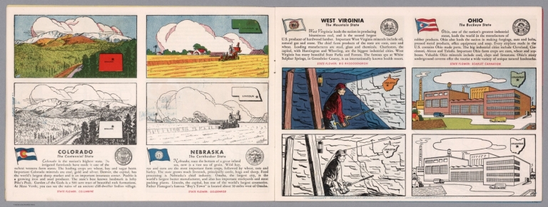


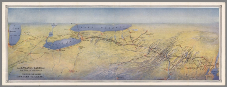


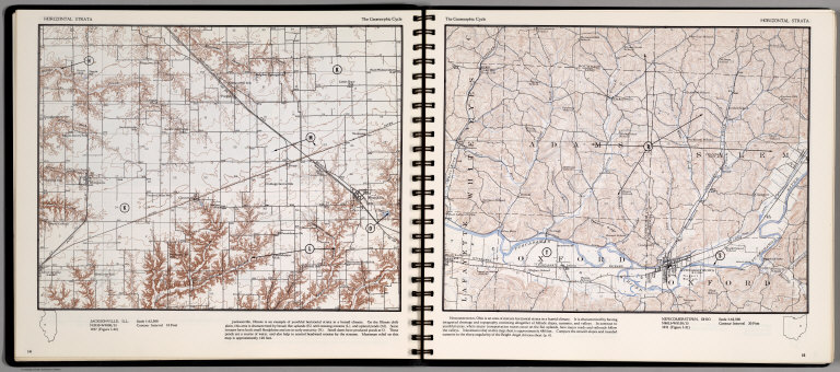


![Ohio : [South half].](https://www.davidrumsey.com/rumsey/Size2/RUMSEY~8~1/205/14372066.jpg)