|
Author
[Fletcher, Hugh., Geological Survey of Canada]
Full Title
Province of Nova Scotia (Island of Cape Breton). Geological and Natural History Survey of Canada. Alfred R.C. Selwyn, LL.D., F.R.S. &c. Director. 1884. The Burland Lith. Company Montreal. Compiled and drawn by Hugh Fletcher, from plans made by the Admiralty, the Department of Crown Lands, Nova Scotia, and the Geological Survey. To illustrate Reports by Hugh Fletcher, 1879 to 1884. Sheet no. 22.
List No
3997.024
Note
Full color. Shows geologic units, mineral deposits, mineral springs, falls, fishing stations, buildings, land holders names, schools, parish and county boundaries, notes, etc. Relief shown by spot heights. The maps index the various geological reports. Rumsey collection maps backed on linen; protected in new blue cloth folding boards with blue cloth slip case 22 x 16.5 cm., stamped with title "Cape Breton, Nova Scotia, Geological Survey of Canada, 1884" on spine in gold.
Author
[Fletcher, Hugh., Geological Survey of Canada]
Full Title
Province of Nova Scotia (Island of Cape Breton). Geological and Natural History Survey of Canada. Alfred R.C. Selwyn, LL.D., F.R.S. &c. Director. 1884. The Burland Lith. Company Montreal. Compiled and drawn by Hugh Fletcher, from plans made by the Admiralty, the Department of Crown Lands, Nova Scotia, and the Geological Survey. To illustrate Reports by Hugh Fletcher, 1879 to 1884. Sheet no. 23.
List No
3997.025
Note
Full color. Shows geologic units, mineral deposits, mineral springs, falls, fishing stations, buildings, land holders names, schools, parish and county boundaries, notes, etc. Relief shown by spot heights. The maps index the various geological reports. Rumsey collection maps backed on linen; protected in new blue cloth folding boards with blue cloth slip case 22 x 16.5 cm., stamped with title "Cape Breton, Nova Scotia, Geological Survey of Canada, 1884" on spine in gold.
Author
[Fletcher, Hugh., Geological Survey of Canada]
Full Title
Province of Nova Scotia (Island of Cape Breton). Geological and Natural History Survey of Canada. Alfred R.C. Selwyn, LL.D., F.R.S. &c. Director. 1884. The Burland Lith. Company Montreal. Compiled and drawn by Hugh Fletcher, from plans made by the Admiralty, the Department of Crown Lands, Nova Scotia, and the Geological Survey. To illustrate Reports by Hugh Fletcher, 1879 to 1884. Sheet no. 24.
List No
3997.026
Note
Full color. Shows geologic units, mineral deposits, mineral springs, falls, fishing stations, buildings, land holders names, schools, parish and county boundaries, notes, etc. Relief shown by spot heights. The maps index the various geological reports. Rumsey collection maps backed on linen; protected in new blue cloth folding boards with blue cloth slip case 22 x 16.5 cm., stamped with title "Cape Breton, Nova Scotia, Geological Survey of Canada, 1884" on spine in gold.
Author
State Farm Insurance Companies Travel Bureau
Full Title
State Farm Road map: Maritime Provinces. Copyright by Rand McNally & Company, Chicago, Ill. Lithographed in U.S.A. (on upper corners) Maritime Provinces.
List No
4246.047
Note
Color map. Shows roads, points of interest, distances, time zone boundaries, populations, etc. Main through rotes shown in red. Includes note.
Author
Schonberg & Co.
Full Title
Newfoundland, Nova Scotia, New Brunswick, Cape Breton & Prince Edward Islds. and the South Coast of Labrador.
List No
4324.007
Note
Prime meridians are Greenwich and Washington D.C. Counties differentiated by full color.
Author
Mitchell, Samuel Augustus
Full Title
Canada East. Formerly Lower Canada. Published by Thomas, Cowperthwait & Co. No. 253 Market Street. Philadelphia. Entered ... 1850 by Thomas, Cowperthwait & Co. ... Pennsylvania. (inset map) Nova Scotia, New Brunswick &c.
List No
4328.007
Note
Full color map. Shows railroads, capitals, important towns, etc. Relief shown by hachures. Prime meridian is Greenwich.
Author
[Bouchette, Joseph Jun., Bouchette, Joseph, Wyld, James, 1812-1887]
Full Title
To His most Excellent Majesty King William IVth. This Map of the Provinces of Lower & Upper Canada, Nova Scotia, New Brunswick, Newfoundland & Prince Edward Island, With A Large Section Of The United States, Compiled from the latest & most approved Astronomical observations, Authorities & recent Surveys, Is ... most humbly & gratefully dedicated by ... Joseph Bouchette Junr. Deputy Surveyor General of the Province Of Lower Canada. Engraved by J. & C. Walker, Bernard Street, Russel Square. Published ... by James Wyld ... Charing Cross, London May 2nd 1831. (inset) The British Dominions in North America. (inset) The Gulf Of St. Lawrence, shewing the Geographical position of the Principal Headlands ...
List No
4436.000
Note
First edition, to accompany the author's "British Dominions in North America." A later enlarged edition was published in New York by Sherman & Smith in 1846 (see our #5071), reprinted with additions in 1852, 1853 (no significant changes)(see NMM 479 for an atlas edition of the map, 1853). Joseph Bouchette Junior carried on his father's work and this map is a worthy successor to the elder Bouchette's 1815 map of Upper and Lower Canada. The scale is almost three times as large and the size of the map is doubled. A list of authorities is given, all Canadian, ending with "several important American Authorities" (which are unnamed). Lands belonging to the Canada Company are shown. There is a great deal of detail in the U.S. portions of the map, and attention is paid to the Maine boundary dispute with a note - but only the British claim line is shown. Outline color by state. Map has green cloth edging and is dissected into 35 sections. Folds with blue paper end sheets into a new gray cloth folding case 28x21.5 with "Upper And Lower Canada J. Bouchette, Jr. 1831" stamped in gilt on the spine.
Author
[Bradford, Thomas G., Goodrich, S.G.]
Full Title
Lower Canada And New Brunswick. (with) Nova Scotia. Engd. by G.W. Boynton. Entered ... 1838 by T.G. Bradford ... Massachusetts.
List No
4453.005
Note
In full color by area.
Author
[Meacham, J.H. & Co., Allen, C.R.]
Full Title
Dominion of Canada (Eastern Sheet).
List No
4475.009
Author
Rand McNally and Company
Full Title
Rand, McNally & Co.'s New Brunswick, Nova Scotia, and Prince Edward Island.
List No
4520.007
Note
In outline color.
Author
Mitchell, Samuel Augustus
Full Title
Canada East, formerly Lower Canada. 3. Philadelphia, Published By Charles Desilver, No. 714 Chestnut Street. Entered according to Act of Congress in the year 1856 by Charles Desilver in the Clerk's office if the District Court of the Eastern District of Pennsylvania.
List No
4557.005
Note
Tinted by county. Inset of Nova Scotia, New Brunswick &c. Meridian Greenwich. Relief shown by hachures.
Author
Cram, George Franklin
Full Title
Nova Scotia and New Brunswick. (inset) Newfoundland.
List No
4558.018
Author
Mitchell, Samuel Augustus Jr.
Full Title
County map of Nova Scotia, New Brunswick, Cape Breton Id. and Pr. Edward's Id. Entered ... 1877 by S. Augustus Mitchell, . ... Washington. (inset map): City and Harbor of Halifax.
List No
4564.009
Note
Full color map by county. Prime meridians are Greenwich and Washington.
Author
Johnson, A.J.
Full Title
Johnson's New Brunswick and Nova Scotia of the Dominion of Canada, also Newfoundland, Prince Edward and Cape Breton Is. Published by A. J. Johnson, New York. 26. 27. Entered according to the Act of Congress, in the year 1867, by A.J. Johnson in the Clerk's Office of the District Court of the United States for the Southern District of New York.
List No
4574.010
Note
Engraved color map with counties differentiated by color. Shows roads and railroads and undersea telegraph cables. Major relief shown by hachures. Alternative meridian shown is Washington (D.C.)
Author
[Bourquin, Frederick, Mitchell, Samuel Augustus, Tanner, Henry S.]
Full Title
Canada East, formerly Lower Canada. Published By S. Augustus Mitchell, N.E. corner of Market & 7th Streets, Philada. Entered according to Act of Congress in the 1846, by H.N. Burroughs, - in the Clerk's Office of the District Court of the Eastern District of Pennsylvania. 3.
List No
4578.004
Note
Lithographed. Relief shown with hachures. Shows Saint Lawrence Seaway from vicinity of Montreal downstream to 250 miles below Quebec. Includes inset of New Brunswick and Nova Scotia.
Author
Colton, G.W.
Full Title
Colton's Dominion of Canada, No. 3. The Provinces of New Brunswick & Nova Scotia and Prince Edward Island. Published by G. W & C. B. Colton & Co., No. 172 William St. New York.
List No
4587.020
Note
Prime meridians are Washington D.C. and Greenwich.
Author
Colton, G.W.
Full Title
Colton's New Brunswick, Nova Scotia, Newfoundland and Prince Edward Id. Published by G. W & C. B. Colton & Co., No. 172 William St. New York.
List No
4587.021
Note
Prime meridians are Washington D.C. and Greenwich.
Author
Arrowsmith, John
Full Title
Lower Canada, New Brunswick, Nova Scotia, Prince Edwards Id., Newfoundland, and a large portion of the United States. By J. Arrowsmith. (with) inset map of Newfoundland. (Map) 42. London, Pubd. 15 Feby. 1842, by J. Arrowsmith, 10 Soho Square.
List No
4613.042
Note
In outline color.
Author
Burr, David H., 1803-1875
Full Title
Newfoundland Nova Scotia And New Brunswick. Illman & Pilbrow Sculpt. Entered ... 1833, by Illman & Pilbrow ... New York.
List No
4628.032
Note
In full color by region.
Author
Church, A. F. (Ambrose F.)
Full Title
Church's mineral map of Nova Scotia. Shewing by symbols the outcrop of the known coal seams, gold-bearing quartz-veins and ore-beds, containing mineral of economic value and importance. Published by A.F. Church & Co., Bedford, Halifax County. [Entered ... 1889, by Ambrose F. Church, of Bedford, Nova Scotia, at the Department of Agriculture.] Canada Bank Note Co. Lim., Photo-Lith., Montreal.
List No
4637.000
Note
Shows the height of coal and gold interest in Nova Scotia. A scarce map not in any listings. Extensive notes on the minerals of Nova Scotia. The printing process is color lithography, and very well done by the Canada Bank Note Co. of Montreal. Maps has pink cloth edging, marbled end sheets, and is dissected into 24 sections. Folds into a new dark blue cloth folding case 32x26.5 with "Mineral Map Of Nova Scotia A.F. Church 1889" stamped in gold on the spine. Full color.
Author
[Blunt, Edmund M. (Edmund March), 1770-1862, Des Barres, Joseph F. W. (Joseph Frederick Wallet), 1722-1824]
Full Title
(The north eastern coast of North America from New York to Cape Canso including Sable Island by Edmund Blunt. East sheet. (with) Halifax Harbour and adjacent coast by J.F.W. Des Barres. Published & Sold by E. & G.W. Blunt, No. 154 Water Street, corner of Maiden Lane, New York. G. Ely Sct. Engd. by D.R. Harrison. Entered ... 22nd day of July 1828, by Edmund Blunt of the State of New York)
List No
4662.001
Note
Eastern sheet of 3-sheet engraved nautical chart. Contains inset. Depths shown by soundings. Light house coloring by hand in red. Guthorn notes subsequent eds. in 1844, 1847 and 1848.
Author
Blunt, Edmund M. (Edmund March), 1770-1862
Full Title
The north eastern coast of North America from New York to Cape Canso including Sable Island by Edmund Blunt. Center sheet. Published & Sold by E. & G.W. Blunt, No. 154 Water Street, corner of Maiden Lane, New York. G. Ely Sct. Engd. by D.R. Harrison. Entered ... 22nd day of July 1828, by Edmund Blunt of the State of New York.
List No
4662.002
Note
Center sheet of 3-sheet engraved nautical chart. Depths shown by soundings. Light house coloring added by hand in red. Guthorn notes subsequent eds. in 1844, 1847 and 1848.
Author
Cram, George Franklin
Full Title
New Brunswick & Nova Scotia Engraved Expressly for the Standard World Atlas.
List No
4727.061
Note
Prime meridians Washington D.C. and Greenwich. With printed color.
Author
Cram, George Franklin
Full Title
Nova Scotia (western portion). Geo. F. Cram, Engraver, Chicago, Ill.
List No
4727.062
Note
Prime meridians Washington D.C. and Greenwich. Relief shown by hachures.
Author
Cram, George Franklin
Full Title
Nova Scotia (eastern portion). Geo. F. Cram, Engraver, Chicago, Ill.
List No
4727.064
Note
Prime meridians Washington D.C. and Greenwich. Relief shown by hachures. With printed color.
Author
Cram, George Franklin
Full Title
(Composite of) Nova Scotia.
List No
4727.065
Note
Prime meridians Washington D.C. and Greenwich. Relief shown by hachures.
Author
[Jefferys, Thomas, Holland, Samuel, 1728-1801]
Full Title
A new map of Nova Scotia and Cape Britain, with the adjacent parts of New England and Canada, composed from a great number of actual surveys, and other materials regulated by many new astronomical observations of the longitude as well as latitude; with an explanation. 1755 published according to Act of Parliament by Thos. Jefferys, Geographer to His Royal Highness the Prince of Wales at the corner of St. Martins Lane, Charing Cross, London. (1760)
List No
4796.004
Note
Engraved map. Borders hand col. Relief shown pictorially. Shows Indian tribes, fishing banks, roads with distances, etc. Prime meridian: Ferro.
Author
[Gridley, Richard, Jefferys, Thomas]
Full Title
A plan of the city and fortifications of Louisburg; from a survey made by Richard Gridley, Lieut. Coll. of the Train of Artillery in 1745. ... A plan of the city and harbour of Louisburg with the French batteries that defended it and those of the English, shewing that part of Gabarus Bay in which they landed, and the ground on which they encamped during the siege in 1758. (with) A map of Gabarus Bay, adjoining Louisburg. Published by Thos. Jefferys, Geographer to the Prince of Wales at Charing Cross, Octobr. 9, 1758. Price 2s.
List No
4796.005
Note
Two engraved maps on 1 sheet, with inset. Relief shown by hachures; depths by soundings. City plan shows buildings, etc. Includes profile. "Harbour" map at (ca. 1:21,000) scale; Gabarus Bay map at (ca. 1:150,000) scale.
Author
Meyer, Joseph, 1796-1856
Full Title
Neueste Karte von Lower Canada. Unter-Canada. Nach d: besten Quellen entworfen und gezeichnet. 1844. (with) Nova Scotia, New Brunswick &c. Aus der Geographischen Graviranstalt des Bibliographischen Instituts zu Hildburghausen, Amsterdam, Paris u. Philadelphia, (1860)
List No
4807.133
Note
Engraved map. County boundaries hand col. Relief shown by hachures. Scale of inset (ca. 1:4,400,000). "Meyer's Hand-Atlas No. 51."
Author
Colton, G.W.
Full Title
Colton's New Brunswick, Nova Scotia. Prince Edward Id. & Cape Breton Id. Published by G.W. & C.B. Colton & Co., No. 172 William St. New York.
List No
4825.019
Note
Counties shown in color. Prime meridian is Washington D.C.
Author
Colton, G.W.
Full Title
Colton's New Brunswick, Nova Scotia, Newfoundland. And Prince Edward Id. Published by G.W. & C.B. Colton & Co., No. 172 William St. New York.
List No
4825.020
Note
Counties shown in color. Prime meridian is Washington D.C.
Author
Johnson, A.J.
Full Title
Johnson's New Brunswick and Nova Scotia of the Dominion of Canada, also Newfoundland, Prince Edward and Cape Breton Is. Published by Alvin J. Johnson & Co., New York. 26. 27. Entered according to the Act of Congress, in the year 1867, by A.J. Johnson in the Clerk's Office of the District Court of the United States for the Southern District of New York.
List No
4828.024
Note
Engraved color map with counties differentiated by color. Shows roads and railroads and undersea telegraph cables. Major relief shown by hachures. Alternative meridian shown is Washington (D.C.)
Author
Johnson, Alvin Jewett, 1827-1884.
Full Title
Johnson's New Brunswick and Nova Scotia of the dominion of Canada. Also Newfoundland, Prince Edward Island and Cape Breton Is. Published by Alvin Johnson & Son New York. Entered ... 1867, by A.J. Johnson ... New York. (to accompany) Johnson's New Illustrated Family Atlas Of The World ... MDCCCLXXX (1880).
List No
4830.066
Note
Engraved hand colored in outline map on 2 sheets. Shows counties differentiated by color, cities, towns, villages, roads, railroads, submarine telegraph cables, rivers and mountain ranges. Relief shown by hachures. Prime meridians are Washington and Greenwich.
Author
Greenleaf, Jeremiah
Full Title
Newfoundland Nova Scotia And New Brunswick.
List No
4850.032
Note
Full color by region.
Author
[Morse, Sidney E. (Sidney Edwards), 1794-1871, Breese, Samuel]
Full Title
Nova-Scotia, New Brunswick &c. Entered ... 1843 by Sidney E. Morse and Samuel Breese ... New York. (New York: Published by Harper & Brothers, 1845). (to accompany) Morse's Cerographic Maps. No. II.
List No
4861.018
Note
Color wax engraved map. Shows towns, road, etc. Relief shown by hachures. Prime meridian is Greenwich.
Author
[Morse, Sidney E. (Sidney Edwards), 1794-1871, Breese, Samuel]
Full Title
(Title Page/Contents to) Morse's Cerographic Maps. No.3. Plan Of Publication ... Each number will contain four coloured Maps ... If practicable, from two to three numbers will be issued every month ... The first ten numbers will form a comprehensive and elegant North American Atlas for the Library, the Counting House, and the School room ... Contents of No. III. Pennsylvania. California. Illinois. North Carolina. New-York. Harper And Brothers, 82 Cliff Street. 1845 ... Price 25 Cts.
List No
4861.021
Note
3rd. part of the nine original parts of four colored maps each, in illustrated printed wrappers, of Morse's North American Atlas. Each part is dated 1845, so we assume they were all issued in that year, one or two a month. The "Plan of Publication" on the front wrapper of each part calls for ten numbers, but only nine were issued. The wraps are decorated with a palm tree, fir tree, bear, giraffe, and four seals for each of the continents. The cheap price of the product is stressed: "Each number will contain four coloured Maps, the price of which will be twenty five cents, being about one fourth the cost of copper plate Maps of similar size." After publication of the parts, Morse also issued the complete atlas bound (see our #2301). This nine part issue is to be distinguished from the earlier three part issue of 32 uncolored maps as supplements to the New York Observer (see our #4180). This copy with the signature and ms index of Robert Rantoul of Beverly, Massachusetts, noted lawyer and reformer. Printed full color. This copy is folded into green cloth covered boards which slips into a quarter leather green cloth covered folio box titled "Morse's North American Atlas - 9 Original Parts - New York, 1845" in gold along the spine.
Author
Asher & Adams
Full Title
Asher & Adams' Maine, New Brunswick, with portions of Quebec and Nova Scotia. Entered according to Act of Congress 1874 by Asher & Adams in the Office of the Librarian of Congress at Washington.
List No
4977.010
Note
Washington Meridian. Hand tinted full color. Relief shown in hachures. Shows railroads, settlements, counties, waterways, and lakes. Inset of Westmorland. Engraved.
Author
Rand McNally and Company
Full Title
(Text Page) Dominion of Canada. Provinces and Territories, Islands, lakes, Mountains, Rivers, and Towns. Nova Scotia - Dominion and Provincial Electoral Districts, Islands, Lakes, Rivers, Towns.
List No
5028ES
Note
Geographical features keyed to map; populations of towns. Shows electric lines.
Author
Rand McNally and Company
Full Title
Commercial Atlas of America. Rand McNally Standard Map of Nova Scotia, New Brunswick, and Prince Edward Island, (The Maritime Provinces of Canada).
List No
5028.155
Note
Shows railroads and distances. Includes tables of principal cities and railroads, keyed to map.
Author
Rand McNally and Company
Full Title
(Text Page) Nova Scotia - Dominion and Provincial Electoral Districts, Islands, Lakes, Rivers, Towns. New Brunswick - Dominion and Provincial Electoral Districts, Islands, Rivers, Towns.
List No
5028ET
Note
Geographical features keyed to map; populations of towns. Shows electric lines.
Author
Rand McNally and Company
Full Title
Commercial Atlas of America. Rand McNally Black and White Mileage Map, Nova Scotia, New Brunswick, and Prince Edward Island (The Maritime Provinces of Canada).
List No
5028.156
Note
Shows railroads and distances.
Author
Bouchette, Joseph
Full Title
(Covers to) Map Of The Provinces Of Canada, New Brunswick, Nova Scotia, Newfoundland and Prince Edward Island. With A Large Section Of The United States And Exhibiting The Boundary Of The British Dominions in North America. According To The Treaties Of 1842 & 1846. Compiled from the latest and most approved Astronomical observations, Authorities and recent Surveys. By Joseph Bouchette Depy. Survr. Genl. L.C. 1846. Entered ... 1846, by Joseph Bouchette ... Canada. Entered ... 1846 by Joseph Bouchette ... New York. Engraved by Sherman & Smith New York. (with 5 inset maps).
List No
5071A
Author
Mackinlay, A. & W.
Full Title
(Covers to) Mackinlay's map of the Province of Nova Scotia, including the island of Cape Breton. Compiled from actual & recent surveys. Published By A. & W. Mackinlay, No. 135 & 137 Granville Street, Halifax, N.S. Engraved by G. Philip & Son, Liverpool. Drawn by W.A. Hendry. (1890)
List No
5076A
Note
A late edition in leather covers, 21x14, stamped in gold "Canadian Government Railways Map of Nova Scotia," and " Intercolonial Railway, Prince Edward Island Railway." The Intercolonial Railway is shown running through Orangedale in Cape Breton to Sydney and the population statistics have been updated to the 1890 census, hence the estimated dated of publication. Map dissected into 32 pieces and mounted on linen and in full, bright color.
Author
Mackinlay, A. & W.
Full Title
Mackinlay's map of the Province of Nova Scotia, including the island of Cape Breton. Compiled from actual & recent surveys. Published By A. & W. Mackinlay, No. 135 & 137 Granville Street, Halifax, N.S. Engraved by G. Philip & Son, Liverpool. Drawn by W.A. Hendry. (1890)
List No
5076.001
Note
Shows gold districts, mining areas, telegraph stations, post offices, ports of entry, forests, salt springs, etc. Relief shown by hachures. Covers also Prince Edward Island. Includes table of counties with areas and population. A late edition in leather covers, 21x14, stamped in gold "Canadian Government Railways Map of Nova Scotia," and " Intercolonial Railway, Prince Edward Island Railway." The Intercolonial Railway is shown running through Orangedale in Cape Breton to Sydney and the population statistics have been updated to the 1890 census, hence the estimated dated of publication. Map dissected into 32 pieces and mounted on linen and in full, bright color.
Author
Schonberg & Co.
Full Title
Newfoundland, Nova Scotia, New Brunswick, Cape Breton & Prince Edward Islds. and the South Coast of Labrador.
List No
5198.008
Note
Prime meridians Washington D.C. and Greenwich.
Author
Boston and Maine Railroad
Full Title
Map of the Boston & Maine Railroad and its connections, 1879.
List No
5271.001
Note
Covers New England and the Maritime Provinces with parts of New York and Quebec. Includes 5 views.
Author
Boston and Maine Railroad
Full Title
Map of the Boston and Maine Railroad and connections. Rand Avery Supply Co., Boston.
List No
5275.001
Note
Relief shown by hachures. Covers New England and the Maritime Provinces with parts of New York and Quebec. Includes timetables.
Author
Letts, Son & Co.
Full Title
Statistical & general map of Canada. No. 1. Letts's popular atlas. Letts, Son & Co. Limited, London. (1883)
List No
5371.112
Note
Colored map. Relief shown by hachures. Shows cities, railroads, lighthouses, rivers, etc. Covers Nova Scotia, Prince Edward Island and parts of New Brunswick and Quebec.
Author
Colton, G.W.
Full Title
New Brunswick, Nova Scotia, Newfoundland, and Prince Edward Id. No. 4. Published by J.H. Colton & Co., No 172 William St., New York. Entered according to the Act of Congress in the year 1855 by J.H. Colton & Co. in the Clerk's Office of the District Court of the United States for the Southern District of New York.
List No
5479.008
Note
Meridians Washington and Greenwich. Counties tinted in color.
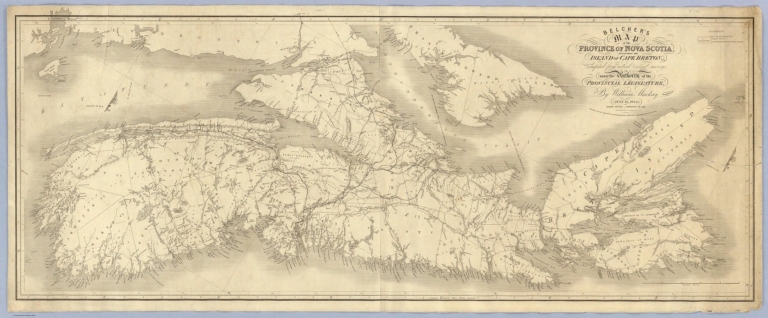
Author
Mackay, William
Full Title
Belcher's map of the Province of Nova Scotia, including the Island of Cape Breton, compiled from actual & recent surveys, & under the authority of the Provincial Legislature, by William Mackay, draughtsman. July 10, 1834. Second edition, corrected to 1855. Engraved by James Neele & Co., 3 Burleigh St., Strand. Published & sold by John Snow, 35 Patternoster Row, London; and C.H. Belcher, Halifax, Nova Scotia.
List No
5573.000
Note
Engraved map on 2 sheets; mounted together and backed in blue paper in the style of a nautical chart. Shows county and township boundaries, roads with telegraph wires, telegraph stations, lines for railways and the year when explored, sailing and mail courses, magnetic declination, etc. Oriented with north toward upper right. Relief shown by hachures. Covers a portion of Prince Edward Island.
|