|
REFINE
Browse All : Images of North America from 1804
1-12 of 12
Author
[Raif Efendi, Mahmud, Faden, William (1749-1836)]
Full Title
(North and South America)
List No
15054.065
Note
For the source map by Faden see https://www.davidrumsey.com/luna/servlet/s/5e0z2p
Author
[Mentelle, Edme, 1730-1815, Malte-Brun, Conrad, 1775-1826, Poirson, J.B.]
Full Title
XXIX. Amerique Septentroinale.
List No
12100.063
Author
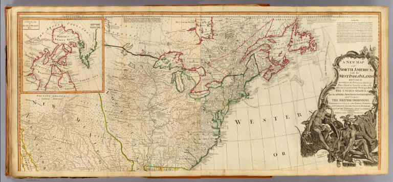
[Pownall, Thomas, Robert Laurie & James Whittle]
Full Title
A new map of North America, with the West India Islands. (North half). (with) A particular map of Baffin and Hudson's Bay. Divided according to the Preliminary Articles of Peace, signed at Versailles, 20 Jan. 1783, wherein are particularly distinguished the United States and the several provinces, governments &c. which compose the British Dominions, laid down according to the latest surveys, and corrected from the original materials of Goverr. Pownall, Membr. of Parliamt. London, Published by Laurie & Whittle, No. 53, Fleet Street, 12th May, 1794.
List No
2310.080
Note
Hand colored engraved map. Relief shown pictorially. Shows settlements, roads, Indian tribes, rivers, etc. Illustrated cartouche. Includes descriptive text. Prime meridians: Ferro and London. Printed on 2 sheets; joined.
Author
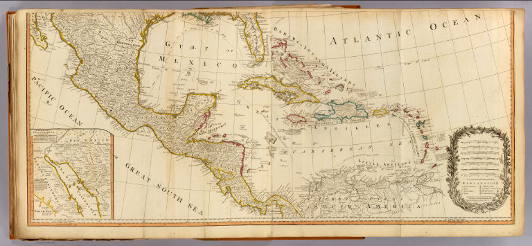
Kino, Eusebio Francisco
Full Title
(A new map of North America, with the West India Islands. South half). (with) The passage by land to California discover'd by Father Eusebius Francis Kino a Jesuit, between the years 1692 and 1701 before which and for a considerable time since California has always been described in all charts & maps as an island. (Divided according to the Preliminary Articles of Peace, signed at Versailles, 20 Jan. 1783, wherein are particularly distinguished the United States and the several provinces, governments &c. which compose the British Dominions, laid down according to the latest surveys, and corrected from the original materials of Goverr. Pownall, Membr. of Parliamt. London, Published by Laurie & Whittle, No. 53, Fleet Street, 12th May, 1794)
List No
2310.081
Note
Hand colored engraved map. Relief shown pictorially. Shows settlements, roads, Indian tribes, rivers, etc. Prime meridians: Ferro and London. Printed on 2 sheets; joined.
Author
[Kino, Eusebio Francisco, Pownall, Thomas, Robert Laurie & James Whittle]
Full Title
(Composite of) A new map of North America, with the West India Islands. (with) A particular map of Baffin and Hudson's Bay. (with) The passage by land to California discover'd by Father Eusebius Francis Kino a Jesuit, between the years 1692 and 1701 before which and for a considerable time since California has always been described in all charts & maps as an island. Divided according to the Preliminary Articles of Peace, signed at Versailles, 20 Jan. 1783, wherein are particularly distinguished the United States and the several provinces, governments &c. which compose the British Dominions, laid down according to the latest surveys, and corrected from the original materials of Goverr. Pownall, Membr. of Parliamt. London, Published by Laurie & Whittle, No. 53, Fleet Street, 12th May, 1794.
List No
2310.082
Note
Digital composite of 2 hand colored engraved maps. Relief shown pictorially. Shows settlements, roads, Indian tribes, rivers, etc. Illustrated cartouche. Includes descriptive text. Prime meridians: Ferro and London. Printed on 4 sheets; joined as 2.
Author
[Anville, Jean Baptiste Bourguignon d, 1697-1782, Robert Laurie & James Whittle]
Full Title
A new and complete map of the West Indies. Comprehending all the coasts and islands known by that name. By Monsr. Danville; with several emendations and improvements. London, Published by Laurie & Whittle, 53 Fleet Street, 12th May, 1794.
List No
2310.083
Note
Hand colored engraved map. Relief shown pictorially. Covers Mexico, Central America, the southern U.S., and northern South America. Prime meridians: Ferro and London.
Author
Patteson, Edward
Full Title
North America. E.P. delt. Neele sc., Strand. (1804)
List No
2319.013
Note
Engraved outline map to be completed by students. Faces a corresponding map with place names, etc. Relief shown by hachures.
Author
Patteson, Edward
Full Title
North America. E.P. delt. Neele sc., Strand. Published 1804, by the Revd. E. Patteson, M.A., Richmond, Surrey.
List No
2319.014
Note
Engraved map. Boundaries in outline color. Faces a corresponding outline map. Shows settlements, Indian tribes, etc. Relief shown by hachures.
Full Title
North America. Hooker sc. (Published by John Conrad & Co., Philadelphia. 1804)
List No
2436.034
Note
Engraved map, uncolored. Relief shown by hachures. Shows settlements, rivers, the larger Indian tribes, etc.
Author
Lewis, Samuel
Full Title
Louisiana. Drawn by S. Lewis. Tanner sc. (Published by John Conrad & Co., Philadelphia. 1804)
List No
2436.055
Note
Engraved map, uncolored. Relief shown by hachures. Covers the western U.S. and much of Canada and northern Mexico. Shows settlements, Indian tribes, rivers, etc. Prime meridians: Philadelphia and London.
Author
Arrowsmith, Aaron
Full Title
British possessions in America. Jones sc. From Arrowsmiths map of America. Ruld. by Hooker. (Published by John Conrad & Co., Philadelphia. 1804)
List No
2436.056
Note
Engraved map, uncolored. Relief shown by hachures. Shows settlements, Indian tribes, rivers, etc.
Author
Wilkinson, Robert
Full Title
North America, published the 12th of August 1804. By R. Wilkinson, No.58, Cornhill, London. E. Bourne Sculp.
List No
5156.000
Note
First edition. Full color. This beautiful, rare map is the first to show the entire Louisiana Territory as part of the United States, both in the delineated boundaries on the map and in the table showing the possessions of the United States: "Province, Ceded by France 30 Apr. 1803, Louisiana." The Bradley "Map of The United States..." of June 2nd, 1804, is the first map to mention the event: ôThe French call the country West of Conecuh River Louisiana & have ceded it to the United States," but the Bradley map shows only a small portion of Louisiana Territory just west of the Mississippi River. Wilkinson follows Arrowsmith's geography (from his "New Discoveries..." map of 1802) in the Rocky Mountain and the Oregon River areas, but adds new settlements and place names not on Arrowsmith's map along the northwest coast. Franklinia is shown between Tennessee and North Carolina. Wheat trashes the 1824 issue (which is unchanged from the 1804) as hopelessly out of date, but this 1804 issue was not seen by Wheat and is very accurate and forward looking for its period. The large folio General Atlas that this map appeared in is elusive: it is not listed in any references (Phillips lists only Wilkinson's smaller General Atlas issues, even though he refers to one or two issues as folio in size). Wilkinson mentions publishing it in parts, with eleven maps completed by 1808 and thirty five completed by 1823 (noted on the index pages of his quarto General and Classical Atlases of those dates). It seems to be as scarce as this North America map.
1-12 of 12
|