|
Author
[Nicholson, W. L., United States. Post Office Department]
Full Title
(Lower Part) Post route map of the Territory of Dakota with adjacent parts of Montana, Wyoming, Nebraska, Iowa and Minnesota and portions of the Dominion of Canada Designed and Constructed Under The Orders Of Postmaster General David M. Key by W.L. Nicholson Topographer of P.O. Dept. 1879.
List No
15661.002
Note
1st edition 1879, updated in ms to Jan. 1, 1880. Outline color.
Author
[Nicholson, W. L., United States. Post Office Department]
Full Title
(Upper Part) Post route map of the Territory of Dakota with adjacent parts of Montana, Wyoming, Nebraska, Iowa and Minnesota and portions of the Dominion of Canada Designed and Constructed Under The Orders Of Postmaster General David M. Key by W.L. Nicholson Topographer of P.O. Dept. 1879.
List No
15661.003
Note
1st edition 1879, updated in ms to Jan. 1, 1880. Outline color.
Author
[Nicholson, W. L., United States. Post Office Department]
Full Title
(Composite map to) (Upper and Lower Parts) Post route map of the Territory of Dakota with adjacent parts of Montana, Wyoming, Nebraska, Iowa and Minnesota and portions of the Dominion of Canada Designed and Constructed Under The Orders Of Postmaster General David M. Key by W.L. Nicholson Topographer of P.O. Dept. 1879.
List No
15661.004
Note
1st edition 1879, updated in ms to Jan. 1, 1880. Outline color.
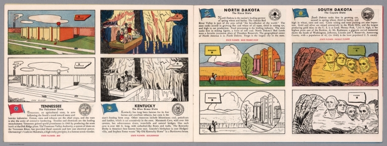
Author
[Fisher, Joseph R., Planters Peanuts (Firm)]
Full Title
Tennessee : The volunteer state -- Kentucky : The blue grass state -- North Dakota : The Sioux state -- South Dakota : The coyote state.
List No
14374.013
Note
Four views, representing Tennessee, Kentucky, North Dakota and South Dakota. Views show examples of the landscape and natural resources. Each view includes an inset map of the state, which marks the location of the capital city with a star. Accompanied by descriptive text, the state flags, seals and flowers: iris, goldenrod, wild prairie rose and pasque flower, respectively. The view of each state appears both in color (on top) and in black and white (bottom), the latter inviting coloration. Together, views are 18 x 52 cm, on two sheets 20 x 54 cm.
Author
Cram, George Franklin, 1841-1928
Full Title
Railroad and county map of Dakota & Manitoba. Geo. F. Cram, engraver and publisher, Chicago.
List No
14250.036
Note
Map of the Dakotas and Manitoba (Canada), showing railroads (both finished and unfinished), county boundaries, cities and towns, post offices and drainage. Political boundary lines in color. Includes a legend. With index numbers along the perimeter, and decorative border. Also, with hand-drawn annotations tracing routes of travel across landscapes where no official transit appears. 55 x 40 cm, on sheet 58 x 45 cm.
Author
Rand McNally & Co.
Full Title
Rand McNally & Co.'s sectional map of the Dakota and the Black Hills. Printed expressly for J. Bride & Co.'s Great American 25 Cent package, 767 and 769 Broadway, New York City. A.W. Barber, Del. Rand McNally & Co. Printers, engravers and electrotypers, 79 Madison Street, Chicago. (with 8 insets). (on verso) Rand McNally & Co.'s new railway guide map.
List No
6878.001
Note
This is one of the earliest Rand McNally maps that we have seen. The date of 1873 is determined from the only date on the map, in the inset map of Cincinnati. Uncolored sectional map with 8 insets: New mining map of Utah, St. Louis, Railroads around Baltimore and Washington, Philadelphia, New York and vicinity, Chicago, Railroad around Cincinnati, 1872-3, Denver. Showing boundaries of township, counties, states and territories, and detail diagram of township numbering system. Includes references, illustrations and advertisements. Relief shown by hachures. Prime meridian is Greenwich.
Author
Appleton, D. & Co.
Full Title
Map of South Dakota and North Dakota. Copyright 1891 by Matthews-Northrup Co. ... Buffalo, New York. (to accompany) The Library Atlas Of Modern Geography ... New York, D. Appleton And Company 1892. (on upper margin) South Dakota and North Dakota 97
List No
0026.244
Note
Color map. Shows state and county boundaries and county seat, capital, railways, roads, rivers, etc. "Size of type indicates importance of the places". Includes notes. Prime meridians are Greenwich and Washington. Relief shown by hachures.
Author
Arbuckle Bros.
Full Title
Missouri, Oregon, Iowa, North Dakota. Copyright 1889 Arbuckle Bros. N.Y.
List No
0027.003
Note
Sheet with maps of four states in full color. Oregon is noted for its salmon fisheries, and the card features a fisherman as well as canned salmon. Little is written about North Dakota, but it is noted that "the temperature varies from 20 degrees below zero to 100 degrees Fahrenheit." Each card measures 7.5 x 12.5 cm.
Author
Asher & Adams
Full Title
Asher & Adams' Dakota. Entered according to Act of Congress in the year 1874 by Asher & Adams ... at Washington. (New York, 1874)
List No
0041.034
Note
Hand col. engraved map. Shows townships, etc. Prime meridians: Greenwich and Washington.
Author
Colton, G.W.
Full Title
Minnesota. Published By J.H. Colton & Co. No. 172 William St. New York. Entered ... 1855 by J.H. Colton & Co. ... New York. No. 49.
List No
0149.054
Note
In full color. Minnesota extends from Lake Superior to the Missouri River (the middle of the present day Dakotas). Proposed route of the Pacific Railroad shown.
Author
Colton, G.W.
Full Title
Colton's Dakota and Wyoming. Published By G. W & C. B. Colton & Co. No. 172 William St. New York.
List No
0152.062
Note
Prime meridians are Washington D.C. and Greenwich.
Author
Cram, George Franklin
Full Title
Dakota.
List No
0210.047
Note
Prime meridians Greenwich and Washington.
Author
[Colton, G.W., Colton, C.B.]
Full Title
Gray's Atlas Map of Dakota. 1873. Entered ... 1873 by G.W. & C.B. Colton ....
List No
0310.070
Author
[Gray, Frank A., Gray, O.W.]
Full Title
Gray's New Map of Dakota with Part of Manitoba, Etc. by Frank A. Gray. Copyright 1883 by O.W. Gray & Son.
List No
0312.037
Author
Johnson, A.J.
Full Title
Johnson's Nebraska, Dakota, Colorado, Idaho, Kansas. By Johnson And Ward.
List No
0352.041
Note
Full color by county, with heavy outlines around the states. Idaho and Kansas printed uncolored. Interesting transitional map of the region, featuring a massive oversized Idaho. Shows rivers and springs. Relief shown by hachures. Prime meridians are Greenwich and Washington D.C.
Author
Johnson, A.J.
Full Title
Johnson's Minnesota and Dakota By Johnson and Ward.
List No
0352.042
Note
Full color, with heavy outlines around the states. Minnesota is colored by counties. Shows State capital, cities, towns, rivers, roads, railroads, canals, and route of the proposed northern Pacific Railroad. No clear administrative divisions shown for Dakota. Includes text. Relief shown by hachures. Prime meridians are Greenwich and Washington D.C.
Author
Johnson, A.J.
Full Title
Johnson's Nebraska, Dakota, Idaho, Montana and Wyoming. Entered ... 1865.
List No
0358.047
Author
Leahy, J.F.
Full Title
(Index to) Leahy's Hotel Guide and Railway Distance Maps. North Dakota.
List No
0425.092
Note
Alphabetical index list of the Hotels of the town with the number of rooms of each, their rates per day and the population of the town. Includes population of the state, and Explanation of abbreviation of the railroad of the state.
Author
Leahy, J.F.
Full Title
Leahy's Hotel Guide and Railway Distance Map of the State of North Dakota. Published by American Hotel Register Company. Leahy Build., 228-234 W. Ontario St., Chicago, Ill. Copyrighted by J.F. Leahy, Jan., 1934.
List No
0425.093
Note
Map printed without color. Includes name of the railroad entering the town, and distance between towns.
Author
Johnson, A.J.
Full Title
Johnson's Nebraska, Dakota, Idaho, and Montana Published By Johnson And Ward.
List No
0535.039
Note
Relief shown by hachures. Meridians Greenwich and Washington D.C.
Author
Mitchell, Samuel Augustus
Full Title
Minnesota, And Dacotah. 35. Entered ... 1860, by S. Augustus Mitchell, Jr. ... Pennsylvania.
List No
0565.025
Note
Minnesota in full color by county. Dacotah in full color.
Full Title
Territory of Dakota. (By S. Augustus Mitchell. 1880)
List No
0586.043
Note
Hand colored. Relief shown by hachures. Shows counties, Indian reservations, settlements, railroads, rivers, etc.
Author
Mitchell, Samuel Augustus Jr.
Full Title
County and township map of Dakota. Copyright by Wm. M. Bradley & Bro. 1884.
List No
0592.045
Note
Hand colored. Relief shown by hachures. Shows counties, Indian reservations, settlements, railroads, rivers, etc.
Full Title
County and township map of Dakota. Copyright 1887 by Wm. M. Bradley & Bro. (1890)
List No
0594.043
Note
Hand colored. Relief shown by hachures. Shows counties, Indian reservations, settlements, railroads, rivers, etc.
Author
Stevens, Isaac I.
Full Title
St. Paul to Riviere Des Lacs; from Explorations and Surveys made under the direction of the Hon. Jefferson Davis Secretary of War by Isaac I. Stevens, Governor of Washington Territory. 1853-4. Explorations and surveys for a railroad route from the Mississippi River to the Pacific Ocean. War Department. Route near the 47th and 49th parallels. Map No. 1.
List No
0693.020
Note
Uncolored map stretching from St. Paul into North Dakota.
Author
Stevens, Isaac I.
Full Title
Riviere Des Lacs to the Rocky Mountains; from Explorations and Surveys made under the direction of the Hon. Jefferson Davis Secretary of War by Isaac I. Stevens, Governor of Washington Territory 1853-4. Explorations and surveys for a railroad route from the Mississippi River to the Pacific Ocean. War Department. Route near the 47th and 49th parallels. Map No. 2. Engr. by Selmar Siebert.
List No
0693.021
Note
Uncolored map covering the area from Fort Pierre (South Dakota) on the Missouri River to the foot of the Rocky Mountains near present-day Helena, Montana.
Author
[Rand McNally and Company, Texas Company]
Full Title
Texaco road map North Dakota, South Dakota ... (inset) Yellowstone National Park. Copyright by Rand McNally & Company ... (inset) Waterton-Glacier International Peace Park, Glacier Park Section ... (1937)
List No
0806.002
Note
Relief shown by hachures and spot heights. Indexed. Includes table of gasoline taxes. In full color. Folded to 19 x 9. "S.2721."
Author
[Raynolds,W.F., Maynadier, H.E., Gillespie,G.]
Full Title
War Department Map Of The Yellowstone And Missouri Rivers And Their Tributaries explored by Capt. W.F. Raynolds Topl. Engrs. and 1st Lieut. H.E. Maynadier 10th Infy. Assistant. 1859-60. Revised and Enlarged by Major G.L. Gillespie ... 1876 ... Published by the authority of the Hon. the Secretary Of War Office of the Chief Of Engineers, U.S. Army. 1876. Engraved in the Office of the Chief of Engineers. Western Sheet Map Of Yellowstone And Missouri Rivers ... 1877.
List No
0834.000
Note
Map in 2 sheets; western sheet dated 1877. Highly detailed map, filling in much new information on the original map by Raynolds made in 1859-60 (but published in 1867). This map extends one degree further south than the original map, and for some reason the western sheet does not have the mountains drawn in although the water courses are clearly shown. Unfolded, separately issued on thin paper. Relief shown by hachures.
Author
Thayer, H. L.
Full Title
(Covers to) Thayer's Map of the Black Hills & Big Horn Country. Published By H.L Thayer Denver, Colorado. Carefully prepared from the Official Maps of the General Land Office. Explorations of Capt. Wm. Ludlow and from latest Maps of the routes of General Custer and other Officers of the Army, furnished by Capt. W.S. Stanton Chief Engr. Dept. of the Platte and from the Engineer Dept. at Washington. Entered ... 1877 by H.L. Thayer ... Washington. Edward Rollandet, Draftsman.
List No
0993.001
Note
Rare. One of the earlier Black Hills pocket maps. Wheat: "An imposing production." Border color by state. Map is folded into dark brown cloth covers 15.5x9.5 with purple label reading "Thayer's Map Of The Black Hills And Big Horn Country . One Dollar."
Author
Thayer, H. L.
Full Title
Thayer's Map of the Black Hills & Big Horn Country. Published By H.L Thayer Denver, Colorado. Carefully prepared from the Official Maps of the General Land Office. Explorations of Capt. Wm. Ludlow and from latest Maps of the routes of General Custer and other Officers of the Army, furnished by Capt. W.S. Stanton Chief Engr. Dept. of the Platte and from the Engineer Dept. at Washington. Entered ... 1877 by H.L. Thayer ... Washington. Edward Rollandet, Draftsman.
List No
0993.002
Note
Rare. One of the earlier Black Hills pocket maps. Wheat: "An imposing production." Border color by state. Map is folded into dark brown cloth covers 15.5x9.5 with purple label reading "Thayer's Map Of The Black Hills And Big Horn Country . One Dollar."
Author
[Touring club italiano, Funk & Wagnalls Company.]
Full Title
(Legend to) Stati Uniti, United States of America, Montana, North Dakota, South Dakota, Wyoming, Nebraska. Propr. Artistico-letteraria del T.C.I. Ufficio cartografico del T.C.I. (1929)
List No
1012CQ
Note
Explanation to map.
Author
[Touring club italiano, Funk & Wagnalls Company.]
Full Title
Stati Uniti, United States of America, Montana, North Dakota, South Dakota, Wyoming, Nebraska. (with Yellowstone National Park). Propr. Artistico-letteraria del T.C.I. Ufficio cartografico del T.C.I. (1929)
List No
1012.073
Note
Color map. Relief shown by hachures and spot heights. Inset map at 1:750,000 scale.
Author
U.S. General Land Office
Full Title
Dakota Territory. Department of the Interior, General Land Office, October 2nd 1866. Jo. S. Wilson, Commissioner. The Major & Knapp Eng. Mfg. & Lith. Co. 71 Broadway, N.Y.
List No
1070.008
Note
The territory is largely unsurveyed. Surveying has only been completed in a few townships right along the Missouri River. The map shows the treaty line of July 23, 1851.
Author
U.S. General Land Office
Full Title
(Map 12 - Montana, North Dakota).
List No
1071.014
Note
One of the series of adjacent sixteen maps. Mounted on linen. Relief shown in hachures.
Author
U.S. General Land Office
Full Title
Department of the Interior, General Land Office. S.S. Burdett, Commissioner.Territory of Dakota. 1876. Compiled from the official records of the General Land Office and other sources by C. Roeser, Principal Draughtsman G.L.O. Photolith. & Print by Julius Bien 16 & 18 Park Place, N.Y.
List No
11179.008
Note
Color map. Includes references. Relief shown by hachures. Prime meridian is Greenwich.
Author
Warren, Gouverneur Kemble, 1830-1882
Full Title
(Title Page to) Explorations in the Dacota Country, in the Year 1855. By Lieut. G.K. Warren, Topographical Engineer of the "Sioux Expedition." Senate. 34th Congress, 1st Session. Ex. Doc. No. 76. Washington: A.O.P. Nicholson, Senate Printer. 1856. (with map) Reconnoissances in the Dacota Country By G.K. Warren, Lieut: Topl. Engrs. U.S.A. ... P.S. Duval & Co. Lith. Philada. (profile) Profile Of Route From Fort Pierre To Fort Kearney ... 1855.
List No
1172A
Author
Warren, Gouverneur Kemble, 1830-1882
Full Title
Reconnoissances in the Dacota Country By G.K. Warren, Lieut: Topl. Engrs. U.S.A. ... P.S. Duval & Co. Lith. Philada. (profile) Profile Of Route From Fort Pierre To Fort Kearney ... 1855.
List No
1172.001
Note
The large map, 92x153, "Reconnoissances in the Dacota Country", is one of the most detailed, large scale maps of eastern Nebraska of the period. Map is without color. Bound with new cloth covered boards, "Explorations in the Dacota Country, G.K. Warren, 1856" on spine.
Author
[Warren, G.K., U. S. Army. Corps of Engineers]
Full Title
Map Of Nebraska And Dakota, And Portions Of The States And Territories Bordering Thereon, Compiled By Bv't Maj. Gen. G.K. Warren, Maj. Engineers. March, 1867 ... Engineer Dep't U.S. Army. Bv't Maj. Gen. A.A. Humphreys, Chief Of Engineers.
List No
1173.000
Note
Later version of 1858 edition. Includes routes, surveys and reconnaissances indexed by dates and name of person in charge. Not in Wheat. Unfolded separate issue. In two sheets; without color. Relief shown by hachures.
Author
Stieler, Adolf, 1775–1836
Full Title
Petermann : Vereinigte Staaten Von Nord-Amerika In 6 Blattern, Bl. 2. Bearbeitet v. H. Habenicht. Gest v. Eberhardt, Kuhn, Metzeroth & Weiler. Stieler's Hand-Atlas No. 82. Gotha: Justus Perthes. 1875.
List No
13563.105
Note
1 outline color map on 6 sheets. Sheet 2. Title from sheet 4. shows Dakota, Nebraska, Minnesota, Iowa, Wisconsin, and part of Illinois
Author
[George F. Cram Company collection 1845-1955, National Highways Association]
Full Title
North Dakota. The George F. Cram Company, Chicago. (to accompany) Auto trails and commercial survey of the United States.
List No
13688.071
Note
State of North Dakota. Showing State highway system and numbers.
Author
[George F. Cram Company collection 1845-1955, National Highways Association]
Full Title
North Dakota. The George F. Cram Company, Chicago. (to accompany) Auto trails and commercial survey of the United States.
List No
13688.072
Note
State of North Dakota. Showing administrative boundaries.
Author
Rand McNalley & Company
Full Title
Rand McNally road map : North Dakota.
List No
14003.036
Note
Road map of North Dakota, showing interstate and state highways, paved and dirt roads, as well as drainage and ports, and state and national parks. Includes compass rose, time zones, and bar scale with scale statement: One inch equals approximately 20 miles. Features legend indicating population. Copyright by Rand McNally & Company, Chicago, Ill. Lithographed in the U.S.A.
Author
[Bates, Ernest Sutherland, 1879-1939, Schiff, Herman S., Reeves, Norman, Smith, Robert E.]
Full Title
North Dakota, 1889.
List No
14244.087
Note
Pictorial map of North Dakota, showing political boundaries with bordering states. Features significant sites (Badlands), as well as natural resources and manufactured items (including alfalfa, bees, bricks and tile). Includes a compass rose and a scroll listing notable places and people - such as Pioneer Spaniards - which are pictured in vignettes below map, in order of listing. Map is 17 x 29 cm, on sheet 23 x 29 cm. Accompanied by historical text on facing page.
Author
Cram, George Franklin, 1841-1928
Full Title
North Dakota. 1899, by Geo. F. Cram.
List No
14372.127
Note
Map of North Dakota. Shows political boundaries, counties, towns, railroads, steamship lines, topography, bodies of water, drainage, coastlines and islands. Relief shown with hachures. Includes key with explanation, latitudinal and longitudinal lines, as well as a bar scale given in miles. With alphanumeric grid corresponding to "Index of North Dakota" on pages 235-236. Colored lithograph. Map is 40 x 55 cm, on double sheet 67 x 45 cm. "Index of maps" and "Index of cities" in margins, providing navigation for atlas as a whole.
Author
Mid-West Map Company
Full Title
Highway map & guide of North Dakota. Mid-West Map Company, Aurora, Mo.
List No
14430.002
Note
Pocket road map for the state of North Dakota. Shows state boundaries, cities, highways, roads, airports, parks, topography, bodies of water and drainage. Relief shown with hachures. Includes explanatory text, a legend, bar scale given in miles and compass rose with north oriented toward top of sheet. Indexed, with key on verso. Advertisements in margins. Printed in blue. Map is 40 x 53 cm, on sheet 44 x 56 cm.
Author
Colton, G.W.
Full Title
Colton's Dakota. Published By G. W & C. B. Colton & Co. No. 182 William St. New York.
List No
1550.056
Note
Prime meridians are Washington D.C. and Greenwich.
Author
[Cram, George, Wood Brothers]
Full Title
North Dakota. (to accompany) The Columbian World's Fair atlas ... Published for: Wood Brothers Cash Store ... Unadilla, New York.
List No
1773.068
Note
Outline hand color map. Shows state and county boundaries, cities and towns. Relief shown by hachures. Prime meridians are Greenwich and Washington.
Author
[Michler, Nathaniel, United States. War Department]
Full Title
Fredericksburg. Prepared by Bvt. Brig. Gen. N. Michler ... by order of ... A.A. Humphreys. 1867. (with) Map exhibiting the route of the Sioux Expedition under the command of Brig. Gen. H.H. Sibley, 1863. Compiled and projected by John H. Wagner ... (with) Map of the fight of the 14th A.C. at Buzzard Roost, Ga., February 24th, 25th and 26th, 1864 by Theo. Wiseman, A.A. ... (with) Sketch of battle of Big Mound, fought July 24th, 1863 by the expeditionary forces commanded by Brigadier General H.H. Sibley. Sketched and drawn by Joseph McCloud. (with) Sketch of the battle at Dead Buffalo Lake, July 26th, 1863, commanded by Brig. Gen. H.H. Sibley. (with) Map accompanying report of the battle of Dry Fork Creek, Mo., on the 5th of July, 1861 ... report of Capt. T.W. Sweeny ... Julius Bien & Co., Lith., N.Y. (1891-1895)
List No
1780.033
Note
Col. map with 5 ancillary maps. Relief shown by hachures.
Author
[Cram, George Franklin, Murray-Aaron, Eugene, 1852-1941.]
Full Title
North Dakota. Published by George F. Cram, Chicago, Ill. (to accompany) Cram's atlas of the world, ancient and modern : new census edition -- indexed.
List No
1910.041
Note
In full color on 2 pages. Shows administrative divisions, cities and towns, railroads, roads, rivers, etc. Prime meridian is Greenwich.
Author
Bradstreet Company
Full Title
Dakota. (to accompany) Bradstreet's Pocket Atlas Of The United States. Published Exclusively for Macullar, Parker & Company, Boston, Massachusetts ... New York: The Bradstreet Company, 1885. (on verso) Entered ... 1879, by The Bradstreet Company ... Washington.
List No
2054.054
Note
Full color map. Relief shown by hachures. Prime meridian is Washington, D.C.
Author
Rand McNally and Company
Full Title
(Text Page) Colorado. Dakota.
List No
2094CZ
Note
List of geographical features indexed to map.
Author
Rand McNally and Company
Full Title
Rand, McNally & Co.'s Dakota.
List No
2094.049
Note
Counties outlined in color. Meridians Washington and Greenwich. Railroads highlighted. Relief shown by hachures.
Author
Cram, George Franklin
Full Title
North Dakota. Geo. F. Cram, Engineer, Chicago. (1909)
List No
2134.081
Note
Map in full color. Shows counties, settlements, railroads, Public Land Survey System townships, etc.
Author
Vandermaelen, Philippe, 1795-1869
Full Title
Partie de la Nouvelle Bretagne. Amer. Sep. no. 33. (Dresse par Ph. Vandermaelen, lithographie par H. Ode. Quatrieme partie. - Amer. sept. Bruxelles. 1827)
List No
2212.238
Note
Hand col. lithographed map. Relief shown pictorially. Covers parts of Saskatchewan, Manitoba, Ontario, Montana, North Dakota and Minnesota.
Author
Vandermaelen, Philippe, 1795-1869
Full Title
Partie des Etats Unis. Amer. Sep. no. 40. Dessinee par H. Ghiesbreght. (Dresse par Ph. Vandermaelen, lithographie par H. Ode. Quatrieme partie. - Amer. sept. Bruxelles. 1827)
List No
2212.245
Note
Hand col. lithographed map. Relief shown by hachures. Shows Indians tribes with populations, route of Lewis and Clarke, etc. Covers parts of Montana, Wyoming, North and South Dakota and Nebraska.
Author
[Nicholson, W. L., United States. Post Office Department]
Full Title
(Covers to) Post route map of the Territory of Dakota with adjacent parts of Montana, Wyoming, Nebraska, Iowa and Minnesota and portions of the Dominion of Canada showing post offices with the intermediate distances and mail routes in operation on the 1st of December 1885. Published by order of Postmaster General William F. Vilas under the direction W.L. Nicholson, Topographer P.O. Dept. The first edition was issued in 1879. Note: The Service on this diagram brought up to date of Dec. 1st 1885. (seal) Post Office Department United States of America. "With celerity, certainty and security".
List No
2246A
Note
1st edition was 1879. Large scale. Outline color. Dissected into 24 sections and folded into brown cloth end sheets 25x28 with a label reading "Post Route Map Of The Territory Of Dakota." Map is protected in a new brown cloth folding case 26x29 with "Post Route Map Of Dakota 1885" stamped in gold on the spine.
Author
[Nicholson, W. L., United States. Post Office Department]
Full Title
Post route map of the Territory of Dakota with adjacent parts of Montana, Wyoming, Nebraska, Iowa and Minnesota and portions of the Dominion of Canada showing post offices with the intermediate distances and mail routes in operation on the 1st of December 1885. Published by order of Postmaster General William F. Vilas under the direction W.L. Nicholson, Topographer P.O. Dept. The first edition was issued in 1879. Note: The Service on this diagram brought up to date of Dec. 1st 1885. (seal) Post Office Department United States of America. "With celerity, certainty and security".
List No
2246.001
Note
1st edition was 1879. Large scale. Outline color. Dissected into 24 sections and folded into brown cloth end sheets 25x28 with a label reading "Post Route Map Of The Territory Of Dakota." Map is protected in a new brown cloth folding case 26x29 with "Post Route Map Of Dakota 1885" stamped in gold on the spine.
Author
U.S. General Land Office
Full Title
Department Of The Interior General Land Office N.C. McFarland, Commissioner. Territory Of Dakota. 1882. Compiled from the official Records of the General Land Office and other sources by C. Roeser, Principal Draughtsman G.L.O. Photo lith & print by Julius Bien & Co. 16 & 18 Park Place N.Y.
List No
2284.000
Note
Printed in color. Scale 18 miles to 1 inch. Shows Surveyor General's Office and Land Offices in color, towns, completed and railroads limits, Indian reservations, military reservations, outline colored county boundaries. Relief shown by hachures. Prime meridians are Greenwich and Washington, D.C.
Author
[Jones, C.H., Hamilton, T.H., Williams, J.David]
Full Title
Map of Nebraska, Dakota, Montana, and Wyoming
List No
2307.023
Note
Relief shown by hachures.
Author
Colton, G.W.
Full Title
Colton's Minnesota and Dakota.
List No
2441.108
Author
[Stieler, Adolf, Petermann, A.]
Full Title
Vereinigte Staaten Von Nord-Amerika In 6 Blattern, Bl. 2. Petermann. Bearbeitet v. H. Habenicht. Gest v. Eberhardt, Kuhn, Metzeroth & Weiler. Gotha: Justus Perthes. 1873.
List No
2449.089
Note
The United States in 6 sheets. Sheet 2 includes Dakota, Nebraska, Minnesota, Iowa, Wisconsin, and part of Illinois. In outline color.
Author
Mitchell, Samuel Augustus Jr., 1792-1868
Full Title
Minnesota and Dakota. Nebraska. (to accompany) Mitchell's New Reference Atlas for the Use of Colleges, Libraries, Families and Counting Houses. Philadelphia: Published By E.H. Butler & Co. 1865.
List No
2516.017
Note
2 Hand colored maps on 1 sheet. Relief shown by hachures. Showing administrative divisions, major cities, rivers, lakes, and mountains. Prime meridians are Greenwich and Washington.
Author
Rice, G. Jay
Full Title
(Covers to) Rice's Sectional Map Of Dakota. Published by the St. Paul Lithog. & Eng. Co. 1878. St. Paul, Minnesota. Copyright 1875 by G. Jay Rice.
List No
2579.001
Note
Early Dakota territory map. cf Karrow 11-0559; Wheat 1236 (1872 ed.). This is a later edition of a very scarce map. The first edition appears to be 1872 and is mentioned by Wheat as "perhaps the first major commercial map of that area." This edition says entered in 1875. It features very good detail on the Black Hills, railroad routes and surveys, and the ever expanding counties, towns and township and range surveys (all progressed much further than the description of the 1872 edition by Wheat). The owner of this copy, Mr. C.W. Irish (signed Flandreau, Dakota Terr, Feb 4th, 1879), has added in ms a wonderful assortment of lines indicating rainfall amounts in summer, winter, and for the year. Karrow lists editions of 1872, 1874, 1875, and 1879. He also lists an 1878 "Rice's Township Map of Dakota and the Black Hills." Map is full color by county and folded into dark brown cloth covers 14.5x9.5 stamped with "Rice's Sectional Map Of Dakota" in gold.
Author
Rice, G. Jay
Full Title
Rice's Sectional Map Of Dakota. Published by the St. Paul Lithog. & Eng. Co. 1878. St. Paul, Minnesota. Copyright 1875 by G. Jay Rice.
List No
2579.002
Note
Early Dakota territory map. cf Karrow 11-0559; Wheat 1236 (1872 ed.). This is a later edition of a very scarce map. The first edition appears to be 1872 and is mentioned by Wheat as "perhaps the first major commercial map of that area." This edition says entered in 1875. It features very good detail on the Black Hills, railroad routes and surveys, and the ever expanding counties, towns and township and range surveys (all progressed much further than the description of the 1872 edition by Wheat). The owner of this copy, Mr. C.W. Irish (signed Flandreau, Dakota Terr, Feb 4th, 1879), has added in ms a wonderful assortment of lines indicating rainfall amounts in summer, winter, and for the year. Karrow lists editions of 1872, 1874, 1875, and 1879. He also lists an 1878 "Rice's Township Map of Dakota and the Black Hills." Map is full color by county and folded into dark brown cloth covers 14.5x9.5 stamped with "Rice's Sectional Map Of Dakota" in gold.
Author
[Lloyd, H.H., Warner & Beers]
Full Title
Atlas of the United States, Map of the Territory of Dakota, and the States of Minnesota, and Nebraska. Warner & Beers, Publishers. From H.H. Lloyd & Co.'s Atlas of the United States.
List No
2585.074
Note
Relief shown in hachures.
Author
Rand McNally and Company
Full Title
North Dakota.
List No
2790.229
Author
Rand McNally and Company
Full Title
Relief Map of North Dakota.
List No
2790.231
Author
Cram, George Franklin
Full Title
North Dakota.
List No
2809.033
Note
Locations of banking towns shown by red circles. Railroads are indicated by numbers and colors and patterns, and each railroad has the same number and color and pattern in every state through which it passes. All railroads on each map are in a list keyed to the map. Border of map has a table of contents for the atlas. Relief shown by hachures. Prime meridians Washington D.C. and Greenwich.
Author
Rand McNally and Company
Full Title
(Text Page) Rand, McNally Co.'s North Dakota.
List No
2844DL
Note
Tables of railroads and geographical features keyed to map.
Author
Rand McNally and Company
Full Title
Rand, McNally & Co.'s North Dakota.
List No
2844.068
Note
Tables of railroads and chief cities keyed to map.
Author
Page, H.R. & Co.
Full Title
Page's Map of Dakota, 1886. Copyrighted 1880.
List No
2861.016
Author
Page, H.R. & Co.
Full Title
(Text) Government Lands (continued). (Index Page) Guide to Dakota.
List No
2871.024
Note
Vignette of forest and lake by E. White.
Author
Page, H.R. & Co.
Full Title
Page's Map of Dakota, 1885. Copyrighted 1880 by H.R. (Page).
List No
2871.025
Author
Johnson, A.J.
Full Title
Johnson's Minnesota And Dakota By Johnson & Browning. No. 45.
List No
2905.029
Note
In full color by county or region. Route of the proposed Pacific Railroad is shown. Note details the hunting and fighting ground for the region's Indian Nations.
Author
Warren, Gouverneur Kemble, 1830-1882
Full Title
Military Map of Nebraska and Dakota...From the Explorations made by him in 1855, 6...and in 1857...
List No
2932.000
Note
Best regional map of its area for the period; shows the Black Hills. Karrow lists three states of this map, the earliest dated 1858?, lithographed by J. Bien; the second state, same date, no Bien credit, hand colored, with "Engraving carefully revised" note; the third state, same as the second, except for an engraving credit to N. Peters, Washington, no color, and the date Karrow gives of 1859? Our copy is the third state. Karrow states that it is to accompany an unnamed Senate Ex. Document of the 35th Congress, 1st session, 1857-58. Wheat calls this map "a landmark of the period of 1859." Shows "Gold Field" in Colorado, around Auraria, which may make this one of the earliest maps to show the Colorado gold rush of 1859. The lower part of this map was reprinted in 1859 by J.H. Colton and included in his printing of Redpath's and Hinton's "Hand-Book to Kansas Territory and the Rocky Mountain's Gold Region," see our #4872. See our 1867 later edition of the same map.
Author
Colton, G.W. & C.B. & Co.
Full Title
(Covers to) Colton's Dakota. Published By G.W. And C.B. Colton & Co. No. 182 William St. New York. 1886. Copy Right 1885 By G.W. & C.B. Colton & Co. N.Y.
List No
3005.001
Note
Identical to the 1886 Colton General Atlas map, but dated 1886 on the map. Unusual burgundy cloth covers 14.5x9.5 with "Compliments Of Aug. T. Post. Banker 25 Nassau St. New York. Colton's Map Of Dakota" in gilt. These may have been special covers used by Colton for commercial customers who gave the maps to their clients. Full color by county. See also our #3426. Prime meridians are Greenwich and Washington D.C.
Author
Colton, G.W. & C.B. & Co.
Full Title
Colton's Dakota. Published By G.W. And C.B. Colton & Co. No. 182 William St. New York. 1886. Copy Right 1885 By G.W. & C.B. Colton & Co. N.Y.
List No
3005.002
Note
Identical to the 1886 Colton General Atlas map, but dated 1886 on the map. Unusual burgundy cloth covers 14.5x9.5 with "Compliments Of Aug. T. Post. Banker 25 Nassau St. New York. Colton's Map Of Dakota" in gilt. These may have been special covers used by Colton for commercial customers who gave the maps to their clients. Full color by county. See also our #3426. Prime meridians are Greenwich and Washington D.C.
Author
Page, H.R. & Co.
Full Title
(Covers to) Page's Map Of Dakota, 1881. Copyrighted 1880 by H.R. Page. A. Loehnes.
List No
3031.001
Note
1st edition, copyrighted 1880. In small print in the lower right corner is the name A. Loehnes, who we presume is the person who drew the map. A 7 page index of Dakota is included, with a catalogue of Page's maps. Many of Page's western and midwestern state maps appeared in county atlases published by Page in the mid 1880's (see our copies). Full color map by county, folded into lavender card board covers 15.5x9 with "Indexed Map Of Dakota. H.R. Page & Co., Chicago. Price 25 Cents." printed in black.
Author
Page, H.R. & Co.
Full Title
Page's Map Of Dakota, 1881. Copyrighted 1880 by H.R. Page. A. Loehnes.
List No
3031.003
Note
1st edition, copyrighted 1880. In small print in the lower right corner is the name A. Loehnes, who we presume is the person who drew the map. A 7 page index of Dakota is included, with a catalogue of Page's maps. Many of Page's western and midwestern state maps appeared in county atlases published by Page in the mid 1880's (see our copies). Full color map by county, folded into lavender card board covers 15.5x9 with "Indexed Map Of Dakota. H.R. Page & Co., Chicago. Price 25 Cents." printed in black.
Author
Bolitho, Edwin
Full Title
Dakota. (to accompany) Pocket Mining Atlas. Compiled From The Latest Official Surveys, And The Most Authentic Sources. Edwin Bolitho, Engineering and Mining Journal, New York, 1880. Price, $1.00 per copy. (on following page) Entered ... 1880 ... Washington, D.C., by Trask & Francis, Bankers ... 70 Broadway, New York ...
List No
3054.008
Note
Full color map. Prime meridian is Washington, D.C.
Author
Northern Pacific Railroad Company
Full Title
(Covers to) Map showing surveyed portion of land grant of Northern Pacific Railroad Company from Jamestown, North Dakota, to Montana boundary line ... (1895)
List No
3131A
Author
Northern Pacific Railroad Company
Full Title
(Text Page to) Map showing surveyed portion of land grant of Northern Pacific Railroad Company from Jamestown, North Dakota, to Montana boundary line ... (1895)
List No
3131B
Note
6 p. on 1 sheet. Text, tables, illus. and small map: Northern Pacific Railroad leased lines and connections.
Author
Northern Pacific Railroad Company
Full Title
Map showing surveyed portion of land grant of Northern Pacific Railroad Company from Jamestown, North Dakota, to Montana boundary line ... (1895)
List No
3131.001
Note
Shows railroads, counties, quarter sections, railroad lands sold and for sale, government lands settled and unoccupied, and those reserved for schools, Indian and military reservations, etc.
Author
Smith, J. Calvin
Full Title
(Minnesota, Wisconsin, North Dakota, South Dakota).
List No
3471.001
Note
Estimated Date. Part of a sixteen piece map combined digitally as a composite in final map of series.
Author
U.S. General Land Office
Full Title
Department Of The Interior General Land Office. William A. Richards, Commissioner. Map Of The State Of North Dakota. Compiled from the official Records of the General Land Office and other sources under the direction of Frank Bond, Chief of Drafting Division G.L.O. 1903. Compiled and Drawn by M. Hendges. Lettering by Wm. Bauman Jr. The Friedenwald Co. Photo-Lith. Balto.
List No
3534.000
Note
With printed color. Undissected and backed with linen. Folds into original black leather folder 25.5x15 with the remnants of the title stamped in gold barely readable on the spine.
Author
Rand McNally and Company
Full Title
Rand, McNally & Co.'s new business atlas map of North Dakota. Copyright, 1894, by Rand, McNally & Co. (Chicago, 1897)
List No
3565.138
Note
Col. map. Relief shown by hachures. Title in margin: Indexed atlas of the world. North Dakota.
Author
[Brown, Wm. H. & Co., Poole Brothers]
Full Title
Map of North Dakota. Great Opportunities for Men in Farming, Stock Raising, Manufacturing and all Commercial Pursuits. 100,000 Acres in the most prosperous counties of North Dakota are offered by us on terms so easy ... Wm. H. Brown & Co.'s Lands Shown In Red. Copyrighted, 1901, by Poole Bros., Chicago.
List No
3667.000
Note
A land promotion map, with great come-ons: "Just the place for a Hustling Wide-Awake." Printed in full color by county. Includes "Explanation" of symbols displayed on the map. Relief shown by hachures. Prime meridian is Washington, D.C.
Author
[Warner, Higgins & Beers, Lloyd, H.H.]
Full Title
Atlas of the United States. Map of the territory of Dakota and the states of Minnesota and Nebraska. Warner, Higgins & Beers Publishers. From H. H. Lloyd & Co.,s. Atlas of the United States. (to accompany) Atlas of the State of Illinois To Which Is Added An Atlas Of The United States Maps of The Hemispheres &c. &c. &c. Warner, Higgins & Beers Publishers. 143 Clark St. Chicago. 1871.
List No
3749.040
Note
Outline hand colored lithographed map. Showing state and county boundaries, cities, towns, rivers, roads and railroads. Relief shown by hachures. Prime meridians are Washington, D.C. and Greenwich.
Author
Colton, G.W.
Full Title
Colton's Dakota.
List No
3800.109
Author
Mitchell, Samuel Augustus Jr.
Full Title
County map of Colorado, Wyoming, Dakota, Montana. Entered ... 1874, by S. Augustus Mitchell ... Washington.
List No
3804.043
Note
Hand colored map by county and town. Shows settlements, roads, railroads, rivers,etc. Relief shown by hachures. Prime meridians are Greenwich and Washington.
Author
[Gray, Ormando Willis, Colton, G. Woolworth]
Full Title
Dakota.
List No
3888.043
Note
Prime meridians Washington D.C. and Greenwich. Relief shown by hachures.
Author
Rand McNally and Company
Full Title
Map of Dakota. Drawn From Official Plats Of Public Surveys, And Published In The Interest Of Immigration By The Chicago, Milwaukee & St. Paul Railway Co. Copyright, 1882, by Rand, McNally & Co., Map Publishers, Chicago, Ill. Rand, McNally & Co., Engr's Chicago ...
List No
3966.000
Note
Separately published map of the Territory that did not appear in any Rand McNally atlases of the period. A note at the bottom says "All information relating to Dakota method of obtaining Farms under the Homestead, Pre-emption or Tree Claim Laws, and full particulars touching Public or Government Lands lying adjacent to the Company's Line, etc., together with a copy of the Map, will be promptly furnished by addressing W. E. Powell, General Immigrant Agent, C., M. & St. P. R'y, Milwaukee, Wis." See the Rand McNally Indexed County and Township Map of Dakota of 1882 for a slightly different version of this map. Printed in full color by county.
Author
National Map Company
Full Title
North Dakota. (Copyrighted by) National Map Company, Indianapolis. (to accompany) Official Paved Road and Commercial Survey of the United States.
List No
4048.046
Note
Outline color map. Shows administrative divisions, roads, rivers, etc. Relief shown by hachures. Prime meridian is Greenwich.
Author
State Farm Insurance Companies Travel Bureau
Full Title
State Farm Road map: North Dakota. Copyright by Rand McNally & Company, Chicago, Ill. Lithographed in U.S.A. Z.3607. (on upper corners) North Dakota.
List No
4246.037
Note
Color map. Shows roads, points of interest, distances, time zone boundaries, populations, etc. U.S. interstate and principal state highways shown in red. Relief shown by hachures.
Author
Clason Map Company
Full Title
Clason's Road Map of North Dakota. Showing paved roads, All weather roads and other throughfares. (U.S. Highways shown in red.) Published by the Clason Map Co., Denver. Copyrighted Clason Map. All rights reserved. Map No. R-283A.
List No
4423.034
Note
Color map. Includes road legend, and Index of cities and towns giving 1930 Census populations and Key to map.
Author
Rand McNally and Company
Full Title
(Covers to) Rand McNally & Co.'s Dakota. Copyright, 1882, by Rand, McNally & Co., Map Publishers, Chicago, Ill. Rand, McNally & Co., Engr's. Chicago. (with 15 page index) Rand McNally & Co.'s Indexed County And Township Map Of Dakota... Chicago, U.S.A.: Rand, McNally & Co. ... (on verso) Entered ... 1882, by Rand, McNally & Co. ... Washington.
List No
4502.001
Note
A large and very early Rand McNally map of Dakota that does not appear in the Indexed Atlas of 1881 or 1882. Another version was published for the Chicago, Milwaukee & St. Paul Railway Co. in 1882 (see our copy). Folded into tan card board covers 17x11 printed with same title as index. Prime meridians are Greenwich and Washington D.C. Relief shown by hachures.
Author
Rand McNally and Company
Full Title
(Title page to) Rand McNally & Co.'s Dakota. Copyright, 1882, by Rand, McNally & Co., Map Publishers, Chicago, Ill. Rand, McNally & Co., Engr's. Chicago. (with 15 page index) Rand McNally & Co.'s Indexed County And Township Map Of Dakota... Chicago, U.S.A.: Rand, McNally & Co. ... (on verso) Entered ... 1882, by Rand, McNally & Co. ... Washington.
List No
4502.002
Note
A large and very early Rand McNally map of Dakota that does not appear in the Indexed Atlas of 1881 or 1882. Another version was published for the Chicago, Milwaukee & St. Paul Railway Co. in 1882 (see our copy). Folded into tan card board covers 17x11 printed with same title as index. Prime meridians are Greenwich and Washington D.C. Relief shown by hachures.
Author
Rand McNally and Company
Full Title
Rand McNally & Co.'s Dakota. Copyright, 1882, by Rand, McNally & Co., Map Publishers, Chicago, Ill. Rand, McNally & Co., Engr's. Chicago. (with 15 page index) Rand McNally & Co.'s Indexed County And Township Map Of Dakota... Chicago, U.S.A.: Rand, McNally & Co. ... (on verso) Entered ... 1882, by Rand, McNally & Co. ... Washington.
List No
4502.003
Note
A large and very early Rand McNally map of Dakota that does not appear in the Indexed Atlas of 1881 or 1882. Another version was published for the Chicago, Milwaukee & St. Paul Railway Co. in 1882 (see our copy). Folded into tan card board covers 17x11 printed with same title as index. Prime meridians are Greenwich and Washington D.C. Relief shown by hachures.
Author
Rand McNally and Company
Full Title
Rand, McNally & Co.'s Dakota.
List No
4520.043
Note
States in outline color by county. Relief shown by hachures. Shows named railroads. Prime meridians: Greenwich and Washington.
Author
Cram, George Franklin
Full Title
Cram's Rail Road & Township Map of Dakota.
List No
4533.027
|