|
REFINE
Browse All : Images of North America from 1825
1-22 of 22
Author
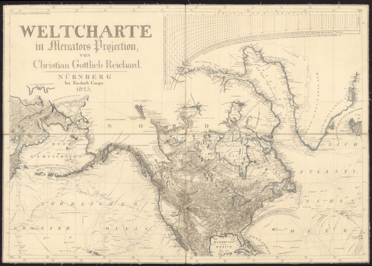
Reichard, C. G.
Full Title
(Sheet 1) Weltcharte in Mercators Projection; von Christian Gottlieb Reichard.
List No
15866.001
Note
Scale is at the Equator.
Author
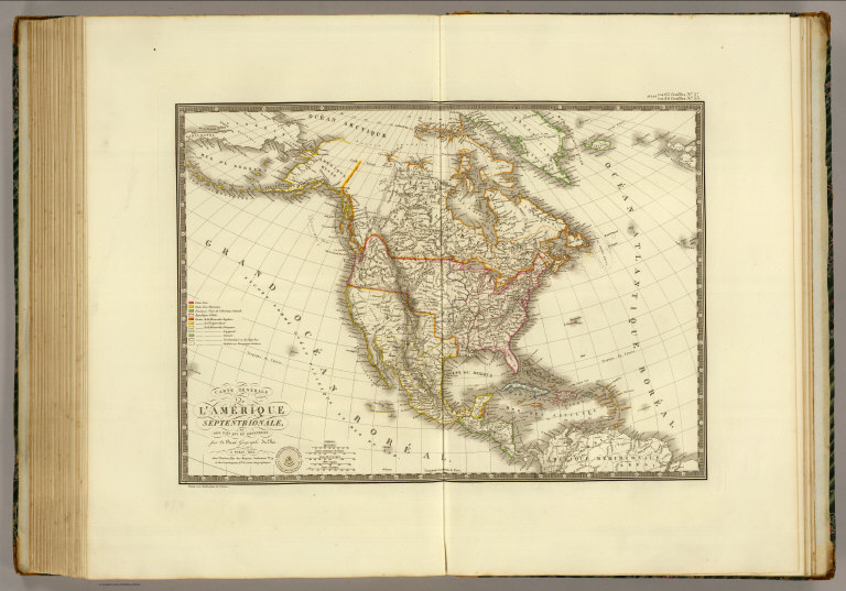
Brue, Adrien Hubert, 1786-1832
Full Title
Carte generale de l'Amerique Septentrionale, et des iles qui en dependent. Par A. Brue, Geographe du Roi. Paris, 1825. Chez l'Auteur, rue des Macons Sorbonne, no. 9, et chez les principaux m(archan)ds de cartes geographiques.
List No
0096.058
Note
Hand colored engraved map. Relief shown by hachures. Prime meridian: Paris.
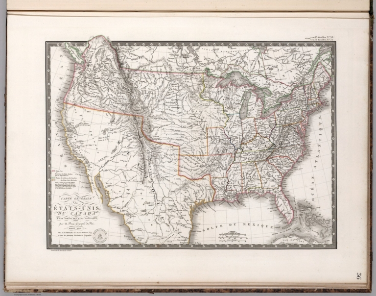
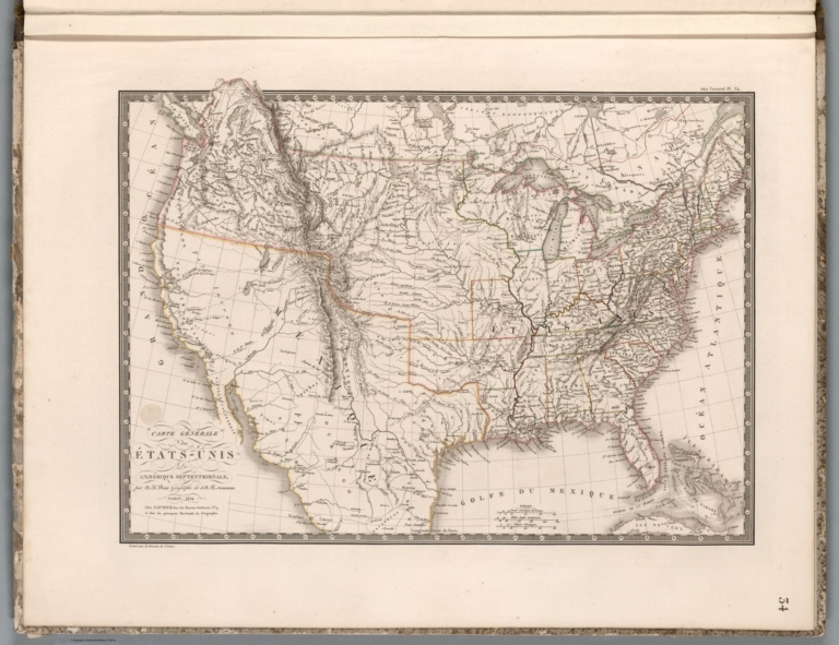
Author
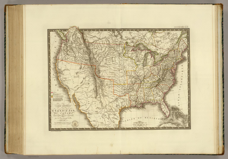
Brue, Adrien Hubert, 1786-1832
Full Title
Carte generale des Etats-Unis, du Canada et d'une partie des pays adjacents; par A. Brue, Geographe du Roi. Paris, 1825. Chez l'Auteur, rue des Macons-Sorbonne, no. 9, et chez les principaux marchands de geographie.
List No
0096.059
Note
Hand colored engraved map. Relief shown by hachures. Covers also Northern Mexico. Shows states, Indian tribes, etc. Prime meridian: Paris.
Author
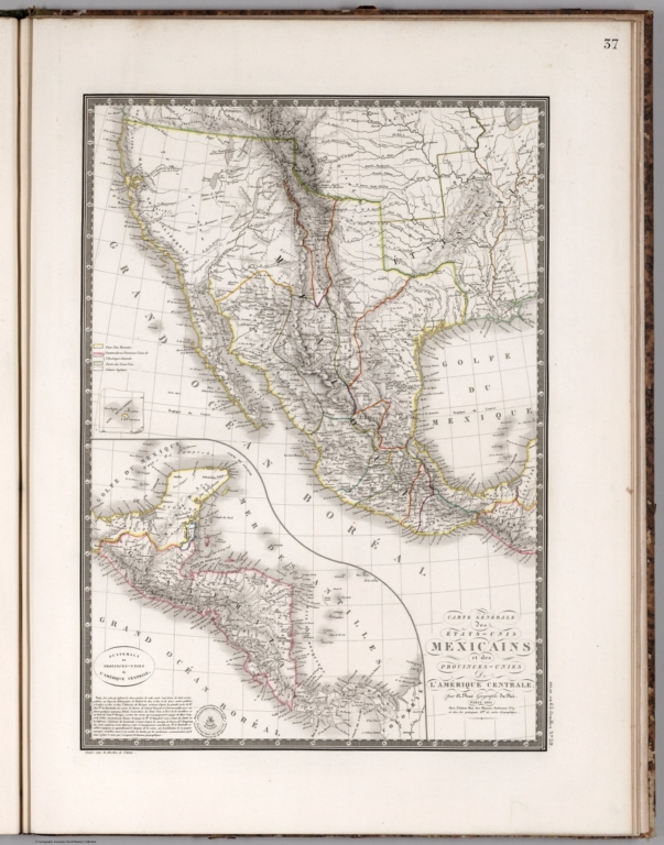
Brue, Adrien Hubert, 1786-1832
Full Title
Carte generale des Etats-Unis Mexicains et des Provinces-Unies de l'Amerique Centrale. (with) Guatemala ou Provinces-Unies de l'Amerique Centrale. Redigee par Brue, Geographe. Paris, 1825. Chez l'Auteur, rue des Macons-Sorbonne, no. 9, et chez les principaux m(archan)ds de cartes geographiques.
List No
0096.060
Note
Hand colored engraved map. Relief shown by hachures. Prime meridian: Paris. Central America shown in inset.
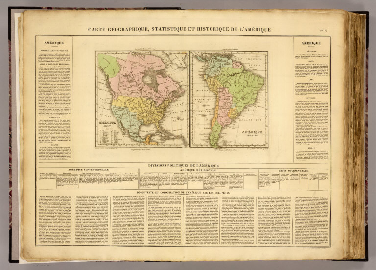
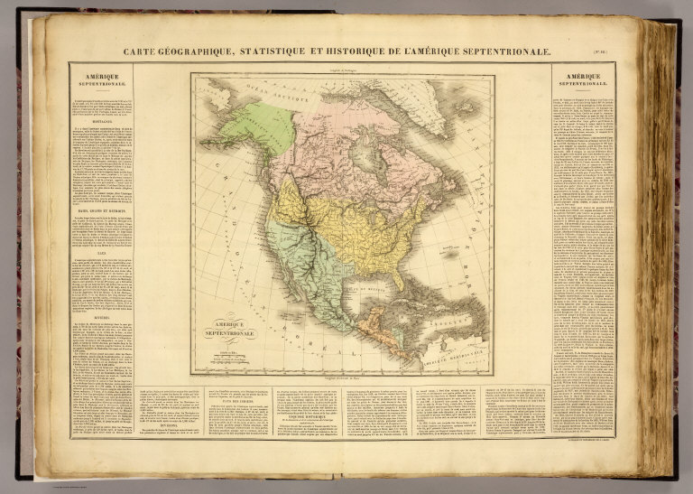
Full Title
Carte geographique, statistique et historique de l'Amerique. Amerique Sept. Grave par B. Beaupre, Rue de Vanguard No. 81. Amerique Merid. ... Fonderie et Imprimerie de J. Carez. (1825)
List No
0102.001
Note
Two hand colored engraved maps. Relief shown by hachures. Text and tables at sides and bottom. Prime meridians: Washington and Paris.
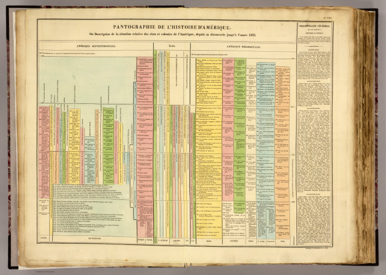
Buchon, J. A. C.; Carey, H. C.; Lea, I. Pantographie de l'histoire d'Amerique. 1825 0102.002 Related Full Title
Pantographie de l'histoire d'Amerique, ou description de la situation relative des etats et colonies de l'Amerique, depuis sa decouverte jusqu'a l'annee 1825. Fonderie et Imprimerie de J. Carez.
List No
0102.002
Note
Hand colored engraved table. Includes column of text at right.
Full Title
Carte geographique, statistique et historique de l'Amerique Septentrionale. Amerique Septentrionale. Grave par B. de Beaupre, Rue de Vaugirard No. 81, a Paris. Fonderie et Imprimerie de J. Carez. (1825)
List No
0102.003
Note
Hand colored engraved map. Relief shown by hachures. Text at sides and bottom. Prime meridians: Washington and Paris.
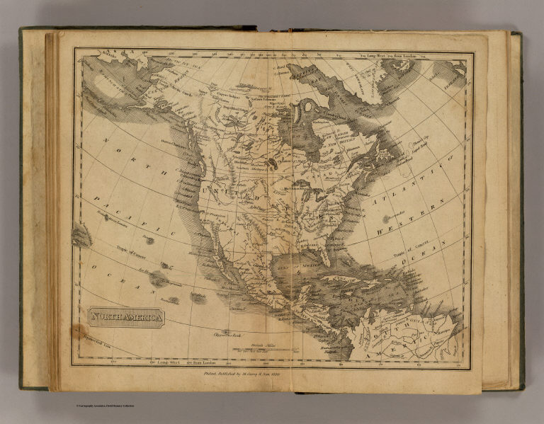
Full Title
North America. Philad., Published by M. Carey & Son, 1820. (1825)
List No
0124.012
Note
Engraved map. Relief shown pictorially.
Andriveau-Goujon, J.; Brue, Adrien Huber... Carte general des Etats-Unis, du Canada ... 1825 11124.039 Related Author
[Andriveau-Goujon, J., Brue, Adrien Hubert, 1786-1832]
Full Title
Carte general des Etats-Unis, du Canada et d'Une partie des pays adjacents. par A.H. Brue, Geographe du Rio. Paris 1825. Chez l'Auteur, rue des Macons Sorbonne, no. 9, et chez les principaux marchands de geographie. (to accompany) Atlas de choix ou Recueil de cartes de geographie ancienne et moderne.
List No
11124.039
Note
Outline hand color engraved map. Shows political boundaries, towns, villages, roads, etc. Relief shown by hachures. Prime meridian is Paris. Includes color coded reference.
Andriveau-Goujon, J.; Brue, Adrien Huber... Carte general des Etats-Unis Mexicains e... 1825 11124.040 Related Author
[Andriveau-Goujon, J., Brue, Adrien Hubert, 1786-1832]
Full Title
Carte generale des Etats-Unis Mexicains et des Provinces-Unies de l'Amerique Centrale, par A.H. Brue, Geographe du Rio. Paris 1825. Chez l'Auteur, rue des Macons Sorbonne, no. 9, et chez les principaux marchands de geographie. (insets) Guatemala ou Provinces-Unies de l'Amerique Centrale. (with) Iles Revillagigedo. (to accompany) Atlas de choix ou Recueil de cartes de geographie ancienne et moderne.
List No
11124.040
Note
Outline hand color engraved map. Shows political boundaries, towns, villages, roads, etc. Relief shown by hachures. Prime meridian is Paris. Includes text and color coded refernce.
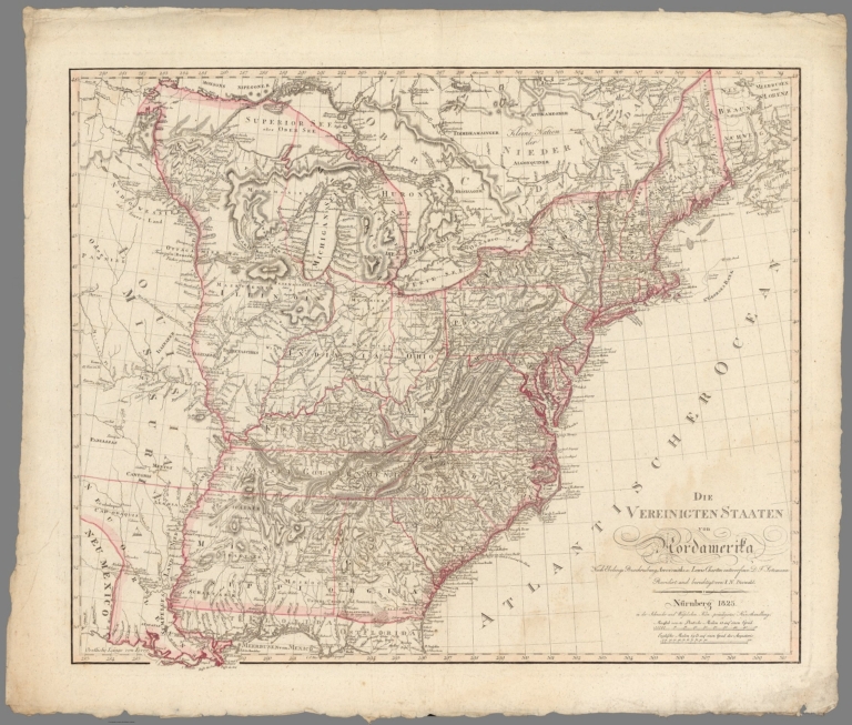
Sotzmann, Daniel Friedrich; Diewald, Joh... Die Vereinigten Staaten von Nordamerika 1825 11307.000 Related Author
[Sotzmann, Daniel Friedrich, Diewald, Johann Nepomuk]
Full Title
Die Vereinigten Staaten von Nordamerika nach Ebelings Beschreibung, Arrowsmith's u. Lewis Charten entworfen v. D.F. Sotzmann Revidirt und Berichtigtn von I.N. Diewald. Nurnberg 1825.
List No
11307.000
Note
Copper plate outline color map of the United States, published in Nuremberg 1825. Includes annotations throughout, place names, rivers and lakes. Relief shown by hachures. Prime meridian is Ferro. One of the most noteworthy features is the massive depiction of Illinois Territory, shows Illinois extending to Lake Superior and the Lake of the Woods, the largest depiction we have ever seen, extending far into modern day Canada. Many Indian Tribes are noted. In the northeast of Illinois, the boundary is shown following the Wabash River a bit too far northeast, resulting in a large encroachment into Indiana. The boundaries reflect one of the few extent map of the whole of Illinois Territory, which existed as a territory from 1809 to 1818. The Illinois Territory originally included lands that became the states of Illinois, Wisconsin, the eastern portion of Minnesota, and the western portion of the upper peninsula of Michigan. As Illinois was preparing to become a state, the remaining area of the territory was attached to the Michigan Territory. To the South, the map shows a massive Mississippi Territory.
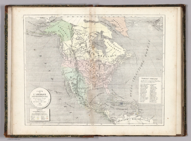
Selves, Henry Antoine Auguste; France. C... Carte de l'Amerique Septentrionale 1825 13006.009 Related Author
[Selves, Henry Antoine Auguste, France. Conseil Royal de l'instruction publique]
Full Title
Carte de l'Amerique Septentrionale : dressee pour l'usage des Colleges. Edi.on Revue Avec Soin 1825 A Paris. Impr.ie de H. Selves, lithographe de l'Universite. (to accompany) Atlas geographique ... 3eme partie, Geographie moderne actuelle ... 1823.
List No
13006.009
Note
Revised edition, hand colored double page map of North America and part of Central America. Shows the United States after the Louisiana Purchase and an extended Mexico going far north to Oregon, and modern-day Texas shown mostly as part of Mexico with some of the northern portion belonging to the U. S. Also showing capitals, major cities, rivers and mountains. Relief shown by hachures. Includes a table of the provinces of the United States and color coded table of the United States and European possessions.
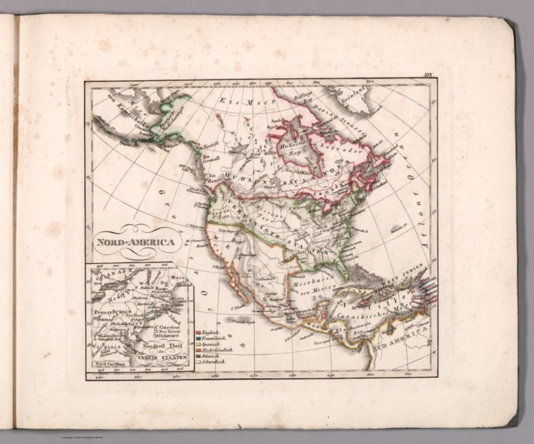
Author
Stieler, Adolf
Full Title
Nord - America. (to accompany) Atlas ofver alla verldens delar. Upsala, Palmblad & Co. 1825.
List No
13428.028
Note
Engraved hand colored in outline map, including Canada, the United States and Central America. Inset: Nordostl. theil der verein staaten. Shows political boundaries. and northeastern states.
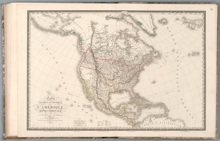
Author
Brue, Adrien Hubert, 1786-1832
Full Title
Carte physique et politique de l'Amerique septentrionale, par A.H. Brue ... Paris, Chez J. Goujon Editeur - Proprietaire ... 1821. (to accompany) Atlas physique et politique des cinq parties du monde, par H. Brue.
List No
13565.039
Note
Outline hand color engraved map of North America. Includes color coded reference to European possessions in North America.
Author
Brue, Adrien Hubert, 1786-1832
Full Title
Carte generale des Etats Unis de l'Amérique Septentrionale, par A.H. Brue ... A Paris 1824, Chez l'Auteur, 1824. (to accompany) Atlas physique et politique des cinq parties du monde, par H. Brue.
List No
13565.042
Note
Outline hand color engraved map. In upper right margin: "Atlas Universel Pl. 54."
Author
Arrowsmith, Aaron Jr.
Full Title
North America. London, Published Jany. 4.1825 by A. & S. Arrowsmith, No.10 Soho Square.
List No
2550.042
Note
Hand color map, with colored boundaries. Showing regions, place names, rivers, canals, etc. Relief shown by hachures. Prime meridian is Greenwich.
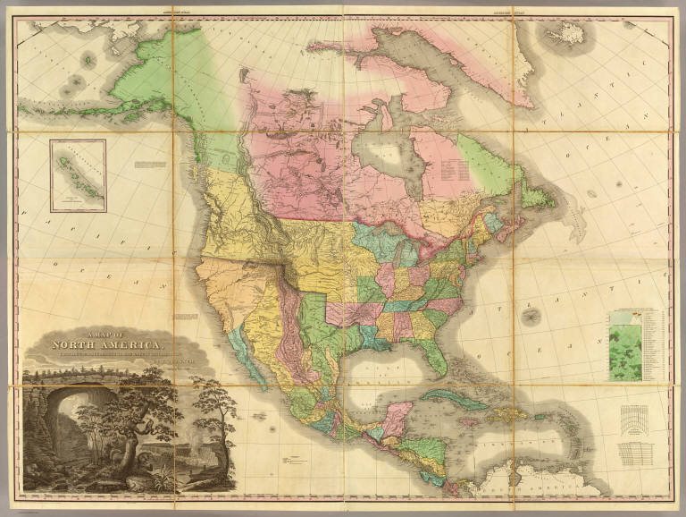
Author
Tanner, Henry S.
Full Title
A Map Of North America, Constructed According To The Latest Information: By H.S. Tanner. Improved to 1825. (with) Western Part of the Alleutian Islands. (with) Comparative Altitudes Of The Mountains, Towns &c. Of North America. American Atlas. Entered ... 27th day of May 1822, by H.S. Tanner ... Pennsylvania. Printed by Wm. Duffee. Engraved & Published by H.S. Tanner, Philadelphia, 1822.
List No
2755.007
Note
Full color map in 16 sections mounted with linen. Large line drawing of Niagara Falls and the Natural Bridge in Virginia in lower left corner. Altitudes of mountain and towns noted in chart accompanying diagram.
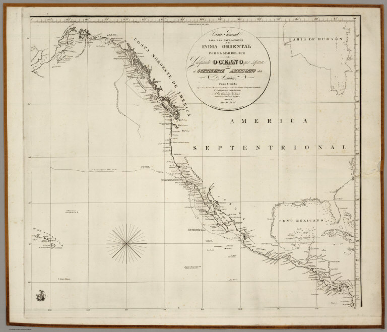
(Espinosa y Tello, J.); Mexico Republica Carta General Para Las Navegaciones a la... 1825 3775.001 Related Author
[Mexico Republica, (Espinosa y Tello, J.)]
Full Title
Carta General Para Las Navegaciones a la India Oriental Por El Mar Del Sur Y el grande Oceano que Separa el Continente Americano del Asiatico, Construida Segun las derrotas, Observaciones y trabajos de los mas Celebres Naveganles Espanoles Y Publicada por Orden del Exmo Sr. D. Guadalupe Victoria Primer Presidente de la Republica Mexico Ano de 1825. Los numberos de la Sonda son braxas de 6 pics de Burgos. (inset map on sheet 2) Plano Geometrico del Embocadero De S. Bernadino ano 1792. (inset map) Parte De La Isla De Samar.
List No
3775.001
Note
One map on 2 sheets. West sheet. First Mexican edition of Espinosa y Tello's chart of 1814, London. In two sheets, one covering the western coast of America, the other the eastern coast of Asia. The original London edition was in six sheets, and the two sheets of the Mexican edition have borders that suggest another four sheets, although it is not known if they were printed. Map is without color. "Longitude oeste de Cadiz". Emblem with eagle perched on boat surrounded by 2 sails and 2 anchors in lower left corner of the east sheet. Relief shown by hachures. Depth by soundings. Shows routes of Spanish voyages and date of exploration in the Pacific, including the Northwest Coast of North America. Covers northwest coast of America, Kamchatka, Japan, the Philippines, Hawaii & most of Micronesia.
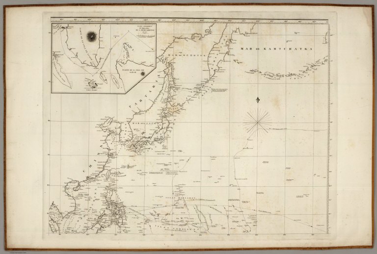
(Espinosa y Tello, J.); Mexico Republica Carta General Para Las Navegaciones a la... 1825 3775.002 Related Author
[Mexico Republica, (Espinosa y Tello, J.)]
Full Title
Carta General Para Las Navegaciones a la India Oriental Por El Mar Del Sur Y el grande Oceano que Separa el Continente Americano del Asiatico, Construida Segun las derrotas, Observaciones y trabajos de los mas Celebres Naveganles Espanoles Y Publicada por Orden del Exmo Sr. D. Guadalupe Victoria Primer Presidente de la Republica Mexico Ano de 1825. Los numberos de la Sonda son braxas de 6 pics de Burgos. (inset map on sheet 2) Plano Geometrico del Embocadero De S. Bernadino ano 1792. (inset map) Parte De La Isla De Samar.
List No
3775.002
Note
One map on 2 sheets. East sheet. First Mexican edition of Espinosa y Tello's chart of 1814, London. In two sheets, one covering the western coast of America, the other the eastern coast of Asia. The original London edition was in six sheets, and the two sheets of the Mexican edition have borders that suggest another four sheets, although it is not known if they were printed. Map is without color. "Longitude oeste de Cadiz". Emblem with eagle perched on boat surrounded by 2 sails and 2 anchors in lower left corner of the east sheet. Relief shown by hachures. Depth by soundings. Shows routes of Spanish voyages and date of exploration in the Pacific, including the Northwest Coast of North America. Covers northwest coast of America, Kamchatka, Japan, the Philippines, Hawaii & most of Micronesia.
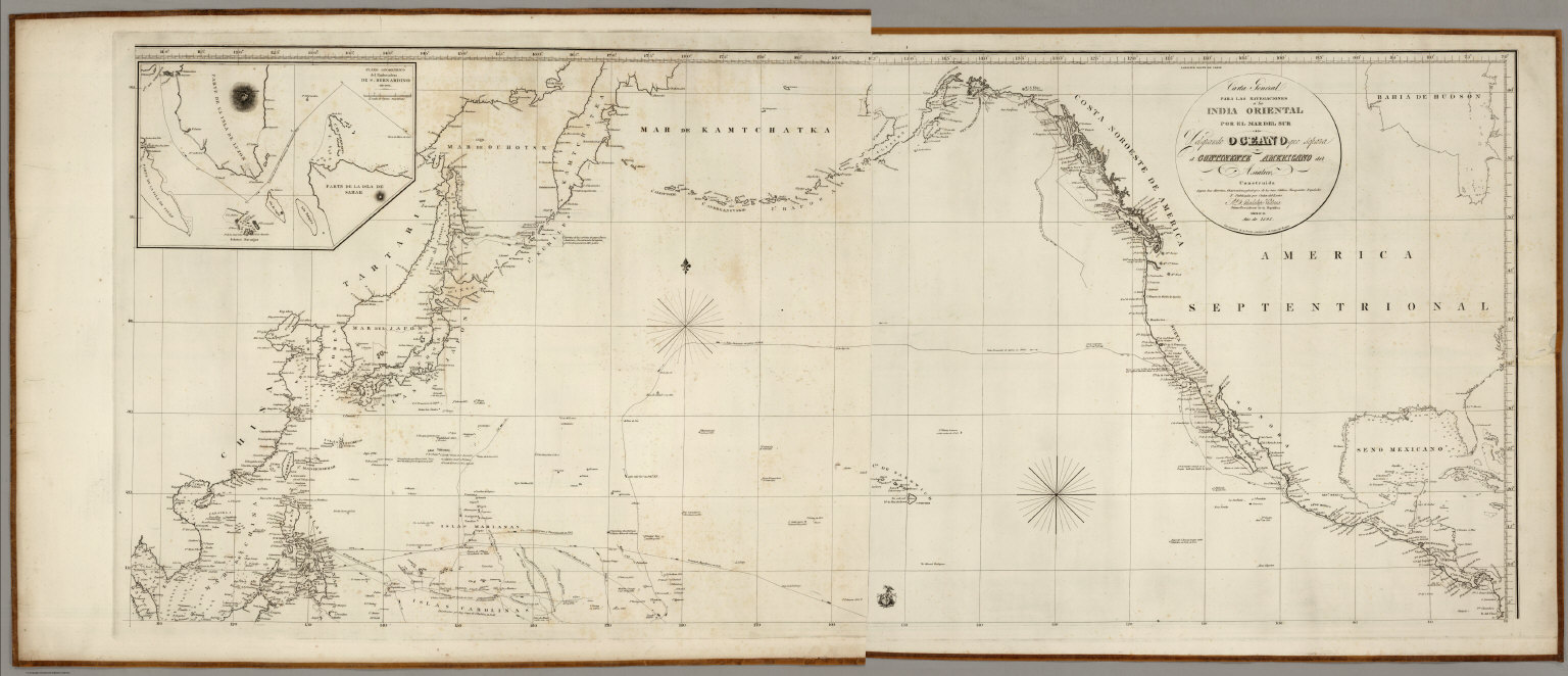
(Espinosa y Tello, J.); Mexico Republica Composite: Carta General Para Las Navega... 1825 3775.003 Related Author
[Mexico Republica, (Espinosa y Tello, J.)]
Full Title
(Composite of) Carta General Para Las Navegaciones a la India Oriental Por El Mar Del Sur Y el grande Oceano que Separa el Continente Americano del Asiatico, Construida Segun las derrotas, Observaciones y trabajos de los mas Celebres Naveganles Espanoles Y Publicada por Orden del Exmo Sr. D. Guadalupe Victoria Primer Presidente de la Republica Mexico Ano de 1825. Los numberos de la Sonda son braxas de 6 pics de Burgos. (inset map on sheet 2) Plano Geometrico del Embocadero De S. Bernadino ano 1792. (inset map) Parte De La Isla De Samar.
List No
3775.003
Note
One map on 2 sheets, here with the two sheets joined digitally.
Author
Vivien de St Martin, L.
Full Title
Carte de l'Amerique Septentrionale avec les Regions Polaires. Par L. Vivien, Geographe. Grave par Giraldon Bovinet. 1825. Paris. Chez Menard et Desenne, Rue Git le Coeur, No. 8.
List No
5017.055
Note
Engraved. Countries outlined in color. In French. Relief shown by hachures.
Author
Ruhle von Lilienstern, August
Full Title
Nordliches America. Berlin 1824 von R.v.L.
List No
5759.026
Note
Shows relief in hachures, hydrography, settlements, and countries outlined in color.
1-22 of 22
|