|
Author
Lewis, Samuel
Full Title
Louisiana. Drawn by S. Lewis. Tanner sc. (Boston: Published by Thomas & Andrews. 1812)
List No
0028.050
Note
Engraved map, uncolored. Relief shown by hachures. Covers the western U.S. and much of Canada and northern Mexico. Shows settlements, Indian tribes, rivers, etc. Prime meridians: Philadelphia and London.
Author
Arrowsmith, Aaron
Full Title
British Possessions in America. Jones sc. From Arrowsmiths map of America. Ruld. by Hooker. (Boston: Published by Thomas & Andrews. 1812)
List No
0028.051
Note
Engraved map, uncolored. Relief shown by hachures. Shows settlements, Indian tribes, rivers, etc.
Author
[Bartholomew, John, Black, Adam & Charles]
Full Title
(Covers to) Black's Atlas Of North America. A Series Of Twenty Maps Constructed And Engraved By John Bartholomew. With Introductory Letter-Press And A Complete Index. Edinburgh: Adam And Charles Black. MDCCCLVI.
List No
0073A
Note
Bound in dark green cloth covered boards with "Black's Atlas Of North Ame(rica)" on the spine in gilt (the "rica" in parentheses is missing from the original spine).
Author
[Bartholomew, John, Black, Adam & Charles]
Full Title
(Title Page to) Black's Atlas Of North America. A Series Of Twenty Maps Constructed And Engraved By John Bartholomew. With Introductory Letter-Press And A Complete Index. Edinburgh: Adam And Charles Black. MDCCCLVI.
List No
0073B
Author
[Bartholomew, John, Black, Adam & Charles]
Full Title
(Table of Contents to) Black's Atlas Of North America. A Series Of Twenty Maps Constructed And Engraved By John Bartholomew. With Introductory Letter-Press And A Complete Index. Edinburgh: Adam And Charles Black. MDCCCLVI.
List No
0073C
Author
[Bartholomew, John, Black, Adam & Charles]
Full Title
(Text Page in) Black's Atlas Of North America. A Series Of Twenty Maps Constructed And Engraved By John Bartholomew. With Introductory Letter-Press And A Complete Index. Edinburgh: Adam And Charles Black. MDCCCLVI. Introductory Description.
List No
0073D
Author
[Bartholomew, John, Black, Adam & Charles]
Full Title
(Text Page in) Black's Atlas Of North America. A Series Of Twenty Maps Constructed And Engraved By John Bartholomew. With Introductory Letter-Press And A Complete Index. Edinburgh: Adam And Charles Black. MDCCCLVI. Introductory Description (continued).
List No
0073E
Author
[Bartholomew, John, Black, Adam & Charles]
Full Title
(Text Page in) Black's Atlas Of North America. A Series Of Twenty Maps Constructed And Engraved By John Bartholomew. With Introductory Letter-Press And A Complete Index. Edinburgh: Adam And Charles Black. MDCCCLVI. Introductory Description (continued).
List No
0073F
Author
[Bartholomew, John, Black, Adam & Charles]
Full Title
(Text Page in) Black's Atlas Of North America. A Series Of Twenty Maps Constructed And Engraved By John Bartholomew. With Introductory Letter-Press And A Complete Index. Edinburgh: Adam And Charles Black. MDCCCLVI. Introductory Description (continued).
List No
0073G
Author
[Bartholomew, John, Black, Adam & Charles]
Full Title
North America. Published by A. & C. Black. Edinburgh. Printed in Colours by Schenck & Macfariane. Edinburgh. Drawn & Engraved by J. Bartholomew, Edinburgh.
List No
0073.001
Note
Contours shown by hachures. Countries outlined in color. Land tinted.
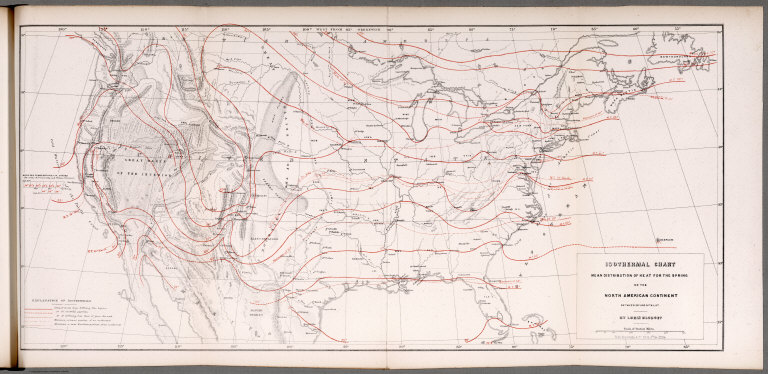
Author
Blodget, Lorin
Full Title
Isothermal chart: Mean distribution of heat for the Spring on the North American Continent; between 25 (degrees) and 50 (degrees) N. Lat. By Lorin Blodget. Fred Bourquin & Co., 50 S. 3rd. St. Phila. (to accompany) Climatology of the United States ...1857.
List No
0083.015
Note
Shows average Spring temperature by isothermal lines.. Isothermal lines shown in red. Includes: "Explanation of isothermals", and table of Mean sea temperature in Spring. Shows principle cities, rivers, mountains, etc. Relief shown by hachures.
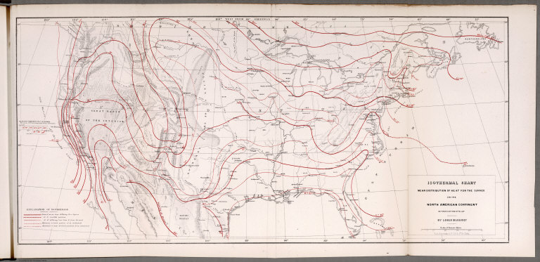
Author
Blodget, Lorin
Full Title
Isothermal chart: Mean distribution of heat for the Summer on the North American Continent; between 25 (degrees) and 50 (degrees) N. Lat. By Lorin Blodget. Fred Bourquin & Co., 50 S. 3rd. St. Phila. (to accompany) Climatology of the United States ...1857.
List No
0083.016
Note
Shows average Summer temperature by isothermal lines. Isothermal lines shown in red. Includes: "Explanation of isothermals", and table of Mean sea temperature in Summer. Shows principle cities, rivers, mountains, etc. Relief shown by hachures.
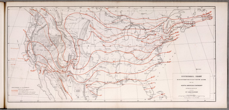
Author
Blodget, Lorin
Full Title
Isothermal chart: Mean distribution of heat for the Autumn on the North American Continent; between 25 (degrees) and 50 (degrees) N. Lat. By Lorin Blodget. Fred Bourquin & Co., 50 S. 3rd. St. Phila. (to accompany) Climatology of the United States ...1857.
List No
0083.017
Note
Shows average Autumn temperature by isothermal lines. Isothermal lines shown in red. Includes: "Explanation of isothermals". Shows principle cities, rivers, mountains, etc. Relief shown by hachures.
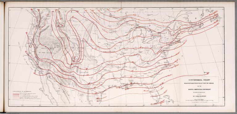
Author
Blodget, Lorin
Full Title
Isothermal chart: Mean distribution of heat for the Winter on the North American Continent; between 25 (degrees) and 50 (degrees) N. Lat. By Lorin Blodget. Fred Bourquin & Co., 50 S. 3rd. St. Phila. (to accompany) Climatology of the United States ...1857.
List No
0083.018
Note
Shows average Winter temperature by isothermal lines. Isothermal lines shown in red. Includes: "Explanation of isothermals". Shows principle cities, rivers, mountains, etc. Relief shown by hachures.
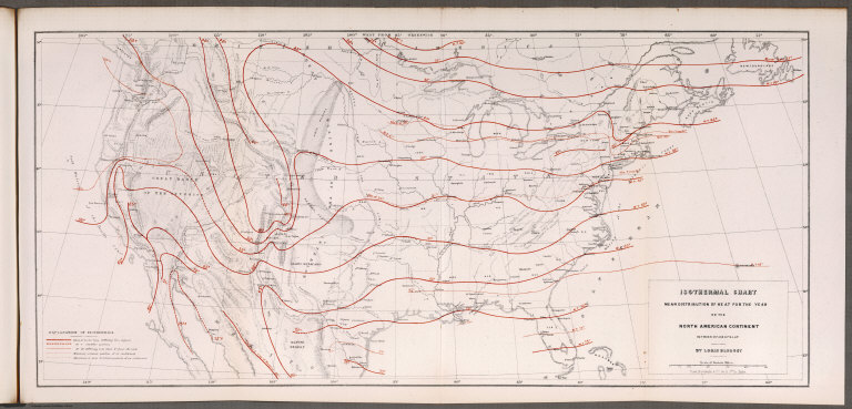
Author
Blodget, Lorin
Full Title
Isothermal chart: Mean distribution of heat for the year on the North American Continent; between 25 (degrees) and 50 (degrees) N. Lat. By Lorin Blodget. Fred Bourquin & Co., 50 S. 3rd. St. Phila. (to accompany) Climatology of the United States ...1857.
List No
0083.019
Note
Shows average annual temperature by isothermal lines.Isothermal lines shown in red. Includes: "Explanation of isothermals". Shows principle cities, rivers, mountains, etc. Relief shown by hachures.
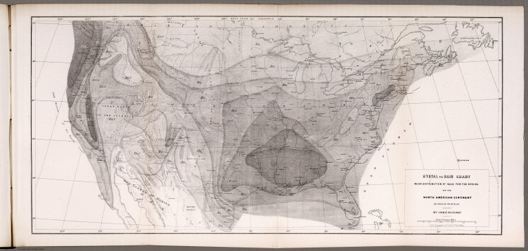
Author
Blodget, Lorin
Full Title
Hyetal or rain chart: Mean distribution of rain for the Spring on the North American Continent; between 25 (degrees) and 50 (degrees) N. Lat. By Lorin Blodget. Fred Bourquin & Co., 50 S. 3rd. St. Phila. (to accompany) Climatology of the United States ...1857.
List No
0083.020
Note
Uncolored seasonal rain map. Showing general distribution of rainfall in inches in Spring over North America. Shows principle cities, rivers, mountains, etc. Relief shown by hachures.
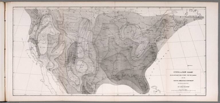
Author
Blodget, Lorin
Full Title
Hyetal or rain chart: Mean distribution of rain for the Summer on the North American Continent; between 25 (degrees) and 50 (degrees) N. Lat. By Lorin Blodget. Fred Bourquin & Co., 50 S. 3rd. St. Phila. (to accompany) Climatology of the United States ...1857.
List No
0083.021
Note
Uncolored seasonal rain map. Showing general distribution of rainfall in inches in summer over North America. Shows principle cities, rivers, mountains, etc. Relief shown by hachures.
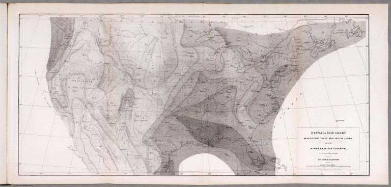
Author
Blodget, Lorin
Full Title
Hyetal or rain chart: Mean distribution of rain for the Autumn on the North American Continent; between 25 (degrees) and 50 (degrees) N. Lat. By Lorin Blodget. Fred Bourquin & Co., 50 S. 3rd. St. Phila. (to accompany) Climatology of the United States ...1857.
List No
0083.022
Note
Uncolored seasonal rain map. Showing general distribution of rainfall in inches in Autumn over North America. Shows principle cities, rivers, mountains, etc. Relief shown by hachures.
Author
Blodget, Lorin
Full Title
Hyetal or rain chart: Mean distribution of rain for the Winter on the North American Continent; between 25 (degrees) and 50 (degrees) N. Lat. By Lorin Blodget. Fred Bourquin & Co., 50 S. 3rd. St. Phila. (to accompany) Climatology of the United States ...1857.
List No
0083.023
Note
Uncolored seasonal rain map. Showing general distribution of rainfall in inches in Winter over North America. Shows principle cities, rivers, mountains, etc. Relief shown by hachures.
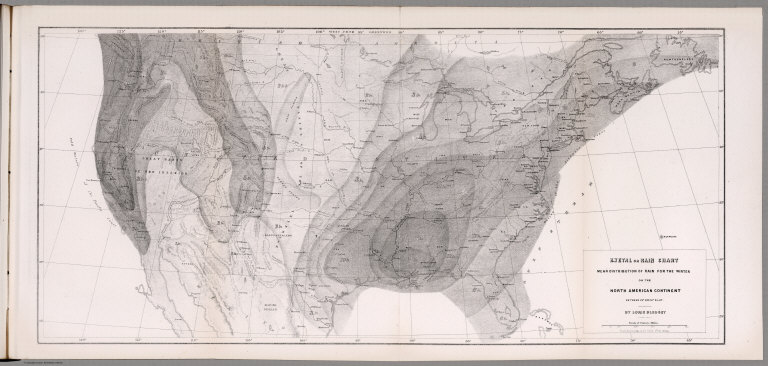
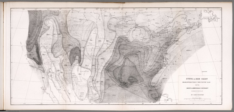
Author
Blodget, Lorin
Full Title
Hyetal or rain chart: Mean distribution of rain for the year on the North American Continent; between 25 (degrees) and 50 (degrees) N. Lat. By Lorin Blodget. Fred Bourquin & Co., 50 S. 3rd. St. Phila. (to accompany) Climatology of the United States ...1857.
List No
0083.024
Note
Uncolored seasonal rain map. Showing general distribution of rainfall in inches in year over North America. Shows principle cities, rivers, mountains, etc. Relief shown by hachures.
Author
Bradford, Thomas G.
Full Title
North America. Entered ... 1838, by T.G. Bradford ... Massachusetts. Engraved by G.W. Boynton.
List No
0089.002
Note
Map in full color.
Author
Brue, Adrien Hubert, 1786-1832
Full Title
Carte generale de l'Amerique Septentrionale, et des iles qui en dependent. Par A. Brue, Geographe du Roi. Paris, 1825. Chez l'Auteur, rue des Macons Sorbonne, no. 9, et chez les principaux m(archan)ds de cartes geographiques.
List No
0096.058
Note
Hand colored engraved map. Relief shown by hachures. Prime meridian: Paris.
Author
Brue, Adrien Hubert, 1786-1832
Full Title
Carte generale des Etats-Unis, du Canada et d'une partie des pays adjacents; par A. Brue, Geographe du Roi. Paris, 1825. Chez l'Auteur, rue des Macons-Sorbonne, no. 9, et chez les principaux marchands de geographie.
List No
0096.059
Note
Hand colored engraved map. Relief shown by hachures. Covers also Northern Mexico. Shows states, Indian tribes, etc. Prime meridian: Paris.
Author
Brue, Adrien Hubert, 1786-1832
Full Title
Carte generale des Etats-Unis Mexicains et des Provinces-Unies de l'Amerique Centrale. (with) Guatemala ou Provinces-Unies de l'Amerique Centrale. Redigee par Brue, Geographe. Paris, 1825. Chez l'Auteur, rue des Macons-Sorbonne, no. 9, et chez les principaux m(archan)ds de cartes geographiques.
List No
0096.060
Note
Hand colored engraved map. Relief shown by hachures. Prime meridian: Paris. Central America shown in inset.
Full Title
Carte geographique, statistique et historique de l'Amerique. Amerique Sept. Grave par B. Beaupre, Rue de Vanguard No. 81. Amerique Merid. ... Fonderie et Imprimerie de J. Carez. (1825)
List No
0102.001
Note
Two hand colored engraved maps. Relief shown by hachures. Text and tables at sides and bottom. Prime meridians: Washington and Paris.
Full Title
Pantographie de l'histoire d'Amerique, ou description de la situation relative des etats et colonies de l'Amerique, depuis sa decouverte jusqu'a l'annee 1825. Fonderie et Imprimerie de J. Carez.
List No
0102.002
Note
Hand colored engraved table. Includes column of text at right.
Full Title
Carte geographique, statistique et historique de l'Amerique Septentrionale. Amerique Septentrionale. Grave par B. de Beaupre, Rue de Vaugirard No. 81, a Paris. Fonderie et Imprimerie de J. Carez. (1825)
List No
0102.003
Note
Hand colored engraved map. Relief shown by hachures. Text at sides and bottom. Prime meridians: Washington and Paris.
Author
[Carey, H. C., Lea, I.]
Full Title
Geographical, Statistical, And Historical Map Of North America. North America. No. 3. Drawn by J. Finlayson. Engraved by J. Yeager.
List No
0122.002
Note
In full color by country with surrounding text.
Full Title
North America. Philad., Published by M. Carey & Son, 1820. (1825)
List No
0124.012
Note
Engraved map. Relief shown pictorially.
Author
Cartee, Cornelius S.
Full Title
Map of North America. Designed To Accompany Cartee's "Elements Of Physical Geography. Engraved by G.W. Boynton. Entered ... 1856, by Hickling, Swan, And Brown ... Massachusetts. (to accompany) A School Atlas Of Physical Geography ... By Cornelius S. Cartee, A.M. M DCCC LVI.
List No
0129.006
Note
Hand color map. Includes explanation. Shows regions, cities, rivers. Relief shown by hachures and spot heights. Prime meridian is Greenwich.
Author
Colton, G.W.
Full Title
North America. Published by J.H. Colton And Co. 172 William St. New York. Entered ... 1855 by J.H. Colton & Co. ... New York. No. 2.
List No
0149.011
Note
In full color by state, country or region.
Author
Colton, G.W.
Full Title
Colton's North America. Published by J. H. Colton. No. 172 William St. New York.
List No
0151.016
Note
Map showing United States, British Possessions, Russian America, Alaska, Mexico, Central America, West Indies, Iceland and Greenland. Prime meridians are Greenwich and Washington D. C. Relief shown by hachures.
Author
Colton, G.W.
Full Title
Northern America, British, Russian & Danish Possessions in North America. Published by J. H. Colton. No. 172 William St. New York.
List No
0151.017
Note
Relief shown by hachures. Prime meridians are Greenwich and Washington D. C.
Author
Colton, G.W.
Full Title
Colton's Canada East or Lower Canada and New Brunswick. Published By J. H. Colton, No. 172 William St. New York.
List No
0151.018
Note
Map showing the counties in Canada East, including capitals and population in 1861. Prime Meridian is Washington D. C. Relief shown by hachures.
Author
Colton, G.W.
Full Title
Colton's Canada West or Upper Canada. Published By J. H. Colton. No. 172 William St. New York.
List No
0151.019
Note
Map showing the cities, towns and villages in Upper Canada. Including Toronto, Hamilton, Ottawa, Kingston and London. Prime meridian is Washington D. C. Relief shown by hachures.
Author
Colton, G.W.
Full Title
Colton's United States of America. Published By J. H. Colton. No. 172 William St. New York.
List No
0151.022
Note
Prime meridians are Greenwich and Washington D. C. Relief shown by hachures.
Author
Colton, G.W.
Full Title
Colton's Georgetown and the City of Washington the Capital of the United States of America. Published By J. H. Colton. No. 172 William St. New York.
List No
0151.023
Note
Map showing districts, roads and layout of various buildings. (inset) Smithsonian Institution, The Capital and Washington Monument.
Author
Colton, G.W.
Full Title
Colton's North America. Published by G. W & C. B. Colton & Co., No. 172 William St. New York.
List No
0152.015
Note
Map showing United States, British Possessions, Russian America, Alaska, Mexico, Central America, West Indies, Iceland and Greenland. Prime meridian is Washington D. C. Relief shown by hachures.
Author
Colton, G.W.
Full Title
Northern America. Published by G. W & C. B. Colton & Co., No. 172 William St. New York.
List No
0152.016
Note
Prime meridians are Greenwich and Washington D.C.
Author
Cornell, S. S. (Sarah S.)
Full Title
North America. Designed to accompany Cornell's High school geography. Entered ... 1855, by S.S. Cornell ... Southern District of New York. New York: D. Appleton & Co., 443 & 445 Broadway. (1864)
List No
0197.003
Note
Engraved map. Hand colored. Relief shown by hachures.
Author
Cram, George Franklin
Full Title
North America.
List No
0210.019
Note
Prime meridians Greenwich and Washington.
Author
Delamarche, Felix
Full Title
Amerique Septentrionale ... 1824.
List No
0231.022
Author
La Perouse, Jean-Francois de Galaup, comte de, 1741-1788
Full Title
Carte des cotes de l'Amerique et de l'Asie depuis la Californie jusqu'a Macao, d'apres les decouvertes faites en 1787 et 1787 par les Fregates Francaises la Boussole et l'Astrolabe. P.F. Tardieu sculp. Atlas du Voyage de la Perouse no. 15. (Paris: Depot-general de la Marine, 1828)
List No
0233.003
Note
Engraved map. Relief shown by hachures and pictorially. Shows route of La Perouse. Prime meridian: Paris. No. 288, 2.
Author
Vancouver, George, 1757-1798
Full Title
Carte de la partie de la cote nord-ouest de l'Amerique. Reconnue pendant les Etes de 1792, 1793 et 1794 depuis 29054' de latitude nord et 244033' de longitude orientale, jusqu'a au Cap Douglas par 58052' de latitude et 207020' de longitude, par le Capitaine Georges Vancouver commandant la Decouverte et le Chatham; avec les routes de ces deux batimens; Redigee par le Lieutenant Edward Roberts d'apres les reconnaissances et les observations. Voyage de Vancouver. No. 3. (Paris: Depot-general de la Marine, 1828)
List No
0233.004
Note
Engraved map. Relief shown by hachures and pictorially. Covers the coast from western Alaska to northern Mexico. Full lines show the vessels' tracks north, with dotted lines showing the vessels' tracks south. Note below cartouche: Les cotes sans ombres dans l'est du Cap decision sout tirees des cartes Espagnoles; Les cotes sans ombres dans l'ouest de l'Ile St. Hermogene sone tirees des cartes Russes.
Author
[Diercke, Carl, Gaebler, Eduard]
Full Title
Nord-Amerika: Meersgebiete. Vegetationsgebiete. (to accompany) Diercke Schul-Atlas fur hohere Lehranstalten. "14" on the lower right margin.
List No
0243.039
Note
Two color map on 2 pages. Prime meridian is Greenwich.
Author
[Diercke, Carl, Gaebler, Eduard]
Full Title
Nord-Amerika: Diercke u. Gaebler, Schulatlas fur hohere Lehranstalten. Druck und Verlag : Braunschweig, George Westermann.
List No
0243.040
Note
Color map on 2 pages. Relief shown by hachures and spot heights. Prime meridian is Greenwich.
Author
[Diercke, Carl, Gaebler, Eduard]
Full Title
Nord-Amerika: Temperaturkarte. Regenkarte. Volkerkarte. Bevolkerungsdichte und wichtige Verkehrswege. (to accompany) Diercke Schul-Atlas fur hohere Lehranstalten. "15" on the lower right margin.
List No
0243.041
Note
4 color maps on 2 pages. Prime meridian is Greenwich.
Author
[Diercke, Carl, Gaebler, Eduard]
Full Title
Nord-Amerika, staatenkarte. Diercke u. Gaebler, Schulatlas fur hohere Lehranstalten. Druck und Verlag : Braunschweig, George Westermann.
List No
0243.042
Note
Color map on 2 pages. Shows international boundaries. Relief shown by hachures. Prime meridian is Greenwich.
Author
[Diercke, Carl, Gaebler, Eduard]
Full Title
Nord-Amerika. Kulturkarte. Industrie u. wichtige produkte. Verbreitung der Neger u. Indianer. Verbreitung der Deutschen. (with 8 insets). (to accompany) Diercke Schul-Atlas fur hohere Lehranstalten. "16" on the lower right margin.
List No
0243.043
Note
Four color maps with 8 insets on 2 pages. Includes cultural map, industrial products map, dissemination of African American and Indian population map, and German settlements in north America map. Relief shown by hachures. Prime meridian is Greenwich.
Author
[Dower, John, Higgins, W.M.]
Full Title
North America.
List No
0247.112
|