|
Author
Finley, Anthony
Full Title
North America. Young & Delleker Sc. Published by A. Finley, Philada. (to accompany) A New General Atlas Comprising a Complete Set of Maps, representing the Grand Divisions Of The Globe ... Philadelphia: Published by Anthony Finley. 1827.
List No
0282.008
Note
Full color map by country on sheet 35x27. Relief shown pictorially. Prime meridian is Greenwich. Shows major cities, capitals, rivers and ports.
Author
[Wytfliet, Corneille, Magini, Giovanni Antonio]
Full Title
Granata Nova et California. (to accompany) Histoire universelle des Indes occidentales et orientales, et de la conversion des Indiens : divisee en trois parties par Cornille Wytfliet & Anthoine Magin & autres historiens. Premiere Partie. A Douay, Chez Francois Fabri, l'An 1611.
List No
11622.048
Note
Uncolored engraved double page map of California, Baja California the Southwestern U.S. Includes decorative title cartouche. Shows the coast of California, cities, towns, landmarks, rivers and mountains. Relief shown pictorially.
Author
[Wytfliet, Corneille, Magini, Giovanni Antonio]
Full Title
Florida et Apalche. (to accompany) Histoire universelle des Indes occidentales et orientales, et de la conversion des Indiens : divisee en trois parties par Cornille Wytfliet & Anthoine Magin & autres historiens. Premiere Partie. A Douay, Chez Francois Fabri, l'An 1611.
List No
11622.055
Note
Uncolored engraved double page map of Florida and the Southeast Coast of North America, part of Cuba and Bahamas. Shows cities, towns, landmarks, rivers, forests and mountains. Relief shown pictorially. Includes decorative title cartouche.
Author
[Wytfliet, Corneille, Magini, Giovanni Antonio]
Full Title
Norumbega et Virginia. (to accompany) Histoire universelle des Indes occidentales et orientales, et de la conversion des Indiens : divisee en trois parties par Cornille Wytfliet & Anthoine Magin & autres historiens. Premiere Partie. A Douay, Chez Francois Fabri, l'An 1611.
List No
11622.058
Note
Uncolored engraved double page map ofthe eastern coastline of North America, from S. Pietro" south to "Buelta de Arenas. Shows cities, towns, landmarks, rivers, forests and mountains. Relief shown pictorially. Includes decorative title cartouche.
Author
Sanson, Nicolas, 1600-1667
Full Title
Americque Septentrionale. Par le Sr. Sanson d' Abbeville, Geographe Ordinaire du Roy ... 1657. A. Peyrouin, sculp. (to accompany) L'Amerique en plusieurs cartes, & en divers traitte's de geographie et d'histoire. A Paris chez l'Autheur.
List No
11576.008
Note
Copper engraved double page map of North America with California as an Island, hand colored in outline, with decorative cartouche, engraved by A Peyrounin. Covers all of North America from Baffin Bay and Greenland, to Central America in the south. Showing political and administrative boundaries, major cities, towns, villages, rivers, mountains, etc. Relief shown pictorially.
Author
Sanson, Nicolas, 1600-1667
Full Title
Le Canada, ou Nouvelle France &c. : tiree de diverses relations des Francois, Anglois, Hollandois, &c. Par N. Sanson d'Abbeville, Geographe ordre du Roy ... 1657. (to accompany) L'Amerique en plusieurs cartes, & en divers traitte's de geographie et d'histoire ... A Paris chez l'Autheur.
List No
11576.012
Note
Copper engraved double page map of Canada and the Great Lakes. Showing political and administrative boundaries, major cities, towns, villages, rivers, mountains, drainage, etc. Relief shown pictorially.
Author
A.J. Nystrom and Company
Full Title
Mid-America panorama. A. J. Nystrom Sc Co., subsidiary of Field Enterprises, Inc. Chicag.
List No
11556.000
Note
Panoramic view of the landforms of North America. With eye holes to hang, was probably used in a school room. Shows major cities, mountains, rivers, and lakes. Relief shown by shading and gradient tints. Map number: "9IMP556." Date estimated.
Author
[Pages, Pierre Marie François, 1748-1793, Bernard, Robert]
Full Title
Carte d'une partie de l'Amerique Septentrionale : qui contient partie de la Nle. Espagne, et de la Louisiane, pour servir aux voyages au tour du Monde et vers les deux Poles, faits par M. de Pages ... ; Benard direxit. (to accompany) Atlas Les voyages de Pages (from ) Pages' Voyages autour du Monde, et vers les deux Poles.
List No
11230.003
Note
Uncolored map, showing part of Louisiana, Texas, the Gulf Coast and Mexico. Showing exploration routes, settlements, villages, missions, and rivers. Relief shown pictorially. Includes legend. Pages accompanied the Spanish Governor of Texas on a Journey from New Orleans to Natchitoches and on to San Antonio by way of the Red River in 1767. The book includes a 15 page account of Texas. Humboldt notes Pages' visit to Saltillo in 1767 in his seminal work on New Spain. The map tracks Pages journey from New Orleans to Acapulco, first up the Red River, then overland, identifying a number of Missions and other settlements and Indian Villages in Texas and Louisiana.
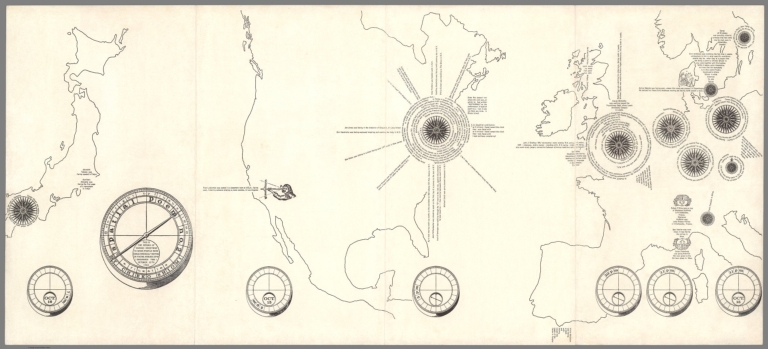
Author
[Shiomi, Mieko, Maciunas, George]
Full Title
(A fluxatlas : Spatial poem). This is the record of various directions to which people were simultaneously moving or facing around 10PM (Greenwich time) October 15th 1965. Mieko Shiomi. Event design, George Maciunas.
List No
11502.000
Note
In 1964 Japanese artist Shoimi Mieko (Chieko) was invited to New York City by George Maciunas, founder of Fluxus network of artists to collaborate with him on a number of projects. This Fluxus map is the 1st. edition uncolored broadside issued in 1966, in 3 folds, with title on the cover "A fluxatlas. Mieko Shiomi. Event design, George Maciunas", now flattened. Includes outline maps of Japan, North America and Europe with notations indicating the locations of artists describing what they were doing at the time. In 1965 Shiomi conducted a series of nine events that she called "Spatial Poems" Each began with invitation to friends and colleagues to respond to a simple instruction, which took the form an intimate action poem, the accumulated responses she received constitute the work and give a glimpse of the network of artists who were connected through Fluxus activities. For Spatial Poem No. 2. Mieko contacted people around the world to record what they were doing and the direction they were facing in the morning Greenwich time on October 15, 1965.
Author
Euler, Leonhard, 1707-1783
Full Title
(Composite map) Mappa geographica Americae Septentrionalis pars I-IV. (to accompany) Atlas geographicus omnes orbis terrarum regiones = Atlas geographique representant en XLI cartes toutes les regions de la terre ... Berolini : Ex officina Michaelis MDCCLIII (1753). (inset: Greenland to New Britain along Baffin Bay and Hudson Bay).
List No
11392.054
Note
Composite map of North America, part 1-4. Hand colored copperplate engraving map on double page 4 sheets. In lower right corner: 3-6. Novell America 1-4. theil.
Author
Palairet, Jean
Full Title
Carte des Possessions Angloises & Francoises du Continent de l'Amerique Septentrionale.
List No
12055.020
Note
Appears to be derived from the John Mitchell Map of the British and French Dominions in North America, 1757 - see our 2842.000. This issue of the Amerique Septentrionale map has the title date changed from 1755 to 1763 in manuscript, and the French possessions are reduced to the Louisiana Territory and islands in the Gulf of St. Lawrence, which might indicate that it was manually updated to show the results of the conclusion of the French and Indian War in 1763. The map was first issued in 1755 and went through several states.
Author
Coronelli, Vincenzo (1650-1718)
Full Title
Video: (Terrestrial Globe)
List No
10070.032
Author
Tanner, Henry Schenck, 1786-1858
Full Title
North America.
List No
12139.008
Author
[Longchamp, Sebastian G., Janvier, Jean Denis]
Full Title
L'Amérique divisée en tous ses pays et etats, dressée sur de nouveaux mémoires et sur les dernières observations.
List No
8683.000
Note
"Important 18th Century wall map of America, one of the earliest obtainable printed maps to show the Sea or Bay of the West and the earliest wall map of America to show this configuration. The map is oriented with east at the top, one of only a few maps to present America in this configuration and unquestionably the largest and most decorative...The map is surrounded by decorative vignettes which depict important events in American History. It is noteworthy for both its decorative quality and early depiction of the Sea or Bay of the West, as well as the curious east at the top projection, which may simply have been a convenience for making the map relatively uniform to the sizes of Longchamp's wall maps of Asia, Africa, and Europe." (Ruderman)
Author
Quad, Matthias, 1557-1613
Full Title
78. Novi orbis pars borealis, America.
List No
9690.164
Author
Tripp, B. Ashburton, 1887-1955
Full Title
Areas of Indian Culture and Principal Tribes in North America.
List No
8640.000
Note
Map of North America showing the locations of over 100 Indian tribes and their division into 9 geographical and cultural groups.
Author
[Seutter, Matthaeus, 1678-1756, Rogg, Gottfried, 1669-1742]
Full Title
Accurata delineatio celeberrimae Regionis Ludovicianae vel Gallice Louisiane ol. Canadae et Floridae Adpellatione in Septemtrionali America Descriptae quae Hodie Nomine Fluminis Mississippi vel St. Louis . . . edita cura et manu Matthaei Seutteri, Chalcog. Augustan. ; Gottfr. Rogg, del. M. Rhein, sc.(inset) "Les costes de la Louisiane depuis la baye de Ascension jusques acelle de S. Joseph.
List No
8155.000
Note
Hand colored map of Seutter's Mississippi Bubble map, depicting the short-lived French financial-colonial scheme masterminded by Scottish financier John Law. Map shows early eighteenth century geography, settlements, and territories in North America focusing on the Mississippi River and the Great Lakes. Relief shown pictorially. Includes historical notes and distant chart. A large inset of the Gulf Coast shows many forts and Indian villages. Elaborate title cartouche, depicts an allegorical, satirical scene of the infamous Mississippi Bubble investment scheme with a female personification of the Mississippi River pouring jewels and riches forth, while she is perched precariously upon a bubble. Cherubs above the cartouche are issuing stock for the company, and another group is blowing bubbles in the foreground surrounded by piles of worthless stocks. In the background, desperate investors climb a small tree and fling themselves out of it, and in the foreground more disconsolate investors wail and bemoan their fates as one tries to impale himself on his sword. Above them, a cherub upends an empty money-bag.
Author
Anville, Jean Baptiste Bourguignon d', 1697-1782
Full Title
Partie occidentale du Canada et septentrionale de la Louisiane avec une partie de la Pensilvanie, Par Le Sr. D'Anville ... A Venise par P. Santini 1775. "Longitude occidentale du premier meridien."
List No
8156.000
Note
Santini's edition of Anville's 1755 map - see our 2603.032, although here as a separate map instead of the Anville formulation as a part of a four sheet map of Canada and Lousiana. Hand colored copper engraving map of the Great Lakes and Upper Mississippi region, extends east to include Lake Ontario, North to James Bay and Southeast to Philadelphia. Shows numerous French forts throughout, along with numerous place and Indian names. Chicagon [sic] is named. Relief shown pictorially. Includes Elaborate title cartouche.
Author
[Godfrey Jr., Joe, Ertz, Gordon (1891-?)]
Full Title
Big Game Fish, Complete Map Illustrated, Fresh and Salt Water Fishing.
List No
8519.000
Note
The pictorial border depicts 56 kinds of fish. Main map has fishermen with a hooked fish on most states. No fisherwomen. Includes records for various fish. Four small round inset maps at the lower left show Panama, the Hawaiian Islands, New Zealand, and Tahiti, with listings of the fish found in those places. Three inset text blocks list: "Famous Fishing Tournaments", "Famous Big Game Fishing Clubs", and "Twenty-two World-famous Places to Go Fishing".
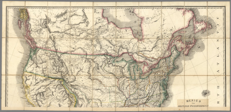
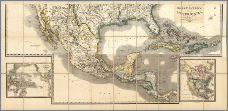
Author
Wyld, James, 1812-1887
Full Title
(Covers to) Mexico The British Possessions In North America And The United States. London. Published By Jas. Wyld, Geographer To The Queen, Charing Cross East. 1846. James Wyld, Geographer to the Queen and to H.R.H. Prince Albert, Charing Cross, East, four doors from Trafalgar Square, London ... (inset) North America. (inset) Islands in the Pacific Ocean.
List No
2747.001
Note
Dissected in north and south sheets, each in 30 sections. This map is a reduction and reissue of Wyld's famous 1824 Map of North America (Stevens and Tree 63 - four editions from 1824 to 1856) - it does not have the top sheet showing the Arctic, it moves the title from the lower left to middle right (and changes title of course), and it updates some of the western geography, showing the Tule Lakes in California, Fremont's or South Pass, Fts Hall and Boise and the Oregon Trail. However, it keeps the outdated topography of the Great Basin and California used in the 1824 edition - the two large rivers running from the interior of the basin to the Pacific, and the mountain ranges running almost east to west instead of north to south in the basin. Nonetheless, it is a very beautiful map in the best of Wyld's cartographic style. Two insets in the lower right and left, of North America and Islands in the Pacific Ocean (both of which appear in the small General Atlas). Map comes from the family of Kit Carson's clerk. Has paste down catalogue. Wheat 658 (1849) is listed in our copy of Radford's Catalogue, 1975. Though smaller, it is likely derived from this map. With outline color. Sheets fold with marbled end sheets into original brown cloth slip case 25x15.5 with label reading "Canada Mexico &c. United States" (ms) and "James Wyld, Geographer To Her Majesty. Charing Cross, East ..."
Author
Wyld, James, 1812-1887
Full Title
(North Sheet) Mexico The British Possessions In North America And The United States. London. Published By Jas. Wyld, Geographer To The Queen, Charing Cross East. 1846. James Wyld, Geographer to the Queen and to H.R.H. Prince Albert, Charing Cross, East, four doors from Trafalgar Square, London ... (inset) North America. (inset) Islands in the Pacific Ocean.
List No
2747.002
Note
Dissected in north and south sheets, each in 30 sections. This map is a reduction and reissue of Wyld's famous 1824 Map of North America (Stevens and Tree 63 - four editions from 1824 to 1856) - it does not have the top sheet showing the Arctic, it moves the title from the lower left to middle right (and changes title of course), and it updates some of the western geography, showing the Tule Lakes in California, Fremont's or South Pass, Fts Hall and Boise and the Oregon Trail. However, it keeps the outdated topography of the Great Basin and California used in the 1824 edition - the two large rivers running from the interior of the basin to the Pacific, and the mountain ranges running almost east to west instead of north to south in the basin. Nonetheless, it is a very beautiful map in the best of Wyld's cartographic style. Two insets in the lower right and left, of North America and Islands in the Pacific Ocean (both of which appear in the small General Atlas). Map comes from the family of Kit Carson's clerk. Has paste down catalogue. Wheat 658 (1849) is listed in our copy of Radford's Catalogue, 1975. Though smaller, it is likely derived from this map. With outline color. Sheets fold with marbled end sheets into original brown cloth slip case 25x15.5 with label reading "Canada Mexico &c. United States" (ms) and "James Wyld, Geographer To Her Majesty. Charing Cross, East ..."
Author
Wyld, James, 1812-1887
Full Title
(South Sheet) Mexico The British Possessions In North America And The United States. London. Published By Jas. Wyld, Geographer To The Queen, Charing Cross East. 1846. James Wyld, Geographer to the Queen and to H.R.H. Prince Albert, Charing Cross, East, four doors from Trafalgar Square, London ... (inset) North America. (inset) Islands in the Pacific Ocean.
List No
2747.003
Note
Dissected in north and south sheets, each in 30 sections. This map is a reduction and reissue of Wyld's famous 1824 Map of North America (Stevens and Tree 63 - four editions from 1824 to 1856) - it does not have the top sheet showing the Arctic, it moves the title from the lower left to middle right (and changes title of course), and it updates some of the western geography, showing the Tule Lakes in California, Fremont's or South Pass, Fts Hall and Boise and the Oregon Trail. However, it keeps the outdated topography of the Great Basin and California used in the 1824 edition - the two large rivers running from the interior of the basin to the Pacific, and the mountain ranges running almost east to west instead of north to south in the basin. Nonetheless, it is a very beautiful map in the best of Wyld's cartographic style. Two insets in the lower right and left, of North America and Islands in the Pacific Ocean (both of which appear in the small General Atlas). Map comes from the family of Kit Carson's clerk. Has paste down catalogue. Wheat 658 (1849) is listed in our copy of Radford's Catalogue, 1975. Though smaller, it is likely derived from this map. With outline color. Sheets fold with marbled end sheets into original brown cloth slip case 25x15.5 with label reading "Canada Mexico &c. United States" (ms) and "James Wyld, Geographer To Her Majesty. Charing Cross, East ..."
Author
Wyld, James, 1812-1887
Full Title
(Composite to) Mexico The British Possessions In North America And The United States. London. Published By Jas. Wyld, Geographer To The Queen, Charing Cross East. 1846. James Wyld, Geographer to the Queen and to H.R.H. Prince Albert, Charing Cross, East, four doors from Trafalgar Square, London ... (inset) North America. (inset) Islands in the Pacific Ocean.
List No
2747.004
Note
Composite of north and south sheets. Dissected in north and south sheets, each in 30 sections. This map is a reduction and reissue of Wyld's famous 1824 Map of North America (Stevens and Tree 63 - four editions from 1824 to 1856) - it does not have the top sheet showing the Arctic, it moves the title from the lower left to middle right (and changes title of course), and it updates some of the western geography, showing the Tule Lakes in California, Fremont's or South Pass, Fts Hall and Boise and the Oregon Trail. However, it keeps the outdated topography of the Great Basin and California used in the 1824 edition - the two large rivers running from the interior of the basin to the Pacific, and the mountain ranges running almost east to west instead of north to south in the basin. Nonetheless, it is a very beautiful map in the best of Wyld's cartographic style. Two insets in the lower right and left, of North America and Islands in the Pacific Ocean (both of which appear in the small General Atlas). Map comes from the family of Kit Carson's clerk. Has paste down catalogue. Wheat 658 (1849) is listed in our copy of Radford's Catalogue, 1975. Though smaller, it is likely derived from this map. With outline color. Sheets fold with marbled end sheets into original brown cloth slip case 25x15.5 with label reading "Canada Mexico &c. United States" (ms) and "James Wyld, Geographer To Her Majesty. Charing Cross, East ..."
Author
Gallatin, Albert
Full Title
Carte des Tribus Indiennnes de l'Amerique du Nord : vers 1600 A.D. ;e long de l'Atlantique ; et vers 1800 A.D. a l'Ouest. D'apres un dessin Mr. Gallatin.
List No
6749.000
Note
Map of the Indian Tribes of North America about 1600 A.D. along the Atlantic; & about 1800 A.D. westwardly. This edition is identical to the American edition of Gallatin map (see: Rumsey Historical Map Collection #3388.000), published by the American Antiquarian Society in their Archaeologia Americana, 1838, except for the addition of an area in the middle of map with a double broken line, showing Indian Territory in Oklahoma. "Le Terrotoire definitivement attribue aux Indiens, est indique par le double trail noir pointle." Map is hand colored. Includes color code listing of Indian territories and tribes, rivers, mountains, place names and notes. Great Basin is called "Sandy Desert". Shows J. Smith exploration routes of 1826 and 1827 across the Great Basin. Date estimated.
Author
Mitchell, John
Full Title
Amerique Septentrionale avec les Routes, Distances en miles, Limites et Establissements Francois et Anglais. Par le Docteur Mitchel, Traduit de l'Anglois. A Paris, Par le Rouge Ingr. Geographe du Roy rue des Grands Augustins 1756.
List No
0510.000
Note
1st French edition, 8 sheets. Very interesting French reengraving of Mitchell's map, emphasizing their territorial claims at the expense of the British claims; in particular they add an area of "contestations" between French claims and the English claims.
Author
Popple, Henry
Full Title
(Composite Map of) A Map of the British Empire in America with the French and Spanish Settlements adjacent thereto. by Henry Popple.
List No
5810.043
Note
A composite of all twenty sheets of the Popple Atlas. Sheets with color.
Author
Bradley, Abraham Junior
Full Title
Map of the United States, Exhibiting the Post-Roads, the situations, connexions and distances of the Post-Offices, Stage Roads, Counties & Principal Rivers By Abraham Bradley Junr. Entered ... 2nd day of June1804, by Abraham Bradley Junr. of the District of Columbia. (inset) Map Of North America. (1805)
List No
5812.002
Note
2nd edition or state of this map, with printed date of 1804 but with estimated date of 1805 based on the naming of Michigan Territory which was formed in 1805 The 1804 first edition (see LOC copy) does not name Michigan. Other changes from the first edition include new public surveys on the Indiana Territory and Ohio border and the addition of a Rapids between Jallot Lake and Great Falls on the Red River. Also of note is the coloring of the Lousiana Territory green all the way to the Pacific coast on the inset map of North America. Other copies we have seen show the Lousiana Territory extending only to the Rocky Mountains - the 1809 and the 1812 editions have a dotted line marking the boundary roughly at the Rocky Mountains. This 1805 edition and the 1804 edition do not have such a line north of the the 42nd parallel.
Author
[Tardieu, P.F., Tardieu, P. (Pierre Antoine), 1784-1869]
Full Title
(Composite of) A Map of Louisiana and Mexico. Carte de la Louisiane et du Mexique, Dressee par P. Tardieu fils aine, Gravee par P.A.F. Tardieu pere. Paris 1820. A Paris, chez: P.A.F. Tardieu, Place de l'Estrapade No. 34. C. Piequet, Geographe Graveur, Quai Conti No. 17. J. Goujon, Marchand de Cartes Geographiques, Rue du Bac No. 6. New York. Anthy. Girard , Mercht. Agent for the Author. Ecrit par Richomme.
List No
5838.001
Note
Combined sheet. Relief shown by hachures. Color used to tint boundaries. California and Nevada largely blank. Mount Diablo in San Francisco Bay Area labeled as M. San Juan Baptista.
Author
[Brockhaus, F.A., Leeder, Ehrenfried, Leutemann, Heinrich]
Full Title
Nordamerica.
List No
6819.054
Note
Lavishly illustrated around margins of map with high quality vignettes of animals, structures and people. Relief shown in hachures.
Author
Popple, Henry
Full Title
A Map of the British Empire in America with the French and Spanish Settlements adjacent thereto. by Henry Popple. C. Lempriere inv. & del. B Baron Sculp. To the Queen's Most Excellent Majesty This Map is most humbly Inscribed by Your Majesty's most Dutiful, most Obedient, and most Humble Servant Henry Popple. London Engrav'd by Willm. Henry Toms & R.W. Seale, 1733. (index map) ... W.H. Toms Sculp.
List No
5810.044
Note
This is the flip book reader of this atlas, showing all map pages and allowing turning of the pages.
Author
Arrowsmith, Aaron
Full Title
(Covers to) A Map Exhibiting all the New Discoveries in the Interior Parts of North America Inscribed by Permission To the Honorable Governor And Company Of Adventurers Of England Trading Into Hudson Bay In testimony of their liberal Communications To their most Obedient and very Humble Servant, A. Arrowsmith, Hydrographer to H.R.H. the Prince of Wales. No. 10 Soho Square, January 1st 1795. Additions to 1811. Additions to 1814. London: Published Jan. 1, 1795 by A. Arrowsmith No. 10 Soho Square. Additions to 1802 ...
List No
0032A
Author
Arrowsmith, Aaron
Full Title
A Map Exhibiting all the New Discoveries in the Interior Parts of North America Inscribed by Permission To the Honorable Governor And Company Of Adventurers Of England Trading Into Hudson Bay In testimony of their liberal Communications To their most Obedient and very Humble Servant, A. Arrowsmith, Hydrographer to H.R.H. the Prince of Wales. No. 10 Soho Square, January 1st 1795. Additions to 1811. Additions to 1814. London: Published Jan. 1, 1795 by A. Arrowsmith No. 10 Soho Square. Additions to 1802 ...
List No
0032.001
Note
This issue incorporates the Lewis and Clark discoveries (and other discoveries) and remaps the entire continent west of the Mississippi. The changes between this and the last edition (1811) are monumental. This copy is from the collection of Sir Charles Broke (or Brooke, subsequently Vere). Broke was in Lower Canada with his regiment, the 5th (Northumberland) Regiment of Foot, which was at the battle of Plattsburg in 1814. Later, he was with the Army of Occupation in France, receiving the Waterloo medal despite arriving from Canada too late for the battle (from Manasek). Without color. Dissected into 40 sections and mounted on linen. Folds into a new gray cloth covered box case 29x22x7 with "North America A. Arrowsmith 1814" stamped on the spine in gold.
Author
Robert Sayer and John Bennett (Firm)
Full Title
North America, As Divided amongst the European Powers By Samuel Dunn, Mathematician. London: Printed for Robt. Sayer ... 10 Jany. 1774.
List No
0875.001
Note
Map in outline color by European Power.
Author
Smiley, Thomas T.
Full Title
N. America. Engraved by E.F. Woodward.
List No
0902.003
Note
In full color by country. Black and white vignette of an Indian at Lough Water Gap.
Author
Mitchell, John
Full Title
A Map of the British and French Dominions in North America with the Roads, Distances, Limits and Extent of the Settlements.
List No
2842.000
Note
This is the second edition of this important map, dated 1755 but published in 1757, according to the British Museum. The only change from the first issue is the addition of several panels of interesting text in ocean. The original eight printed sheets of the map are here assembled in two large panels (each with four sheets) each dissected into 36 sections and mounted on linen. Uncolored, as issued. In the sixth line of the first column of the text this issue is referred to as the Second Edition One of the most important maps in American history, it went through five editions (see Stevens). We believe this second edition is scarcer than the other editions as it appears less often on the market. Compare to the first French edition of 1856 (our copy) regarding the conflicting claims of the British and French to American territory.
Author
Popple, Henry
Full Title
(Covers to) A Map of the British Empire in America with the French and Spanish Settlements adjacent thereto. by Henry Popple. C. Lempriere inv. & del. B Baron Sculp. To the Queen's Most Excellent Majesty This Map is most humbly Inscribed by Your Majesty's most Dutiful, most Obedient, and most Humble Servant Henry Popple. London Engrav'd by Willm. Henry Toms & R.W. Seale, 1733. (index map) ... W.H. Toms Sculp.
List No
2874A
Author
Popple, Henry
Full Title
America Septentrionalis. A Map of the British Empire in America with the French and Spanish Settlements adjacent thereto. by Henry Popple. To the Queen's Most Excellent Majesty This Map is most humbly Inscribed by Your Majesty's most Dutiful, most Obedient, and most Humble Servant Henry Popple. W.H. Toms Sculp.
List No
2874.001
Note
Index map in full color with numeric notations indicating location of the accompanying maps. With eighteen inset maps and four views (Fall of Niagara, Mexico [City], Quebec and New York). Note by Edmund Halley at the bottom verifies the accuracy of the map.
Author
Popple, Henry
Full Title
(Composite Map of) A Map of the British Empire in America with the French and Spanish Settlements adjacent thereto. by Henry Popple. C. Lempriere inv. & del. B Baron Sculp. To the Queen's Most Excellent Majesty This Map is most humbly Inscribed by Your Majesty's most Dutiful, most Obedient, and most Humble Servant Henry Popple. London Engrav'd by Willm. Henry Toms & R.W. Seale, 1733.
List No
2874.002
Note
A composite of all twenty sheets of the Popple Atlas. Sheets without color.
Author
Darton, William
Full Title
(Covers to) A New Map of America, Dissected for the Instruction of Youth in Geography. (with) North America, from the Latest Authorities. Engraved by Willm. Darton. No. 58, Holborn Hill. Published Jany. 26, 1814 by Willm. Darton, London.
List No
3407A
Author
Darton, William
Full Title
North America, from the Latest Authorities. Engraved by Willm. Darton. No. 58, Holborn Hill. Published Jany. 26, 1814 by Willm. Darton, London.
List No
3407.001
Note
Very early map puzzle. The map is from Darton's Union Atlas (see our copy, #4767). Map has some color and has obviously faded with some small sections missing from a few pieces.
Author
[Johnson, A.J., Johnson, D. Griffing]
Full Title
Johnson's New Illustrated & Embellished County Map Of The Republics Of North America With The Adjacent Islands & Countries, Compiled Drawn & Engraved From U. States Land & Coast Surveys, British Admiralty & other Reliable Sources. By D. Griffing Johnson, New York & Washington. 1859. Entered ... 1856 by D.G. & A.J. Johnson ... New York. Map Designed by A.J. Johnson. Engraved by D.G. Johnson, J.H. Goldthwait, W.S. Barnard, Wm. Wright, G. Rae Smith, F.H. King, James Duthie, J.L. White. (inset) Johnson's Map Of The World on Mercator's Projection ...
List No
4012.000
Note
Entered in 1856 and first issued in 1857. With an inset map of the World, and views of the U.S. Capital and the Mormon Temple at Salt Lake City, tables of Distances and Statistics from the Census of 1850, and a Note and list of Authorities which reads in part "The part of this Map, between the Mississippi River and Pacific Ocean, was taken (with the consent of Capt. A.A. Humphreys) principally from a map compiled from the following authorities by Lieut. G.K. Warren, Topl Engrs...In the Office of Pacific Rail Road Surveys, War Department." The map referred to must be the 1855 edition (see our copy) of Warren's General Map for the Pacific Railroad Reports. The list of Authorities is almost identical to the list on that map. Also, the map details of the west used in Johnson's map follow the 1855 edition in scope. Karrow lists many issues of this map from 1857 to 1861, with the views varying in each issue, and with Colton taking over as publisher in 1860. See our late Colton edition of 1890 (our #5150). With black top and bottom roller. Full color by county or territory in the U.S. and by state in Central America. Edged in dark blue silk.
Author
Wyld, James, 1812-1887
Full Title
(Covers to) Map of North America from 20 to 80 Degrees North Latitude Exhibiting The recent Discoveries, Geographical and Nautical; Drawn chiefly from the Authorities of M. De Humboldt, Lieutt. Pike, Messrs. Lewis and Clarke, Sir Alexr. MacKenzie, Mr. Hearne, Coll. Bouchette, Captns. Vancouver, Ross, Parry & Franklin, also describing the Boundary Lines between the Territories of Great Britain & Spain with the United States. London, Published by Jas. Wyld, (successor to W. Faden) No. 5, Charing Cross. Geographer to His Majesty; and to H.R.H. the Duke Of York. June 1st 1823.
List No
4087A
Author
Wyld, James, 1812-1887
Full Title
Map of North America from 20 to 80 Degrees North Latitude Exhibiting The recent Discoveries, Geographical and Nautical; Drawn chiefly from the Authorities of M. De Humboldt, Lieutt. Pike, Messrs. Lewis and Clarke, Sir Alexr. MacKenzie, Mr. Hearne, Coll. Bouchette, Captns. Vancouver, Ross, Parry & Franklin, also describing the Boundary Lines between the Territories of Great Britain & Spain with the United States. London, Published by Jas. Wyld, (successor to W. Faden) No. 5, Charing Cross. Geographer to His Majesty; and to H.R.H. the Duke Of York. June 1st 1823.
List No
4087.001
Note
The first edition, listed in Phillips but not by Stevens and Tree or Wheat (both list 1824/25 as the first edition). A large impressive map showing with great accuracy the recent discoveries in the north west passage, but wildly off in the American southwest - Wheat: "a large and beautiful map, excellent in all respects save for its southwestern geography." In the southwest, Wyld adds many mountain ranges that were purely speculative - probably just to fill in blank spaces in the map (unlike Arrowsmith). In northwestern Texas is a curious note on the topography of the area attributed to "Mellish" which is copied from a pre-1822 edition of his large map of the United States. Comparing this edition to the derived map of 1846, "Mexico, the British Possessions...," one sees many changes in the northern areas and few in the southwest. Stevens and Tree list editions of 1824, 1827/8, 1838, and 1851/56. The 1824/25 edition adds a fold out flap of Mexico and Central America (WH copy). With outline color. Map is dissected into 24 sections and mounted on linen. Map folds into a brown marbled paper covered slip case with black leather spine with "Map Of North America" stamped in gilt.
Author
Associated Railway Land Dept of Florida
Full Title
Map of North America and Western Europe showing the direct passenger transportation lines between Europe and the United States, Mexico, the West Indies, Central and South America, also illustrating the geographical position of Florida and location of the railroad, steamboat and steamship lines ... For commerce with other states and the countries south and east of the Gulf of Mexico. Copyright, 1889. Matthews, Northrup & Co. ... (inset map) Western Europe showing railways and steamship routes to America.
List No
4100.002
Note
Relief shown by hachures. Includes text and illus.
Author
[Mitchell, John, Raynal, G.T., Zatta, Antonio]
Full Title
(Title Page to) Storia Dell' America Settentrionale Del Signor Abate Raynal Continuata fino al present, con Carte Geografiche rappresentanti il Teatro della Guerra Civile tra la Gran Bretagna, e le Colonie Unite. A SS. EE. Li Signori Rifoormatori Dello Studio Di Padova. In Venezia, Dalle Stampe Di Antonio Zatta Con Licenza De Superiori, E Privilegio. M. DCC. LXXVIII.
List No
5007A
Note
In addition to a two volume Italian translation of Raynal's History of North America, this book contains the first edition of Zatta's twelve sheet version of Mitchell's Map of North America, plus three other maps: Il Canada, Le Isole di Terra Nuova e Capo Breton, and La Baja D' Hudson. All of these maps appeared also in Zatta's Atlante Novissimo published from 1779-1785. A second edition of the Zatta/Mitchell maps was published in 1791 (see P651). Zatta's version of Mitchell is not an exact or complete copy: the Zatta maps do not cover the far western portions of Mitchell's map, many geographical changes are introduced, and Bermuda is depicted as well as Jamaica., neither of which are shown by Mitchell. A separate map covers Newfoundland and Cape Breton, on the same scale. Maps are hand painted with outline color. Covers are quarter leather light brown marbled paper covered boards with "Raynal. Storia Dell' America Settentrionale. 1778" stamped in gilt on the new leather spine.
Full Title
North America. Published by Lincoln & Edmands, Boston, (1819)
List No
0004.002
Note
Uncolored engraved map. Relief shown pictorially.
Full Title
North America. H. Morse Sc. Published by Lincoln & Edmands, Boston. (1832)
List No
0006.002
Note
Engraved map. Outline hand col. Relief shown pictorially.
Author
Andreas, A. T. (Alfred Theodore), 1839-1900
Full Title
New railroad map of the United States, the Dominion of Canada, Mexico and the West Indies. (Published by the Andreas Atlas Co., Lakeside Building, Chicago, Ills. Engraved & printed by Chas. Shober & Co., Props. of Chicago Lithographing Co.)
List No
0018.012
Note
Hand col. lithographed map. Relief shown by hachures. Title includes view. Prime meridians: Washington and Greenwich.
Author
Appleton, D. & Co.
Full Title
North America. Copyright 1892 by Appleton & Co. (to accompany) The Library Atlas Of Modern Geography ... New York, D. Appleton And Company 1892. (on upper margin) North America 8.
List No
0026.015
Note
Color map. Shows political divisions, regions and major cities, rivers, mountains, forts and fortifications, principal steam routes and distances from place to place. Includes " Divisional maps". Relief shown by hachures and spot heights. Prime meridian is Greenwich.
Full Title
North America. (Boston: Published by Thomas & Andrews. 1812)
List No
0028.029
Note
Engraved map, uncolored. Relief shown by hachures. Shows settlements, rivers, the larger Indian tribes, etc.
|