|
Author
[Ford Motor Company, Geological Survey (U.S.). Topographic Branch]
Full Title
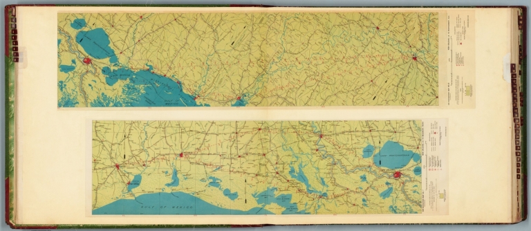
Air navigation map no. 7 (experimental) : New Orleans, La. to Beaumont, Texas. Prepared under the direction of the Airways Section Office of the Chief of Air Corps. By the Topographic Branch, U.S. Geological Survey, revised to July 15, 1927. Engineer Reproduction Plant, U.S. Army, Washington Barracks, D.C. 4915. 1924 - R1927. -- Air navigation map no. 8 (experimental) : New Orleans, La. to Montgomery, Ala. Prepared under the direction of the Airways Section Office of the Chief of Air Corps by the Topographic Branch, U.S. Geological Survey, 1924. Engineer Reproduction Plant, U.S. Army, Washington Barracks, D.C. 4915-8, 1924 - R1927.
List No
14501.006
Note
Two aeronautical charts representing the areas from New Orleans, Louisiana, to Beaumont, Texas, and from New Orleans to Montgomery, Alabama. Features military, municipal, commercial, emergency, and seaplane landing fields. Also shows political boundaries, roads, railways, cities, towns, topography, bodies of water, and drainage. Relief shown with contour lines and color coding. Maps include latitudinal and longitudinal lines, legend, scale statements, and bar scales given in miles, as well as compass roses oriented toward top of sheet (with slight variation between the two maps). Color lithographs. Together, maps are 57 x 114 cm, on double sheet, 60 x 136 cm.
Author
Cram, George Franklin, 1841-1928
Full Title
New Orleans.
List No
14372.302
Note
Map of New Orleans, Louisiana. Shows political boundaries, railroads, streets, bridges, ferry lines, parks, topography, bodies of water and drainage. Relief shown with hachures. Includes a legend, compass rose with north oriented toward top of sheet, as well as a bar scale given in miles. Map indexed to indicate place names. Colored lithograph. Map is 28 x 24 cm, on sheet 45 x 33 cm.
Author
Le Rouge, Georges-Louis, 1712-1790
Full Title
New Orleans. Fort Dauphin.
List No
15542.092
Note
Date estimated. Dimensions are sheet size.
Author
Pittman, Philip, active 1760-1770
Full Title
Plan of New Orleans. No plan yet published like this being its present state. Thos. Kitchin sculp.
List No
14327.013
Note
Map of New Orleans, Louisiana. Shows town plan, roads, topography, parks, vegetation and drainage. Features the shoreline of the Mississippi River. Relief shown with hachures. Indexed to identify particular buildings. Includes a scale statement - "600 ft. to an inch" - and an arrow pointing in the direction of water flow, toward right side of sheet. Black and white engraving. Map is 21 x 29 cm, on fold-out sheet 28 x 42 cm. Accompanied by descriptive text, spanning pages 10-25.
Author
[Grout, Gayle, City Character Print]
Full Title
New Orleans. Illustrated by Gayle Grout. City Character Print, produced and published by Archar Inc. P. O. Box 999 Station U. Toronto, Canada M8Z 5P9 (416)624-5712. © 1983. Printed in the U.S.A. Distributed by Metro News Agency, Inc. 200 Harbor Circle, New Orleans, LA. 70126.
List No
14070.000
Note
Pictorial map of New Orleans, in color bird's-eye view. Shows significant sites and buildings (with names), as well as natural features in the vicinity, such as Lake Pontchartrain. Includes decorative title in the shape of brass instruments, and ornamental border. With descriptive text throughout, e.g.: This house is believed to be haunted. Map is 71 x 92, on sheet 73 x 98 cm.
Author
[Colton, J. H., Norman, B.M., Persac, A.]
Full Title
Norman's Chart Of The Lower Mississippi River By A. Persac. Published by B.M. Norman, New Orleans, La. 1858. Entered ... 1858 by B.M. Norman ... Louisiana. Engraved, Printed & Mounted By J.H. Colton & Co. New York. (At top) From Natchez to New Orleans.
List No
2752.000
Note
Views; shows Plantations by type; very scarce. In full color; lacks original covers. See our reproduction copy issued by Pelican Press, originally in 1931, and printed by Rand McNally - this reproduction greatly alters the original. Ritzlin catalogue: "Persac was a well known surveyor and landscape painter... the map is quite scarce and normally in poor condition because most copies were used by river pilots to locate plantation landings. Few copies are known in contemporary boards. NUC lists only three copies ... however several copies are located in the south, including one which the Louisiana Supreme Court still uses in land ownership cases." Incredible detail, showing the Plantations on both sides of the river. Four engraved views. Engraved by J.H. Colton. Lacking boards, this copy has some tears at the folds with slight loss at some intersections, some light browning in two areas, but is overall a very good copy. Copies at LSU, Historic New Orleans Collection (504-523-4662). See Antiques Magazine, Nov. 1991 for Persac Article. Norman also published "Norman's New Orleans and Environs" with a map of the city, in 1845 (see our copy).
Author
Appleton, D. & Co.
Full Title
Map of New Orleans, Louisiana. Copyright 1891 by Matthews-Northrup Co. ... Buffalo, New York. (to accompany) The Library Atlas Of Modern Geography ... New York, D. Appleton And Company 1892. (on upper margin) New Orleans. 69.
List No
0026.183
Note
Color plan of New Orleans. Shows railways, street car lines, parks, canals, etc. Includes numerical references to Depots, hotels, churches, major buildings, points of interest, parks and cemeteries.
Author
Bradford, Thomas G.
Full Title
Washington. Louisville and Jeffersonville. New Orleans. Cincinnati. Entered ... 1838, by T.G. Bradford ... Massachusetts.
List No
0089.006
Note
Four city maps in full color. The map of Washington includes numbered locations including the Capitol, the State Department, Departments of War, Navy, and the Treasury, as well as the General Post Office.
Author
Colton, G.W.
Full Title
The City Of Louisville Kentucky. (with) The City Of New Orleans Louisiana. Published By J.H. Colton & Co. No. 172 William St. New York. Entered ... 1855 by J.H. Colton & Co. ... New York. No. 34.
List No
0149.040
Note
In full color. Both cities numbered with no reference tables. The two maps are separate but surrounded by the same decorative border.
Author
Colton, G.W.
Full Title
The City of Louisville, Kentucky. The City of New Orleans, Louisiana. Published By J. H. Colton. No. 172 William St. New York.
List No
0151.046
Note
The maps of Louisville and New Orleans are drawn in the same scale.
Author
Colton, G.W.
Full Title
The City of Louisville, Kentucky. The City of New Orleans, Louisiana. Published By J. H. Colton. No. 172 William St. New York.
List No
0152.045
Note
The maps of Louisville & New Orleans are drawn upon the same scale.
Author
Mitchell, Samuel Augustus
Full Title
A New Map Of Louisiana With Its Canals, Roads & Distances from place to place, along the Stage & Steam Boat Routes. (with) New Orleans. Published By S. Augustus Mitchell, N.E. corner of Market & 7th Street Philada., 1846. Entered ... 1846 by H.N. Burroughs ... Pennsylvania.
List No
0537.025
Note
In full color by county with steamboat route distances given.
Author
Mitchell, Samuel Augustus
Full Title
A New Map of Louisiana with its Canals, Roads & Distances from Place to Place along the Stage & Steam Boat Routes. Published By S. Augustus Mitchell. N.E. corner of Market & 7th. Streets. Philada. (inset map) New Orleans.
List No
0545.028
Note
Full color map. Includes explanation chart, and reference to steam boat routes. Prime meridian is Washington D.C. Relief shown by hachures.
Author
Mitchell, Samuel Augustus Jr.
Full Title
Plan of New Orleans. Entered ... 1860 by S. Augustus Mitchell, Jr. ... Pennsylvania.
List No
0572.029
Note
Full color map.
Author
Mitchell, Samuel Augustus Jr.
Full Title
Plan of New Orleans. Entered ... 1867 by S. Augustus Mitchell, Jr. ... Pennsylvania.
List No
0579.030
Note
Color map, showing roads, railroads, etc.
Author
Mitchell, Samuel Augustus
Full Title
Plan of New Orleans. Entered ... 1879 by S. Augustus Mitchell ... Washington. (1880)
List No
0586.028
Note
Hand colored. Shows wards, canals, etc. Oriented with north toward upper right.
Author
Mitchell, Samuel Augustus Jr.
Full Title
Plan of New Orleans. Copyright by S. Augustus Mitchell 1884.
List No
0592.030
Note
Hand colored. Shows wards, canals, etc. Oriented with north toward upper right.
Full Title
Plan of New Orleans. Copyright 1887(?) by Wm. M. Bradley & Bro. (1890)
List No
0594.029
Note
Hand colored. Shows wards, canals, etc. Oriented with north toward upper right.
Author
[Paullin, Charles O., Wright, John K.]
Full Title
Plate 157. Plans of Cities. Charlestown, South Carolina, 1780. Plan of the City of Philadelphia, the Capital of Pennsylvania from an Actual Survey of Benjamin Easburn, Surveyor General, 1776. A Plan of New Orleans & Its Environs (1803) (Facsimiles).
List No
0702.160
Author
Tanner, Henry S.
Full Title
A New Map Of Louisiana With Its Canals, Roads & Distances from place to place, along the Stage & Steam Boat Routes by H.S. Tanner. (with) New Orleans. Engraved by W. Brose, Philadelphia. Entered ... 1833 by H.S. Tanner ... Pennsylvania. Published by H.S. Tanner No. 144 Chesnut St. Philadelphia. (above neat line) Tanner's Universal Atlas.
List No
0977.021
Note
In full color by county with steamboat routes and distances shown in chart form. Inset map of New Orleans includes districts, buildings and cemeteries.
Author
Barnes, Myra Zimmerman
Full Title
Le Vieux Carre de la Nouvelle Orleans. Drawn by Myra Zimmerman Barnes, 1942. "Data from: Old New Orleans, by Stanley Clisby Arthur.
List No
10045.000
Note
Color pictorial map is bordered by color illustrations of places and activities of interest, historical sites, etc., within an attractive ornate ironwork border. Covered with major buildings, coat of arms, activities, streets, etc. Includes descriptive text and seal of State of Louisiana. This issue has a wider range of colors than our other copy, see 8223.000
Author
[Passonneau, Joseph R., Wurman, Richard Saul]
Full Title
New Orleans.
List No
10195.056
Author
[Passonneau, Joseph R., Wurman, Richard Saul]
Full Title
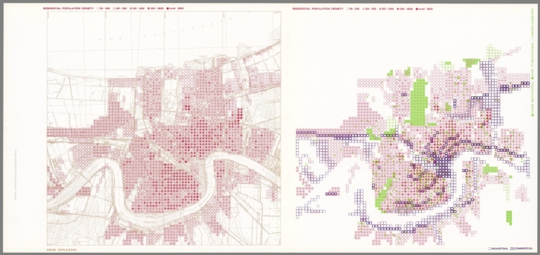
New Orleans. Residential Population Density; Industrial, Commercial; Large Institutional, Park, Institutional, Airport, Cemetery.
List No
10195.057
Author
[Passonneau, Joseph R., Wurman, Richard Saul]
Full Title
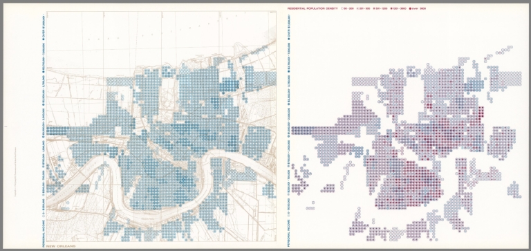
New Orleans. Personal Income; Residential Population Density.
List No
10195.058
Author
Curtis, Nathaniel Cortlandt, 1881-1953
Full Title
The creole city of New Orleans. Founded by Jean Baptiste Le Moyne de Bienville in 1718. Surveyed and planned by Sieur le Blond de la Tour in 1720. A composite view showing the Original City & surrounding Municipalities to which are added some monuments of a later date. Copyright, 1930 by Nathaniel Cortlandt Curtis.
List No
11269.000
Note
Pictorial map in black and white with decorative border. Includes coat of arms in color. Showing building, landmarks, streets,canals, roads, seaports and steamboats. Includes historical notes, texts and decorative title cartouche and compass rose.
Author
[Nirenstein, Nathan, Funk & Wagnalls Company.]
Full Title
(Business Real Estate Locations), New Orleans (Louisiana). Sheet No. 1.
List No
12508.069
Note
Date estimated.
Author
[Nirenstein, Nathan, Funk & Wagnalls Company.]
Full Title
(Business Real Estate Locations), New Orleans (Louisiana). Sheet No. 2.
List No
12508.070
Note
Date estimated.
Author
[Nirenstein, Nathan, Funk & Wagnalls Company.]
Full Title
(Composite Map) (Business Real Estate Locations), New Orleans (Louisiana). Sheets No. 1-2.
List No
12508.071
Note
Date estimated.
Author
[Gillican, Lucille, Andrew, Louis, Funk & Wagnalls Company.]
Full Title
Vieux Carreede la Nouvelle Orleans over a span of many years. A-Map done in the year 1928, by Lucille Gillican and Louis Andrews. Copyright 1929 by Lucille Gillican
List No
13053.000
Note
A pictorial map of the New Orleans French quarter, drawn in 1028 and published in 1029 by Lucile Gillican and Louis Elizabeth Andrews Fischer. Depicts the New Orleans French Quarter or Vieux Carre highlighting historic buildings and New Orleans culture. At the tope and sides of map: views of places, people, historical notes and landmarks. Library has smaller edition of this map, see Pub list no. 8784.000.
Author
Rand McNalley & Company
Full Title
Minneapolis, St. Paul, Minn., and vicinity -- Montreal, Que. -- New Orleans, La. -- Philadelphia, Pa., and vicinity.
List No
14003.059
Note
4 road maps of cities. Maps include compass roses and legends. Copyright by Rand McNally & Company, Chicago, Ill. Lithographed in the U.S.A.
Author
Petri, Girolamo
Full Title
Tav. CXXIX. Provincia ecclesiastica di Nuova Orleans e vicariato pel Territorio Indiano.
List No
14007.315
Note
Hand-colored, engraved map showing the ecclesiastical provinces of New Orleans (Louisiana) and Indian Territory, as well as the greater American South. Text in delicate script circling land. Accompanied by descriptive text on facing page. In Volume III.
Author
[France. Ministère des travaux publics. Administration des routes, France. Direction des cartes, plans et archives et de la statistique graphique, École nationale des ponts et chaussées (France)]
Full Title
La Nouvelle-Orléans. (1886). 4e Série. Pl. VIII. Ministère des Travaux Publics. Ecole des Ponts et Chaussées. Lith. A. Simon, 13, R. du Val-de-Grâce. Paris.
List No
14306.098
Note
Map showing the port of New Orleans, Louisiana, in 1886. Features railways, streets, bridges, drainage and docks. Includes a bar scale and compass rose, with north oriented toward top-right of sheet. Descriptive text throughout. Lithograph in black, white and blue. Map is 29 x 57 cm, on fold-out sheet 33 x 60 cm. Bookplate title pasted to verso: Pl. VIII. La Nouvelle-Orléans. Appears in Quatrième livraison.
Author
Colton, G.W.
Full Title
The City of Louisville, Kentucky. The City of New Orleans, Louisiana. Published by G. W & C. B. Colton & Co., No. 182 William St. New York.
List No
1550.041
Note
The maps of Louisville & New Orleans are drawn in the same scale.
Author
[Colton, G.W., Fisher, Richard Swainson]
Full Title
Mississippi, Louisiana, and Arkansas. (inset) Vicinity of New Orleans.
List No
1690.090
Note
Relief depicted by hachures. Marshland shown.
Author
[Abbot, Henry L., United States. War Department]
Full Title
Department of the Gulf. Map no. 5. Approaches to New Orleans, prepared by order of Maj. Gen. N.P. Banks (by) Henry L. Abbot, Capt. and Chief Top. Engrs., Feb. 14th, 1863. (with Fairburn, Ga., Aug. 15-16, 1864). (with) Position of Army of Tennessee near Atlanta, Ga., July 22, 1864. (with) Map of Spanish Fort, Ala., made during the siege by Lieut. J.A. Chalaron ... (with) Diagrams illustrating the different positions occupied by the 4th Division, 17th Army Corps, during the battle of Atlanta, Ga., July 22, 1864. (with) Part of Paulding County, showing the position of the Left Wing, 16th A.C., June 4, 1864. (with) Section of a map showing the lines new New Hope Church, Ga., 1864. From Chief Engineer's Office, Army of Mississippi, by Capt. W.J. Morris, Chief Engineer. (with) Topographical sketch of the position of the Second Division, 14th Army Corps, in front of Savannah, Ga., December 11th, 1864. Brig. Gen. Jas. D. Morgan, commanding Division. Surveyed and drawn by Chas. Petri ... (with) Map of the vicinity of Mechanicsville, Va. (with Spanish Fort, Ala., March 29-April 8, 1865. Chas. G. Johnson). (with) Spanish Fort, 1865. Drawn during siege by assistant surgeon Bull, C.S. Army. Julius Bien & Co., Lith., N.Y. (1891-1895)
List No
1780.090
Note
Col. map with 10 ancillary maps. Accompany reports or letters of J. Kilpatrick, Giles A. Smith, J.M. McPherson and T. Seymour.
Author
Colton, G.W.
Full Title
The City of Louisville, Kentucky. The City of New Orleans, Louisiana.
List No
2441.082
Note
2 maps, one sheet.
Author
Mitchell, Samuel Augustus
Full Title
Plan of New Orleans. Entered ... 1870 by S. Augustus Mitchell, Jr. ... Pennsylvania.
List No
2483.026
Note
Hand colored. Shows wards, railroads, etc. Oriented with north toward upper right.
Author
Rand McNally and Company
Full Title
New Orleans.
List No
2790.202
Author
Cram, George Franklin
Full Title
New Orleans.
List No
2809.121
Note
.
Author
Rand McNally and Company
Full Title
Rand, McNally & Co.'s New Orleans.
List No
2844.062
Note
Tables of railroads and chief cities keyed to map.
Author
[Norman, B.M., Moellhausen, Henry]
Full Title
(Covers to) Norman's New Orleans and Environs: Containing a Brief Historical Sketch of the Territory and State of Louisiana, and the City of New Orleans, From the Earliest Period to the Present Time ... With a Correct and Improved Plan of the City ... New Orleans: Published by B.M. Norman. ... 1845. (on verso) Entered ... 1845, by B.M. Norman ... New York.
List No
3413.001
Note
Map is "Norman's Plan of New Orleans & Environs" by Henry Moellhausen. The map was also issued separately in covers (see ad at end of book). Norman published Persac's Chart of the Lower Mississippi River in 1858 (see our copy). Two small maps are included in the text: "New Orleans in 1728" and "Environs of New Orleans." Cloth covered boards with "Norman's New Orleans and Environs" in gilt on cover.
Author
[Norman, B.M., Moellhausen, Henry]
Full Title
Norman's Plan of New Orleans & Environs, 1845 by Henry Moellhausen, Civil Engineer. B.M. Norman, Publisher. Engd. by Shields & Hammond., 2 Camp St., N.O.
List No
3413.002
Note
Map is "Norman's Plan of New Orleans & Environs" by Henry Moellhausen. The map was also issued separately in covers (see ad at end of book). Norman published Persac's Chart of the Lower Mississippi River in 1858 (see our copy). Two small maps are included in the text: "New Orleans in 1728" and "Environs of New Orleans." Cloth covered boards with "Norman's New Orleans and Environs" in gilt on cover.
Author
[Norman, B.M., Moellhausen, Henry]
Full Title
(View of) New - Orleans
List No
3413.003
Note
Map is "Norman's Plan of New Orleans & Environs" by Henry Moellhausen. The map was also issued separately in covers (see ad at end of book). Norman published Persac's Chart of the Lower Mississippi River in 1858 (see our copy). Two small maps are included in the text: "New Orleans in 1728" and "Environs of New Orleans." Cloth covered boards with "Norman's New Orleans and Environs" in gilt on cover.
Author
[Norman, B.M., Moellhausen, Henry]
Full Title
(Title page to) Norman's New Orleans and Environs: Containing a Brief Historical Sketch of the Territory and State of Louisiana, and the City of New Orleans, From the Earliest Period to the Present Time ... With a Correct and Improved Plan of the City ... New Orleans: Published by B.M. Norman. ... 1845. (on verso) Entered ... 1845, by B.M. Norman ... New York.
List No
3413.004
Note
Map is "Norman's Plan of New Orleans & Environs" by Henry Moellhausen. The map was also issued separately in covers (see ad at end of book). Norman published Persac's Chart of the Lower Mississippi River in 1858 (see our copy). Two small maps are included in the text: "New Orleans in 1728" and "Environs of New Orleans." Cloth covered boards with "Norman's New Orleans and Environs" in gilt on cover.
Author
[Norman, B.M., Moellhausen, Henry]
Full Title
New Orleans in 1728
List No
3413.005
Note
Map is "Norman's Plan of New Orleans & Environs" by Henry Moellhausen. The map was also issued separately in covers (see ad at end of book). Norman published Persac's Chart of the Lower Mississippi River in 1858 (see our copy). Two small maps are included in the text: "New Orleans in 1728" and "Environs of New Orleans." Cloth covered boards with "Norman's New Orleans and Environs" in gilt on cover.
Author
[Norman, B.M., Moellhausen, Henry]
Full Title
Environs of New Orleans.
List No
3413.006
Note
Map is "Norman's Plan of New Orleans & Environs" by Henry Moellhausen. The map was also issued separately in covers (see ad at end of book). Norman published Persac's Chart of the Lower Mississippi River in 1858 (see our copy). Two small maps are included in the text: "New Orleans in 1728" and "Environs of New Orleans." Cloth covered boards with "Norman's New Orleans and Environs" in gilt on cover.
Author
Rand McNally and Company
Full Title
Rand, McNally & Co.'s indexed atlas of the world map of New Orleans. Rand, McNally & Co's New business atlas map of New Orleans. Copyright, 1892, by Rand, McNally & Co. (Chicago, 1897)
List No
3565.099
Note
Col. map. Shows major buildings, parks, cemeteries, ferries, etc. Includes inset at reduced scale. Title in margin: Indexed atlas of the world.
Author
Colton, G.W.
Full Title
The City of Louisville, Kentucky. The City of New Orleans, Louisiana.
List No
3800.079
Author
Mitchell, Samuel Augustus Jr.
Full Title
Plan of New Orleans. Entered ... 1874, by S. Augustus Mitchell ... Washington.
List No
3804.030
Note
Hand colored map. Show ward, major public buildings, roads, railroads, etc.
Author
[Johnston, Alexander Keith, 1804-1871, Rogers, Henry Darwin]
Full Title
New Orleans. San Francisco. London ... & according to an act of Congress ... 1857, by H.D. Rogers ... Massachusetts. London, John Murray, Albemarle Street, Edinburgh, W. & A.K. Johnston. Engraved by W. & A.K. Johnston, Edinburgh.
List No
3825.030
Note
Full color in water sections, cities with no color.
|