|
REFINE
Browse All : Images of New Mexico and Texas
1-30 of 30
Author
[Meyer, Joseph, 1796-1856, Grassl, J.]
Full Title
Vereinigte Staaten von Nord-America : Californien, Texas und die Territorien New Mexico u. Utah. Nach den neuesten Hulfsmitteln gezeich von J. Grassl. 1852. (in upper margin) Meyer's Zeitung Atlas. No. 120. (to accompany) Neuester Zeitungs-Atlas fur Alte und Neue Erdkunde. Herausgegeben von J. Meyer.
List No
11652.098
Note
Engraved outline hand color map. Shows administrative boundaries, cities and towns, the gold region in California, Texas truncated by an enlarged New Mexico. Relief shown by hachures. Depth shown by isolines. Prime meridians are Greenwich and Washington.
Author
Arbuckle Bros.
Full Title
Indian Territory, New Mexico, South Dakota, Texas. Copyright 1889 Arbuckle Bros. N.Y.
List No
0027.005
Note
Sheet with maps of four states in full color. "Indian Territory" is now known as Oklahoma. It is noted that, "Of the 41,000,000 acres in the Territory, nearly 26,000,000 have been surveyed and set apart as reservations for the Indians. These have been gathered from all parts of the country, from Oregon to Florida, in pursuance of the general plan of congregating all the Indians in one territory, to be theirs forever." Each card measures 7.5 x 12.5 cm.
Author
[Bartholomew, John, Black, Adam & Charles]
Full Title
Texas, Part of New Mexico. Published by A. & C. Black. Edinburgh. Printed in Colours by Schenck & Macfariane. Edinburgh. Drawn & Engraved by J. Bartholomew, Edinburgh.
List No
0073.017
Note
States outlined in color. Land tinted.
Author
[Bartholomew, John, Black, Adam & Charles]
Full Title
Western States, including California, Oregon, Utah, Washington, New Mexico, Nebraska, Kansas, Indian Territory, &c. Published by A. & C. Black. Edinburgh. Printed in Colours by Schenck & Macfariane. Edinburgh. Drawn & Engraved by J. Bartholomew, Edinburgh.
List No
0073.018
Note
States outlined in color. Land tinted.
Author
Mitchell, Samuel Augustus
Full Title
Map Of Texas From the most recent authorities. (with) Texas North Of Red River. Philadelphia: Published by C.S. Williams N.E. corner of Market & 7th Streets. Entered ... 1845 by C.S. Williams ... Pennsylvania.
List No
0537.036
Note
In full color by county or region.
Author
Mitchell, Samuel Augustus
Full Title
County map of the state of Texas. Showing also portions of the adjoining states and territories. Drawn and engraved by W.H. Gamble, Philadelphia. (with) Plan of Galveston and vicinity. Entered ... 1879 by S. Augustus Mitchell ... Washington. (1880)
List No
0586.029
Note
Hand colored map with inset. Relief shown by hachures. Shows settlements, railroads, etc. Covers also parts of New Mexico and Indian Territory. Prime meridians: Greenwich and Washington.
Author
Mitchell, Samuel Augustus Jr.
Full Title
County map of the state of Texas. Showing also portions of the adjoining states and territories. (with) Plan of Galveston and vicinity. Copyright by S. Augustus Mitchell 1884.
List No
0592.031
Note
Hand colored map with inset. Relief shown by hachures. Shows settlements, railroads, etc. Covers also parts of New Mexico and Indian Territory. Prime meridians: Greenwich and Washington.
Full Title
County map of the state of Texas. Showing also portions of the adjoining states and territories. (with) Plan of Galveston and vicinity. Copyright 1887 by Wm. M. Bradley & Bro. (1890)
List No
0594.030
Note
Hand colored map with inset. Relief shown by hachures. Shows settlements, railroads, etc. Covers also parts of New Mexico and Indian Territory. Prime meridians: Greenwich and Washington.
Author
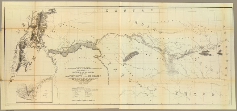
[Ives, J.C., Whipple, A.W.]
Full Title
From Fort Smith to the Rio Grande from explorations and surveys made under the direction of the Hon. Jefferson Davis, Secretary of War by Lieut. A.W. Whipple, Topogl. Engrs. and Lieut. J.C. Ives, Topogl. Engrs. A.H. Campbell, Civil Eng. and Surveyor, Asst. Surveyors: Wm. White Jr., N.H. Hutton, and J.P. Sherburne. 1853-4. Explorations and Surveys for a Rail Road Route from the Missisippi (sic) River to the Pacific Ocean, War Department, Route Near the 35th Parallel, Map No. 1. Engr. by Selmar Siebert.
List No
0693.037
Note
Map begins in the east at Ft. Smith (Arkansas) and continues along the Red River through Texas ending at the Rio Grande in present-day New Mexico. With inset map, "Sketch of the Rio Pecos at Anton Chico."
Author
[Touring club italiano, Funk & Wagnalls Company.]
Full Title
Stati Uniti, United States of America, New Mexico, Oklahoma, Texas. (with New Orleans-Mississippi Delta region). Propr. Artistico-letteraria del T.C.I. Ufficio cartografico del T.C.I. (1929)
List No
1012.077
Note
Color map. Relief shown by hachures and spot heights; depths by isolines. Inset at 1:750,000 scale.
Author
U.S. General Land Office
Full Title
(Map 10 - Texas, New Mexico, Indian Territories, Utah).
List No
1071.012
Note
One of the series of adjacent sixteen maps. Mounted on linen. Relief shown in hachures.
Author
[Black, Adam, Black, Charles]
Full Title
Texas, New Mexico &c.
List No
1585.070
Author
United States. War Department
Full Title
Map of Texas and part of New Mexico, compiled in the Bureau of Topographl. Engrs. chiefly for military purposes. Information on this map furnished by Wm. E. Young, C.E. and compiled under the direction of Maj. D.C. Houston, Chief Engr., Dept. of the Gulf. Accompanying letter of Gen. N.P. Banks ... (with) Plan of the battle-field at New Creek, W. Va., August 4th, 1864. (with) Plan of the battle-field at Pleasant Mills near Cumberland, Md., August 1st, 1864. Made by F.M. Knight. ... Julius Bien & Co., Lith., N.Y. (1891-1895)
List No
1780.054
Note
Col. map with 2 ancillary maps. Relief shown by hachures. Includes table of stations and notes on selected rivers.
Author
Rand McNally and Company
Full Title
(Text Page) Texas. New Mexico.
List No
2094DD
Note
List of geographical features indexed to map.
Author
Vandermaelen, Philippe, 1795-1869
Full Title
Partie du Mexique. Amer. Sep. no. 54. Dressee et dessinee par Ph. Vandermaelen. Dessee. sur pierre et Lithogrie. par H. Ode. Juin 1825. (Quatrieme partie. - Amer. sept. Bruxelles. 1827)
List No
2212.259
Note
Hand col. lithographed map. Relief shown by hachures. Shows Indian tribes, etc. Covers parts of New Mexico, Arizona, Texas, Sonora and Chihuahua.
Full Title
Section along 36th parallel from the Rio Grande to the Canadian Plains. Atlas sheets 69 D and 70 C. Julius Bien, lith. (1881)
List No
2220.078
Note
Lithographed geologic section in 4 segments, sepia toned. Vertical scale not given. Geologic units: Archean, Carboniferous, Jura Trias, Dakota, Colorado, Basalt and Loup Fork.
Author
Carey, Mathew
Full Title
Mexico or New Spain. (with) inset map of southern Mexico and Central America.
List No
2721.034
Note
Countries and states in outline color. Prime meridians Philadelphia and London. Relief shown by hachures. Inset continuation of main map.
Author
Lange, Henry, 1821-1893.
Full Title
Texas. H. Lange's Atlas v. Nord Amerika Blatt XII. Braunschweig: Verlag v. George Westermann. Lith. Anst. von L. Kraatz in Berlin.
List No
2743.012
Note
Engraved map. Borders hand col. Shows roads, post offices, etc. Relief shown by hachures. Covers also "Indian Territory."
Author
Mitchell, Samuel Augustus
Full Title
Map of the state of Texas. Engraved to illustrate Mitchell's school and family geography. Entered ... 1846 by S. Augustus Mitchell ... Eastern District of Pennsylvania.
List No
3559.007
Note
Engraved map. Hand colored. Relief shown by hachures. Covers also present-day Oklahoma and parts of New Mexico, Colorado and Kansas. Shows roads, settlements, counties, Indian tribes, etc. Prime meridians: Greenwich and Washington.
Author
Tanner, Henry S.
Full Title
(Covers to) Map of California New Mexico Texas &c. Published by H.S. Tanner No. 156 Fulton St. New York 1849.
List No
4073A
Author
Tanner, Henry S.
Full Title
Map of California New Mexico Texas &c. Published by H.S. Tanner No. 156 Fulton St. New York 1849.
List No
4073.001
Note
This is taken from Tanner's Map of the United States of Mexico, with the addition of the California Gold Regions colored in yellow, and an added inset map of "United States, Mexico &c. Shewing the Routes from N. York to St. Francisco by Land & Water." The map has been updated to show Fremont's route across the Great Basin and the "Boundary of 1848" with Mexico. The 14x9 cover entitled "Tanner's Travelling Map of California & c has on the inside front a "Table of Routes from New-York to California, with the Modes of Conveyance, Distances, Time and Fares." This is a very late map for Tanner, still printed from engraved plates (although the impression looks a bit tired), in the next to last year of his publishing career. He died in Brooklyn in 1858.
Author
[Morse, Sidney E. (Sidney Edwards), 1794-1871, Breese, S.]
Full Title
A map of the Indian territory : Northern Texas and New Mexico; showing the great western prairies, by Josiah Gregg. Entered ... 1844, by Sidney E. Morse and Samuel Breese ... New-York. (to accompany) Supplement To The New-York Observer. The Cerographic Atlas Of The United States. No.3. 1845.
List No
4180.036
Note
Uncolored map. Shows settlements, towns, villages, forts and trading posts, roads, rivers, etc. Relief shown by hachures. Prime meridians are Greenwich and Washington. Includes note and explanation.
Author
[Morse, Sidney E. (Sidney Edwards), 1794-1871, Breese, S.]
Full Title
A map of the Indian Territory, northern Texas and New Mexico : Showing the great western prairies by Josiah Gregg. Entered ... 1844 by Sidney E. Morse and Samuel Breese ... New York. (New York: Published by Harper & Brothers, 1845). (to accompany) Morse's Cerographic Maps. 1845. No. I.
List No
4861.007
Note
Wax engraved map. Shows towns, Indian villages, forts and fortifications, rivers, ranchos, springs, sandy regions, etc. Covers part of Kansas, Colorado, Oklahoma, and Missouri. Relief shown by hachures. prime meridians are Washington and Greenwich.
Author
U.S. War Department, Topographical Engineers
Full Title
Map of Texas and part of New Mexico compiled in the Bureau of Topgraphl. Eng'rs. chiefly for military purposes, 1857 ... Lith. of Ritchie & Dunnovant. Printed at H.F. Walling's Map Establishment, 90 Fulton St., New York.
List No
5141.000
Note
Probably the best and most detailed military map of Texas issued before the Civil War - rivers, roads, explorer's routes, water holes, forts and towns are shown. Includes "List of authorities." The Warren map of 1857 (see our #4013) incorporates much of this information, with even more information from this map appearing on the Warren map of 1858 (see our #2750). A later version of this map appeared in the Atlas To Accompany The Official Records of the Union and Confederate Armies (see our #1780) as plate 54. Martin and Martin incorrectly state that the map was not published until it appeared in the "Atlas to Accompany..." This is the only government map published by H.F. Walling that we know of. This copy came from a group of about ten copies found with the J.D. Graham papers. Without color. Scarce. Relief shown by hachures.
Author
[Arrowsmith, Aaron, Humboldt, Alexander von, 1769-1859]
Full Title
(A new map of Mexico and adjacent provinces compiled from original documents by A. Arrowsmith, 1810. Sheet 4). London, Published 5th October 1810 by A. Arrowsmith, 10 Soho Square. (Engraved by E. Jones)
List No
5699.013
Note
Engraved map. Outline hand col. Relief shown by hachures. Sheet 4 of 4. Shows settlements, roads, Indian tribes, rivers, etc. Covers parts of the Southwestern U.S.
Full Title
County map of the state of Texas. Showing also portions of the adjoining states and territories. (with) Plan of Galveston and vicinity. Copyright 1886 by Wm. M. Bradley & Bro.
List No
5784.030
Note
Hand colored map with inset. Relief shown by hachures. Shows settlements, railroads, etc. Covers also parts of New Mexico and Indian Territory. Prime meridians: Greenwich and Washington.
Author
Marbut, Curtis F.
Full Title
Soil Map of the United States by Curtis F. Marbut and Associates in the Soil Survery, U.S. Department of Agriculture, F.J. Marschner, Cartographer and Associate in Compilation. 1931. Soils, Plate 5, Section 11. Lith. A. Hoen & Co., Inc. Atlas of American Agriculture.
List No
5797.112
Note
Includes legend of 12 map sections. Includes soils legend for this section and landscape photographs.
Author
Rand McNally and Company
Full Title
(Covers to) Rand, McNally & Co.'s New Shippers' Railroad Map of the United States. Scale: 8 miles to one inch. Showing all railroads, each in a separate color, and all railroad stations in large, plain type. This is the El Paso section only, of the above named map. (Below the neatline) Rand, McNally & Co.'s Shippers' Railway Map of the United States, Copyright, 1891 by Rand, McNally & Co.
List No
5802A
Note
This is the El Paso section of the larger map.
Author
Rand McNally and Company
Full Title
Rand, McNally & Co.'s New Shippers' Railroad Map of the United States. Scale: 8 miles to one inch. Showing all railroads, each in a separate color, and all railroad stations in large, plain type. This is the El Paso section only, of the above named map. (Below the neatline) Rand, McNally & Co.'s Shippers' Railway Map of the United States, Copyright, 1891 by Rand, McNally & Co.
List No
5802.001
Note
This is the El Paso section of the larger map.
Author
Taintor Brothers & Merrill
Full Title
Map of Texas, Indian Territory, Kansas, New Mexico and Arizona.
List No
9731.029
1-30 of 30
|