|
Author
News Map of the Week, Inc.
Full Title
World News of the Week : Monday, Oct. 4, 1943. Covering period Sept. 24 to Sept. 30. Volume 6, No. 5. Published and copyrighted (weekly), 1943, by News Map of the Week, Inc., 1512 Orleans Street, Chicago, Illinois. Published in two sections : Section one. Lithographed in U. S. A.
List No
14151.000
Note
Lithographed world map, in color. Shows political boundaries and military events of World War II, from September 24 to 30, 1943. Relief illustrated with hachures. Descriptive text throughout, e.g.: Fall of Foggia exposes Nazi industry to air attack. Map indexed according to historical notes beneath map. Features photographs, illustrations, and international time zones. With inset map: (New Guinea). Also, with diagram: Saving lives in air war. Map is 56 x 115 cm, on sheet 89 x 120 cm, folded to 31 x 23 cm.
Author
Johnston, Alexander Keith
Full Title
New Zealand. By Keith Johnston, F.R.S.E. Keith Johnston's General Atlas. Engraved, Printed, and Published by W. & A.K. Johnston, Edinburgh & London.
List No
0377.043
Note
Countries and districts outlined in color. Relief shown by hachures. Two scales.
Author
La Perouse, Jean-Francois de Galaup, comte de, 1741-1788
Full Title
Part of the Great Pacific Ocean showing the Route of the Spanish frigate la Princesa commanded by D. Franco. Antonio Maurelle in 1781. Published as the Act directs Novr. 1st ,1798, by G.G. & J. Robinson, Paternoster Row. Neele Sc., Strand. No. 68.
List No
0414.068
Note
Engraved. Meridian Paris.
Author
[Stieler, Adolf, Haack, H.]
Full Title
81. Suedsee-Inseln. (insets) Neu-Zealand. Neu-Guinea. Tasmania. Hawaii Inseln. Tahiti. Fidschi Inseln.
List No
0961.178
Author
[Stieler, Adolf, Haack, H.]
Full Title
Nr. 81. Suedsee-Inseln ... von Dr. H. Haack. Neu Seeland. Neu-Guinea. Tasmania. Tahiti. Hawaii Inseln.
List No
0962.178
Author
[Rossi, Giovanni Giacomo de, 1627-1691, Cantelli, Giacomo, 1643-1695, Rossi, Domenico de, 1647-1729, Widman, Giorgia]
Full Title
Isole dell' India cioe le Molucche, le Filippine e della Sonda : Parte de Paesi di nuoua scoperta e l' Isole de Ladri nel Mare del Zud : descritte da Giacomo Cantelli da Vignola, su l'Esemplare delle carte piu esatte con l'aggion: ta di nuoue notizie cauate da gl'itinerary modernii; e data in luce Da Gio : Giacomo de Rossi alla Pace con Priu. del S. Pont. 1683. Franus Donia Mefsis, Sculp. (To accompany) Mercurio geografico overo Guida geografica in tutte le parti del mondo conforme le tavole di Giacomo Cantelli da Vignola ... Tomo secondo ... l'anno 1692. (Map 178).
List No
11438.158
Note
Outline hand colored Detailed map of Southeast Asia and north coast of Australia, with decorative title cartouche. Relief shown pictorially. Shows administrative divisions, cities, towns, rivers and mountains. Includes notes. Pagination is not continuous, see the index.
Author
[Janssonius van Waesberge, Johannes, Swardt, Dirk Cornelisz, Mercator, Gerhard, 1512-1594, Cloppenburg, Johannes, 1592-1652]
Full Title
Gvineae nova descriptio. Dirck Cornelissen Swardt fecit. (to accompany) Atlas sive Cosmographicae Meditationes de Fabrica mundi et fabricati figura. De novo multis in locis emendatus novisque tabulis auctus. Amsterodami, apud Iohannem Ianssonium van Waesberge. Anno, 1673. ( inset) I. S. Thomae.
List No
11487.173
Note
Copper engraved map of West Africa, . Shows towns, villages, landmarks, mountains, and rivers. Relief shown pictorially.
Author
Meyer, Joseph, 1796-1856
Full Title
Asiatische Archipel und Neu Holland 1849. Stahlstich (Direction v. Kleinknecht) aus der Schweinfurter Geographischen Graviranstalt des Bibliographischen Instituts zu Hildburghausen, Amsterdam, Paris u. Philadelphia. (in upper margin) Meyer's Zeitung Atlas. No. 15. (to accompany) Neuester Zeitungs-Atlas fur Alte und Neue Erdkunde. Herausgegeben von J. Meyer. (insets) Neu-Sud-Wales. (with) Sudwestspitze vom Austram lande.
List No
11652.089
Note
Engraved outline hand color map. Shows political boundaries, cities and towns. Relief shown by hachures. Depth shown by isolines. Includes colored coded European possessions in the region.
Author
[Brue, Andriveau-Goujon, E., Picquet, Chles.]
Full Title
Carte de L'Australie.
List No
12050.055
Author
[Stieler, Adolf, Haack, H.]
Full Title
91. Suedsee-Inseln. Neu-Seeland. Neu-Guinea. Tasmania. Tahiti. Hawaii-Inseln. (Pacific Islands).
List No
12248.191
Author
[Berghaus, Heinrich, 1797-1884, Sohr, Karl, Flemming, Carl]
Full Title
Senegambien, Sudan, Guinea. Druck u. Verlag von C. Flemming in Glogau. (to accompany) Vollstandiger Universal-Handatlas der neueren Erdbeschreibung ,,, Heinrich Berghaus ... 1859.
List No
13250.118
Note
Hand colored in outline map. Relief shown by hachures. Includes color coded key to European possessions.
Author
[Československá akademie věd., Klíma, Jan]
Full Title
Austrálie. Československý vojenský atlas̊.
List No
13684.173
Note
4 maps on 1 sheet. Including New Geania, Southeast Australia and cities: Melbourne and Sydney. Relief shown by gradient tints and spot heights. Depth shown by bathymetric tints, isolines and soundings.
Author
Cassini, Gio. Ma. (Giovanni Maria), 1745-approximately 1824
Full Title
(36) La Nuova Olanda e Nuova Guinea delineate sulle ultime osservazioni. Roma, presso la Calcografia Camerale, 1798.
List No
14000.208
Note
Relief shown pictorially. Includes decorative title cartouche and bar scale. In Volume III.
Author
News Map of the Week, Inc.
Full Title
World News of the Week : Monday, Feb. 15, 1943. Covering period Feb. 5 to Feb. 11. Volume 5, No. 24. Published and copyrighted (weekly), 1943, by News Map of the Week, Inc., 1512 Orleans Street, Chicago, Illinois. Published in two sections : Section one. Lithographed in U. S. A.
List No
14123.000
Note
Lithographed world map, in color. Shows political boundaries and military events of World War II, from February 5 to 11, 1943. Relief illustrated with hachures. Descriptive text throughout, e.g.: Menaced on 3 sides by Reds. Map indexed according to historical notes beneath map. Features photographs, illustrations, and international time zones. With 2 inset maps: (New Guinea) -- Areas in which 48 hour work week was ordered (United States). Also, with 2 diagrams: Rationing calendar -- The British Single-Seater 'Spitfire' ... Map is 56 x 115 cm, on sheet 89 x 120 cm, folded to 31 x 23 cm.
Author
News Map of the Week, Inc.
Full Title
World News of the Week : Monday, Feb. 21, 1944. Covering period Feb. 11 to Feb. 17. Volume 6, No. 25. Published and copyrighted (weekly), 1944, by News Map of the Week, Inc., 1512 Orleans Street, Chicago, Illinois. Published in two sections : Section one. Lithographed in U. S. A.
List No
14160.000
Note
Lithographed world map, in color. Shows political boundaries and military events of World War II, from February 11 to 17, 1944. Relief illustrated with hachures. Descriptive text throughout, e.g.: Reds close in on trapped Nazis. Map indexed according to historical notes beneath map. Features photographs, illustrations, and international time zones. With inset map: (New Guinea, including New Britain Island). Map is 56 x 115 cm, on sheet 89 x 120 cm, folded to 31 x 23 cm.
Author
News Map of the Week, Inc.
Full Title
World News of the Week : Monday, May 1, 1944. Covering period Apr. 21 to Apr. 27. Volume 6, No. 35. Published and copyrighted (weekly), 1944, by News Map of the Week, Inc., 1512 Orleans Street, Chicago, Illinois. Published in two sections : Section one. Lithographed in U. S. A.
List No
14169.000
Note
Lithographed world map, in color. Shows political boundaries and military events of World War II, from April 21 to 27, 1944. Relief illustrated with hachures. Descriptive text throughout, e.g.: New York-to-Ireland speed record set by 30-ton U. S. transport. The time, 15 hours, 51 minutes. Map indexed according to historical notes beneath map. Features photographs, illustrations, and international time zones. With three inset maps: Recapture of Crimea opens new vista -- The war on New Guinea -- The air war against Germany. Map is 56 x 115 cm, on sheet 89 x 120 cm, folded to 31 x 23 cm.
Author
Cram, George Franklin, 1841-1928
Full Title
Map of New Guinea.
List No
14372.359
Note
Map of New Guinea. Shows political boundaries, cities, railroads, topography, bodies of water, drainage, coastlines and islands. Relief shown with hachures. Includes latitudinal and longitudinal lines, as well as a bar scale given in miles. Provides figures for square milage and population. Map indexed to indicate place names. Inset map: Part of South Coast of New Guinea. Colored lithograph. Map is 27 x 42 cm, on sheet 33 x 45 cm.
Author
[Dépôt General de la Marine, Daussy, Pierre, 1792-1860]
Full Title
Carte de la partie du Grand Archipel d'Asie comprise entre Java, la Nouvelle-Guinée et la Nouvelle-Hollande. Dressée par M. Daussy, Ingénieur Hydrographe en Chef, d'après les travaux les plus récents. Publiée par Ordre du Roi sous le Ministère de M. le Baron Duperré, Amiral, Pair de France, Secrétaire d'Etat au Département de la Marine et des Colonies. Au Dépôt-général de la Marine en 1840. Gravé par Chassant. Ecrit par J. M. Hacq.
List No
14392.034
Note
Nautical chart of the waters around the Grand Archipelago of Asia [Indonesia] between Java, New Guinea and New Holland [Australia], surveyed in 1840. Shows cities, ports, topography, bodies of water, drainage, coastlines, shoals, islands, depths and anchorage. Relief shown with hachures. Includes rhumb lines, latitudinal and longitudinal lines, as well as an explanatory note. With table: Table de réduction. Seal: Dépôt Général de la Marine. Black and white engraving. Map is 57 x 92 cm, on double sheet 63 x 93 cm. Created by Daussy, Chief Hydrographic Engineer, according to the most recent work. Published by Order of the King under the Ministry of M. le Baron Duperré, Admiral, Peer of France, Secretary of State in the Department of the Navy and the Colonies. At the Depot-General of the Navy in 1840. "No. 926."
Author
[Dépôt General de la Marine, Vincendon-Dumoulin, C. A. (Clément Adrien), 1811-1858]
Full Title
Carte de la Mer du Corail et des terres environnantes (Nouvelle-Guinée, Iles Salomon, Iles de Santa Cruz, Nouvelles Hébrides, Nouvelle Calédonie et partie de la côte orientale de la Nouvelle-Hollande. Dressée par Mr. C. A. Vincendon Dumoulin, Ingénieur Hydrographe de la Marine, d'après les reconnaissances des Corvettes l'Astrolabe et la Zélée et les travaux les plus récents. Expédition au Pôle Austral et dans l'Océanie, Commandée par M. Dumont d'Urville, Capne. de Vaisseau. 1847. Gravé par Jacobx. Ecrit par J. M. Hacq.
List No
14392.035
Note
Nautical chart of the Coral Sea and surrounding lands (New Guinea, Solomon Islands, Santa Cruz Islands, New Hebrides, New Caledonia and part of the eastern coast of New Holland [Australia], surveyed in 1847. Shows cities, ports, topography, bodies of water, drainage, coastlines, shoals, islands, depths and anchorage. Relief shown with hachures and shading. Includes rhumb lines, latitudinal and longitudinal lines, as well as an explanatory note. Seal: Dépôt Général de la Marine. Black and white engraving. Map is 64 x 88 cm, on double sheet 65 x 95 cm. Created by C. A. Vincendon-Dumoulin, Hydrographic Engineer of the Navy, according to the reconnaissances of the Corvettes the Astrolabe and the Zélée, and the most recent works. Expedition to the Austral Pole and in Oceania commanded by M. Dumont d'Urville, Captain of Vaisseau. Published in 1847. "No. 1155."
Author
[Andree, Richard, Scobel, Albert]
Full Title
Die Wichtigsten Sudseeinseln. Okt. 1905. Neuseeland: Masstab 1:5,000,000. Neu-Guinea und Bismarck-Archipel: Masstab 1:10,000,000. Bearb. v. R. Kocher, E. Umbreit u. R. Endrich. Lithogr. v. C. Muller, W. Ketterer, M. Endlich u. A. Soeder.
List No
1463.112
Note
Outline color maps with 14 insets on 2 sheets. Shows settlements, railways, telegraph cables, etc. Colonies shown in color. Relief shown by hachures and spot heights. Depth shown by bathymetric tints and soundings. Prime meridian is Greenwich.
Author
Bartholomew, John
Full Title
(Index to) New Guinea, Solomons. Mercator Projection. Equatorial Scale, 1:5,000,000.
List No
1552.047
Note
Uncolored index map. Key to adjoining areas.
Author
Bartholomew, John
Full Title
New Guinea, Solomons. Edited by John Bartholomew, M.C., LL.D. The Geographical Institute Edinburgh. Copyright, John Bartholomew & Son, LTD.
List No
1552.048
Note
Full color map. Relief shown by gradient tints and spot heights in feet. Depth shown by shadings and soundings in meter. No. 1591, and Mar. 57, marked on the lower corners of plate. The Times Atlas on the upper left corner. Prime meridian is Greenwich.
Author
USSR (Union of Soviet Socialist Republics).
Full Title
(Map Title Page) 233-234. Australia and Oceania, Physical. 335. New Guinea and Solomon Islands.
List No
1603.244
Author
USSR (Union of Soviet Socialist Republics).
Full Title
335. New Guinea and Solomon Islands. The World Atlas.
List No
1603.246
Author
[Cram, George Franklin, Murray-Aaron, Eugene, 1852-1941.]
Full Title
Map of New Guinea. Published by Geo. F. Cram, Chicago, Ill. (to accompany) Cram's atlas of the world, ancient and modern : new census edition -- indexed. (inset) Part of south coast of New Guinea.
List No
1910.166
Note
Color map. Shows cities, towns, roads, etc. Dutch, German and British possessions shown in different colors. Relief shown by hachures. Prime meridian is Greenwich.
Author
Hammond, C.S.
Full Title
East India Islands. 19.
List No
1954.045
Note
Includes a map of the Netherlands at the same scale as East India Islands.
Author
Vandermaelen, Philippe, 1795-1869
Full Title
Partie de la Nouvelle Guinee. Oceanique no. 22. (Dresse par Ph. Vandermaelen, lithographie par H. Ode. Sixieme partie. - Oceanique. Bruxelles. 1827)
List No
2212.350
Note
Hand col. lithographed map. Relief shown pictorially. Covers northwestern part of New Guinea and parts of the Moluccas. Prime meridian: Paris.
Author
Vandermaelen, Philippe, 1795-1869
Full Title
Partie de la Nouvelle Guinee. Oceanique no. 23. (Dresse par Ph. Vandermaelen, lithographie par H. Ode. Sixieme partie. - Oceanique. Bruxelles. 1827)
List No
2212.351
Note
Hand col. lithographed map. Relief shown by hachures; depths by soundings. Covers north-central New Guinea. Prime meridian: Paris.
Author
Vandermaelen, Philippe, 1795-1869
Full Title
Partie de la Nouvelle Guinee. Oceanique no. 31. (Dresse par Ph. Vandermaelen, lithographie par H. Ode. Sixieme partie. - Oceanique. Bruxelles. 1827)
List No
2212.359
Note
Hand col. lithographed map. Relief shown pictorially and by hachures. Covers coasts of eastern Papua New Guinea, the Trobriand and D'Etrecasteaux islands and southern New Britain. Prime meridian: Paris.
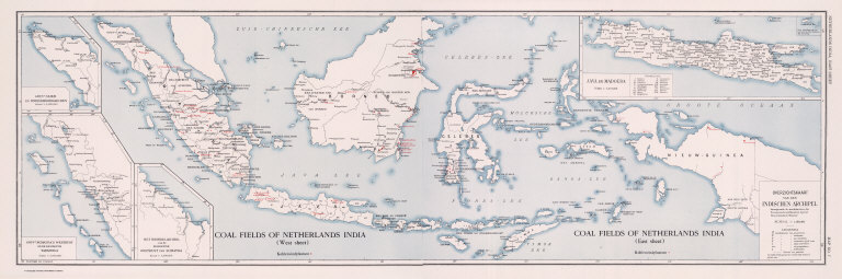
Full Title
Coal Resources of the World. Coal Fields of Netherlands India. (West Sheet) (East Sheet) Overzichtskaart van den Indischen Archipel. Map No. 7.
List No
2249.011
Note
In Dutch.
Full Title
(Composite) Coal Fields of Netherlands India. Overzichtskaart van den Indischen Archipel. Coal Resources of the World. (inset) Gouvt. Atjeh en Onderhoorigheden. (inset) Gouvt. Sumatra's Westkust en de Residentie Tapanoeli. (inset) Het Noordelijk Deel van de Residentie Oostkust van Sumatra. (inset) Java en Madoera.
List No
2249.012
Author
[Jones, C.H., Hamilton, T.H., Williams, J.David]
Full Title
Oceania.
List No
2307.051
Note
Relief shown in hachures.
Author
Johnston, W. & A.K.
Full Title
New Zealand. (with) New Guinea. (with) Wellington. (with) Dunedin and Otago Harbour. (with) Auckland. (with) Chatham Is. Keith Johnston's General Atlas. Sept. 1910. Engraved, Printed, and Published by W. & A.K. Johnston, Limited, Edinburgh & London.
List No
2763.047
Note
Counties outlined in color. Five insets. Relief shown by hachures. Two scales.
Author
Cram, George Franklin
Full Title
Map of New Guinea. (inset) Part of South Coast of New Guinea.
List No
2809.168
Note
Relief shown by hachures. Prime meridians Washington D.C. and Greenwich. Colonial ownership differentiated in full color.
Author
Johnston, Alexander Keith
Full Title
New Zealand. (with) New Guinea. (with) Wellington. (with) Dunedin and Otago Harbour. (with) Auckland. By Keith Johnston, F.R.S.E. Keith Johnston's General Atlas. Engraved, Printed, and Published by W. & A.K. Johnston, Edinburgh & London.
List No
3287.043
Note
Countries and districts outlined in color. One inset. Relief shown by hachures. Two scales.
Author
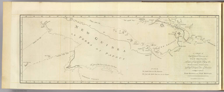
[Carteret, Philip, d. 1796, Hawkesworth, John, 1715?-1773]
Full Title
A chart of Captn. Carteret's discoveries at New Britain, with part of Captn. Cooke's passage thro Endeavor Streights, & of Captn. Dampier's tract & discoveries in 1699, & 1700, at New Guinea and New Britain. Engraved by W. Whitchurch, Pleasant Row, Islington. (London: printed for W. Strahan; and T. Cadell in the Strand, MDCCLXXIII).
List No
3403.016
Note
Engraved nautical chart showing coastal features only. Depths shown by soundings.
Author
Mitchell, Samuel Augustus Jr.
Full Title
Map of New Granada, Venezuela and Guiana. (with insets) Map of Peru, and Equador. (and) Map of the Argentine Confederation. Entered ... 1874, by S. Augustus Mitchell ... Washington.
List No
3804.052
Note
Hand colored map. Shows political divisions, settlements, rivers, etc. Relief shown by hachures. Prime meridians are Greenwich and Washington.
Author
[Black, Adam, Black, Charles, Hall, Sydney]
Full Title
Australasia.
List No
3937.043
Author
[Brue, Adrien Hubert, 1786-1832, Levasseur, E.]
Full Title
Carte Generale de l'Australie, et de la partie Sud-Quest de l'Oceanie. Dresse par A. Brue, Geographe. Reoue par E. Levasseur, Membre de l'Institut, Institut Geographique de Paris. Ch. Delagrave & Cie. Editeurs de la Societe de Geographie. 58 Rue des Ecoles. Atlas Universel en 67 feuilles No. 50. (inset) Iles de Lord Auckland. (inset) (General vicinity of Sydney).
List No
4607.049
Note
Relief shown by hachures. Railroads. Prime meridian Paris. Two scales. Possession shown for England, France, Holland, and Portugal. Electric telegraph lines shown.
Author
Rand McNally and Company
Full Title
(Text Page) Continent of Africa - Governments, Districts, Islands, Lakes, Mountains, Rivers, and Towns. Oceania - Islands, Lakes, Mountains, Rivers and Creeks, and Towns.
List No
5028FY
Note
Geographical features keyed to map; populations of towns.` Relief shown with hachures.
Author
Rand McNally and Company
Full Title
Commercial Atlas of America. Rand McNally Standard Map of Oceania and Malaysia. (with) Eastern Protion of French Polynesia. (with) Hawaiian Is. (with) New Caledonia and Loyalty Islands.
List No
5028.193
Note
Relief shown by hachures.
Author
Rand McNally and Company
Full Title
(Text Page) Philippine Islands. Provinces, Islands, Lakes, Mountains, Mountain Peaks and Volcanoes, Rivers, and Towns.
List No
5028FZ
Note
Geographical features keyed to map; populations of provinces and towns. Relief shown with hachures.
Author
Rand McNally and Company
Full Title
(Text Page) Philippine Islands. Provinces, Islands, Lakes, Mountains, Mountain Peaks and Volcanoes, Rivers, and Towns.
List No
5028GA
Note
Geographical features keyed to map; populations of towns. Relief shown with hachures.
Author
Ruhle von Lilienstern, August
Full Title
Archipel von Neuholland. Berlin 1824. von R.v.L.
List No
5759.030
Note
Shows relief in hachures, hydrography, settlements, and countries outlined in color.
Author
[Bayer, Herbert, Container Corporation of America]
Full Title
Far East. Indonesia. Philippines. New Guinea. (inset) (Djakarta).
List No
5842.127
Note
Map and graphics showing principal resources, population, occupations, manufacturing, mineral production, agriculture, and land use. Includes brief history and description of country's features. Relief depicted by hachures and hypsometric tints.
Author
McGraw-Hill Book Company
Full Title
Oceania Thematic Maps.
List No
6350.038
Author
[Andree, Richard, Times (London, England)]
Full Title
New Guinea and the Papuan Archipelago. (Published at the office of "The Times," London, 1900). (insets) Astrolabe Bay ; Gazelle Peninsula ; Wales.
List No
6809.086
Note
Color map with insets. Shows towns, inhabitants, etc. European possessions shown in color. Relief shown by hachures and spot heights. Prime meridian is Greenwich.
Author
[Codazzi, Agustín, 1793-1859, Paz, Manuel María, 1820-1902]
Full Title
Carta de la Nueva Granada: dividida en provincias; 1832 a 1856; Uti-possidetis de 1810. Grabado por Erhard Hermanos, 8 Calle Nicole, Paris. (to accompany) Atlas geografico e historico de la Republica de Colombia (Antigua Nueva Granada).
List No
6851.030
Note
Color map. Title surrounded by a decorative cartouche. Represent New Granada divided into provinces -1832 to 1855. Shows capitals, capitals of provinces, cities, rivers, etc. Includes explanation. Relief shown by hachures. Prime meridians are Paris, Bogota and Greenwich.
Author
Haack, Hermann
Full Title
Australien und Ozeanien.
List No
7109.000
Note
Language(s): German. Map is paper on muslin. Mounted on wood rods. Prime Meridian is Greenwich. Projection is not specified. Topics include: topography, hydrography, ocean currents . Department of Geography, University of California at Berkeley, Call Number 300-A-1.
Author
Haack Painke
Full Title
Australien und Ozeanien.
List No
7110.000
Note
Suitable for use in a large lecture hall; viewable to and beyond 40 feet. Language(s): German. Map is paper on muslin. Mounted on wood rods. Prime Meridian is Greenwich. Projection is Azimuthal equidistant. Topics include: topography, hydrography, ocean currents, cities/towns, transportation routes, internal/external political boundaries. Department of Geography, University of California at Berkeley, Call Number 300-A-2.
|