|
Author
Rand McNally and Company
Full Title
Rand, McNally & Co.'s New Mexico.
List No
2844.075
Note
Tables of railroads and chief cities keyed to map.
Author
Rand McNally and Company
Full Title
(Text Page) Rand, McNally Co.'s New Mexico. Rand, McNally Co.'s Arizona.
List No
2844DW
Note
Tables of railroads and geographical features keyed to map.
Author
Page, H.R. & Co.
Full Title
Page's Map of New Mexico, 1886.
List No
2861.020
Note
Relief shown by hachures.
Author
Page, H.R. & Co.
Full Title
(View) Greenwood Park. The Chain of Lakes, Waupaca Co., Wis. - Wisconsin Central R.R. (Index Page) Guide to New Mexico.
List No
2871.032
Author
Page, H.R. & Co.
Full Title
Page's Map of New Mexico, 1885. Copyrighted 1880 by H.R. Page.
List No
2871.033
Note
Prime meridians Washington D.C. and Greenwich.
Author
Johnson, A.J.
Full Title
Johnson's California, Territories of New Mexico And Utah By Johnson & Browning. No. 47-48.
List No
2905.031
Note
In full color with Utah, Nevada and New Mexico delineated by broad strips of color. Mail steamship routes shown off the California coast. Routes of the explorers such as Fremont, Gunnison, and Whipple are shown. Emigrant Road is marked by a series of crosses.
Author
Bolitho, Edwin
Full Title
New Mexico. (to accompany) Pocket Mining Atlas. Compiled From The Latest Official Surveys, And The Most Authentic Sources. Edwin Bolitho, Engineering and Mining Journal, New York, 1880. Price, $1.00 per copy. (on following page) Entered ... 1880 ... Washington, D.C., by Trask & Francis, Bankers ... 70 Broadway, New York ...
List No
3054.029
Note
Full color map. Prime meridian is Washington, D.C.
Author
Rand McNally and Company
Full Title
(Covers to) The Rand McNally New Commercial Atlas Map Of New Mexico ... Copyright by Rand McNally & Co. (on verso) New Mexico Automobile Road Map.(with 27 page index) Rand McNally Indexed Pocket Map Tourists' And Shippers' Guide Of New Mexico ... Rand McNally & Company, Chicago 536 South Clark St., New York 42 East 22nd St. (on verso) Copyright, 1920, by Rand McNally & Co., Chicago.
List No
3183.001
Note
The map is from the Commercial Atlas of the U.S. On the verso of the main map is "New Mexico Automobile Road Map" with Auto Roads shown in red on a base map that is the same as the main map. The main map is in full printed color. Covers are brown card board 17x11 printed with "New Mexico. Rand McNally Indexed Pocket Map Tourists' And Shippers' Guide ... Price 35 Cents. Rand McNally & Company ..." Includes index to New Mexico Principal Cities and the list of New Mexico Railroads. The numbers in the list correspond to the numbers on the map. Prime meridian is Greenwich. Relief shown by hachures.
Author
Rand McNally and Company
Full Title
(Title Page to) The Rand McNally New Commercial Atlas Map Of New Mexico ... Copyright by Rand McNally & Co. (on verso) New Mexico Automobile Road Map.(with 27 page index) Rand McNally Indexed Pocket Map Tourists' And Shippers' Guide Of New Mexico ... Rand McNally & Company, Chicago 536 South Clark St., New York 42 East 22nd St. (on verso) Copyright, 1920, by Rand McNally & Co., Chicago.
List No
3183.002
Note
The map is from the Commercial Atlas of the U.S. On the verso of the main map is "New Mexico Automobile Road Map" with Auto Roads shown in red on a base map that is the same as the main map. The main map is in full printed color. Covers are brown card board 17x11 printed with "New Mexico. Rand McNally Indexed Pocket Map Tourists' And Shippers' Guide ... Price 35 Cents. Rand McNally & Company ..." Includes index to New Mexico Principal Cities and the list of New Mexico Railroads. The numbers in the list correspond to the numbers on the map. Prime meridian is Greenwich. Relief shown by hachures.
Author
Rand McNally and Company
Full Title
The Rand McNally New Commercial Atlas Map Of New Mexico ... Copyright by Rand McNally & Co. (on verso) New Mexico Automobile Road Map.(with 27 page index) Rand McNally Indexed Pocket Map Tourists' And Shippers' Guide Of New Mexico ... Rand McNally & Company, Chicago 536 South Clark St., New York 42 East 22nd St. (on verso) Copyright, 1920, by Rand McNally & Co., Chicago.
List No
3183.003
Note
The map is from the Commercial Atlas of the U.S. On the verso of the main map is "New Mexico Automobile Road Map" with Auto Roads shown in red on a base map that is the same as the main map. The main map is in full printed color. Covers are brown card board 17x11 printed with "New Mexico. Rand McNally Indexed Pocket Map Tourists' And Shippers' Guide ... Price 35 Cents. Rand McNally & Company ..." Includes index to New Mexico Principal Cities and the list of New Mexico Railroads. The numbers in the list correspond to the numbers on the map. Prime meridian is Greenwich. Relief shown by hachures.
Author
Rand McNally and Company
Full Title
The Rand McNally New Commercial Atlas Map Of New Mexico ... Copyright by Rand McNally & Co. (on verso) New Mexico Automobile Road Map.(with 27 page index) Rand McNally Indexed Pocket Map Tourists' And Shippers' Guide Of New Mexico ... Rand McNally & Company, Chicago 536 South Clark St., New York 42 East 22nd St. (on verso) Copyright, 1920, by Rand McNally & Co., Chicago.
List No
3183.004
Note
The map is from the Commercial Atlas of the U.S. On the verso of the main map is "New Mexico Automobile Road Map" with Auto Roads shown in red on a base map that is the same as the main map. The main map is in full printed color. Covers are brown card board 17x11 printed with "New Mexico. Rand McNally Indexed Pocket Map Tourists' And Shippers' Guide ... Price 35 Cents. Rand McNally & Company ..." Includes index to New Mexico Principal Cities and the list of New Mexico Railroads. The numbers in the list correspond to the numbers on the map. Prime meridian is Greenwich. Relief shown by hachures.
Author
Clason Map Company
Full Title
(Covers to) Clason's Guide Map Of New Mexico. Published By The Clason Map Co. Denver, Colorado. Copyrighted 1915 by The Clason Map Co. Denver, Colo. 1916 Edition.
List No
3375.001
Note
With a 32 page descriptive text and index of New Mexico. Shows "local auto roads" and "transcontinental auto roads." Printed outline color by county. Folded into green card board covers 16x10 with "Clason's Guide To New Mexico With Map Of Auto Routes Price 25 (cents) Published By The Clason Map Co. Denver, Colo."
Author
Clason Map Company
Full Title
(Title Page to) Clason's Guide Map Of New Mexico. Published By The Clason Map Co. Denver, Colorado. Copyrighted 1915 by The Clason Map Co. Denver, Colo. 1916 Edition.
List No
3375.002
Note
With a 32 page descriptive text and index of New Mexico. Shows "local auto roads" and "transcontinental auto roads." Printed outline color by county. Folded into green card board covers 16x10 with "Clason's Guide To New Mexico With Map Of Auto Routes Price 25 (cents) Published By The Clason Map Co. Denver, Colo."
Author
Clason Map Company
Full Title
Clason's Guide Map Of New Mexico. Published By The Clason Map Co. Denver, Colorado. Copyrighted 1915 by The Clason Map Co. Denver, Colo. 1916 Edition.
List No
3375.003
Note
With a 32 page descriptive text and index of New Mexico. Shows "local auto roads" and "transcontinental auto roads." Printed outline color by county. Folded into green card board covers 16x10 with "Clason's Guide To New Mexico With Map Of Auto Routes Price 25 (cents) Published By The Clason Map Co. Denver, Colo."
Author
[Rollandet, Edward, (Maxwell Land Grant Company)]
Full Title
Sectional Map Of Colfax And Mora Counties. New Mexico. Compiled from the Original Plats in the Surveyor General's Office at Santa Fe, New Mexico, and from Private Surveys by the Maxwell Land Grant Company. Edward Rollandet, Draughtsman, Denver Colo.
List No
3526.000
Note
Issued by the company during its battle to have the validity of its grant recognized. Edward Rollandet also did maps of Colorado for Thayer. Relief shown by hachures.
Author
U.S. General Land Office
Full Title
Department Of The Interior General Land Office. William A. Richards, Commissioner. Territory Of New Mexico. Compiled from the official Records of the General Land Office and other sources under the direction of Frank Bond, Chief of Drafting Division G.L.O. 1903. Revised and Drawn by Charles J. Helm. Andrew B. Graham, Photo-Lith. Washington, D.C.
List No
3539.000
Note
With printed color. Undissected and backed with linen. Folds into original black leather folder 25.5x15 with an unreadable gold embossed title on the spine.
Author
Mitchell, Samuel Augustus
Full Title
Map of the state of Texas. Engraved to illustrate Mitchell's school and family geography. Entered ... 1846 by S. Augustus Mitchell ... Eastern District of Pennsylvania.
List No
3559.007
Note
Engraved map. Hand colored. Relief shown by hachures. Covers also present-day Oklahoma and parts of New Mexico, Colorado and Kansas. Shows roads, settlements, counties, Indian tribes, etc. Prime meridians: Greenwich and Washington.
Author
Rand McNally and Company
Full Title
Rand, McNally & Co.'s business atlas map of New Mexico. Copyright, 1888, by Rand, McNally & Co. (Chicago, 1897)
List No
3565.144
Note
Col. map. Relief shown by hachures. Shows railroads, townships, reservations, confirmed and unconfirmed land grants, mining districts, etc. Title in margin: Rand, McNally & Company's New Mexico.
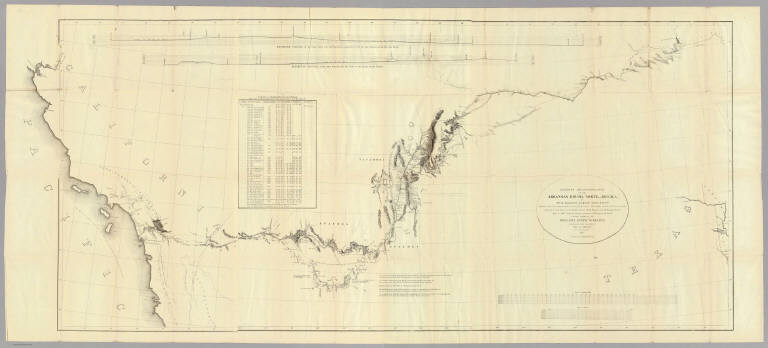
Author
Emory, William H.
Full Title
(Title Page to) Notes of a Military Reconnoissance, From Fort Leavenworth, In Missouri, To San Diego, In California, Including Part of the Arkansas, Del Norte, and Gila Rivers. By W.H. Emory, Brevet Major, Corps Topographical Engineers. Made in 1846-7, with the Advanced Guard of the "Army of the West." Washington: Wendell and van Benthuysen, Printers. 1848. [Senate] 30th Congress, 1st Session. Executive, No. 7.
List No
3639A
Author
Emory, William H.
Full Title
Military Reconnaissance Of The Arkansas Rio Del Norte And Rio Gila By W.H. Emory, Lieut. Top. Engrs. Assisted ... by J.W. Abert and W.G. Peck, and ... by W.H. Warner and Mr. Norman Bestor, Made in 1846-7, with the advance guard of the "Army of the West". Under Command Of Brig. Gen. Stephn. W. Kearny. Constructed under the orders of Col. J.J. Abert ... 1847. Drawn by Joseph Welch. Engraved on stone by E. Weber & Co. Baltimore.
List No
3639.001
Note
Senate edition. Has the large map, "Map of a Military Reconnaissance of the Arkansas Rio del Norte and Rio Gila..." See separate listing of the map. Book bound with linen covered boards with title on the spine.
Author
[Kenyon Company, Dahl, A.]
Full Title
(Covers to) Map Of Quay County New Mexico. Made By A. Dahl, Draftsman. Address: Aristo Studio - Opp. Post Ofice P.O. Box 7. Tucumcari. N. Mex. Copyright 1908, By A. Dahl. This Map for sale at the Picture Gallery ... The Kenyon Company, Map Makers, Des Moines, Iowa.
List No
3784.001
Note
Unusual relationship between a small local map maker (Mr. A. Dahl) and the large Kenyon Company. Full color by voting precinct. Folded into red card board covers 14x7.5 with "Map Of Quay County New Mexico. M.B. Goldenberg Co. General Merchandise At Retail and Wholesale Everything at Rock Bottom Prices. Tucumcari, N.M." printed in black.
Author
[Kenyon Company, Dahl, A.]
Full Title
Map Of Quay County New Mexico. Made By A. Dahl, Draftsman. Address: Aristo Studio - Opp. Post Ofice P.O. Box 7. Tucumcari. N. Mex. Copyright 1908, By A. Dahl. This Map for sale at the Picture Gallery ... The Kenyon Company, Map Makers, Des Moines, Iowa.
List No
3784.002
Note
Unusual relationship between a small local map maker (Mr. A. Dahl) and the large Kenyon Company. Full color by voting precinct. Folded into red card board covers 14x7.5 with "Map Of Quay County New Mexico. M.B. Goldenberg Co. General Merchandise At Retail and Wholesale Everything at Rock Bottom Prices. Tucumcari, N.M." printed in black.
Author
Colton, G.W.
Full Title
Colton's New Mexico and Arizona.
List No
3800.121
Author
Mitchell, Samuel Augustus
Full Title
A new map of the State of California, the Territories of Oregon & Utah, and the Chief part of New Mexico. Entered ... 1853, by Thomas, Cowperthwait & Co. ... Pennsylvania.
List No
3803.041
Note
Unlike 1852 ed., counties have been added for Oregon and Utah territories and additional counties added in New Mexico and the map has been extended to include more of New Mexico and Missouri Territory; part of Indian Territory shown. Full color. Relief shown by hachures and spot heights. Prime meridians are Greenwich and Washington.
Author
Mitchell, Samuel Augustus Jr.
Full Title
County map of Arizona and New Mexico. Entered ... 1874, by S. Augustus Mitchell ... Washington.
List No
3804.045
Note
Hand colored map by county. Shows settlements, Indian tribes and vilages, roads, railroads, etc. Relief shown by hachures. Prime meridians are Greenwich and Washington.
Author
[Johnston, Alexander Keith, 1804-1871, Rogers, Henry Darwin]
Full Title
Territory Of New Mexico. By Prof. H.D. Rogers & A. Keith Johnston, F.R.S.E. Entered in Sta. Hall. London ... & according to an act of Congress ... 1857, by H.D. Rogers ... Massachusetts. London, John Murray, Albemarle Street, Edinburgh, W. & A.K. Johnston. Engraved by W. & A.K. Johnston, Edinburgh.
List No
3825.019
Note
Territory shown in outline color and encompassing what would become Arizona. Proposed railway routes in purple.
Author
Gray, Ormando Willis
Full Title
New Mexico and Arizona.
List No
3888.051
Note
Prime meridians Washington D.C. and Greenwich. Relief shown by hachures. Full color.
Author
National Map Company
Full Title
Arizona and New Mexico. (Copyrighted by) National Map Company, Indianapolis. (to accompany) Official Paved Road and Commercial Survey of the United States.
List No
4048.056
Note
Outline color map. Shows administrative divisions, roads, rivers, etc. Relief shown by hachures. Prime meridian is Greenwich.
Author
Tanner, Henry S.
Full Title
(Covers to) Map of California New Mexico Texas &c. Published by H.S. Tanner No. 156 Fulton St. New York 1849.
List No
4073A
Author
Tanner, Henry S.
Full Title
Map of California New Mexico Texas &c. Published by H.S. Tanner No. 156 Fulton St. New York 1849.
List No
4073.001
Note
This is taken from Tanner's Map of the United States of Mexico, with the addition of the California Gold Regions colored in yellow, and an added inset map of "United States, Mexico &c. Shewing the Routes from N. York to St. Francisco by Land & Water." The map has been updated to show Fremont's route across the Great Basin and the "Boundary of 1848" with Mexico. The 14x9 cover entitled "Tanner's Travelling Map of California & c has on the inside front a "Table of Routes from New-York to California, with the Modes of Conveyance, Distances, Time and Fares." This is a very late map for Tanner, still printed from engraved plates (although the impression looks a bit tired), in the next to last year of his publishing career. He died in Brooklyn in 1858.
Author
(U.S. War Department) Office of the Chief of Engineers, U.S.A.
Full Title
Southwestern New Mexico. Published by the Office Of The Chief Of Engineers, U.S.A., 1883. Drawn by W. Kilp, Top. Asst. Office of the Chief Engineer; Department of the Missouri, 1883. Official Copy, O.M. Caiter ...
List No
4081.000
Note
A wonderfully detailed Army Engineers map of southwestern New Mexico, listed in Graff with no explanation for the fact that this map was clearly meant to be the lower left corner of a four sheet map of New Mexico. If all the other sheets were printed (and the fact that Graff only lists this sheet is indication that they may not have been) the resulting map would be huge - about 140 cm square. El Paso is shown, as is a small part of Arizona and Mexico. Given its large scale, one suspects that this was the most detailed map of New Mexico published at the time. Fitch 44-201 lists this map and the sheet that would join it above, titled Northwestern New Mexico, and dated 1885. Map is without color. Relief shown by hachures and spot heights.
Author
[Morse, Sidney E. (Sidney Edwards), 1794-1871, Breese, S.]
Full Title
A map of the Indian territory : Northern Texas and New Mexico; showing the great western prairies, by Josiah Gregg. Entered ... 1844, by Sidney E. Morse and Samuel Breese ... New-York. (to accompany) Supplement To The New-York Observer. The Cerographic Atlas Of The United States. No.3. 1845.
List No
4180.036
Note
Uncolored map. Shows settlements, towns, villages, forts and trading posts, roads, rivers, etc. Relief shown by hachures. Prime meridians are Greenwich and Washington. Includes note and explanation.
Author
State Farm Insurance Companies Travel Bureau
Full Title
State Farm Road map: Arizona, New Mexico. Copyright by Rand McNally & Company, Chicago, Ill. Lithographed in U.S.A. Z.3627. (on upper corners) Ariz. N. Mex.
List No
4246.013
Note
Color map. Shows roads, points of interest, distances, time zone boundaries, populations, etc. U.S. interstate and principal state highways shown in red. Relief shown by hachures.
Author
Thayer, H.L.
Full Title
(Covers to) Thayer's Map Of New Mexico. Published By H.L. Thayer, Denver, Col. From Surveys of the General Land Office, used by permission, revised & corrected to date by the Publisher. Photo lith & print by Julius Bien & Co. 16 & 18 Park Place N.Y.
List No
4335.001
Note
This is from the same plate used by Bien for the General Land Office "Map of The Territory of New Mexico" first issued in 1879. Comparing this with the 1882 GLO edition we can find absolutely no changes, notwithstanding Thayer's claims in the title. The only difference is the use of hand color by Thayer versus printed color by the GLO. Undated, with the date estimated by comparison with the GLO map of 1882. The Streeter copy is dated 1880. Scarce. Map is folded into dark green cloth covers 15x10 with "Thayer's Map Of New Mexico. One Dollar." stamped in gilt.
Author
Thayer, H.L.
Full Title
Thayer's Map Of New Mexico. Published By H.L. Thayer, Denver, Col. From Surveys of the General Land Office, used by permission, revised & corrected to date by the Publisher. Photo lith & print by Julius Bien & Co. 16 & 18 Park Place N.Y.
List No
4335.002
Note
This is from the same plate used by Bien for the General Land Office "Map of The Territory of New Mexico" first issued in 1879. Comparing this with the 1882 GLO edition we can find absolutely no changes, notwithstanding Thayer's claims in the title. The only difference is the use of hand color by Thayer versus printed color by the GLO. Undated, with the date estimated by comparison with the GLO map of 1882. The Streeter copy is dated 1880. Scarce. Map is folded into dark green cloth covers 15x10 with "Thayer's Map Of New Mexico. One Dollar." stamped in gilt.
Author
Clason Map Company
Full Title
Clason's Road Map of Arizona and New Mexico. Showing paved roads, All weather roads and other throughfares. (U.S. Highways shown in red.) Published by the Clason Map Co., Chicago-Denver. Copyrighted Clason Map. All rights reserved. Map No. R-208A.
List No
4423.044
Note
Color map. Includes road legend, and Index of cities and towns giving populations and Key to map.
Author
Rand McNally and Company
Full Title
Rand, McNally & Co.'s New Mexico.
List No
4520.049
Note
Counties in outline color. Relief shown by hachures and spot heights. Prime meridians: Greenwich and Washington.
Author
Cram, George Franklin
Full Title
Cram's Rail Road & Township Map of New Mexico.
List No
4533.032
Author
Mitchell, Samuel Augustus
Full Title
A New Map of Nebraska, Kansas, New Mexico, and Indian Territories. Published By Charles Desilver, Philadelphia. Entered according to Act of Congress in the year 1856 by Charles Desilver in the Clerk's office if the District Court of the Eastern District of Pennsylvania. 38.
List No
4557.037
Note
Counties tinted in color. Meridian Washington and Greenwich. Relief shown by hachures. Shows tribes fo Native Americans.
Author
Cram, George Franklin
Full Title
New Rail Road and County Map of New Mexico.
List No
4558.055
Author
Mitchell, Samuel Augustus Jr.
Full Title
County map of Arizona and New Mexico. Entered ... 1877 by S. Augustus Mitchell, . ... Washington.
List No
4564.046
Note
Full color map by county. Shows railroad, river, fort, Indian settlements, exploration routes and explorers, etc. Relief shown by hachures and spot heights.
Author
Colton, G.W.
Full Title
Colton's New Mexico and Arizona. Published By G. W & C. B. Colton & Co., No. 172 William St. New York.
List No
4587.066
Note
Prime meridians are Washington D.C. and Greenwich.
Author
U.S. General Land Office
Full Title
Department Of The Interior General Land Office J.A. Williamson, Commissioner. Territory Of New Mexico. 1879. Compiled from the official Records of the General Land Office and other sources by C. Roeser, Principal Draughtsman G.L.O. Photo lith & print by Julius Bien 16 & 18 Park Place N.Y.
List No
4621.000
Note
Shows land grants. Printed color.
Author
Cram, George Franklin
Full Title
Railroad and County Map of New Mexico. Geo. F. Cram. Engraver and Publisher, Chicago.
List No
4727.048
Note
Prime meridians Washington D.C. and Greenwich. Relief shown by hachures. With printed color.
Author
Gray, Ormando Willis
Full Title
Gray's Atlas Map of New Mexico and Arizona.
List No
4740.055
Note
Prime meridians Washington D.C. and Greenwich. Relief shown by hachures.
Author
Johnson, Alvin Jewett, 1827-1884.
Full Title
Johnson's California, also Utah, Nevada, Colorado, New Mexico and Arizona. Published by Alvin J. Johnson & Son, New York. Entered ... 1864, by A.J. Johnson ... New York. (to accompany) Johnson's New Illustrated Family Atlas Of The World ... MDCCCLXXX (1880).
List No
4830.097
Note
Engraved hand colored in outline map. Shows state and county boundaries, towns, villages, forts, Indian habitation, explorers routes, mining districts, roads, railroads, canals, lakes, mountains and rivers. Relief shown by hachures. Prime meridians are Greenwich and Washington.
Author
Mitchell, Samuel Augustus
Full Title
Map of the State of California, the Territories of Oregon & Utah, and the Chief Part of New Mexico.
List No
4835.047
Note
Unlike 1849 ed., this shows California gold region named and shown in yellow. It also adds basin and range topography in Nevada including Carson and Walker lakes, and the Humboldt River (although in a manner different from the late 1850 and subsequent additions -- they probably drew the topographical changes in quickly, and then corrected them in later editions). Roads colored in red ink. Relief shown by hachures and spot heights. "Oregon" and "Upper or New California" in bold type; all areas shown in full color. Shows Indian tribes and includes descriptive notes. Prime meridians: Greenwich and Washington.
Author
[Morse, Sidney E. (Sidney Edwards), 1794-1871, Breese, S.]
Full Title
A map of the Indian Territory, northern Texas and New Mexico : Showing the great western prairies by Josiah Gregg. Entered ... 1844 by Sidney E. Morse and Samuel Breese ... New York. (New York: Published by Harper & Brothers, 1845). (to accompany) Morse's Cerographic Maps. 1845. No. I.
List No
4861.007
Note
Wax engraved map. Shows towns, Indian villages, forts and fortifications, rivers, ranchos, springs, sandy regions, etc. Covers part of Kansas, Colorado, Oklahoma, and Missouri. Relief shown by hachures. prime meridians are Washington and Greenwich.
Author
Rand McNally and Company
Full Title
(Covers to) Rand McNally & Co.'s New Mexico.
List No
4885.001
Note
This is the cheap series, issued without the index. To the right of neat line reads "This Map, with Index, by which Counties, Cities, Railroads, Lakes, Rivers, etc., can be located as readily as a word can be found in a dictionary; with population, names of Express Companies, etc; neatly bound. Price 50 cents." Printed outline color by county. Folded into pink card board covers 15.5x9 with "Rand, McNally & Co's. County And Railroad Map Of New Mexico. 25 Cent Series. Rand, McNally & Co. Map Publishers And Engravers, Chicago." printed in black. Prime meridians are Greenwich and Washington D.C. Relief shown by hachures.
Author
Rand McNally and Company
Full Title
Rand McNally & Co.'s New Mexico.
List No
4885.002
Note
This is the cheap series, issued without the index. To the right of neat line reads "This Map, with Index, by which Counties, Cities, Railroads, Lakes, Rivers, etc., can be located as readily as a word can be found in a dictionary; with population, names of Express Companies, etc; neatly bound. Price 50 cents." Printed outline color by county. Folded into pink card board covers 15.5x9 with "Rand, McNally & Co's. County And Railroad Map Of New Mexico. 25 Cent Series. Rand, McNally & Co. Map Publishers And Engravers, Chicago." printed in black. Prime meridians are Greenwich and Washington D.C. Relief shown by hachures.
|