|
Author
[Sartine, Antoine, Depot de la Marine]
Full Title
Carte de la Baye et Rivière de Delaware
List No
15933.020
Author
[Sartine, Antoine, Depot de la Marine]
Full Title
Carte de l'Entrée de la Rivière d’Hudson
List No
15933.021
Author
[Guyer, Terry, BioSpace]
Full Title
Pharm Country 2000
List No
15307.000
Author
[Guyer, Terry, Synergistic Designs Inc, Fusionscape]
Full Title
Pharma Country Fusionscape TM, copyright Synergistic Designs Inc. 1996
List No
15756.000
Author
[Fisher, Joseph R., Planters Peanuts (Firm)]
Full Title
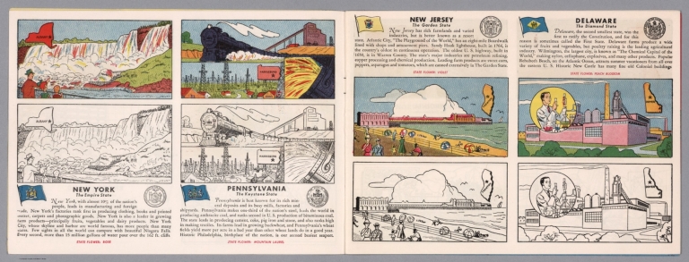
New York : The empire state -- Pennsylvania : The keystone state -- New Jersey : The garden state -- Delaware : The diamond state.
List No
14374.005
Note
Four views, representing New York, Pennsylvania, New Jersey and Delaware. Views show examples of the landscape and natural resources. Each view includes an inset map of the state, which marks the location of the capital city with a star. Accompanied by descriptive text, the state flags, seals and flowers: rose, mountain laurel, violet and peach blossom, respectively. The view of each state appears both in color (on top) and in black and white (bottom), the latter inviting coloration. Together, views are 18 x 52 cm, on two sheets 20 x 54 cm.
Author
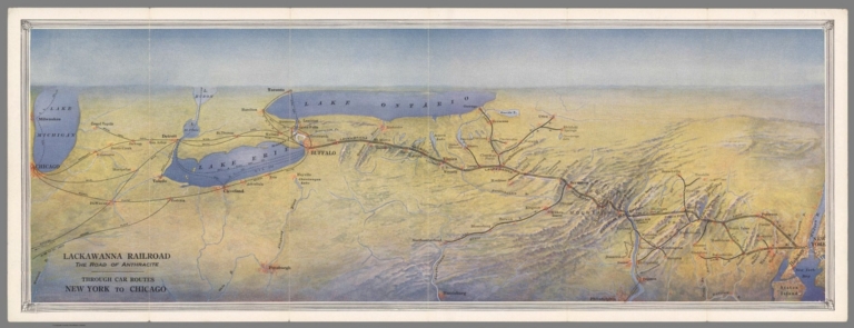
Lackawanna Railroad
Full Title
Lackawanna Railroad. The Road of Anthracite. Through Car Routes New York to Chicago.
List No
10610.003
Author
Sotzmann, Daniel Friedrich
Full Title
New Jersey : Entworfen von D.F. Sotzmann. Hamburg bey Carl Ernest Bohm 1797.
List No
13124.000
Note
Color map of the State of New Jersey. Shows administrative divisions, major cities, roads and rivers. Relief shown by hachures. Place names in English and German. Relief shown by hachures. Prime meridians: Greenwich and Washington. In upper right margin: No. VIII. In lower right margin: "Zu Ebelings Erdbeschreibung von Amerika."
Author
[Lea, Philip, Thornton, John, Morden, Robert]
Full Title
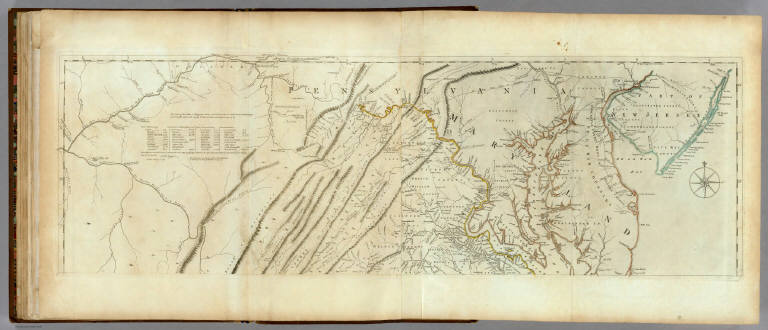
A New Map of New England New York New Iarsey Pensilvania Maryland and Virginia
List No
10119.000
Note
"Early and highly important map of the English Colonies in North America, which includes the earliest printed plan of New York Harbor. Thornton, Morden & Lea's map is the first obtainable state of the finest general map of England’s American colonies to date. The map is one of the earliest to include Augustine Herrman’s cartography for Virginia and Maryland. To the North it includes one of the earliest depictions of the Pennsylvania colony (est. 1681), the first printed chart of New York Harbor, and significant additions to the cartography of New England. The map shows the English colonies from Cape Ann in Massachusetts to Cape Henry at the mouth of Chesapeake Bay. The map extends as far north as the tributaries of the Hudson, and in the southwest it shows the Delaware and Susquehannah Rivers and as far west as the tributaries of the Potomac and Rapahannock. Augustyn and Cohen note the importance of the inset:: 'To the ambitious person, the map would have presented an enticing vista: it displays a loose federation of colonies, between and beyond which there appears to be ample unclaimed land. It creates an image of an area comfortingly linked by civilization but still containing much open territory.'The geography of Virginia, Maryland, Pennsylvania and New Jersey derives from the Thornton-Greene Mapp of Virginia Mary-land, New Jarsey, New-York, & New England (ca 1678), whose depiction of the region is in turn based largely on Augustine Herrman’s Virginia and Maryland (1673). The Thornton-Morden-Lea departs from these prototypes, however, in showing the new colony of Pennsylvania and incorporating changes to the course of the Delaware and place names along its banks. New York and southern New England are drawn from the Thornton-Greene map, which in turn draws on John Seller’s Mapp of New England (1676). Here as well, Thornton, Morden and Lea, have departed substantially from the prototypes: Long Island’s barrier beaches are shown for the first time on a printed map and numerous place names are introduced along the Connecticut coast and on Cape Cod; the boundaries between Massachusetts, Plymouth and Connecticut colonies are drawn; and several roads are shown. " (Ruderman)
Author
Baker, Harriet E.
Full Title
New Jersey. (to accompany) Harriet E. Baker's Book of Penmanship & Map. At Mr. Dunham's School Windsor Vermont March 31, 1819.
List No
8307.032
Note
Outline color map by county, with decorative cartouche. Showing cities and towns, and rivers. Relief shown by hachures.
Author
[Hammond, John T., Squire, B.S.]
Full Title
Squire's Map Of The State Of New Jersey. Drawn & Engraved by John T. Hammond, New-York, 1836. Entered ... 27th of July 1835 by B.S. Squire Jr. ... New York. (with 8 inset maps).
List No
0944.000
Note
Drawn and engraved by John T. Hammond. Entered by Squire in 1835. Not in Phillips, or Ristow. Engraved view of the Passaic(?) Falls. Eight inset maps of New Jersey cities. Hammond also did a Traveller's Map of Michigan, 1839. Originally a wall map but now without rollers. Full color by county.
Author
[Mitchell, John, Raynal, G.T., Zatta, Antonio]
Full Title
Il Maryland, il Jersey Meridionale, la Delaware, e la Parte Orientale della Virginia, e Carolina Settentrionale. Fogl. VIII.
List No
5007.010
Note
In outline color.
Author
Appleton, D. & Co.
Full Title
Map of New Jersey. Copyright 1891 by Matthews-Northrup Co. ... Buffalo, New York. (inset: Hundson County). (to accompany) The Library Atlas Of Modern Geography ... New York, D. Appleton And Company 1892. (on upper margin) New Jersey. 84.
List No
0026.218
Note
Color map. Shows state and county boundaries and county seat, capital, railways, roads, rivers, etc. "Size of type indicates importance of the places". Includes notes. Prime meridians are Greenwich and Washington.
Author
Arbuckle Bros.
Full Title
Massachusetts, Vermont, Kentucky, New Jersey. Copyright 1889 Arbuckle Bros. N.Y.
List No
0027.002
Note
Sheet with maps of four states in full color. The card for Massachusetts notes that it is the leading state in its manufacture of paper and leather. Vermont is noted for being "extremely healthy" with "miasmatic diseases...totally unknown." Each card measures 7.5 x 12.5 cm.
Author
Lewis, Samuel
Full Title
New Jersey. Drawn by S. Lewis. Tanner sc. (Boston: Published by Thomas & Andrews. 1812)
List No
0028.038
Note
Engraved map, uncolored. Relief shown by hachures. Prime meridian: Philadelphia.
Author
Asher & Adams
Full Title
Asher & Adams' Pennsylvania and New Jersey. Entered according to Act of Congress in the year 1874 by Asher & Adams ... at Washington. (New York, 1874)
List No
0041.007
Note
Hand col. engraved map. Relief shown by hachures. Shows distances along railroads, etc. Prime meridians: Greenwich and Washington.
Author
Beers, Frederick W.
Full Title
Map of New York and Vicinity Accompanying Atlas of New York and Vicinity, Published by Beers, Ellis & Soule, 95 Maiden Lane, New York.
List No
0064.005
Note
Fold-out map.
Full Title
City and county of New York. Copyrighted by Julius Bien & Co. 1890. (1893)
List No
0070.002
Note
Col. lithograph map. Shows streets, railroads, ferries, marshland, etc.
Full Title
Westchester County, Yonkers to Dobbs Ferry, east to state line. Copyrighted by Julius Bien & Co., 1890. (1893)
List No
0070.035
Note
Col. lithograph. Relief shown by contours, shading and spot heights; depths by soundings and isolines. Topographic map showing streets, neighborhoods, railroads, ferries, woods, marshes, etc. Unlike issue in 1891 Atlas of the Metropolitan District ..., this lacks plate number and has in lower left margin: From Atlas of the Metropolitan District published by Julius Bien & Company.
Author
[Bartholomew, John, Black, Adam & Charles]
Full Title
Pennsylvania and New Jersey. Published by A. & C. Black. Edinburgh. Printed in Colours by Schenck & Macfariane. Edinburgh. Drawn & Engraved by J. Bartholomew, Edinburgh.
List No
0073.007
Note
States outlined in color. Land tinted.
Author
Bradford, Thomas G.
Full Title
New Jersey. Entered ... 1838, by Thos. Gordan ... New Jersey. Reduced from T. Gordan's Map of N. Jersey, with part of the adjoining States. Engraved by G.W. Boynton.
List No
0089.015
Note
Map in full color by county.
Full Title
Carte geographique, statistique et historique du New-Jersey. New Jersey. Fonderie et Imprimerie de J. Carez. (1825)
List No
0102.017
Note
Hand colored engraved map. Relief shown by hachures. Text and tables at sides and bottom. Prime meridians: Washington and Paris.
Author
Burr, David H., 1803-1875
Full Title
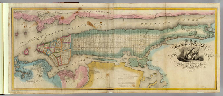
Map of the City and County of New York with the adjacent country, by David H. Burr, published by Simeon DeWitt, Surveyor General, pursuant to an Act of the Legislature. Second edition 1832.
List No
0103.002
Note
Hand col. engraved map on 2 sheets. Relief shown by hachures. Covers also Jersey City and Horsimus and other communities in N.J. Ornamental cartouche. Includes "Remarks" on streets and distances. David Rumsey Collection copy mounted as 1 sheet.
Author
Burr, David H., 1803-1875
Full Title
Map of New Jersey And Pennsylvania Exhibiting the Post Offices, Post Roads, Canals, Rail Roads, &c. By David H. Burr. (Late Topographer to the Post Office.) Geographer to the House of Representatives of the U.S. John Arrowsmith. Entered ... July 10th, 1839, by David H. Burr ... District of Columbia.
List No
0104.004
Note
In full color by county. Postal routes by coach, stage, sulkey, cross, rail roads and canals shown. In 8 sections mounted on linen. Label on back states "No. 4. New Jersey, Pennsylvania."
Author
[Carey, H. C., Lea, I.]
Full Title
Geographical, Historical, And Statistical Map Of New Jersey. New Jersey. No. 17. Kneass sc.
List No
0122.012
Note
In full color by county surrounded by text.
Author
Colton, G.W.
Full Title
New Jersey. Published by J.H. Colton & Co. 172 William St. New York. Entered ... 1855 by J.H. Colton & Co. ... New York. No. 19.
List No
0149.025
Note
In full color by county.
Author
Colton, G.W.
Full Title
Colton's New Jersey. Published By J. H. Colton. No. 172 William St. New York.
List No
0151.032
Note
Map showing the county boundaries in color. Prime meridians are Greenwich and Washington D. C.
Author
Colton, G.W.
Full Title
Colton's New York City, Brooklyn, Jersey City, Hoboken, Etc. Published by G. W & C. B. Colton & Co., No. 172 William St. New York.
List No
0152.030
Note
(inset) The upper part of New York City with the adjacent portion of Westchester County.
Author
Colton, G.W.
Full Title
Colton's New Jersey. Published by G. W & C. B. Colton & Co., No. 172 William St. New York.
List No
0152.031
Note
Prime meridians are Washington D.C. and Greenwich.
Author
Cram, George Franklin
Full Title
Railroad and County Map of New Jersey.
List No
0210.028
Note
Prime meridians Greenwich and Washington.
Author
Finley, Anthony
Full Title
Map Of Pennsylvania New Jersey And Delaware Constructed from the Latest Authorities 1825. D.H. Vance del. J.H. Young Sc. Published by A. Finley Philada.
List No
0278.006
Note
In full color by county with broad lines of color between states. Statistical table details population by county in 1810 and 1820. Square mileage by state also included.
Author
Finley, Anthony
Full Title
Map of Pennsylvania, New Jersey, and Delaware, Constructed from the Latest Authorities.
List No
0279.010
Note
Date estimated.
Author
Finley, Anthony
Full Title
Map of Pennsylvania, New Jersey, and Delaware, Constructed from the Latest Authorities. Drawn by D.H. Vance. Published by A. Finley, Philada. Engraved by J.H. Young.
List No
0280.006
Note
Relief shown by hachures. Prime meridian Washington. Statistical table for state.
Author
Finley, Anthony
Full Title
New Jersey. Young & Delleker Sc. Published by A. Finley, Philada. (to accompany) A New General Atlas Comprising a Complete Set of Maps, representing the Grand Divisions Of The Globe ... Philadelphia: Published by Anthony Finley. 1827.
List No
0282.018
Note
Full color map on sheet 35x27. Relief shown pictorially. Prime meridians are Washington and Greenwich. Shows counties, major cities, roads and rivers.
Author
Finley, Anthony
Full Title
New Jersey. Published by A. Finley Philada. Young & Delleker Sc.
List No
0285.014
Note
Full color by county.
Author
Gray, O.W.
Full Title
Gray's Atlas Map of New Jersey.
List No
0310.043
Author
[Colton, G.W., Colton, C.B., Gray, O.W.]
Full Title
New Jersey. Entered ... 1868 by G.W. & C.B. Colton & Co. ....
List No
0312.016
Author
[Jefferys, Thomas, Holland, Samuel, 1728-1801]
Full Title
The Provinces of New York, and New Jersey; with part of Pensilvania, and the Province of Quebec. Drawn by Major Holland, Engraved by Thomas Jefferys, Geographer to His Majesty. Corrected and Improved, from the Original Materials, By Governr. Pownall, Member of Parliament 1776. (with) three inset maps: A Chart Of The Mouth Of Hudson's River, from Sandy Hook to New York; A Plan Of The City Of New York; and Plan Of Amboy, With its Environs, from an Actual Survey. London. Printed for Robt Sayer & John Bennett ... 17 Augt. 1776.
List No
0346.020
Note
In outline color with the future Vermont in yellow. Land grants are shown directly south of the "Coughsaghrage or the Beaver Hunting Country Of The Confederate Indians." Hudson River inset shows soundings and New York City's plan includes numbered buildings and a list of references.
Author
[Jefferys, Thomas, Fry, Joshua, 1700 (ca.)-1754, Jefferson, Peter, 1708-1754]
Full Title
A Map of the most Inhabited part of Virginia containing the whole province of Maryland with Part of Pensilvania, New Jersey and North Carolina. Drawn by Joshua Fry & Peter Jefferson in 1775. Printed for Robt. Sayer ... London. (Northern Section)
List No
0346.023
Note
Map in two sections this being the northern one. Distances and directions shown on chart derived by J. Dalrymple in 1755. Map in outline color by state. Title cartouche on lower half.
Author
[Jefferys, Thomas, Fry, Joshua, 1700 (ca.)-1754, Jefferson, Peter, 1708-1754]
Full Title
(Composite of) A Map of the most Inhabited part of Virginia containing the whole province of Maryland with Part of Pensilvania, New Jersey and North Carolina. Drawn by Joshua Fry & Peter Jefferson in 1775. Printed for Robt. Sayer ... London.
List No
0346.025
Note
Distances and directions shown on chart derived by J. Dalrymple in 1755. Note below cartouche states: "To the Right Honourable, George Dunk Earl of Halifax First Lord Commissioner; and to the Rest of the Right Honourable and Honourable Commissioners, for Trade and Plantations. This Map is most humbly Inscribed to their Lordships, By their Lordship's Most Obedient & most devoted humble Servt. Thos. Jefferys." Survey lines are noted and explained. In outline color by state.
Author
Johnson, A.J.
Full Title
Johnson's Pennsylvania And New Jersey Published By Johnson and Ward. Entered ... 1864 , by A.J. Johnson ... New York.
List No
0352.023
Note
In full color by county. Relief shown by hachures. Prime meridians are Greenwich and Washington D.C.
Author
Johnson, A.J.
Full Title
Johnson's Pennsylvania and New Jersey. Entered ... 1864.
List No
0358.028
Author
Johnson, A.J.
Full Title
Johnson's New Jersey. Entered ... 1868.
List No
0358.029
Author
Leahy, J.F.
Full Title
(Index to) Leahy's Hotel Guide and Railway Distance Maps. New Jersey. New Mexico.
List No
0425.080
Note
Alphabetical index list of the Hotels of the town with the number of rooms of each, their rates per day and the population of the town. Includes population of the state, and Explanation of abbreviation of the railroad of the state.
Author
Leahy, J.F.
Full Title
Leahy's Hotel Guide and Railway Distance Map of the State of New Jersey. Published by American Hotel Register Company. Leahy Build., 228-234 W. Ontario St., Chicago, Ill. Copyrighted by J.F. Leahy, Jan., 1934.
List No
0425.081
Note
Map printed without color. Includes name of the railroad entering the town, and distance between towns.
Author
Leahy, J.F.
Full Title
(Index to) Leahy's Hotel Guide and Railway Distance Maps. New Jersey (Continued). New Mexico.
List No
0425.082
Note
Continuation index list of the Hotels of the town with the number of rooms of each, their rates per day and the population of the town in New Jersey and Index list of New Mexico. Includes population of the states, Explanation of abbreviation of the railroad of the state, and advertisement.
Author
Marshall, John
Full Title
Theatre des Operations des Armees Americaine et Britannique en 1776 et 1777, depuis la Riviere de Rariton, dans a la tete de L'Elk dans le Maryland. (1807)
List No
0462.008
Note
Engraved. Folded map. Relief shown by hachures.
Author
Marshall, John
Full Title
Partie Septentrionale du New Jersey, et Positions des Armees Americaine et Britannique Apres le Passage de la Riviere de Nord, en 1776. (1807)
List No
0462.009
Note
Engraved. Folded map. Relief shown by hachures.
Author
[Lawrence, Martin, Washington, George]
Full Title
A map of part of the States of New-York and New-Jersey: laid down, chiefly from actual surveys, received from the Right Honble. Ld. Stirling & others, and deliniated for the use of His Excely. Genl. Washington by Robt. Erskine, F.R.S., 1777. Robert Erskine's map of New Jersey in 1777, delineated for the use of George Washington and annotated by him in sixteen places.
List No
0465.018
Note
Uncolored map. Include notes by George Washington.
Author
[Lawrence, Martin, Washington, George]
Full Title
New Jersey, showing in red the places visited by George Washington.
List No
0465.032
Note
Color map. Showing Washington's headquarters, Capital, and towns. Date estimated.
Author
Melish, John
Full Title
Map of the American Coast, from Lynhaven Bay to Narraganset Bay, by John Melish.
List No
0495.002
Note
Fold-out map in outline color stretching from Long Island Sound to Norfolk, Virginia.
Author
Johnson, A.J.
Full Title
Johnson's Pennsylvania And New Jersey Published By Johnson and Ward.
List No
0535.022
Note
In full color by county. Relief shown by hachures. Meridians Greenwich and Washington D.C.
Author
Mitchell, Samuel Augustus
Full Title
New Jersey Reduced From T. Gordon's Map By H.S. Tanner. Published By S. Augustus Mitchell, N.E. corner of Market & 7th Street Philada., 1846. Entered ... 1834 by T. Gordon ... New Jersey.
List No
0537.013
Note
Full color map by county with population figures over time.
Author
Mitchell, Samuel Augustus
Full Title
New Jersey, Reduced from T. Gordon's Map by H.S. Tanner. Published By S. Augustus Mitchell. N.E. corner of Market & 7th. Streets. Philada. 1848. Entered ... 1834 by T. Gordon ... New Jersey.
List No
0545.016
Note
Full color map, tinted by county. Explanation chart, showing symbols to roads, railroads, canals, land distances, and county towns. Prime meridian is Washington. Relief shown by hachures. Includes statistical tables.
Author
Mitchell, Samuel Augustus
Full Title
County Map Of Pennsylvania, New Jersey, Maryland, And Delaware. 18. (with) two insets of Philadelphia. 19. and City Of Baltimore. 20. Entered ... 1860, by S. Augustus Mitchell, Jr. ... Pennsylvania.
List No
0565.012
Note
Full color by county and outline by state. Street plans of Philadelphia and Baltimore shown.
Author
Mitchell, Samuel Augustus Jr.
Full Title
County map of New Jersey. (Scale: 1:1,100,000). County map of Maryland and Delaware. Drawn & Engraved by W.H. Gamble Philadelphia. (Scale: 1,550,000). Entered ... 1865 by S. Augustus Mitchell, Jr. ... Pennsylvania.
List No
0572.021
Note
Two color county maps on one page. Relief shown by hachures. Prime meridians are Greenwich and Washington, D.C.
Author
Mitchell, Samuel Augustus Jr.
Full Title
County map of New Jersey. (inset) 27. County map of Maryland and Delaware. Drawn and Engraved by W.H. Gamble Philadelphia. Entered ... 1867 by S. Augustus Mitchell, Jr. ... Pennsylvania.
List No
0579.021
Note
Color map by county. Relief shown by hachures. Prime meridians are Greenwich and Washington, D.C.
Author
Mitchell, Samuel Augustus
Full Title
Plan of the city of Philadelphia and Camden. Drawn and engraved by W.H. Gamble, Philadelphia. Entered ... 1879 by S. Augustus Mitchell ... Washington. (1880)
List No
0586.018
Note
Hand colored. Shows wards, major buildings, railroads, ferries, etc.
Author
Mitchell, Samuel Augustus
Full Title
County map of New Jersey. County map of Maryland and Delaware. Drawn and engraved by W.H. Gamble, Philadelphia. Entered ... 1879 by S. Augustus Mitchell ... Washington. (1880)
List No
0586.019
Note
Two hand colored maps. Relief shown by hachures. Show settlements, railroads, etc. Prime meridians: Greenwich and Washington.
Author
Mitchell, Samuel Augustus Jr.
Full Title
County map of the state of New Jersey. Copyright 1882, by Bradley & Company.
List No
0592.018
Note
Hand colored. Relief shown by hachures. Shows settlements, railroads, rivers, etc. Prime meridians: Greenwich and Washington.
Author
Mitchell, Samuel Augustus Jr.
Full Title
Plan of the city of Philadelphia and Camden. Drawn and engraved by W.H. Gamble. Copyright by S. Augustus Mitchell 1884.
List No
0592.021
Note
Hand colored. Relief shown by hachures. Shows wards, major buildings, railroads, ferries, etc.
Full Title
County map of the state of New Jersey. Copyright 1887 by Wm. M. Bradley & Bro. (1890)
List No
0594.017
Note
Hand colored. Relief shown by hachures. Shows settlements, railroads, rivers, etc. Prime meridians: Greenwich and Washington.
Full Title
Plan of the city of Philadelphia and Camden. Drawn and engraved by W.H. Gamble. Copyright 1887 by Wm. M. Bradley & Bro. (1890)
List No
0594.020
Note
Hand colored. Relief shown by hachures. Shows wards, major buildings, railroads, ferries, etc.
Author
[Morse, Charles W., Colby, Charles A.]
Full Title
New Jersey.
List No
0623.019
Author
Morse, Jedidiah
Full Title
A Map of New Jersey from the best Authorities. Published Sepr. 8th 1794 by J. Stockdale, Piccadilly.
List No
0632.012
Note
Without color.
Author
[Paullin, Charles O., Wright, John K.]
Full Title
Plate 160. Military History. The American Revolution, 1775 - 1783. 1775 - 1776. 1777. 1778 - 1779. Naval Battles, 1776 - 1800, War of the Revolution and War with France. The South, 1778 - 1779. The South, 1780. New York and New Jersey, 1780, Greene's Campaigns, 1781. 1781, Yorktown, 1781.
List No
0702.163
Author
[Reid, John, Winterbotham, W.]
Full Title
The State of New Jersey, Compiled from the most Accurate Surveys. Martin sculpt. Publish'd by John Reid.
List No
0845.011
Note
Uncolored.
Author
Scott, Joseph
Full Title
New Jersey.
List No
0887.005
Note
Uncolored.
Author
[Scovel, James L., O'Brien, Emmett J]
Full Title
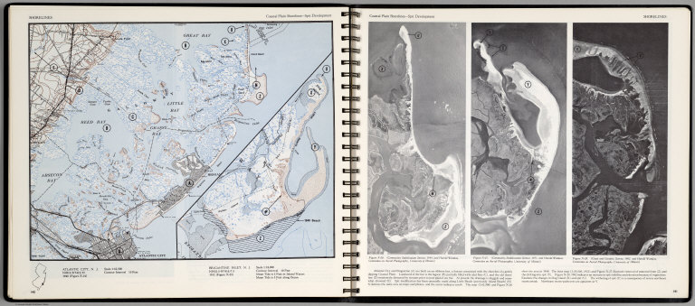
Shorelines. Coastal Plain Shorlines-Split Development. Atlantic City, N.J. (inset map) Brigantine Inlet, N.J. (with three aerial views on opposite page).
List No
0889.074
Note
Contour color maps, with location map and text. Aerial views of Atlantic city and Brigantine. Relief shown by contours and spot heights.
Author
Tanner, Henry S.
Full Title
New Jersey, Reduced from T. Gordon's Map by H.S. Tanner.
List No
0976.016
Author
Tanner, Henry S.
Full Title
New Jersey Reduced From T. Gordon's Map By H.S. Tanner. J. Knight Sc. Entered ... 1833 by H.S. Tanner ... Pennsylvania. Published by H.S. Tanner, Philadelphia. (above neat line) Tanner's Universal Atlas.
List No
0977.011
Note
State in full color by county with population statistics by county, town, and date. Route mileage charted from Trenton to numerous cities by stage and steamboat.
Author
Tanner, Henry S.
Full Title
Florida Canal ; Morris Canal N. J. ; Union Canal Pa. ; Schuylkill Navigation Penn. ; Profile of the Pennsylvania Canal. (with inset profile) Columbia railroad Pa. (to accompany) A Description of the Canals and Railroads of the United States.
List No
0979.006
Note
Six profiles on one page.
Author
Tanner, Henry S.
Full Title
New Jersey, Reduced from T. Gordon's Map by H.S. Tanner.
List No
0980.016
Author
Thomas, Cowperthwait & Co.
Full Title
(Covers to) New Jersey. Sold By Thomas, Cowperthwait & Co. No. 253 Market Street, Philada. 1845. Engraved by J.H. Young.
List No
0998.001
Note
Engraved by J.H. Young, this was first issued by Anthony Finley in 1834 - see our #5146. Full color map, folded into stamped red leather covers 12.5x8 with "New-Jersey" stamped in gilt. Prime meridians are Greenwich and Washington D.C.
Author
Thomas, Cowperthwait & Co.
Full Title
New Jersey. Sold By Thomas, Cowperthwait & Co. No. 253 Market Street, Philada. 1845. Engraved by J.H. Young.
List No
0998.002
Note
Engraved by J.H. Young, this was first issued by Anthony Finley in 1834 - see our #5146. Full color map, folded into stamped red leather covers 12.5x8 with "New-Jersey" stamped in gilt. Prime meridians are Greenwich and Washington D.C.
Author
Senex, John (c.1678-1740)
Full Title
A New Map of Virginia and the Improved Parts of Pennsylvania & New Jersey.
List No
10014.258
Author
L. Bamberger & Co.
Full Title
(Covers to) New Jersey
List No
10114.001
Note
Date estimated.
Author
L. Bamberger & Co.
Full Title
New Jersey
List No
10114.002
Note
Date estimated.
Author
United States. Post Office Department
Full Title
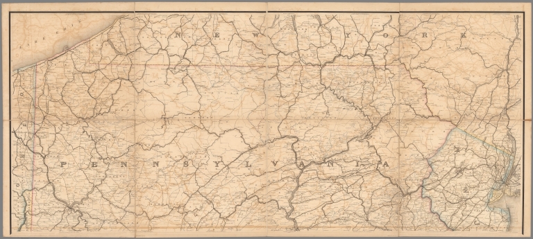
Upper Part Post Route Map of the States of Pennsylvania, New Jersey, Delaware, Maryland and of the District of Columbia.
List No
10436.002
Note
Updated to 1879 from 1869. 8 panels.
Author
United States. Post Office Department
Full Title
Lower Part Post Route Map of the States of Pennsylvania, New Jersey, Delaware, Maryland and of the District of Columbia.
List No
10436.004
Note
Updated to 1879 from 1869. 8 panels.
Author
United States. Post Office Department
Full Title
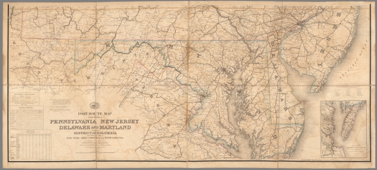
(Composite Map) Post Route Map of the States of Pennsylvania, New Jersey, Delaware, Maryland and of the District of Columbia.
List No
10436.005
Note
Updated to 1879 from 1869. 8 panels.
Author
U.S. General Land Office
Full Title
(Map 3 - Virginia, West Virginia, Ohio, Pennsylvania, Maryland, Delaware, New Jersey, New York, Rhode Island, Massachusetts, Connecticut).
List No
1071.005
Note
One of the series of adjacent sixteen maps. Mounted on linen. Relief shown in hachures.
Author
Des Rosiers, Leon L.
Full Title
Historical map of the state of New Jersey. Published by the Historical Map Bureau, W. Willington, Conn. Designed by Leon L. Des Rosiers.
List No
11378.000
Note
Color pictorial map of the state of New Jersey, borders with important historical events, places and famous people. Includes pictorial illustrations of various places, agricultural products, landmarks, industry, noted historical events, cities, towns, roads, airports, canals and railroads. Relief shown pictorially. Date estimated.
Full Title
Map of the compact portions of Philadelphia and Camden. (Published by Stedman, Brown & Lyon, Philadelphia), 1872.
List No
1155.026
Note
Hand col. lithographed map. Shows wards, major buildings, railroads, ferry routes, parks, cemeteries, etc.
Author
Meyer, Joseph, 1796-1856
Full Title
Die Staaten von New York, Pennsylvania, Maryland, New Jersey, Delaware & Virginia. 1850. Stahlstich (Direction v. Kleinknecht) aus der Schweinfurter Geographischen Graviranstalt des Bibliographischen Instituts zu Hildburghausen, Amsterdam, Paris u. Philadelphia. (in upper margin) Meyer's Zeitung Atlas. No. 70. (to accompany) Neuester Zeitungs-Atlas fur Alte und Neue Erdkunde. Herausgegeben von J. Meyer.
List No
11652.094
Note
Engraved outline hand color map of the Mid-Atlantic States. With 6 insets: New York and vicinity, Philadelphia and vicinity, Niagara Falls and vicinity, Albany and vicinity, Pittsburg and vicinity and Baltimore and Washington DC and vicinity. Shows administrative boundaries, cities and towns. Relief shown by hachures. Prime meridians are Greenwich and Washington.
Author
Seutter, Matthaeus, 1678-1756
Full Title
45. Pensylvania, Nova Jersey et Nova York.
List No
12040.111
Note
Date estimated.
Author
Goos, Pieter, 1616-1675
Full Title
Paskaerte van de Zuydt en Noordt Rever in Nieu Nederlant.
List No
12179.041
Author
[Weiland, Carl Ferdinand, 1782 -1847, Hassel, Georg, 1770-1829]
Full Title
Geographisch-statistische und historische Charte von Neu-Jersey.
List No
12293.011
Author
[Price, T. T., Rose, Theodore F., Woolman, H. C.]
Full Title
(Covers to) Historical and biographical atlas of the New Jersey coast. Proposed, arranged and illustrated by T.F. Rose. Surveys by H.C. Woolman. History and statistics by T.T. Price, M.D. Philadelphia, Woolman & Rose, 1878.
List No
1234A
Note
This is an outstanding combination of maps, views, and historical text. It is in the "county atlas" style of the period, but the choice of area (the New Jersey sea coast spanning several counties) is unusual. Maps hand painted and printed in full color. Atlas is bound in quarter leather burgandy cloth covered boards with "Historical & biographical atlas of New Jersey Coast illustrated. Woolman & Rose, 1879."
Author
[Price, T. T., Rose, Theodore F., Woolman, H. C.]
Full Title
(Title Page to) Historical and biographical atlas of the New Jersey coast. Proposed, arranged and illustrated by T.F. Rose. Surveys by H.C. Woolman. History and statistics by T.T. Price, M.D. Philadelphia, Woolman & Rose, 1878.
List No
1234B
Note
Illustrated lithographed title page. This is an outstanding combination of maps, views, and historical text. It is in the "county atlas" style of the period, but the choice of area (the New Jersey sea coast spanning several counties) is unusual. Maps hand painted and printed in full color. Atlas is bound in quarter leather burgandy cloth covered boards with "Historical & biographical atlas of New Jersey Coast illustrated. Woolman & Rose, 1879."
Author
[Geological Survey of New Jersey, Howell, George W.]
Full Title
The State of New Jersey, 1877. From U.S. Coast Survey records, N.J. geological and topographical surveys and various local surveys to date. Compiled and drawn by Geo. W. Howell, C.E. Geological Survey of New Jersey. Julius Bien lith. (Philadelphia, Woolman & Rose, 1878)
List No
1234.001
Note
Col. lithograph. Includes table of county and city population from 1875 census. Following title page.
Author
[Price, T. T., Rose, Theodore F., Woolman, H. C.]
Full Title
(Contents Page to) Historical and biographical atlas of the New Jersey coast. Proposed, arranged and illustrated by T.F. Rose. Surveys by H.C. Woolman. History and statistics by T.T. Price, M.D. Philadelphia, Woolman & Rose, 1878.
List No
1234C
Note
This is an outstanding combination of maps, views, and historical text. It is in the "county atlas" style of the period, but the choice of area (the New Jersey sea coast spanning several counties) is unusual. Maps hand painted and printed in full color. Atlas is bound in quarter leather burgandy cloth covered boards with "Historical & biographical atlas of New Jersey Coast illustrated. Woolman & Rose, 1879."
Author
[Rose, Theodore F., Woolman, H. C.]
Full Title
Corrugated iron steam yacht, Francis' patent, for His Highness the Nawab Nazim of Bengal (Moorshedaba). (with portrait of) Joseph Francis. (Philadelphia, Woolman & Rose, 1878).
List No
1234.002
Note
Lithographed view and portrait. Includes 3 insets "The hydraulic press," and exterior and sectional views of "Joseph Francis' life car."
Author
Giberson, William
Full Title
New Jersey, 1812. From Capt. Wm. Giberson's chart book Toms River, published by Thomas & Andrews, Boston. (with portrait of) Joseph Francis. (Philadelphia, Woolman & Rose, 1878). (Philadelphia, Woolman & Rose, 1878)
List No
1234.003
Note
Hand col. lithograph. Facsim. of 1812 map. Relief shown by hachures. Prime meridian: Philadelphia.
Author
[Rose, Theodore F., Woolman, H. C.]
Full Title
Barnegat Inlet. (with) Steamship Amerique, stranded ... January 7th, 1877, three miles north of Long Branch, N.J. (with) Steamer Rusland, stranded ... March 18th, 1877, at Long Branch, N.J. (Philadelphia, Woolman & Rose, 1878).
List No
1234.004
Note
Three lithographed views.
Author
[Rose, Theodore F., Woolman, H. C.]
Full Title
(Portraits of men of the New Jersey coast) John Arnold, D.R. Gowdy, J.T.B. Beekman, John Willits, Jacob Stults. (Philadelphia, Woolman & Rose, 1878).
List No
1234.005
Note
Five lithographed portraits.
Author
[Rose, Theodore F., Woolman, H. C.]
Full Title
(Portraits of men of the New Jersey coast) Robert Laird, John M. Brown, Benjamin D. Pearce, C.W. Maxson, O. Curtis. (Philadelphia, Woolman & Rose, 1878).
List No
1234.006
Note
Five lithographed portraits.
Author
[Rose, Theodore F., Ruff, C. E., Woolman, H. C.]
Full Title
(Coast section no. 1. Sandy Hook to Shark River). C.E. Ruff, Eng. (Philadelphia, Woolman & Rose, 1878)
List No
1234.007
Note
Hand col. lithograph. Relief shown by hachures; soundings in feet and fathoms.
Author
[Irons, A. P., Rose, Theodore F., Woolman, H. C.]
Full Title
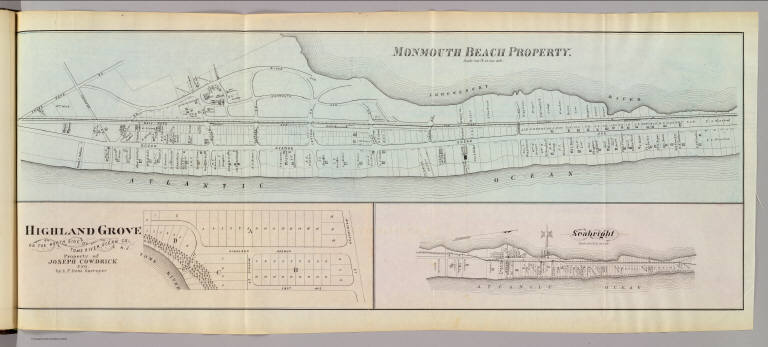
Monmouth Beach property. Highland Grove on the north side of Toms River, Ocean Co., N.J. Property of Joseph Cowdrick, Esq. by A.P. Irons, surveyor. Seabright. (Philadelphia, Woolman & Rose, 1878)
List No
1234.008
Note
Three hand col. lithographed maps. Monmouth Beach is at scale of 400 ft. to 1 in.; Seabright at 600 ft. to an in., and show buildings, landowners, etc.
Author
[Rose, Theodore F., Woolman, H. C.]
Full Title
Long Branch Graded School, Long Branch, N.J. (Philadelphia, Woolman & Rose, 1878).
List No
1234.009
Note
Lithographed view.
Author
[Rose, Theodore F., Woolman, H. C.]
Full Title
Oceanic. (with) Fair Haven. (Philadelphia, Woolman & Rose, 1878)
List No
1234.010
Note
Hand col. lithographed map, with inset. Fair Haven map at scale of 400 ft. to 1 in. Show buildings, landowners, etc.
|