|
Author
Johnson, A.J.
Full Title
Johnson's Pennsylvania And New Jersey Published By Johnson and Ward.
List No
0535.022
Note
In full color by county. Relief shown by hachures. Meridians Greenwich and Washington D.C.
Author
Mitchell, Samuel Augustus
Full Title
New Jersey Reduced From T. Gordon's Map By H.S. Tanner. Published By S. Augustus Mitchell, N.E. corner of Market & 7th Street Philada., 1846. Entered ... 1834 by T. Gordon ... New Jersey.
List No
0537.013
Note
Full color map by county with population figures over time.
Author
Mitchell, Samuel Augustus
Full Title
New Jersey, Reduced from T. Gordon's Map by H.S. Tanner. Published By S. Augustus Mitchell. N.E. corner of Market & 7th. Streets. Philada. 1848. Entered ... 1834 by T. Gordon ... New Jersey.
List No
0545.016
Note
Full color map, tinted by county. Explanation chart, showing symbols to roads, railroads, canals, land distances, and county towns. Prime meridian is Washington. Relief shown by hachures. Includes statistical tables.
Author
Mitchell, Samuel Augustus
Full Title
County Map Of Pennsylvania, New Jersey, Maryland, And Delaware. 18. (with) two insets of Philadelphia. 19. and City Of Baltimore. 20. Entered ... 1860, by S. Augustus Mitchell, Jr. ... Pennsylvania.
List No
0565.012
Note
Full color by county and outline by state. Street plans of Philadelphia and Baltimore shown.
Author
Mitchell, Samuel Augustus Jr.
Full Title
County map of New Jersey. (Scale: 1:1,100,000). County map of Maryland and Delaware. Drawn & Engraved by W.H. Gamble Philadelphia. (Scale: 1,550,000). Entered ... 1865 by S. Augustus Mitchell, Jr. ... Pennsylvania.
List No
0572.021
Note
Two color county maps on one page. Relief shown by hachures. Prime meridians are Greenwich and Washington, D.C.
Author
Mitchell, Samuel Augustus Jr.
Full Title
County map of New Jersey. (inset) 27. County map of Maryland and Delaware. Drawn and Engraved by W.H. Gamble Philadelphia. Entered ... 1867 by S. Augustus Mitchell, Jr. ... Pennsylvania.
List No
0579.021
Note
Color map by county. Relief shown by hachures. Prime meridians are Greenwich and Washington, D.C.
Author
Mitchell, Samuel Augustus
Full Title
Plan of the city of Philadelphia and Camden. Drawn and engraved by W.H. Gamble, Philadelphia. Entered ... 1879 by S. Augustus Mitchell ... Washington. (1880)
List No
0586.018
Note
Hand colored. Shows wards, major buildings, railroads, ferries, etc.
Author
Mitchell, Samuel Augustus
Full Title
County map of New Jersey. County map of Maryland and Delaware. Drawn and engraved by W.H. Gamble, Philadelphia. Entered ... 1879 by S. Augustus Mitchell ... Washington. (1880)
List No
0586.019
Note
Two hand colored maps. Relief shown by hachures. Show settlements, railroads, etc. Prime meridians: Greenwich and Washington.
Author
Mitchell, Samuel Augustus Jr.
Full Title
County map of the state of New Jersey. Copyright 1882, by Bradley & Company.
List No
0592.018
Note
Hand colored. Relief shown by hachures. Shows settlements, railroads, rivers, etc. Prime meridians: Greenwich and Washington.
Author
Mitchell, Samuel Augustus Jr.
Full Title
Plan of the city of Philadelphia and Camden. Drawn and engraved by W.H. Gamble. Copyright by S. Augustus Mitchell 1884.
List No
0592.021
Note
Hand colored. Relief shown by hachures. Shows wards, major buildings, railroads, ferries, etc.
Full Title
County map of the state of New Jersey. Copyright 1887 by Wm. M. Bradley & Bro. (1890)
List No
0594.017
Note
Hand colored. Relief shown by hachures. Shows settlements, railroads, rivers, etc. Prime meridians: Greenwich and Washington.
Full Title
Plan of the city of Philadelphia and Camden. Drawn and engraved by W.H. Gamble. Copyright 1887 by Wm. M. Bradley & Bro. (1890)
List No
0594.020
Note
Hand colored. Relief shown by hachures. Shows wards, major buildings, railroads, ferries, etc.
Author
[Morse, Charles W., Colby, Charles A.]
Full Title
New Jersey.
List No
0623.019
Author
Morse, Jedidiah
Full Title
A Map of New Jersey from the best Authorities. Published Sepr. 8th 1794 by J. Stockdale, Piccadilly.
List No
0632.012
Note
Without color.
Author
[Paullin, Charles O., Wright, John K.]
Full Title
Plate 160. Military History. The American Revolution, 1775 - 1783. 1775 - 1776. 1777. 1778 - 1779. Naval Battles, 1776 - 1800, War of the Revolution and War with France. The South, 1778 - 1779. The South, 1780. New York and New Jersey, 1780, Greene's Campaigns, 1781. 1781, Yorktown, 1781.
List No
0702.163
Author
[Reid, John, Winterbotham, W.]
Full Title
The State of New Jersey, Compiled from the most Accurate Surveys. Martin sculpt. Publish'd by John Reid.
List No
0845.011
Note
Uncolored.
Author
Scott, Joseph
Full Title
New Jersey.
List No
0887.005
Note
Uncolored.
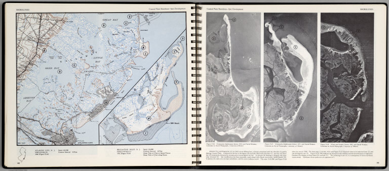
Author
[Scovel, James L., O'Brien, Emmett J]
Full Title
Shorelines. Coastal Plain Shorlines-Split Development. Atlantic City, N.J. (inset map) Brigantine Inlet, N.J. (with three aerial views on opposite page).
List No
0889.074
Note
Contour color maps, with location map and text. Aerial views of Atlantic city and Brigantine. Relief shown by contours and spot heights.
Author
Tanner, Henry S.
Full Title
New Jersey, Reduced from T. Gordon's Map by H.S. Tanner.
List No
0976.016
Author
Tanner, Henry S.
Full Title
New Jersey Reduced From T. Gordon's Map By H.S. Tanner. J. Knight Sc. Entered ... 1833 by H.S. Tanner ... Pennsylvania. Published by H.S. Tanner, Philadelphia. (above neat line) Tanner's Universal Atlas.
List No
0977.011
Note
State in full color by county with population statistics by county, town, and date. Route mileage charted from Trenton to numerous cities by stage and steamboat.
Author
Tanner, Henry S.
Full Title
Florida Canal ; Morris Canal N. J. ; Union Canal Pa. ; Schuylkill Navigation Penn. ; Profile of the Pennsylvania Canal. (with inset profile) Columbia railroad Pa. (to accompany) A Description of the Canals and Railroads of the United States.
List No
0979.006
Note
Six profiles on one page.
Author
Tanner, Henry S.
Full Title
New Jersey, Reduced from T. Gordon's Map by H.S. Tanner.
List No
0980.016
Author
Thomas, Cowperthwait & Co.
Full Title
(Covers to) New Jersey. Sold By Thomas, Cowperthwait & Co. No. 253 Market Street, Philada. 1845. Engraved by J.H. Young.
List No
0998.001
Note
Engraved by J.H. Young, this was first issued by Anthony Finley in 1834 - see our #5146. Full color map, folded into stamped red leather covers 12.5x8 with "New-Jersey" stamped in gilt. Prime meridians are Greenwich and Washington D.C.
Author
Thomas, Cowperthwait & Co.
Full Title
New Jersey. Sold By Thomas, Cowperthwait & Co. No. 253 Market Street, Philada. 1845. Engraved by J.H. Young.
List No
0998.002
Note
Engraved by J.H. Young, this was first issued by Anthony Finley in 1834 - see our #5146. Full color map, folded into stamped red leather covers 12.5x8 with "New-Jersey" stamped in gilt. Prime meridians are Greenwich and Washington D.C.
Author
Senex, John (c.1678-1740)
Full Title
A New Map of Virginia and the Improved Parts of Pennsylvania & New Jersey.
List No
10014.258
Author
L. Bamberger & Co.
Full Title
(Covers to) New Jersey
List No
10114.001
Note
Date estimated.
Author
L. Bamberger & Co.
Full Title
New Jersey
List No
10114.002
Note
Date estimated.
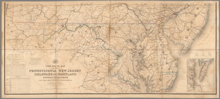
Author
United States. Post Office Department
Full Title
Upper Part Post Route Map of the States of Pennsylvania, New Jersey, Delaware, Maryland and of the District of Columbia.
List No
10436.002
Note
Updated to 1879 from 1869. 8 panels.
Author
United States. Post Office Department
Full Title
Lower Part Post Route Map of the States of Pennsylvania, New Jersey, Delaware, Maryland and of the District of Columbia.
List No
10436.004
Note
Updated to 1879 from 1869. 8 panels.
Author
United States. Post Office Department
Full Title
(Composite Map) Post Route Map of the States of Pennsylvania, New Jersey, Delaware, Maryland and of the District of Columbia.
List No
10436.005
Note
Updated to 1879 from 1869. 8 panels.
Author
U.S. General Land Office
Full Title
(Map 3 - Virginia, West Virginia, Ohio, Pennsylvania, Maryland, Delaware, New Jersey, New York, Rhode Island, Massachusetts, Connecticut).
List No
1071.005
Note
One of the series of adjacent sixteen maps. Mounted on linen. Relief shown in hachures.
Author
Des Rosiers, Leon L.
Full Title
Historical map of the state of New Jersey. Published by the Historical Map Bureau, W. Willington, Conn. Designed by Leon L. Des Rosiers.
List No
11378.000
Note
Color pictorial map of the state of New Jersey, borders with important historical events, places and famous people. Includes pictorial illustrations of various places, agricultural products, landmarks, industry, noted historical events, cities, towns, roads, airports, canals and railroads. Relief shown pictorially. Date estimated.
Full Title
Map of the compact portions of Philadelphia and Camden. (Published by Stedman, Brown & Lyon, Philadelphia), 1872.
List No
1155.026
Note
Hand col. lithographed map. Shows wards, major buildings, railroads, ferry routes, parks, cemeteries, etc.
Author
Meyer, Joseph, 1796-1856
Full Title
Die Staaten von New York, Pennsylvania, Maryland, New Jersey, Delaware & Virginia. 1850. Stahlstich (Direction v. Kleinknecht) aus der Schweinfurter Geographischen Graviranstalt des Bibliographischen Instituts zu Hildburghausen, Amsterdam, Paris u. Philadelphia. (in upper margin) Meyer's Zeitung Atlas. No. 70. (to accompany) Neuester Zeitungs-Atlas fur Alte und Neue Erdkunde. Herausgegeben von J. Meyer.
List No
11652.094
Note
Engraved outline hand color map of the Mid-Atlantic States. With 6 insets: New York and vicinity, Philadelphia and vicinity, Niagara Falls and vicinity, Albany and vicinity, Pittsburg and vicinity and Baltimore and Washington DC and vicinity. Shows administrative boundaries, cities and towns. Relief shown by hachures. Prime meridians are Greenwich and Washington.
Author
Seutter, Matthaeus, 1678-1756
Full Title
45. Pensylvania, Nova Jersey et Nova York.
List No
12040.111
Note
Date estimated.
Author
Goos, Pieter, 1616-1675
Full Title
Paskaerte van de Zuydt en Noordt Rever in Nieu Nederlant.
List No
12179.041
Author
[Weiland, Carl Ferdinand, 1782 -1847, Hassel, Georg, 1770-1829]
Full Title
Geographisch-statistische und historische Charte von Neu-Jersey.
List No
12293.011
Author
[Price, T. T., Rose, Theodore F., Woolman, H. C.]
Full Title
(Covers to) Historical and biographical atlas of the New Jersey coast. Proposed, arranged and illustrated by T.F. Rose. Surveys by H.C. Woolman. History and statistics by T.T. Price, M.D. Philadelphia, Woolman & Rose, 1878.
List No
1234A
Note
This is an outstanding combination of maps, views, and historical text. It is in the "county atlas" style of the period, but the choice of area (the New Jersey sea coast spanning several counties) is unusual. Maps hand painted and printed in full color. Atlas is bound in quarter leather burgandy cloth covered boards with "Historical & biographical atlas of New Jersey Coast illustrated. Woolman & Rose, 1879."
Author
[Price, T. T., Rose, Theodore F., Woolman, H. C.]
Full Title
(Title Page to) Historical and biographical atlas of the New Jersey coast. Proposed, arranged and illustrated by T.F. Rose. Surveys by H.C. Woolman. History and statistics by T.T. Price, M.D. Philadelphia, Woolman & Rose, 1878.
List No
1234B
Note
Illustrated lithographed title page. This is an outstanding combination of maps, views, and historical text. It is in the "county atlas" style of the period, but the choice of area (the New Jersey sea coast spanning several counties) is unusual. Maps hand painted and printed in full color. Atlas is bound in quarter leather burgandy cloth covered boards with "Historical & biographical atlas of New Jersey Coast illustrated. Woolman & Rose, 1879."
Author
[Geological Survey of New Jersey, Howell, George W.]
Full Title
The State of New Jersey, 1877. From U.S. Coast Survey records, N.J. geological and topographical surveys and various local surveys to date. Compiled and drawn by Geo. W. Howell, C.E. Geological Survey of New Jersey. Julius Bien lith. (Philadelphia, Woolman & Rose, 1878)
List No
1234.001
Note
Col. lithograph. Includes table of county and city population from 1875 census. Following title page.
Author
[Price, T. T., Rose, Theodore F., Woolman, H. C.]
Full Title
(Contents Page to) Historical and biographical atlas of the New Jersey coast. Proposed, arranged and illustrated by T.F. Rose. Surveys by H.C. Woolman. History and statistics by T.T. Price, M.D. Philadelphia, Woolman & Rose, 1878.
List No
1234C
Note
This is an outstanding combination of maps, views, and historical text. It is in the "county atlas" style of the period, but the choice of area (the New Jersey sea coast spanning several counties) is unusual. Maps hand painted and printed in full color. Atlas is bound in quarter leather burgandy cloth covered boards with "Historical & biographical atlas of New Jersey Coast illustrated. Woolman & Rose, 1879."
Author
[Rose, Theodore F., Woolman, H. C.]
Full Title
Corrugated iron steam yacht, Francis' patent, for His Highness the Nawab Nazim of Bengal (Moorshedaba). (with portrait of) Joseph Francis. (Philadelphia, Woolman & Rose, 1878).
List No
1234.002
Note
Lithographed view and portrait. Includes 3 insets "The hydraulic press," and exterior and sectional views of "Joseph Francis' life car."
Author
Giberson, William
Full Title
New Jersey, 1812. From Capt. Wm. Giberson's chart book Toms River, published by Thomas & Andrews, Boston. (with portrait of) Joseph Francis. (Philadelphia, Woolman & Rose, 1878). (Philadelphia, Woolman & Rose, 1878)
List No
1234.003
Note
Hand col. lithograph. Facsim. of 1812 map. Relief shown by hachures. Prime meridian: Philadelphia.
Author
[Rose, Theodore F., Woolman, H. C.]
Full Title
Barnegat Inlet. (with) Steamship Amerique, stranded ... January 7th, 1877, three miles north of Long Branch, N.J. (with) Steamer Rusland, stranded ... March 18th, 1877, at Long Branch, N.J. (Philadelphia, Woolman & Rose, 1878).
List No
1234.004
Note
Three lithographed views.
Author
[Rose, Theodore F., Woolman, H. C.]
Full Title
(Portraits of men of the New Jersey coast) John Arnold, D.R. Gowdy, J.T.B. Beekman, John Willits, Jacob Stults. (Philadelphia, Woolman & Rose, 1878).
List No
1234.005
Note
Five lithographed portraits.
Author
[Rose, Theodore F., Woolman, H. C.]
Full Title
(Portraits of men of the New Jersey coast) Robert Laird, John M. Brown, Benjamin D. Pearce, C.W. Maxson, O. Curtis. (Philadelphia, Woolman & Rose, 1878).
List No
1234.006
Note
Five lithographed portraits.
Author
[Rose, Theodore F., Ruff, C. E., Woolman, H. C.]
Full Title
(Coast section no. 1. Sandy Hook to Shark River). C.E. Ruff, Eng. (Philadelphia, Woolman & Rose, 1878)
List No
1234.007
Note
Hand col. lithograph. Relief shown by hachures; soundings in feet and fathoms.
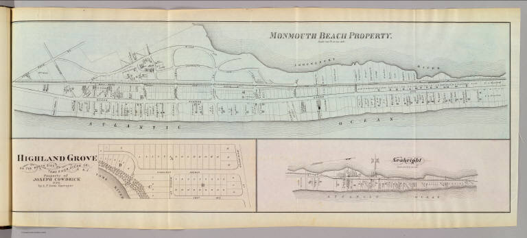
Author
[Irons, A. P., Rose, Theodore F., Woolman, H. C.]
Full Title
Monmouth Beach property. Highland Grove on the north side of Toms River, Ocean Co., N.J. Property of Joseph Cowdrick, Esq. by A.P. Irons, surveyor. Seabright. (Philadelphia, Woolman & Rose, 1878)
List No
1234.008
Note
Three hand col. lithographed maps. Monmouth Beach is at scale of 400 ft. to 1 in.; Seabright at 600 ft. to an in., and show buildings, landowners, etc.
Author
[Rose, Theodore F., Woolman, H. C.]
Full Title
Long Branch Graded School, Long Branch, N.J. (Philadelphia, Woolman & Rose, 1878).
List No
1234.009
Note
Lithographed view.
Author
[Rose, Theodore F., Woolman, H. C.]
Full Title
Oceanic. (with) Fair Haven. (Philadelphia, Woolman & Rose, 1878)
List No
1234.010
Note
Hand col. lithographed map, with inset. Fair Haven map at scale of 400 ft. to 1 in. Show buildings, landowners, etc.
|