|
Author
Johnson, Alvin Jewett, 1827-1884.
Full Title
Johnson's Philadelphia. Published by Alvin J. Johnson & Son, New York. Entered ... 1872, by A.J. Johnson ... New York. (to accompany) Johnson's New Illustrated Family Atlas Of The World ... MDCCCLXXX (1880). (inset) Philadelphia and vicinity.
List No
4830.075
Note
Engraved hand colored in outline plan of Philadelphia on 2 sheets. Shows wards and ward numbers, railroads, street names, ferry routes, city car routes, parks, some buildings and landmarks. Depth shown by isolines. Includes explanation.
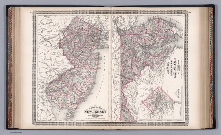
Author
Johnson, Alvin Jewett, 1827-1884.
Full Title
Johnson's New Jersey. Johnson's Delaware and Maryland. Published by Alvin J. Johnson & Son, New York. Entered ... 1868, by A.J. Johnson ... New York. (to accompany) Johnson's New Illustrated Family Atlas Of The World ... MDCCCLXXX (1880). (inset) District of Columbia.
List No
4830.076
Note
2 engraved hand colored in outline maps on 2 sheets, each 41x27 and 28x41. Depicts the area with color coding according to both county and district. The left hand map depicts New Jersey; Scale 1:650,000. The right hand map details Maryland and Delaware with an inset plan of the District of Columbia or Washington D.C., Scale 1: 950,000. Showing towns, villages, roads, railroads, rivers and mountain ranges. Relief shown by hachures. Prime meridians are Washington and Greenwich.
Author
Mitchell, Samuel Augustus
Full Title
New Jersey Reduced from T. Gordon's Map.
List No
4835.019
Author
Greenleaf, Jeremiah
Full Title
New-Jersey.
List No
4850.040
Note
Full color by county.
Author
[Morse, Sidney E. (Sidney Edwards), 1794-1871, Breese, Samuel]
Full Title
New Jersey. Entered ... 1841, by Sidney E. Morse and Samuel Breese ... New York. (New York: Published by Harper & Brothers, 1845). (to accompany) Morse's Cerographic Maps. No. VIII.
List No
4861.063
Note
Color wax engraved map. Shows capital, towns, road, railroads, rivers, canals, etc. Includes explanation. Relief shown by hachures. Prime meridians are Greenwich and Washington.
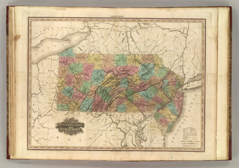
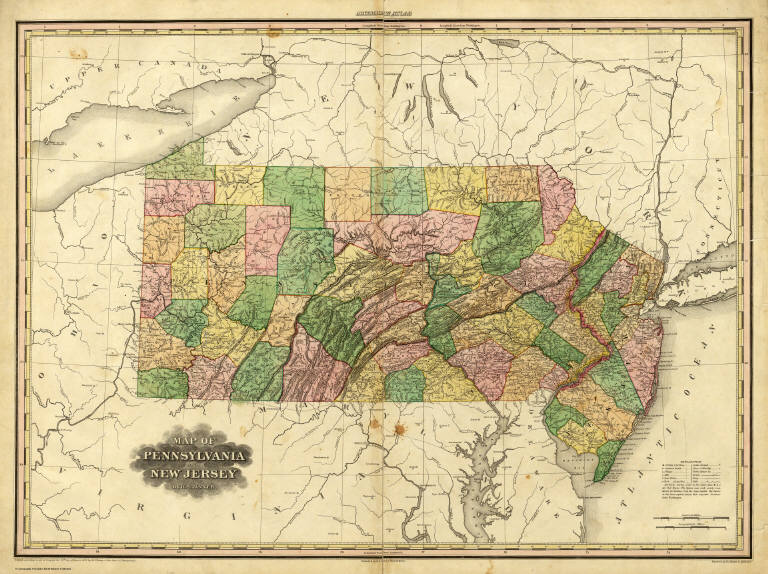
Author
Tanner, Henry S.
Full Title
Map of the Canals & Rail Roads of Pennsylvania and New Jersey and the Adjoining States. By H.S. Tanner. American Atlas. Engraved by H.S. Turner & Assistants. Entered according to Act of Congress, in the years 1833, by H.S. tanner, in the Clerk's Office of the Eastern District of Pennsylvania. Published by H.S. Tanner, Philadelphia.
List No
4862.016
Note
Engraved. Counties differentiated by full color. Relief shown by hachures.
Author
Carey, Mathew
Full Title
The State of New Jersey, Compiled from the most Authentic Information. Compiled by Samuel Lewis. Engraved by W. Barker.
List No
4863.032
Note
Uncolored except for small islands and the Flats in the Delaware Bay.
Author
[Carey, Mathew, Warner, Benjamin]
Full Title
New Jersey. (Engraved by) W. Barker, sculp.
List No
4864.018
Note
Prime meridians are from London and Philadelphia. Relief shown pictorially.
Author
Carey, Mathew
Full Title
New Jersey. Engraved by A. Doolittle New haven.
List No
4865.009
Note
Uncolored.
Author
Lucas, Fielding Jr.
Full Title
New Jersey. Drawn & Published by F. Lucas Jr., Baltimore. Kneass, sc. (1822)
List No
4866.040
Note
Engraved. Colored by county. Meridian Washington. Relief shown by sketches.
Full Title
Pennsylvania and New Jersey. (with) Philadelphia and its vicinity. N. & S.S. Jocelyn Sc. (New-Haven: N. & S.S. Jocelyn. 1823)
List No
4869.005
Note
Engraved map with inset and facing index page. Outline hand color. Relief shown by hachures. Prime meridians: Washington and Greenwich.
Author
[Hinton, Isaac Taylor, 1799-1847, Simpkin & Marshall]
Full Title
Map of the states of Pennsylvania and New Jersey. (with) Plan of Philadelphia. London, published March 15, 1832 by I.T. Hinton & Simpkin & Marshall. Engraved & printed by Fenner Sears & Co. (1832)
List No
4966.013
Note
Hand col. engraved map. Relief shown by hachures. Covers also Delaware. Prime meridians: Washington and Greenwich. "92."
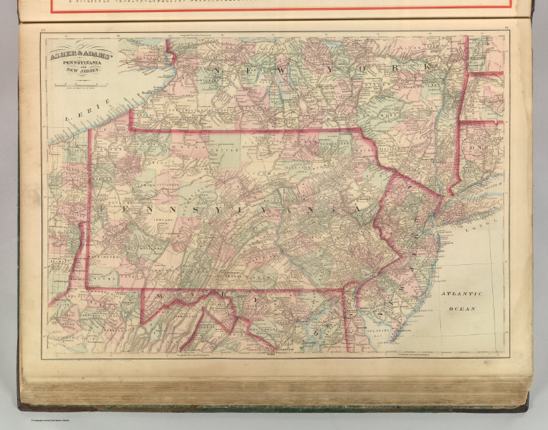
Author
Asher & Adams
Full Title
Asher & Adams' Pennsylvania and New Jersey. Entered according to Act of Congress 1874 by Asher & Adams in the Office of the Librarian of Congress at Washington.
List No
4977.016
Note
Washington Meridian. Hand tinted full color. Relief shown in hachures. Shows railroads, settlements, counties, waterways, and lakes. Engraved.
Author
Tanner, Henry S.
Full Title
Map of Pennsylvania and New Jersey By H.S. Tanner. Published by H.S. Tanner, Philadelphia. Engraved by H.S. Tanner & Assistants. Entered ... 20th day of August 1823, by H.S. Tanner... Pennsylvania. American Atlas.
List No
5022.024
Note
In full color by county.
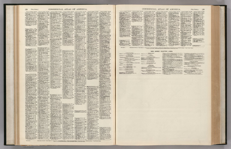
Author
Rand McNally and Company
Full Title
(Text Page) New Jersey - Counties, Brooks, Islands, Lakes, Mountains, Rivers, Towns,etc.
List No
5028AV
Note
Geographical features keyed to map; populations of towns. List of electric rail lines.
Author
Rand McNally and Company
Full Title
(Text Page) New Jersey - Counties, Brooks, Islands, Lakes, Mountains, Rivers, Towns,etc.
List No
5028AW
Note
Geographical features keyed to map; populations of towns. List of electric rail lines.
Author
Rand McNally and Company
Full Title
Commercial Atlas of America. Rand McNally Standard Map of New Jersey.
List No
5028.032
Note
Relief shown by hachures. Shows river navigability. List of railroads keyed to map. List of principal cities keyed to map.
Author
Rand McNally and Company
Full Title
Commercial Atlas of America. Rand McNally Black and White Mileage Map, New Jersey.
List No
5028.033
Note
Inset broad vicinity of New York City.
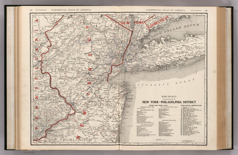
Author
Rand McNally and Company
Full Title
Commercial Atlas of America. Rand McNally Standard Map of New York-Philadelphia District.
List No
5028.035
Note
Shows railroads and electric rail lines.
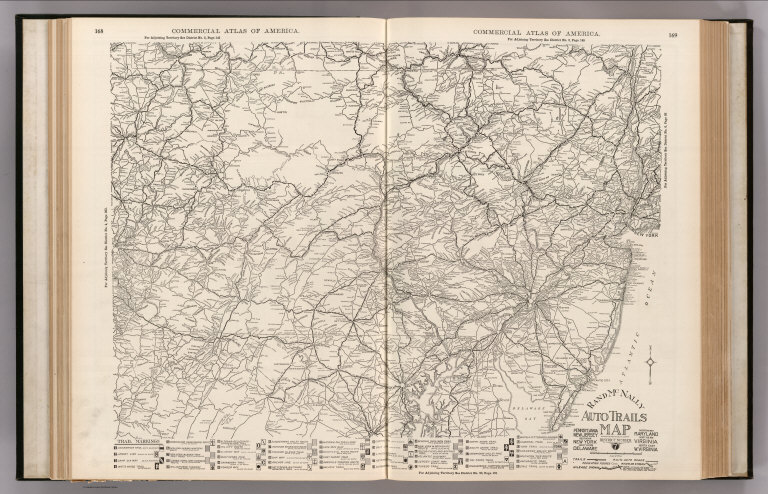
Author
Rand McNally and Company
Full Title
Commercial Atlas of America. Rand McNally Auto Trails Map. District No. 7. Pennsylvania, New Jersey, Southern New York, Northern Delaware, Northern Maryland, Northern Virginia, North East W. Virginia.
List No
5028.041
Note
Shows key to road numbers and trail markings.
Author
Mitchell, Samuel Augustus Jr.
Full Title
County Map of Maryland and Delaware. County Map of New Jersey. Entered ... 1874 by S. Augustus Mitchell ... Washington.
List No
5041.016
Note
Relief shown by hachures. Prime meridians are Washington D.C. and Greenwich.
Author
Finley, Anthony
Full Title
(Covers to) New Jersey. Philadelphia Published by A. Finley 1834 Engraved by J.H. Young.
List No
5146.001
Note
This is probably one of the last pocket maps issued by Finley - the map of New Jersey in the 1834 Finley General Atlas is single page, and this larger double page map issued here as a pocket map may have been intended for an unpublished later edition of the General Atlas. See the later issue of this map by Thomas, Cowperthwait & Company (our #998). Full color, folded into 12.5x8 dark brown leather covers with "New - Jersey." stamped in gilt. Prime meridians are Washington D.C. and Greenwich.
Author
Finley, Anthony
Full Title
New Jersey. Philadelphia Published by A. Finley 1834 Engraved by J.H. Young.
List No
5146.002
Note
This is probably one of the last pocket maps issued by Finley - the map of New Jersey in the 1834 Finley General Atlas is single page, and this larger double page map issued here as a pocket map may have been intended for an unpublished later edition of the General Atlas. See the later issue of this map by Thomas, Cowperthwait & Company (our #998). Full color, folded into 12.5x8 dark brown leather covers with "New - Jersey." stamped in gilt. Prime meridians are Washington D.C. and Greenwich.
Author
Tanner, Henry S.
Full Title
(Covers to) Map Of Pennsylvania And New Jersey. By H.S. Tanner. 1827. Published by H.S. Tanner, Philadelphia. Entered ... 1823, by H.S. Tanner ... Pennsylvania. Engraved by H.S. Tanner & Assistants.
List No
5152.001
Note
This is the American Atlas map of Pennsylvania and New Jersey, in transition to becoming the later more full blown canal map of 1830 (see our #3061). Several new canals are shown that do not appear on the atlas map of 1825: the Ohio Canal, Pennsylvania Canal, Union Canal, Hudson & Delaware Canal; completed and contemplated canals are shown in the Explanation, for the first time. Tanner was very interested in showing the growth of "internal improvements" in the states and the expansion of the canals of Pennsylvania in the period from 1825 to 1845 was shown progressively on a series of his maps (see also our #3942, 4551, and 4862 (1833 issue of the American Atlas with the Pennsylvania Canal map dated 1833). Map has outline color by county, and is folded into untitled red leather covers 15x8.5 with a border pattern stamped in gilt. Prime meridians are Washington D.C. and greenwich. Relief shown by hachures.
Author
Tanner, Henry S.
Full Title
Map Of Pennsylvania And New Jersey. By H.S. Tanner. 1827. Published by H.S. Tanner, Philadelphia. Entered ... 1823, by H.S. Tanner ... Pennsylvania. Engraved by H.S. Tanner & Assistants.
List No
5152.002
Note
This is the American Atlas map of Pennsylvania and New Jersey, in transition to becoming the later more full blown canal map of 1830 (see our #3061). Several new canals are shown that do not appear on the atlas map of 1825: the Ohio Canal, Pennsylvania Canal, Union Canal, Hudson & Delaware Canal; completed and contemplated canals are shown in the Explanation, for the first time. Tanner was very interested in showing the growth of "internal improvements" in the states and the expansion of the canals of Pennsylvania in the period from 1825 to 1845 was shown progressively on a series of his maps (see also our #3942, 4551, and 4862 (1833 issue of the American Atlas with the Pennsylvania Canal map dated 1833). Map has outline color by county, and is folded into untitled red leather covers 15x8.5 with a border pattern stamped in gilt. Prime meridians are Washington D.C. and greenwich. Relief shown by hachures.
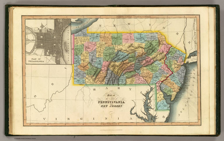
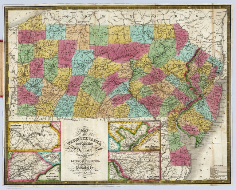
Author
Mitchell, Samuel Augustus
Full Title
(Covers to) Map Of Pennsylvania New Jersey And Delaware Compiled From the Latest Authorities. Philadelphia Published by S. Augustus Mitchell. 1832. (inset) Vicinity Of Pittsburgh. (inset) Lehigh And Schuylkill. Coal Regions. (inset) Vicinity Of Philadelphia. (inset) Vicinity Of Lancaster.
List No
5164.001
Note
This is a thoroughly revised second edition of the 1831 edition of this map: three inset maps of the vicinities of Philadelphia, Lancaster, and Pittsburgh are added along with a map of the Lehigh and Schuylkill Coal Regions, the title is reset with the word "compiled" replacing "constructed," and many new roads, towns, and distances are added. The inside front cover has a Census of 1830 listing for all three states. Map is full color, folded into red leather covers 13.5x8 with "Pennsylvania New Jersey & Delaware" and a border stamped in gilt. Prime meridian is Greenwich.
Author
Mitchell, Samuel Augustus
Full Title
Map Of Pennsylvania New Jersey And Delaware Compiled From the Latest Authorities. Philadelphia Published by S. Augustus Mitchell. 1832. (inset) Vicinity Of Pittsburgh. (inset) Lehigh And Schuylkill. Coal Regions. (inset) Vicinity Of Philadelphia. (inset) Vicinity Of Lancaster.
List No
5164.002
Note
This is a thoroughly revised second edition of the 1831 edition of this map: three inset maps of the vicinities of Philadelphia, Lancaster, and Pittsburgh are added along with a map of the Lehigh and Schuylkill Coal Regions, the title is reset with the word "compiled" replacing "constructed," and many new roads, towns, and distances are added. The inside front cover has a Census of 1830 listing for all three states. Map is full color, folded into red leather covers 13.5x8 with "Pennsylvania New Jersey & Delaware" and a border stamped in gilt. Prime meridian is Greenwich.
Author
Mitchell, Samuel Augustus
Full Title
Map Of Pennsylvania New Jersey And Delaware Compiled From the Latest Authorities. Philadelphia Published by S. Augustus Mitchell. 1832. (inset) Vicinity Of Pittsburgh. (inset) Lehigh And Schuylkill. Coal Regions. (inset) Vicinity Of Philadelphia. (inset) Vicinity Of Lancaster.
List No
5164.003
Note
This is a thoroughly revised second edition of the 1831 edition of this map: three inset maps of the vicinities of Philadelphia, Lancaster, and Pittsburgh are added along with a map of the Lehigh and Schuylkill Coal Regions, the title is reset with the word "compiled" replacing "constructed," and many new roads, towns, and distances are added. The inside front cover has a Census of 1830 listing for all three states. Map is full color, folded into red leather covers 13.5x8 with "Pennsylvania New Jersey & Delaware" and a border stamped in gilt. Prime meridian is Greenwich.
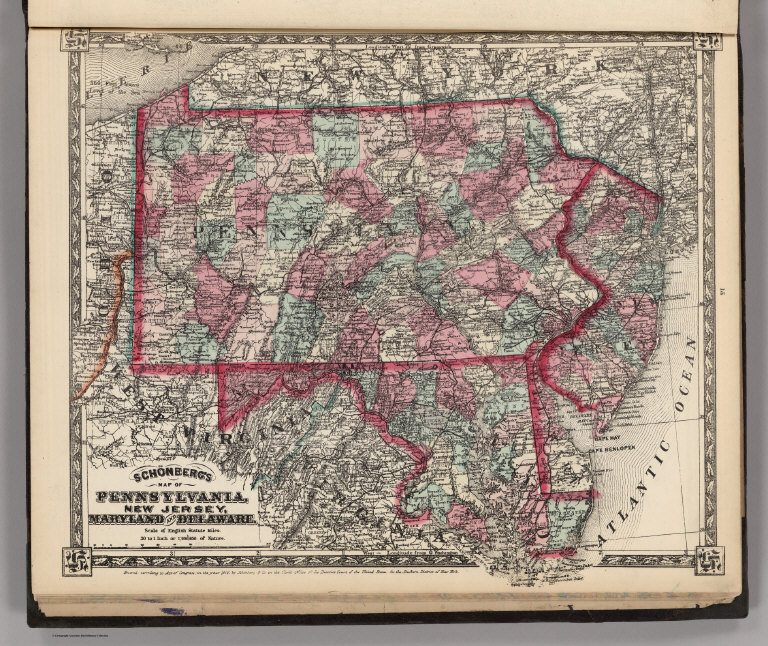
Author
Schonberg & Co.
Full Title
Schonberg's Map of Pennsylvania, New Jersey, Maryland and Delaware. Entered ... 1866 ...New York.
List No
5198.013
Note
Counties shown in color. Prime meridians Washington D.C. and Greenwich. Relief shown by hachures.
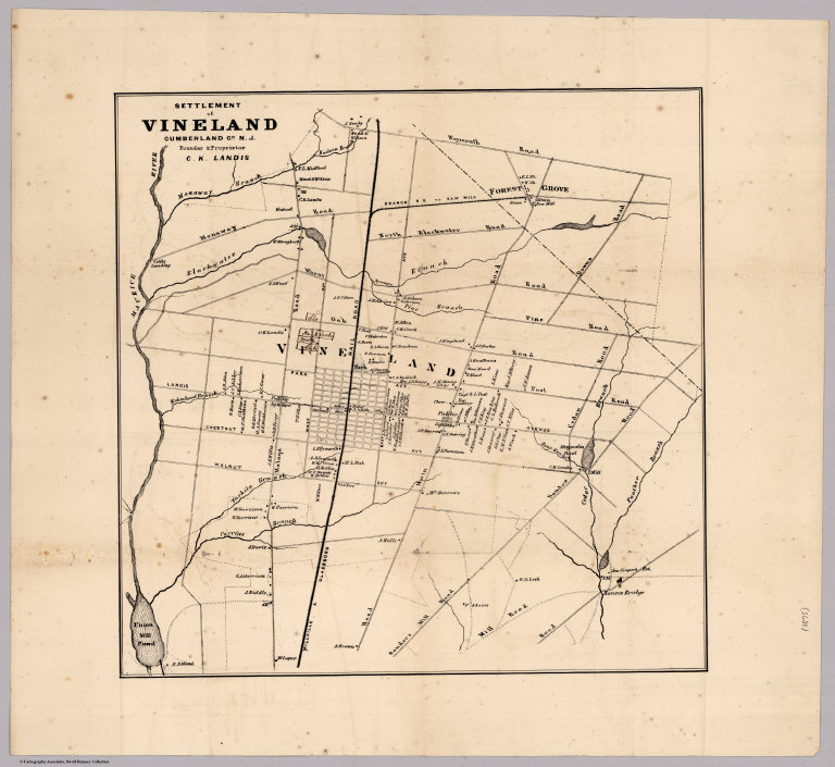
Landis, Charles K. (Charles Kline), 1835... Settlement of Vineland Cumberland County... 1875 5323.000 Related Author
Landis, Charles K. (Charles Kline), 1835-1900.
Full Title
Settlement of Vineland Cumberland Co. N.J. Founder & Proprietor C.K. Landis.
List No
5323.000
Note
This is an early example of a New Jersey railroad line suburban development map. The map is without color, showing roads, railroads, subdivisions and land ownership.
Author
Tanner, Henry S.
Full Title
New Jersey Reduced From T. Gordon's Map By H.S. Tanner. J. Knight Sc. Entered ... 1834 by H.S. Tanner ... Pennsylvania. Published by Carey & Hart, Philadelphia. (above neat line) Tanner's Universal Atlas.
List No
5363.013
Note
State in full color by county with population statistics by county, town, and date. Route mileage charted from Trenton to numerous cities by stage and steamboat. Engraved. Relief shown by hachures. Meridian Washington.
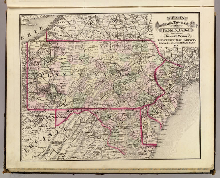
Author
Cram, George Franklin
Full Title
Cram's Rail Road & Township Map of Pa. Md. N.J. & Del. Published by Geo. F. Cram. Proprietor of the Western Map Depot. 66, Lake St. Chicago Ills. 1875.
List No
5370.001
Note
Map in full color by county. The railroad lines are clearly marked. (Note: The map has been rotated 90 degrees clockwise for readability.)
Author
Letts, Son & Co.
Full Title
Eastern United States. No. 7. Letts's popular atlas. Letts, Son & Co. Limited, London. (1883)
List No
5371.124
Note
Colored map. The 10-sheet set shows cities, British consular offices, railroads, canals, roads, lights and lighthouses, relief by hachures, etc. This sheet covers Maryland, New Jersey and parts of Pennsylvania, West Virginia, Virginia, New York and North Carolina.
Author
Tanner, Henry S.
Full Title
Map of Pennsylvania and New Jersey By H.S. Tanner. Published by H.S. Tanner, Philadelphia. Engraved by H.S. Tanner & Assistants. Entered ... 20th day of August 1823, by H.S. Tanner... Pennsylvania. American Atlas.
List No
5388.016
Note
In full color by county.
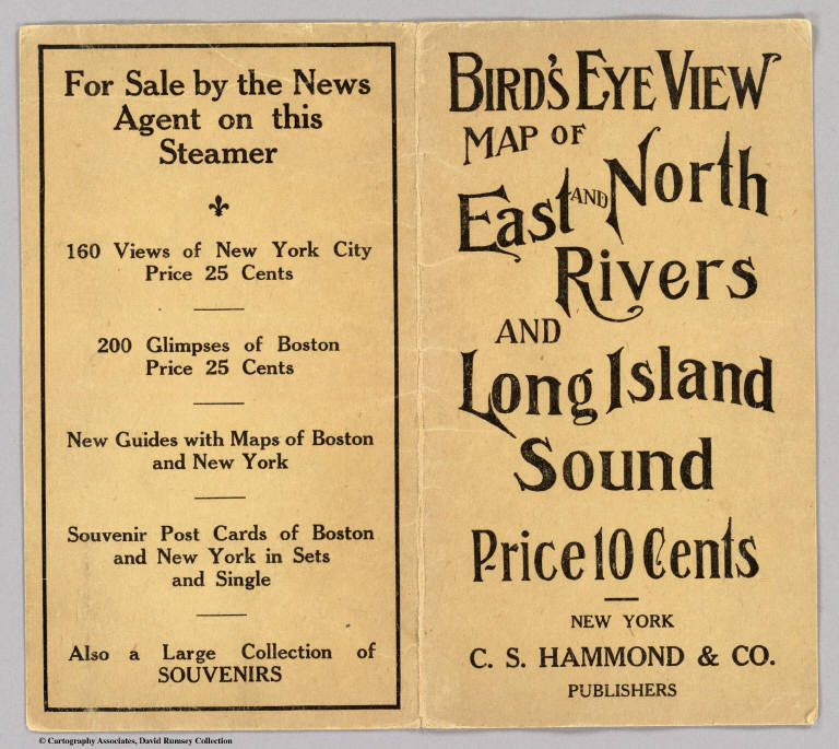
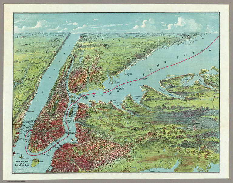
Author
Hammond, C.S.
Full Title
(Covers to) Birds Eye View Map Of New York And Vicinity Copyright 1909 by C. S. Hammond & Co., N. Y. Drawn & Printed By C. S. Hammond & Co., N. Y.
List No
5434A
Author
Hammond, C.S.
Full Title
Birds Eye View Map Of New York And Vicinity Copyright 1909 by C. S. Hammond & Co., N. Y. Drawn & Printed By C. S. Hammond & Co., N. Y.
List No
5434.001
Note
Full color birds eye view from Yonkers to South Norwalk in the north and from Freeport to Ellis Island in the south. Brown paper covers printed in black entitled "Bird's Eye View Map Of East And North Rivers And Long Island Sound Price 10 Cents - New York C.S. Hammond & Co. Publishers."
Author
Ensign, Bridgman & Fanning
Full Title
Our Nation's Camp Ground. Published By Ensign, Bridgman & Fanning, 156 William Street, N.Y. (with) Two inset maps of the Mid-Atlantic States and Washington. (with) 6 inset pictures.
List No
5438.000
Note
Full county color on the Mid-Atlantic map and partial color on the Washington inset. Inset pictures include: 2 drawings entitled "Star Spangled Banner" and "The Outrage On The American Flag At Fort Sumter"; 3 figures including a man holding the U.S. flag, Justice captioned "Justice Disarmed" and Liberty wrapped in the flag with the caption "Liberty Weeping"; 1 drawing of citizens saluting the flag, constitution & laws. Quote at top reads, "If any one attempts to haul down the American Flag shoot him on the spot."--Gen. John A. Dix.
Author
Colton, G.W.
Full Title
New Jersey. No. 19. Published by J.H. Colton & Co., No 172 William St., New York. Entered according to the Act of Congress in the year 1855 by J.H. Colton & Co. in the Clerk's Office of the District Court of the United States for the Southern District of New York.
List No
5479.042
Note
Meridian Washington (D.C.). Counties tinted in color.
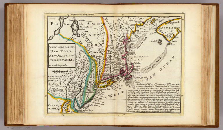
Author
Moll, Herman, d. 1732
Full Title
New England, New York, New Jersey and Pensilvania. By H. Moll, Geographer. (Printed and sold by Tho: Bowles next ye Chapter House in St. Pauls Church Yard, & Ino: Bowles at ye Black Horse in Cornhill, 1736?)
List No
5580.049
Note
Hand col. engraved map. Includes geographical note.
Full Title
New Jersey. (Written and engraved by Jos. Perkins. 1845)
List No
5745.042
Note
Engraved map. Hand colored. Relief shown pictorially. Shows railroads, canals, etc. Prime meridians: Washington and Greenwich.
Author
Rand McNally and Company
Full Title
Rand McNally junior auto road map New Jersey. Copyright by Rand McNally & Co., Chicago, Ill. (1927)
List No
5755.007
Note
Color map. Relief shown by hachures. Shows settlements, classified roads with distances, etc. "I-7."
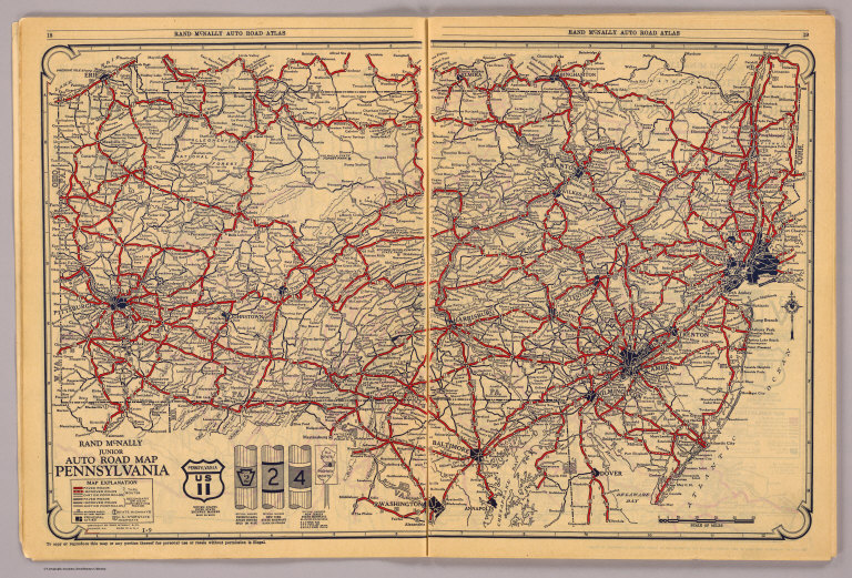
Author
Rand McNally and Company
Full Title
Rand McNally junior auto road map Pennsylvania. Copyright by Rand McNally & Co., Chicago, Ill. (1927)
List No
5755.008
Note
Color map. Relief shown by hachures. Covers also New Jersey and parts of adjacent states. Shows settlements, classified roads with distances, etc. "I-9."
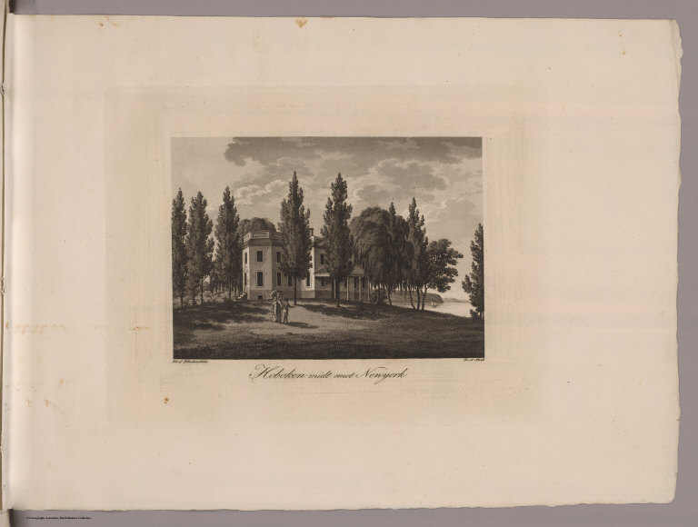
Author
Klinckowstrom, Axel Leonhard
Full Title
New York med Trakten Daromkring. (Stockholm: Stente af C. Muller, 1824)
List No
5757.010
Note
Engraved map of New York and vicinity.
Author
Klinckowstrom, Axel Leonhard
Full Title
Inrednings ritning till ett vanligt litet boningshus af trad i Newyork, Newyerssey och Pensylvania Staterne. (Stockholm: Stente af C. Muller, 1824)
List No
5757.012
Note
Engraved building plans.
Author
Klinckowstrom, Axel Leonhard
Full Title
Hoboken midt emot Newyork. Rit. af Klinckowstrom. Gr. af Akrell. (Stockholm: Stente af C. Muller, 1824)
List No
5757.016
Note
Engraved "... view of the old Stevens house at Hoboken."--Stokes.
Full Title
County map of the state of New Jersey. Copyright 1886 by Wm. M. Bradley & Bro.
List No
5784.017
Note
Hand colored. Relief shown by hachures. Shows settlements, railroads, rivers, etc. Prime meridians: Greenwich and Washington.
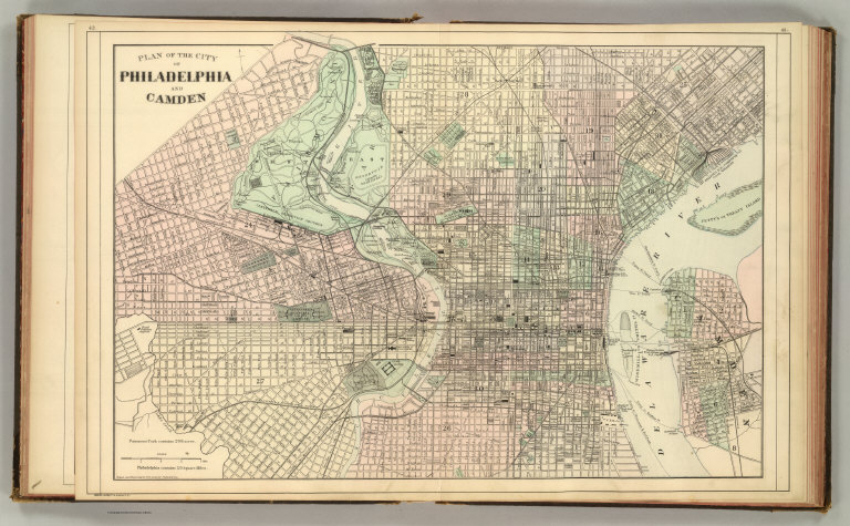
Full Title
Plan of the city of Philadelphia and Camden. Drawn and engraved by W.H. Gamble. Copyright 1886 by Wm. M. Bradley & Bro.
List No
5784.020
Note
Hand colored. Relief shown by hachures. Shows wards, major buildings, railroads, ferries, etc.
Author
Rand McNally and Company
Full Title
(Covers to) Rand, McNally & Co.'s New Shippers' Railroad Map of the United States. Scale: 8 miles to one inch. Showing all railroads, each in a separate color, and all railroad stations in large, plain type. This is the New York section, only, of the above-named map. (Below the neatline) Rand, McNally & Co.'s New Shippers' Railroad Map of the United States, Copyright, 1888 by Rand, McNally & Co. Copyright, 1891 by Rand, McNally & Co.
List No
5802L
Note
This is the New York, Pennsylvania, New England section of the larger map.
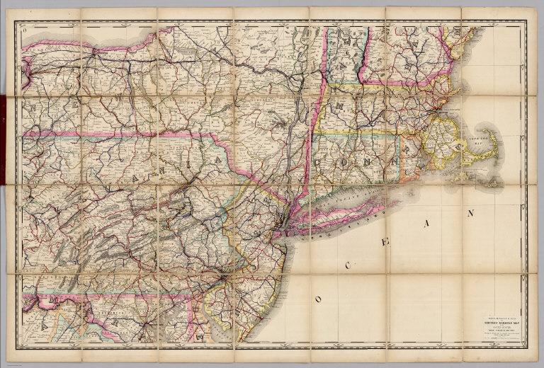
Author
Rand McNally and Company
Full Title
Rand, McNally & Co.'s New Shippers' Railroad Map of the United States. Scale: 8 miles to one inch. Showing all railroads, each in a separate color, and all railroad stations in large, plain type. This is the New York section, only, of the above-named map. (Below the neatline) Rand, McNally & Co.'s New Shippers' Railroad Map of the United States, Copyright, 1888 by Rand, McNally & Co. Copyright, 1891 by Rand, McNally & Co.
List No
5802.012
Note
This is the New York, Pennsylvania, New England section of the larger map.
Author
Shell Oil Company
Full Title
Shell Map of New Jersey (cover title). Shell Highway Map of New Jersey. 9-DD-1956-2. (inset) Atlantic City.
List No
5840.057
|