|
Author
Rand McNally and Company
Full Title
Rand McNally standard map of Nevada. With air trails. No. 1:27S. 7 R29. (to accompany) Rand McNally standard indexed and air trails maps of Nevada ... Copyright, 1930, by Rand McNally & Company, Chicago.
List No
11981.003
Note
Air trails map of Nevada, state and county boundaries in outline color. Shows major cities, state capital, county seats, cities, towns, airports, seaplane ports, revolving beacon lights, etc. Includes Air trails legend, wind rose and index to principal cities. Prime meridian is Greenwich. Relief shown by hachures.
Author
Rand McNally and Company
Full Title
Rand McNally standard map of Nevada. No. 1:27S. 7 R29. (to accompany) Rand McNally standard indexed and air trails maps of Nevada ... Copyright, 1930, by Rand McNally & Company, Chicago.
List No
11981.004
Note
Railroad map of Nevada, state and county boundaries in outline color. Shows major cities, state capital, county seats, cities, towns, railroads and electric lines. Includes index to principal cities and list of Nevada railroads. Prime meridian is Greenwich. Relief shown by hachures.
Author
[Thomas, George Coupland, Thomas Bros.]
Full Title
California and Nevada. (to accompany) Thomas Bros. map of the city & county of San Francisco. Copyright by Geo. C. Thomas. Compiled and published by Tohmas Bros... Oakland 12, Calif. (Cover title) Thomas Bros. San Francisco info-guide and complete detailed colorful street map. Copyright 1945 by George Coupland Thomas.
List No
11147.006
Note
Uncolored map. Showing state boundaries, highways, roads, parks, cities and towns.
Author
[Thomas, George Coupland, Thomas Bros.]
Full Title
(Composite text) Thomas Bros. map of the city & county of San Francisco. Copyright by Geo. C. Thomas. Compiled and published by Tohmas Bros... Oakland 12, Calif. (Cover title) Thomas Bros. San Francisco info-guide and complete detailed colorful street map. Copyright 1945 by George Coupland Thomas.
List No
11147.007
Note
Color map, 54 x 67, folded in green heavy paper cover 19 x 11, with title "San Francisco info-guide and complete detailed colorful street map". With 60 pages of street index, text and index to points of interest, uncolored views, and 5 maps. Map showing city boundaries, address block numbers, schools, parks, street car routes, cable car and bus lines and points of interest. Relief shown by hachures.
Author
Cram, George Franklin, 1841-1928
Full Title
Nevada. 1899, by Geo. F. Cram.
List No
14372.200
Note
Map of Nevada. Shows political boundaries, counties, towns, railroads, topography, bodies of water, drainage, coastlines and islands. Relief shown with hachures. Includes key with explanation, latitudinal and longitudinal lines, as well as a bar scale given in miles. With alphanumeric grid corresponding to "Index of Nevada" on page 371. Colored lithograph. Map is 55 x 39 cm, on double sheet 67 x 45 cm. "Index of maps" and "Index of cities" in margins, providing navigation for atlas as a whole.
Author
Cram, George Franklin, 1841-1928
Full Title
(Composite Map to) California and Nevada : Northern half. -- California and Nevada : Southern half. 1899, by Geo. F. Cram.
List No
14372.205
Note
Composite map of California and Nevada (northern and southern halves). Shows political boundaries, counties, towns, railroads, topography, bodies of water, drainage, coastlines and islands. Relief shown with hachures. Includes keys with explanations, latitudinal and longitudinal lines, as well as bar scales given in miles. With alphanumeric grid corresponding to "Index of Nevada" on page 371; "Index of California" on pages 374-375, 378-379 and 382. Colored lithograph. Together, maps are 82 x 57 cm, on two double sheets 90 x 67 cm. "Index of maps" and "Index of cities" in margins, providing navigation for atlas as a whole.
Author
Mid-West Map Company
Full Title
Highway map & guide of California & Nevada. Mid-West Map Co. Aurora, Mo.
List No
14409.002
Note
Pocket road map for the states of California and Nevada. Shows state boundaries, cities, highways, roads, airports, parks, topography, bodies of water, drainage and coastline. Relief shown with hachures. Includes explanatory text, a legend, bar scale given in miles, and compass rose with north oriented toward top of sheet. Indexed, with key on verso. Advertisements in margins. Printed in blue. Map is 53 x 40 cm, on sheet 56 x 44 cm.
Author
[Von Schmidt, Allexey W., Muybridge, Edward, Thomas Houseworth & Co,, Leicht, F. Von, Hoffmann, J.D.]
Full Title
(Sheet 1) Map of the Eastern Boundary of the State of California being that Portion of the 120th Degree of Longitude West of Greenwich lying between the 42nd & 39th Degrees of North Latitude As Surveyed under Contract dated 20th July A.D. 1872 . . . by Allexey W. Von Schmidt . . .
List No
15335.003
Author
[Von Schmidt, Allexey W., Muybridge, Edward, Thomas Houseworth & Co,, Leicht, F. Von, Hoffmann, J.D.]
Full Title
(Sheet 2) Map of the Eastern Boundary of the State of California being that Portion of the 120th Degree of Longitude West of Greenwich lying between the 42nd & 39th Degrees of North Latitude As Surveyed under Contract dated 20th July A.D. 1872 . . . by Allexey W. Von Schmidt . . .
List No
15335.004
Author
Furse, Peter R.
Full Title
Some of the Story of California & Nevada Together with a detail of the California Mission Trail (February 1962)
List No
15277.000
Author
[Fisher, Joseph R., Planters Peanuts (Firm)]
Full Title
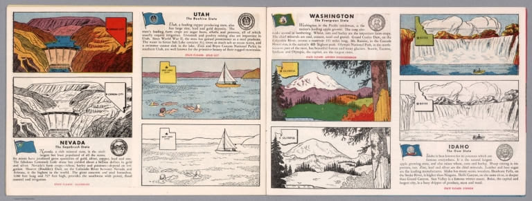
Nevada : The sagebrush state -- Utah : The beehive state -- Washington : The evergreen state -- Idaho : The gem state.
List No
14374.015
Note
Four views, representing Nevada, Utah, Washington and Idaho. Views show examples of the landscape and natural resources. Each view includes an inset map of the state, which marks the location of the capital city with a star. Accompanied by descriptive text, the state flags, seals and flowers: sagebrush, sego lily, western rhododendron and syringa, respectively. The view of each state appears both in color (on top) and in black and white (bottom), the latter inviting coloration. Together, views are 18 x 52 cm, on two sheets 20 x 54 cm.
Author
Clason Map Company
Full Title
Map Of Nevada And Southern California. 1907. The Clason Map Company, Publishers Of Advertising And Reference Maps Denver, Colorado. Price $5.00. The Denver Lith. Co. Denver, Colo. Copyrighted 1907 By Geo. S. Clason, Denver Colorado. (with 20 page index).
List No
3225.002
Author
Clason Map Company
Full Title
Map Of Nevada And Southern California. 1907. The Clason Map Company, Publishers Of Advertising And Reference Maps Denver, Colorado. Price $5.00. The Denver Lith. Co. Denver, Colo. Copyrighted 1907 By Geo. S. Clason, Denver Colorado.
List No
3660.002
Author
Fremont John Charles, 1813-1890
Full Title
The Pyramid Lake. Lith. by E. Weber & Co. Baltimore. (to accompany) Report of The Exploring Expedition to The Rocky Mountains in the Year 1842, and to Oregon & North California In The Years 1843-44. By Brevet Capt. J. C. Fremont ... Washington : Gales and Seaton, Printers. 1845.
List No
13406.020
Note
Lithograph map. Published by E. Weber & Co.
Author
Fremont John Charles, 1813-1890
Full Title
Pass in the Sierra Nevada of California. Lith. by E. Weber & Co. Baltimore. (to accompany) Report of The Exploring Expedition to The Rocky Mountains in the Year 1842, and to Oregon & North California In The Years 1843-44. By Brevet Capt. J. C. Fremont ... Washington : Gales and Seaton, Printers. 1845.
List No
13406.021
Note
Lithograph map. Published by E. Weber & Co.
Author
Fremont John Charles, 1813-1890
Full Title
(Map of the crossing of the Sierra Nevada by the South Fork of the American River). Lith. by E. Weber & Co. Baltimore. (to accompany) Report of The Exploring Expedition to The Rocky Mountains in the Year 1842, and to Oregon & North California In The Years 1843-44. By Brevet Capt. J. C. Fremont ... Washington : Gales and Seaton, Printers. 1845.
List No
13406.022
Note
Untitled folding map of the crossing of the Sierra Nevada. Published by E. Weber & Co.
Author
Geological Survey (U.S.)
Full Title
Central Pacific states.
List No
14359.026
Note
Map representing the Central Pacific States within the United States, as of 1970. Shows political boundaries, cities, railways, roads, ferry lines, Indian reservations, national forests and parks, mountains, mesas, valleys, deserts, bodies of water, drainage, coastlines and islands. Relief shown with labeling of mountain names and peak heights. Features population density for each city. Includes latitudinal and longitudinal lines, bar scale and scale statement. Presented with Albers Equal Area Projection. Colored lithograph. Map is 42 x 68 cm, on double sheet 49 x 71 cm. Index map and legend appear on page 5. Appears in General reference maps section.
Author
[Birdseye, C.H., Burchard, R.W., U.S. Geological Survey]
Full Title
(Composite map of) Sheets A - N. Plan and Profile of Colorado River From Lees Ferry, Ariz., To Black Canyon, Ariz.-Nev., and Virgin River, Nev. 21 Sheets (14 plans, 7 profiles).
List No
10974.001
Author
[Birdseye, C.H., Burchard, R.W., U.S. Geological Survey]
Full Title
Sheet A. Plan and Profile of Colorado River From Lees Ferry, Ariz., To Black Canyon, Ariz.-Nev., and Virgin River, Nev. 21 Sheets (14 plans, 7 profiles).
List No
10974.002
Author
[Birdseye, C.H., Burchard, R.W., U.S. Geological Survey]
Full Title
Sheet B. Plan and Profile of Colorado River From Lees Ferry, Ariz., To Black Canyon, Ariz.-Nev., and Virgin River, Nev. 21 Sheets (14 plans, 7 profiles).
List No
10974.003
Author
[Birdseye, C.H., Burchard, R.W., U.S. Geological Survey]
Full Title
Sheet C. Plan and Profile of Colorado River From Lees Ferry, Ariz., To Black Canyon, Ariz.-Nev., and Virgin River, Nev. 21 Sheets (14 plans, 7 profiles).
List No
10974.004
Author
[Birdseye, C.H., Burchard, R.W., U.S. Geological Survey]
Full Title
Sheet D. Plan and Profile of Colorado River From Lees Ferry, Ariz., To Black Canyon, Ariz.-Nev., and Virgin River, Nev. 21 Sheets (14 plans, 7 profiles).
List No
10974.005
Author
[Birdseye, C.H., Burchard, R.W., U.S. Geological Survey]
Full Title
Sheet E. Plan and Profile of Colorado River From Lees Ferry, Ariz., To Black Canyon, Ariz.-Nev., and Virgin River, Nev. 21 Sheets (14 plans, 7 profiles).
List No
10974.006
Author
[Birdseye, C.H., Burchard, R.W., U.S. Geological Survey]
Full Title
Sheet F. Plan and Profile of Colorado River From Lees Ferry, Ariz., To Black Canyon, Ariz.-Nev., and Virgin River, Nev. 21 Sheets (14 plans, 7 profiles).
List No
10974.007
Author
[Birdseye, C.H., Burchard, R.W., U.S. Geological Survey]
Full Title
Sheet G. Plan and Profile of Colorado River From Lees Ferry, Ariz., To Black Canyon, Ariz.-Nev., and Virgin River, Nev. 21 Sheets (14 plans, 7 profiles).
List No
10974.008
Author
[Birdseye, C.H., Burchard, R.W., U.S. Geological Survey]
Full Title
Sheet H. Plan and Profile of Colorado River From Lees Ferry, Ariz., To Black Canyon, Ariz.-Nev., and Virgin River, Nev. 21 Sheets (14 plans, 7 profiles).
List No
10974.009
Author
[Birdseye, C.H., Burchard, R.W., U.S. Geological Survey]
Full Title
Sheet I. Plan and Profile of Colorado River From Lees Ferry, Ariz., To Black Canyon, Ariz.-Nev., and Virgin River, Nev. 21 Sheets (14 plans, 7 profiles).
List No
10974.010
Author
[Birdseye, C.H., Burchard, R.W., U.S. Geological Survey]
Full Title
Sheet J. Plan and Profile of Colorado River From Lees Ferry, Ariz., To Black Canyon, Ariz.-Nev., and Virgin River, Nev. 21 Sheets (14 plans, 7 profiles).
List No
10974.011
Author
[Birdseye, C.H., Burchard, R.W., U.S. Geological Survey]
Full Title
Sheet K. Plan and Profile of Colorado River From Lees Ferry, Ariz., To Black Canyon, Ariz.-Nev., and Virgin River, Nev. 21 Sheets (14 plans, 7 profiles).
List No
10974.012
Author
[Birdseye, C.H., Burchard, R.W., U.S. Geological Survey]
Full Title
Sheet L Plan and Profile of Colorado River From Lees Ferry, Ariz., To Black Canyon, Ariz.-Nev., and Virgin River, Nev. 21 Sheets (14 plans, 7 profiles).
List No
10974.013
Author
[Birdseye, C.H., Burchard, R.W., U.S. Geological Survey]
Full Title
Sheet M. Plan and Profile of Colorado River From Lees Ferry, Ariz., To Black Canyon, Ariz.-Nev., and Virgin River, Nev. 21 Sheets (14 plans, 7 profiles).
List No
10974.014
Author
[Birdseye, C.H., Burchard, R.W., U.S. Geological Survey]
Full Title
Sheet N. Plan and Profile of Colorado River From Lees Ferry, Ariz., To Black Canyon, Ariz.-Nev., and Virgin River, Nev. 21 Sheets (14 plans, 7 profiles).
List No
10974.015
Author
Williams, Joseph E.
Full Title
California Nevada
List No
10901.000
Note
Lambert Conformal Conic Projection
Author
H.M. Gousha Company
Full Title
1937 road map of Nevada. Prepared exclusively for Standard Oil Company of California. Copyright by the H.M. Gousha Company, Chicago, Ill. Printed in U.S.A. 288-S.C. (to accompany) Standard Oil road map. C.J. Moody.
List No
9875.006
Note
Color map, double page. Shows roads, highways, trails, state parks, monuments, national forests, airports, drainage, distances, places of interest, etc. Includes legend and index to cities and towns. Includes RPM Motor Oil logo. Relief shown by hachures and spot heights.
Author
Raymo, Chet
Full Title
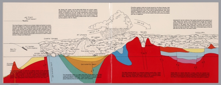
(California, Nevada). (to accompany) A geologic and topographic profile of the United States along interstate 80 : by Chet Raymo. 1982. Printed by Hubbard, Northbrook, IL.
List No
13323.006
Note
Geologic cross section and map. Covers the area from Pacific Ocean and San Francisco to Carson Sink, showing the volcanic peaks, fault zone, weather system, lakes, drainage, cities and mountains. Includes descriptive text.
Author
Rose, W.
Full Title
W. Rose's revised chart of the Comstock mines and Sutro Tunnel, State of Nevada. Compiled & Drawn by W. Rose. Published by Payot, Upham & Co., San Francisco. A. Waldstein, Lith. S.F. Entered According Act of Congress in the Year 1878 ... Washington, D.C. (inset profile view) Sutro Tunne. (with view) The Mouth of Sutro Tunnel.
List No
13018.000
Note
Revised map of part of Nevada. Representing Comstock mines and the position of the Sutro Tunnel and the counties surrounding it. Shows mining claims, location of mineral veins, counties, roads, flumes, railroad, Indian reservations, and the Sutro Tunnel. Towns or settlements of Silver City, American Flat, Gold Hill Town, Virginia City, and Flowery Ridge. Includes small vignettes of buildings, structures, and mountain peaks. Relief shown pictorially. The Comstock Lode, a huge vein of silver discovered in 1857 under Nevada’s Mount Davidson, was the greatest precious-metal discovery since gold was found in California in 1848. Sutro Tunnel, conceived by German engineer Adolph Sutro (1830-98) as a means of draining off the huge quantities of water infiltrating the ever-deeper shafts. Constructed under Sutro’s leadership between 1869 and 1878, the tunnel extended several miles from Mount Davidson to its exit on a piece of land granted to Sutro in the vicinity of Dayton.
Author
Guillemin-Tarayre, Edmond
Full Title
Carte Panoramique de la Region metallifere de Washoe (Etat de Nevada) par E. Guillemin-Tarayre. Cette carte est executee en projection gnomonique sur l'horizon du Mt. Davidson. Grave chex Erhard, Paris - Impr. Lemercier r. de Seine 57.
List No
11309.000
Note
Early map of Lake Tahoe and the Washoe Mining District on a Gnomonic Projection. One of the earliest geological and mining map of the region. Centered on Virginia City and extending to the Truckee River, Lake Tahoe, the Walker River and the Carson River. The outer ring of mountains locates Sevier Mountain, Pyramid Peak, Mt. Washoe, the Valley of the Carson River, and "Massif Palmyra." Towns named on the map include Washoe City, Fort Churchill, Genoa, Carson, with several dozen mines also named. Relief shown pictorially, by hachures and spot heights. Includes key to geological formation and notes. Guillemin-Tarayre's map is part of a rare set of scientific works published by the French government.
Author
[Vischer, Edward, Cooper, J.J.]
Full Title
(Text Page) Panorama from the Summit of Mount Davidson, Washoe Range.
List No
8715.001
Note
Informative text as to how the map came to be created and an explanation of the visible area.
Author
[Vischer, Edward, Cooper, J.J.]
Full Title
Panorama from the Summit of Mount Davidson, Washoe Range.
List No
8715.002
Note
Unusual 360 degree perspective bird's eye view as seen from summit of Mount Davidson, the site of the famous Comstock Mines and Virginia City in Nevada. Attractive vignettes of mining camps.
Author
Rude, Klengston
Full Title
Pano-view map : California, Nevada. Progressive. Historical. Spectacular. Recreational. Kleng Rude. C(opyright) 1962 Kleng Rude Studios, Long Beach.
List No
8547.000
Note
Detailed pictorial panoramic view of California and Nevada, with decorative border, mounted on cardboard. On upper and lower margins, vignettes of explorers, missionaries, and pioneers, with chronological history of California and Nevada, also showing California States and Nevada State birds and flowers. Map shows state parks, wild life habitats, recreational areas, agriculture, minerals, missions, Indian reservations, military bases, roads, railroads, etc. Includes state flags, State symbols, legend and text.
Author
[Gibbes, C.D., Holt, Warren]
Full Title
Map of the States of California and Nevada. Carefully Compiled from the Latest Authentic Sources. California by Julius H. Von Schmidt, Arthur W. Keddie, and C.D. Gibbes, C.E.'s. Nevada by Chas. Drayton Gibbes C.E. Comprising Information obtained from the U.S. Coast and Land Surveys; State Geological Surveys, By Prof. J.D. Whitney; Railroad Surveys And The Results of Explorations Made By Brevet Lieut. Col. R.S. Williamson, U.S.A., Henry DeGroot, C.D. Gibbes, And Others. Entered ... 1876 by Warren Holt ... California.
List No
6716.000
Note
Third (?) edition. Some changes from the 1871 edition. Wheat does not list editions later than 1869, and Vogdes only lists 1869, 1876, and 1882.
Author
Russell, Israel C. (Israel Cook), 1852-1906.
Full Title
Lake Lahontan : a quaternary lake of northwestern Nevad, by Israel C. Russell. Assisted by A.L. Webster, W.D. Johnson, cartographers ; W.J. McGee. GEO. M. Wright, geologists. Mountain shading, by W.J. Hays. Topography compiled by Eugene Rickseker ... (to accompany) Geological history of Lake Lahontan : a quaternary lake of Northwestern Nevada. (series title) Department of Interior : Monographs of the United States Geological Survey, vol. XI. (on upper margin) U.S. Geological Survey; Lake Lahontan PL. XLVI.
List No
0866.051
Note
Color map. Showing quaternary lakes, existing lakes and playas. Relief shown by contours and shadings. "Contours 1000 feet interval". Shows footprint of buildings and railroads.
Author
[California Geological Survey, Hoffmann, Charles F., Whitney, J.D.]
Full Title
(Composite) Topographical Map of Central California Together With a Part of Nevada. (Sheets I, II, III & IV). State Geological Survey Of California. J.D. Whitney, State Geologist. C.F. Hoffmann, Principal Topographer, V. Wackenreuder, J.T. Gardner, A. Craven, A.D. Wilson, Field Assistants. 1873 ... Julius Bien, Engr.
List No
2546.006
Note
Four sheets. South 2 sheets of 4; top 2 sheets apparently were never issued but were printed. Four unmounted sheets on heavy paper. Never folded.
Author
Bancroft, A.L.
Full Title
Bancroft's new map of California and Nevada : compiled from the latest and most reliable official sources and special surveys.
List No
6724.002
Note
Includes a unique birdseye view of Virginia City, Nevada. This map derives from H. H. Bancroft's 1867 Map of the Pacific States (see our 2549.000) but now focuses on just California and Nevada and the extensive and growing mining activity and transportation networks in those states. It is an entirely new engraving from the earlier map series and uses color lithography. With an inset map, Railway Map of the Pacific States.
Author
Bancroft, A.L.
Full Title
Bancroft's Map Of California, Nevada, Utah And Arizona. Published By A.L. Bancroft & Compy. Booksellers & Stationers, San Francisco, Cal. 1873. Entered ... by A.L. Bancroft & Company ... Washington, D.C.
List No
0046.000
Note
1st edition was 1864. From Bancroft's Map the of Pacific States which appeared in 1863. Wheat says Bancroft changed the large Pacific States map in 1870, but we believe that the smaller maps such as this continue to be from the original 1863 or 1867 plates, updated to show railroad expansion and topographical changes. With black top and bottom rollers. Full color by county.
Author
[Craven, A., Hoffman, Hoffmann, C.F., Leicht, F., Geological Survey of California]
Full Title
State Geological Survey Of California, J.D. Whitney, State Geologist. Map Of California And Nevada. Drawn By F.v. Leicht And A. Craven ... J. Bien, Lith. N.Y. 2nd edition Revised by Hoffmann and Craven and issued by authority of the Regents of the University of California given May 12th 1874.
List No
0115.000
Note
1st edition was 1873. Under the title is the following Note: "In the compilation of this map the following materials were used. For California: The work of the State Geological Survey and that of the U.S. Coast and Land Surveys. For Nevada: The work of the Fortieth Parallel Survey, under Clarence King, the U.S. Engineer Explorations under Williamson and Wheeler; the Central Pacific Railroad Survey under Butler Ives; and the work of the California Survey, by Wackenreuder, Craven, Wilson and Loehr from 1863 to 1872." Full printed color. Map is dissected into 54 sections and mounted on linen. Folds into a tan cloth folding case 19x13 with "California & Nevada California Geological Survey 1874" stamped in gold on the spine.
Author
Vincent
Full Title
Map Of The State Of California. Compiled from the most recent surveys and explorations Containing all the latest discoveries and newest towns. By Vincent. Printed by Mangeon S. Jacques St. Engraved by Ch. Smith. (inset) San Francisco and its surrounding localities. 1860.
List No
1124.000
Note
Unusual map showing California on its side with north to the left, an inset map and a beautiful view titled "Panorama Of San Francisco and Contra Costa." Full color by county.
Author
Goodwin, F.A.
Full Title
Map Of California And The Adjacent Country. Compiled by F. Goodwin From the best Authors and actual Observation. Entered ... 1855 by F. Goodwin ... New York. Lith. of Geo. E. Leefe, 223 Fulton St. N.Y. (with 8 page description) A Brief Description of California, From The Time of Its First Occupation by the United States and Subsequent Growth ... Accompanied by a Map of California and adjacent Country.
List No
3438.001
Note
Wheat calls this "rare but otherwise unimportant," due to some misspellings and inaccuracies in the map. Streeter sale illustrates the map and the price realized was the same as the Eddy map of 1853. I find the Wheat inaccuracies minor, with most of them being misspellings. The overall map is impressive. It would be interesting to find the map or maps that were used as sources. Ouline color by state. Folded into dark brown cloth covers 16.5x11 with "Map Of California And Adjacent Country By F. Goodwin" stamped in gilt.
Author
[DeGroot, Henry, Holt, Warren]
Full Title
DeGroot's Map Of Nevada Territory Exhibiting A Portion Of Southern Oregon & Eastern California With County Boundaries, Mining Districts, Railroad Routes, Wagon Roads, Table Of Distances, &c. &c. Published By Warren Holt, 305 Montgomery St. San Francisco, Cal. 1863. Entered ... 1862 by Warren Holt ... California.
List No
3453.000
Note
Very scarce detailed map of the early Nevada Territory. Wheat: "DeGroot's 'Nevada' of 1863 is truly an impressive performance...cartographical pioneering of the first order." Wheat believed that the map may have actually been published in 1862 (the date of its copyright) but dated 1863 to be up to date, because it shows the eastern boundary of Nevada at the 116th meridian instead of the 115th which was made the boundary in July of 1862. Much is shown in Nevada, but also in western California, Southern Oregon (the Owyhee is "unexplored") and a small corner of Washington Territory (now Idaho). According to Wheat, DeGroot had extensive first hand knowledge of the entire area and the map displays this with great clarity. What is unusual about this map is its sense of accuracy - it looks like nothing has been put in that the author was not sure of - much like Arrowsmith's maps of the early 1800's. W.H. has the Howell copy with DeGroot's printed Guide to the map mentioned by Wheat and Wagner Camp; probably the only copy of the map existing with the guide, and the only copy of the guide. Map is in full color by county.
Author
Appleton, D. & Co.
Full Title
Map of California and Nevada. Copyright 1891 by Matthews-Northrup Co. ... Buffalo, New York. (insets) Map of Alaska; Map of Hawaiian Islands; San Francisco and vicinity. (to accompany) The Library Atlas Of Modern Geography ... New York, D. Appleton And Company 1892. (on upper margin) California, Nevada, Alaska and Hawaiian Islands. 55.
List No
0026.141
Note
Color map. Shows county boundaries and county seat, capital, railways, roads, etc. "Size of type indicates importance of the places". Includes notes. Relief shown by hachures and spot heights. Prime meridians are Greenwich and Washington.
|