|
REFINE
Browse All : Images of Netherlands from 1794
1-8 of 8
Author
Faden, William, 1749-1836
Full Title
A map of the Seven United Provinces with the land of Drent and the generality lands. By W. Faden, Geographer to the King, MDCCLXXXIX. London, 1st of January, 1789.
List No
14383.017
Note
Map of the Netherlands, including the province of Drent [Drenthe], as of 1789. Shows political boundaries, cities, roads, topography, vegetation, bodies of water, drainage, coastlines, islands and sand banks. Relief shown pictorially and with hachures. Includes latitudinal and longitudinal lines, as well as an explanatory note and three bar scales. Decorative cartouche. Hand-colored engraving. Map is 71 x 53 cm, on double sheet 75 x 55 cm. With stamp: Liverpool Library.
Author
Faden, William, 1749-1836
Full Title
A map of the Austrian possessions in the Netherlands or Low Countries with the principalities of Liege and Stavelo, &ca. Reduced from the Trigonometric Survey made by order of H. R. H., the Prince Charles of Lorraine. Published by William Faden, Geographer to His Majesty, Jany. 1st, 1789.
List No
14383.018
Note
Map of the Austrian possessions in the Netherlands and the Low Countries, including the province of Liège (Belgium), as of 1789. Shows political boundaries, cities, roads, topography, vegetation, bodies of water, drainage, coastlines, islands and sand banks. Relief shown pictorially. Includes latitudinal and longitudinal lines, as well as an explanatory note and four bar scales. Hand-colored engraving. Map is 47 x 64 cm, on double sheet 55 x 75 cm. With stamp: Liverpool Library.
Author
Faden, William, 1750?-1836
Full Title
A map of the Seven United Provinces with the Land of Drent, and the Generality Lands. By W. Faden, Geographer to the King, MDCCLXXXIX. 2d edition. London, published by W. Faden, Charing Cross, July 1st, 1794.
List No
2104.013
Note
Engraved map. Hand col. Shows sand banks, etc. Ornamental cartouche. "13" on verso.
Author
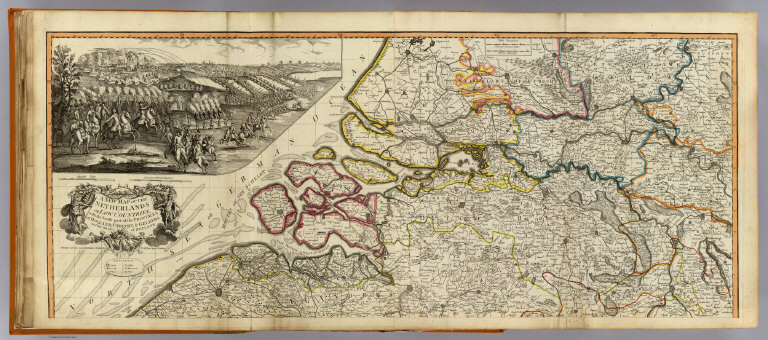
Robert Laurie & James Whittle
Full Title
A new map of the Netherlands or Low Countries, with the south part of the provinces of Holland, Utrecht, & Gelders and the whole of Zeeland. (North half). Published 12th May 1794 by Laurie & Whittle, No. 53 Fleet Street, London.
List No
2310.019
Note
Hand colored engraved map. Relief shown pictorially. Includes illustrated cartouche and 23 x 50 uncolored battle scene. Shows cities, boroughs, villages, castles, monasteries, forts, roads, rivers, etc. Printed on 2 sheets; joined. Prime meridian: Ferro.
Full Title
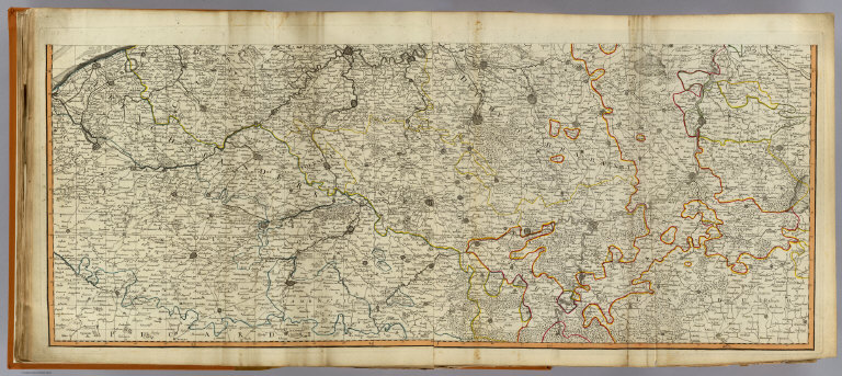
(A new map of the Netherlands or Low Countries, with the south part of the provinces of Holland, Utrecht, & Gelders and the whole of Zeeland. South half. Published 12th May 1794 by Laurie & Whittle, No. 53 Fleet Street, London)
List No
2310.020
Note
Hand colored engraved map. Relief shown pictorially. Shows cities, boroughs, villages, castles, monasteries, forts, roads, rivers, etc. Printed on 2 sheets; joined. Prime meridian: Ferro.
Author
Robert Laurie & James Whittle
Full Title
(Composite of) A new map of the Netherlands or Low Countries, with the south part of the provinces of Holland, Utrecht, & Gelders and the whole of Zeeland. Published 12th May 1794 by Laurie & Whittle, No. 53 Fleet Street, London.
List No
2310.021
Note
Digital composite of 4 hand colored engraved maps, joined as 2 sheets. Relief shown pictorially. Includes illustrated cartouche and 23 x 50 uncolored battle scene. Shows cities, boroughs, villages, castles, monasteries, forts, roads, rivers, etc. Prime meridian: Ferro.
Author
Robert Laurie & James Whittle
Full Title
A new map of the seat of war in the Netherlands, from the best authorities. Published 12th May 1794 by Laurie & Whittle, No. 53 Fleet Street, London.
List No
2310.022
Note
Hand colored engraved map. Shows battle sites with dates, cities, roads, forests, rivers, etc.
Author
Robert Laurie & James Whittle
Full Title
Seat of war in the Seven United Provinces, comprehending Holland, Zeeland, Utrecht, Gelders, Over-Yssel, Frieseland and Groningen; with the land of Drent; also Dutch Flanders and Dutch Brabant. London, Published by Laurie & Whittle, No. 53 Fleet Street, 12th May 1794.
List No
2310.023
Note
Hand colored engraved map. Relief shown pictorially. Shows cities, roads, forests, rivers, etc.
1-8 of 8
|