|
Author
Owen, David Dale
Full Title
Table X. Remains of Archeotherium and Oreodon of the Eocene tertiary of Nebraska. (on opposite page view) Engraved on steel from daguerreotypes of the original specimens by A.B. Walter, Phila(delphia). (to accompany) Illustrations to the Geological Report of Wisconsin, Iowa, and Minnesota. (with) Report of a Geological Survey of Wisconsin, Iowa and Minnesota ... 1852.
List No
0690.024
Note
Descriptive list of the specimens and 6 uncolored views.
Author
Owen, David Dale
Full Title
Table XII. Remains of a species of land turtle, from the Eocene tertiary of Nebraska. (on opposite page view) D.D. Owen. Engraved on steel from daguerreotype of original specimens by J. McGoffin, at J.M. Butler's Establishment. (to accompany) Illustrations to the Geological Report of Wisconsin, Iowa, and Minnesota. (with) Report of a Geological Survey of Wisconsin, Iowa and Minnesota ... 1852.
List No
0690.026
Note
Descriptive list of the specimens and 2 uncolored views.
Author
Owen, David Dale
Full Title
Table XII A. Two species of land turtles, Machairodus, or Sabre-toothed Tiger, and a small species of Rhinoceros from the Eocene Tertiary of Nebraska. (on opposite page view) Engraved on steel from daguerreotype of original specimens. J.M. Butler. (to accompany) Illustrations to the Geological Report of Wisconsin, Iowa, and Minnesota. (with) Report of a Geological Survey of Wisconsin, Iowa and Minnesota ... 1852.
List No
0690.027
Note
Descriptive list of the specimens and 6 uncolored views.
Author
Owen, David Dale
Full Title
Table XII B. Remains of a land turtle, Rhinoceros, and Paleotherium, from the Eocene Tertiary of Nebraska. (on opposite page view) Fig. 1 & 2 engraved on steel from daguerreotype of original specimens. J.M. Butler. (to accompany) Illustrations to the Geological Report of Wisconsin, Iowa, and Minnesota. (with) Report of a Geological Survey of Wisconsin, Iowa and Minnesota ... 1852.
List No
0690.028
Note
Descriptive list of the specimens and 8 uncolored views.
Author
Owen, David Dale
Full Title
Table XIII. Remains of Archaeotherium and Oreodon, from the Eocene Tertiary of Nebraska. Figures are all of the natural size. (on opposite page view) J.M. Butler. (to accompany) Illustrations to the Geological Report of Wisconsin, Iowa, and Minnesota. (with) Report of a Geological Survey of Wisconsin, Iowa and Minnesota ... 1852.
List No
0690.029
Note
Descriptive list of the specimens and 6 uncolored views.
Author
Owen, David Dale
Full Title
Table XIV. Remains of the Rhinoceros, from the Eocene Tertiary of Nebraska. All the figures are reduced one-third. (on opposite page view) J.M. Butler. (to accompany) Illustrations to the Geological Report of Wisconsin, Iowa, and Minnesota. (with) Report of a Geological Survey of Wisconsin, Iowa and Minnesota ... 1852.
List No
0690.030
Note
Descriptive list of the specimens and 3 uncolored views.
Author
Owen, David Dale
Full Title
Table XV. Remains of Eucrotaphus and of the Rhinoceros, from the Eocene Tertiary of Nebraska. All the figures are of natural size. (on opposite page view) Engraved from the original specimens by J.M. Butler. (to accompany) Illustrations to the Geological Report of Wisconsin, Iowa, and Minnesota. (with) Report of a Geological Survey of Wisconsin, Iowa and Minnesota ... 1852.
List No
0690.031
Note
Descriptive list of the specimens and 4 uncolored views.
Author
Owen, David Dale
Full Title
Map showing the positions of the Bad Lands or Mauvaises Terres of Nebraska, from a draft by John Evens of the U.S. Geological Survey. (to accompany) Illustrations to the Geological Report of Wisconsin, Iowa, and Minnesota. (with) Report of a Geological Survey of Wisconsin, Iowa and Minnesota ... 1852.
List No
0690.032
Note
Uncolored map. Shows rivers, forts, mountains. Relief shown by hachures.
Author
[Raynolds,W.F., Maynadier, H.E., Gillespie,G.]
Full Title
War Department Map Of The Yellowstone And Missouri Rivers And Their Tributaries explored by Capt. W.F. Raynolds Topl. Engrs. and 1st Lieut. H.E. Maynadier 10th Infy. Assistant. 1859-60. Revised and Enlarged by Major G.L. Gillespie ... 1876 ... Published by the authority of the Hon. the Secretary Of War Office of the Chief Of Engineers, U.S. Army. 1876. Engraved in the Office of the Chief of Engineers. Western Sheet Map Of Yellowstone And Missouri Rivers ... 1877.
List No
0834.000
Note
Map in 2 sheets; western sheet dated 1877. Highly detailed map, filling in much new information on the original map by Raynolds made in 1859-60 (but published in 1867). This map extends one degree further south than the original map, and for some reason the western sheet does not have the mountains drawn in although the water courses are clearly shown. Unfolded, separately issued on thin paper. Relief shown by hachures.
Author
[Scovel, James L., O'Brien, Emmett J]
Full Title
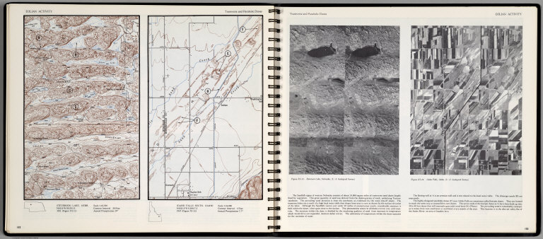
Eolian Activity. Transverse and Parabolic Dunes. Steverson Lake, Nebr. Idaho Falls South, Idaho. Scale 1:24,000. (with aerial view on opposite page) Steverson Lake Nebraska, and Idaho Falls, Idaho.
List No
0889.080
Note
Contour color maps, with location map and text. Relief shown by contours and spot heights.
Author
[Stieler, Adolf, Petermann, A.]
Full Title
Stieler's Hand-Atlas ... No. 82. Petermann: Vereinigte Staaten von Nord-Amerika in 6 Blattern, Bl.2.
List No
0960.101
Author
Thayer, H. L.
Full Title
(Covers to) Thayer's Map of the Black Hills & Big Horn Country. Published By H.L Thayer Denver, Colorado. Carefully prepared from the Official Maps of the General Land Office. Explorations of Capt. Wm. Ludlow and from latest Maps of the routes of General Custer and other Officers of the Army, furnished by Capt. W.S. Stanton Chief Engr. Dept. of the Platte and from the Engineer Dept. at Washington. Entered ... 1877 by H.L. Thayer ... Washington. Edward Rollandet, Draftsman.
List No
0993.001
Note
Rare. One of the earlier Black Hills pocket maps. Wheat: "An imposing production." Border color by state. Map is folded into dark brown cloth covers 15.5x9.5 with purple label reading "Thayer's Map Of The Black Hills And Big Horn Country . One Dollar."
Author
Thayer, H. L.
Full Title
Thayer's Map of the Black Hills & Big Horn Country. Published By H.L Thayer Denver, Colorado. Carefully prepared from the Official Maps of the General Land Office. Explorations of Capt. Wm. Ludlow and from latest Maps of the routes of General Custer and other Officers of the Army, furnished by Capt. W.S. Stanton Chief Engr. Dept. of the Platte and from the Engineer Dept. at Washington. Entered ... 1877 by H.L. Thayer ... Washington. Edward Rollandet, Draftsman.
List No
0993.002
Note
Rare. One of the earlier Black Hills pocket maps. Wheat: "An imposing production." Border color by state. Map is folded into dark brown cloth covers 15.5x9.5 with purple label reading "Thayer's Map Of The Black Hills And Big Horn Country . One Dollar."
Author
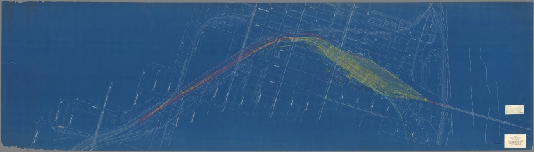
[Atchison and Nebraska Railroad, Chicago, Burlington, and Quincy Railroad]
Full Title
5. A. & N. R.R. (Plans for route of Atchison and Nebraska Railroad)
List No
10287.004
Note
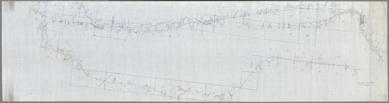
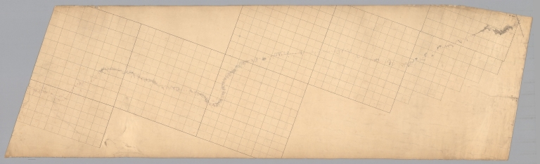
A set of 24 hand-drawn and colored maps showing the route of the proposed Atchison and Nebraska Railroad in northern Kansas and southern Nebraska, just west of the Missouri River. Many annotations in pencil list the land owners of parcels the proposed railroad line goes through and the cost per acre under sale contract. There are also notes on sheet 8 on the Condemnation of land for an owner who will not sell. The line appears to have been built approximately according to the drawings although in some areas the route was changed - this is based on comparing the routes shown on the 1887 county maps. The set of maps provides a detailed record of how land was secured for the railroads and how the lines were surveyed. View in Google Earth https://rumsey3.s3.amazonaws.com/Atchison_and_Nebraska_Railroad_1872.kmz
Author
[Atchison and Nebraska Railroad, Chicago, Burlington, and Quincy Railroad]
Full Title
6. A. & N. R.R. (Plans for route of Atchison and Nebraska Railroad)
List No
10287.005
Note
A set of 24 hand-drawn and colored maps showing the route of the proposed Atchison and Nebraska Railroad in northern Kansas and southern Nebraska, just west of the Missouri River. Many annotations in pencil list the land owners of parcels the proposed railroad line goes through and the cost per acre under sale contract. There are also notes on sheet 8 on the Condemnation of land for an owner who will not sell. The line appears to have been built approximately according to the drawings although in some areas the route was changed - this is based on comparing the routes shown on the 1887 county maps. The set of maps provides a detailed record of how land was secured for the railroads and how the lines were surveyed. View in Google Earth https://rumsey3.s3.amazonaws.com/Atchison_and_Nebraska_Railroad_1872.kmz
Author
[Atchison and Nebraska Railroad, Chicago, Burlington, and Quincy Railroad]
Full Title
7. A. & N. R.R. (Plans for route of Atchison and Nebraska Railroad)
List No
10287.006
Note
A set of 24 hand-drawn and colored maps showing the route of the proposed Atchison and Nebraska Railroad in northern Kansas and southern Nebraska, just west of the Missouri River. Many annotations in pencil list the land owners of parcels the proposed railroad line goes through and the cost per acre under sale contract. There are also notes on sheet 8 on the Condemnation of land for an owner who will not sell. The line appears to have been built approximately according to the drawings although in some areas the route was changed - this is based on comparing the routes shown on the 1887 county maps. The set of maps provides a detailed record of how land was secured for the railroads and how the lines were surveyed. View in Google Earth https://rumsey3.s3.amazonaws.com/Atchison_and_Nebraska_Railroad_1872.kmz
Author
[Atchison and Nebraska Railroad, Chicago, Burlington, and Quincy Railroad]
Full Title
8. A. & N. R.R. (Plans for route of Atchison and Nebraska Railroad)
List No
10287.007
Note
A set of 24 hand-drawn and colored maps showing the route of the proposed Atchison and Nebraska Railroad in northern Kansas and southern Nebraska, just west of the Missouri River. Many annotations in pencil list the land owners of parcels the proposed railroad line goes through and the cost per acre under sale contract. There are also notes on sheet 8 on the Condemnation of land for an owner who will not sell. The line appears to have been built approximately according to the drawings although in some areas the route was changed - this is based on comparing the routes shown on the 1887 county maps. The set of maps provides a detailed record of how land was secured for the railroads and how the lines were surveyed. View in Google Earth https://rumsey3.s3.amazonaws.com/Atchison_and_Nebraska_Railroad_1872.kmz
Author
[Atchison and Nebraska Railroad, Chicago, Burlington, and Quincy Railroad]
Full Title
9. A. & N. R.R. (Plans for route of Atchison and Nebraska Railroad)
List No
10287.008
Note
A set of 24 hand-drawn and colored maps showing the route of the proposed Atchison and Nebraska Railroad in northern Kansas and southern Nebraska, just west of the Missouri River. Many annotations in pencil list the land owners of parcels the proposed railroad line goes through and the cost per acre under sale contract. There are also notes on sheet 8 on the Condemnation of land for an owner who will not sell. The line appears to have been built approximately according to the drawings although in some areas the route was changed - this is based on comparing the routes shown on the 1887 county maps. The set of maps provides a detailed record of how land was secured for the railroads and how the lines were surveyed. View in Google Earth https://rumsey3.s3.amazonaws.com/Atchison_and_Nebraska_Railroad_1872.kmz
Author
[Atchison and Nebraska Railroad, Chicago, Burlington, and Quincy Railroad]
Full Title
10. A. & N. R.R. (Plans for route of Atchison and Nebraska Railroad)
List No
10287.009
Note
A set of 24 hand-drawn and colored maps showing the route of the proposed Atchison and Nebraska Railroad in northern Kansas and southern Nebraska, just west of the Missouri River. Many annotations in pencil list the land owners of parcels the proposed railroad line goes through and the cost per acre under sale contract. There are also notes on sheet 8 on the Condemnation of land for an owner who will not sell. The line appears to have been built approximately according to the drawings although in some areas the route was changed - this is based on comparing the routes shown on the 1887 county maps. The set of maps provides a detailed record of how land was secured for the railroads and how the lines were surveyed. View in Google Earth https://rumsey3.s3.amazonaws.com/Atchison_and_Nebraska_Railroad_1872.kmz
Author
[Atchison and Nebraska Railroad, Chicago, Burlington, and Quincy Railroad]
Full Title
11. A. & N. R.R. (Plans for route of Atchison and Nebraska Railroad)
List No
10287.010
Note
A set of 24 hand-drawn and colored maps showing the route of the proposed Atchison and Nebraska Railroad in northern Kansas and southern Nebraska, just west of the Missouri River. Many annotations in pencil list the land owners of parcels the proposed railroad line goes through and the cost per acre under sale contract. There are also notes on sheet 8 on the Condemnation of land for an owner who will not sell. The line appears to have been built approximately according to the drawings although in some areas the route was changed - this is based on comparing the routes shown on the 1887 county maps. The set of maps provides a detailed record of how land was secured for the railroads and how the lines were surveyed. View in Google Earth https://rumsey3.s3.amazonaws.com/Atchison_and_Nebraska_Railroad_1872.kmz
Author
[Atchison and Nebraska Railroad, Chicago, Burlington, and Quincy Railroad]
Full Title
12. A. & N. R.R. (Plans for route of Atchison and Nebraska Railroad)
List No
10287.011
Note
A set of 24 hand-drawn and colored maps showing the route of the proposed Atchison and Nebraska Railroad in northern Kansas and southern Nebraska, just west of the Missouri River. Many annotations in pencil list the land owners of parcels the proposed railroad line goes through and the cost per acre under sale contract. There are also notes on sheet 8 on the Condemnation of land for an owner who will not sell. The line appears to have been built approximately according to the drawings although in some areas the route was changed - this is based on comparing the routes shown on the 1887 county maps. The set of maps provides a detailed record of how land was secured for the railroads and how the lines were surveyed. View in Google Earth https://rumsey3.s3.amazonaws.com/Atchison_and_Nebraska_Railroad_1872.kmz
Author
[Atchison and Nebraska Railroad, Chicago, Burlington, and Quincy Railroad]
Full Title
13. A. & N. R.R. (Plans for route of Atchison and Nebraska Railroad)
List No
10287.012
Note
A set of 24 hand-drawn and colored maps showing the route of the proposed Atchison and Nebraska Railroad in northern Kansas and southern Nebraska, just west of the Missouri River. Many annotations in pencil list the land owners of parcels the proposed railroad line goes through and the cost per acre under sale contract. There are also notes on sheet 8 on the Condemnation of land for an owner who will not sell. The line appears to have been built approximately according to the drawings although in some areas the route was changed - this is based on comparing the routes shown on the 1887 county maps. The set of maps provides a detailed record of how land was secured for the railroads and how the lines were surveyed. View in Google Earth https://rumsey3.s3.amazonaws.com/Atchison_and_Nebraska_Railroad_1872.kmz
Author
[Atchison and Nebraska Railroad, Chicago, Burlington, and Quincy Railroad]
Full Title
14. A. & N. R.R. (Plans for route of Atchison and Nebraska Railroad)
List No
10287.013
Note
A set of 24 hand-drawn and colored maps showing the route of the proposed Atchison and Nebraska Railroad in northern Kansas and southern Nebraska, just west of the Missouri River. Many annotations in pencil list the land owners of parcels the proposed railroad line goes through and the cost per acre under sale contract. There are also notes on sheet 8 on the Condemnation of land for an owner who will not sell. The line appears to have been built approximately according to the drawings although in some areas the route was changed - this is based on comparing the routes shown on the 1887 county maps. The set of maps provides a detailed record of how land was secured for the railroads and how the lines were surveyed. View in Google Earth https://rumsey3.s3.amazonaws.com/Atchison_and_Nebraska_Railroad_1872.kmz
Author
[Atchison and Nebraska Railroad, Chicago, Burlington, and Quincy Railroad]
Full Title
15. A. & N. R.R. (Plans for route of Atchison and Nebraska Railroad)
List No
10287.014
Note
A set of 24 hand-drawn and colored maps showing the route of the proposed Atchison and Nebraska Railroad in northern Kansas and southern Nebraska, just west of the Missouri River. Many annotations in pencil list the land owners of parcels the proposed railroad line goes through and the cost per acre under sale contract. There are also notes on sheet 8 on the Condemnation of land for an owner who will not sell. The line appears to have been built approximately according to the drawings although in some areas the route was changed - this is based on comparing the routes shown on the 1887 county maps. The set of maps provides a detailed record of how land was secured for the railroads and how the lines were surveyed. View in Google Earth https://rumsey3.s3.amazonaws.com/Atchison_and_Nebraska_Railroad_1872.kmz
Author
[Atchison and Nebraska Railroad, Chicago, Burlington, and Quincy Railroad]
Full Title
16. A. & N. R.R. (Plans for route of Atchison and Nebraska Railroad)
List No
10287.015
Note
A set of 24 hand-drawn and colored maps showing the route of the proposed Atchison and Nebraska Railroad in northern Kansas and southern Nebraska, just west of the Missouri River. Many annotations in pencil list the land owners of parcels the proposed railroad line goes through and the cost per acre under sale contract. There are also notes on sheet 8 on the Condemnation of land for an owner who will not sell. The line appears to have been built approximately according to the drawings although in some areas the route was changed - this is based on comparing the routes shown on the 1887 county maps. The set of maps provides a detailed record of how land was secured for the railroads and how the lines were surveyed. View in Google Earth https://rumsey3.s3.amazonaws.com/Atchison_and_Nebraska_Railroad_1872.kmz
Author
[Atchison and Nebraska Railroad, Chicago, Burlington, and Quincy Railroad]
Full Title
17. A. & N. R.R. (Plans for route of Atchison and Nebraska Railroad)
List No
10287.016
Note
A set of 24 hand-drawn and colored maps showing the route of the proposed Atchison and Nebraska Railroad in northern Kansas and southern Nebraska, just west of the Missouri River. Many annotations in pencil list the land owners of parcels the proposed railroad line goes through and the cost per acre under sale contract. There are also notes on sheet 8 on the Condemnation of land for an owner who will not sell. The line appears to have been built approximately according to the drawings although in some areas the route was changed - this is based on comparing the routes shown on the 1887 county maps. The set of maps provides a detailed record of how land was secured for the railroads and how the lines were surveyed. View in Google Earth https://rumsey3.s3.amazonaws.com/Atchison_and_Nebraska_Railroad_1872.kmz
Author
[Atchison and Nebraska Railroad, Chicago, Burlington, and Quincy Railroad]
Full Title
18. A. & N. R.R. (Plans for route of Atchison and Nebraska Railroad)
List No
10287.017
Note
A set of 24 hand-drawn and colored maps showing the route of the proposed Atchison and Nebraska Railroad in northern Kansas and southern Nebraska, just west of the Missouri River. Many annotations in pencil list the land owners of parcels the proposed railroad line goes through and the cost per acre under sale contract. There are also notes on sheet 8 on the Condemnation of land for an owner who will not sell. The line appears to have been built approximately according to the drawings although in some areas the route was changed - this is based on comparing the routes shown on the 1887 county maps. The set of maps provides a detailed record of how land was secured for the railroads and how the lines were surveyed. View in Google Earth https://rumsey3.s3.amazonaws.com/Atchison_and_Nebraska_Railroad_1872.kmz
Author
[Atchison and Nebraska Railroad, Chicago, Burlington, and Quincy Railroad]
Full Title
19. A. & N. R.R. (Plans for route of Atchison and Nebraska Railroad)
List No
10287.018
Note
A set of 24 hand-drawn and colored maps showing the route of the proposed Atchison and Nebraska Railroad in northern Kansas and southern Nebraska, just west of the Missouri River. Many annotations in pencil list the land owners of parcels the proposed railroad line goes through and the cost per acre under sale contract. There are also notes on sheet 8 on the Condemnation of land for an owner who will not sell. The line appears to have been built approximately according to the drawings although in some areas the route was changed - this is based on comparing the routes shown on the 1887 county maps. The set of maps provides a detailed record of how land was secured for the railroads and how the lines were surveyed. View in Google Earth https://rumsey3.s3.amazonaws.com/Atchison_and_Nebraska_Railroad_1872.kmz
Author
[Atchison and Nebraska Railroad, Chicago, Burlington, and Quincy Railroad]
Full Title
20. A. & N. R.R. (Plans for route of Atchison and Nebraska Railroad)
List No
10287.019
Note
A set of 24 hand-drawn and colored maps showing the route of the proposed Atchison and Nebraska Railroad in northern Kansas and southern Nebraska, just west of the Missouri River. Many annotations in pencil list the land owners of parcels the proposed railroad line goes through and the cost per acre under sale contract. There are also notes on sheet 8 on the Condemnation of land for an owner who will not sell. The line appears to have been built approximately according to the drawings although in some areas the route was changed - this is based on comparing the routes shown on the 1887 county maps. The set of maps provides a detailed record of how land was secured for the railroads and how the lines were surveyed. View in Google Earth https://rumsey3.s3.amazonaws.com/Atchison_and_Nebraska_Railroad_1872.kmz
Author
[Atchison and Nebraska Railroad, Chicago, Burlington, and Quincy Railroad]
Full Title
21. A. & N. R.R. (Plans for route of Atchison and Nebraska Railroad)
List No
10287.020
Note
A set of 24 hand-drawn and colored maps showing the route of the proposed Atchison and Nebraska Railroad in northern Kansas and southern Nebraska, just west of the Missouri River. Many annotations in pencil list the land owners of parcels the proposed railroad line goes through and the cost per acre under sale contract. There are also notes on sheet 8 on the Condemnation of land for an owner who will not sell. The line appears to have been built approximately according to the drawings although in some areas the route was changed - this is based on comparing the routes shown on the 1887 county maps. The set of maps provides a detailed record of how land was secured for the railroads and how the lines were surveyed. View in Google Earth https://rumsey3.s3.amazonaws.com/Atchison_and_Nebraska_Railroad_1872.kmz
Author
[Atchison and Nebraska Railroad, Chicago, Burlington, and Quincy Railroad]
Full Title
21a. A. & N. R.R. (Plans for route of Atchison and Nebraska Railroad)
List No
10287.021
Note
A set of 24 hand-drawn and colored maps showing the route of the proposed Atchison and Nebraska Railroad in northern Kansas and southern Nebraska, just west of the Missouri River. Many annotations in pencil list the land owners of parcels the proposed railroad line goes through and the cost per acre under sale contract. There are also notes on sheet 8 on the Condemnation of land for an owner who will not sell. The line appears to have been built approximately according to the drawings although in some areas the route was changed - this is based on comparing the routes shown on the 1887 county maps. The set of maps provides a detailed record of how land was secured for the railroads and how the lines were surveyed. View in Google Earth https://rumsey3.s3.amazonaws.com/Atchison_and_Nebraska_Railroad_1872.kmz
Author
[Atchison and Nebraska Railroad, Chicago, Burlington, and Quincy Railroad]
Full Title
27. A. & N. R.R. (Plans for route of Atchison and Nebraska Railroad)
List No
10287.022
Note
A set of 24 hand-drawn and colored maps showing the route of the proposed Atchison and Nebraska Railroad in northern Kansas and southern Nebraska, just west of the Missouri River. Many annotations in pencil list the land owners of parcels the proposed railroad line goes through and the cost per acre under sale contract. There are also notes on sheet 8 on the Condemnation of land for an owner who will not sell. The line appears to have been built approximately according to the drawings although in some areas the route was changed - this is based on comparing the routes shown on the 1887 county maps. The set of maps provides a detailed record of how land was secured for the railroads and how the lines were surveyed. View in Google Earth https://rumsey3.s3.amazonaws.com/Atchison_and_Nebraska_Railroad_1872.kmz
Author
[Atchison and Nebraska Railroad, Chicago, Burlington, and Quincy Railroad]
Full Title
28. A. & N. R.R. (Plans for route of Atchison and Nebraska Railroad)
List No
10287.023
Note
A set of 24 hand-drawn and colored maps showing the route of the proposed Atchison and Nebraska Railroad in northern Kansas and southern Nebraska, just west of the Missouri River. Many annotations in pencil list the land owners of parcels the proposed railroad line goes through and the cost per acre under sale contract. There are also notes on sheet 8 on the Condemnation of land for an owner who will not sell. The line appears to have been built approximately according to the drawings although in some areas the route was changed - this is based on comparing the routes shown on the 1887 county maps. The set of maps provides a detailed record of how land was secured for the railroads and how the lines were surveyed. View in Google Earth https://rumsey3.s3.amazonaws.com/Atchison_and_Nebraska_Railroad_1872.kmz
Author
[Atchison and Nebraska Railroad, Chicago, Burlington, and Quincy Railroad]
Full Title
29. A. & N. R.R. (Plans for route of Atchison and Nebraska Railroad)
List No
10287.024
Note
A set of 24 hand-drawn and colored maps showing the route of the proposed Atchison and Nebraska Railroad in northern Kansas and southern Nebraska, just west of the Missouri River. Many annotations in pencil list the land owners of parcels the proposed railroad line goes through and the cost per acre under sale contract. There are also notes on sheet 8 on the Condemnation of land for an owner who will not sell. The line appears to have been built approximately according to the drawings although in some areas the route was changed - this is based on comparing the routes shown on the 1887 county maps. The set of maps provides a detailed record of how land was secured for the railroads and how the lines were surveyed. View in Google Earth https://rumsey3.s3.amazonaws.com/Atchison_and_Nebraska_Railroad_1872.kmz
Author
[Chicago, Burlington, and Quincy Railroad, Atchison and Nebraska Railroad]
Full Title
Nemaha City to Falls City. Lines Run 1880, 1881, 1882, 1883. Rant. Koon. Sanke. Billings. Ensign.
List No
10289.000
Note
Title on verso of map.
Author
Chicago, Burlington, and Quincy Railroad
Full Title
Map of Locations West of Blue Hill To Franklin County. 1885 & 1886.
List No
10291.000
Author
Chicago, Burlington, and Quincy Railroad
Full Title
(Plan for a Rail Line Running West from DeWitt Nebraska)
List No
10296.000
Note
Date estimated.
Author
Chicago, Burlington, and Quincy Railroad
Full Title
Plan of C.C. Knowles' Pre.iminary Lines 1871. June 24th 1872
List No
10297.000
Author
Union Pacific Railroad
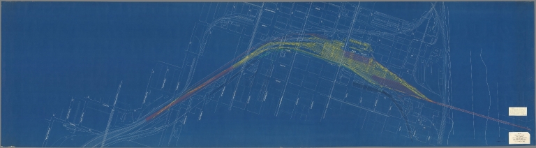
Full Title
Plan "B" Omaha Union Station Proposed Rearrangement of Facilities.
List No
10298.002
Author
Union Pacific Railroad
Full Title
Plan "C" Omaha Union Station Proposed Rearrangement of Facilities.
List No
10298.003
Author
U.S. General Land Office
Full Title
(12) Map Showing the progress of the Public surveys in Kansas and Nebraska. 1866. Surveyor General's Office, Leavenworth, Kansas, August 25th, 1866. Department of the Interior, General Land Office, October 2nd 1866. Jo. S. Wilson, Commissioner. No. 15. Bowen & Co. lith. Philada.
List No
1070.015
Note
In outline color with the land offices in pink and the surveyor general's office in green. The legend includes coal, lead, platina, marble, and salt lands.
Author
U.S. General Land Office
Full Title
(Map 11 - Wyoming, Nebraska, Colorado, Kansas, South Dakota).
List No
1071.013
Note
One of the series of adjacent sixteen maps. Mounted on linen. Relief shown in hachures.
Author
U.S. General Land Office
Full Title
Department of the Interior, General Land Office. S.S. Burdett, Commissioner. State of Nebraska. 1876. Compiled from the official records of the General Land Office and other sources by C. Roeser, Principal Draughtsman G.L.O. Photolith. & Print by Julius Bien 16 & 18 Park Place, N.Y.
List No
11179.009
Note
Color map. Includes references. Relief shown by hachures. Prime meridians are Greenwich and Washington.
Author
Larrance, Isaac, 1804-1896
Full Title
Nebraska Counties. (to accompany) Larrance's Post office chart, and maps of ten states ... By Isaac Larrance. Cincinnati : Printed and for sale by I. A. Pittman. 1866.
List No
11666.042
Note
Map of Nebraska Counties, printed in red with decorative blue borders. Shows county boundaries and major roads.
Author
Larrance, Isaac, 1804-1896
Full Title
County Seats in Nebraska. (to accompany) Larrance's Post office chart, and maps of ten states ... By Isaac Larrance. Cincinnati : Printed and for sale by I. A. Pittman. 1866.
List No
11666.044
Note
Map of County Seats in Nebraska, printed in red with decorative blue borders. Shows county boundaries and major roads.
Author
Larrance, Isaac, 1804-1896
Full Title
(Text Page to) An easy way to calculate interest ... (to accompany) Larrance's Post office chart, and maps of ten states ... By Isaac Larrance. Cincinnati : Printed and for sale by I. A. Pittman. 1866.
List No
11666.045
Note
Advertisement in two pages.
Author
Warren, Gouverneur Kemble, 1830-1882
Full Title
(Title Page to) Explorations in the Dacota Country, in the Year 1855. By Lieut. G.K. Warren, Topographical Engineer of the "Sioux Expedition." Senate. 34th Congress, 1st Session. Ex. Doc. No. 76. Washington: A.O.P. Nicholson, Senate Printer. 1856. (with map) Reconnoissances in the Dacota Country By G.K. Warren, Lieut: Topl. Engrs. U.S.A. ... P.S. Duval & Co. Lith. Philada. (profile) Profile Of Route From Fort Pierre To Fort Kearney ... 1855.
List No
1172A
Author
Warren, Gouverneur Kemble, 1830-1882
Full Title
Reconnoissances in the Dacota Country By G.K. Warren, Lieut: Topl. Engrs. U.S.A. ... P.S. Duval & Co. Lith. Philada. (profile) Profile Of Route From Fort Pierre To Fort Kearney ... 1855.
List No
1172.001
Note
The large map, 92x153, "Reconnoissances in the Dacota Country", is one of the most detailed, large scale maps of eastern Nebraska of the period. Map is without color. Bound with new cloth covered boards, "Explorations in the Dacota Country, G.K. Warren, 1856" on spine.
Author
[Warren, G.K., U. S. Army. Corps of Engineers]
Full Title
Map Of Nebraska And Dakota, And Portions Of The States And Territories Bordering Thereon, Compiled By Bv't Maj. Gen. G.K. Warren, Maj. Engineers. March, 1867 ... Engineer Dep't U.S. Army. Bv't Maj. Gen. A.A. Humphreys, Chief Of Engineers.
List No
1173.000
Note
Later version of 1858 edition. Includes routes, surveys and reconnaissances indexed by dates and name of person in charge. Not in Wheat. Unfolded separate issue. In two sheets; without color. Relief shown by hachures.
Author
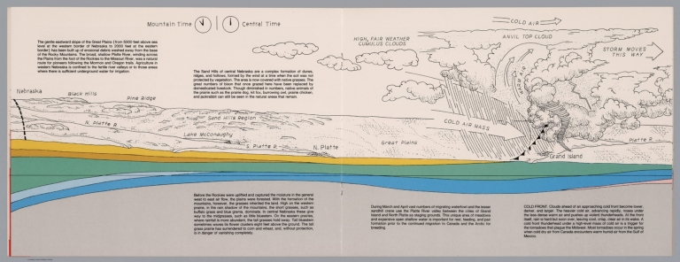
Raymo, Chet
Full Title
(Great Plains, Nebraska). (to accompany) A geologic and topographic profile of the United States along interstate 80 : by Chet Raymo. 1982. Printed by Hubbard, Northbrook, IL.
List No
13323.009
Note
Geologic cross section and topographic map of Great Plains, Nebraska. Showing weather system, dunes, ridges and vegetation. Relief shown pictorially. Includes time zone clocks, showing Mountain standard time and Central standard time. Includes descriptive text.
|