|
Author
United States. Post Office Department
Full Title
Post Route Map of the States of Montana, Idaho, and Wyoming. Frank H. Hitchcock... David M. Hildreth.
List No
15912.002
Author
United States. Post Office Department
Full Title
(Composite map to) Post Route Map of the States of Montana, Idaho, and Wyoming. Frank H. Hitchcock... David M. Hildreth.
List No
15912.003
Author
Cram, George Franklin, 1841-1928
Full Title
Montana. 1899, by Geo. F. Cram.
List No
14372.211
Note
Map of Montana. Shows political boundaries, counties, towns, railroads, topography, bodies of water, drainage, coastlines and islands. Relief shown with hachures. Includes key with explanation, latitudinal and longitudinal lines, as well as a bar scale given in miles. With alphanumeric grid corresponding to "Index of Montana" on pages 387 and 390. Colored lithograph. Map is 40 x 56 cm, on double sheet 45 x 67 cm. "Index of maps" and "Index of cities" in margins, providing navigation for atlas as a whole.
Author
Hornaday, William T.
Full Title
Sketch Map of the Hunt for Buffalo. Montana, 1886.
List No
15536.004
Note
For the full text of this book see https://archive.org/details/exterminationofa00horn/page/n5/mode/2up
Author
[Shope, Irvin, Fletcher, Bob]
Full Title
[Hittin' the high spots in Montana].
List No
14466.002
Note
Pictorial map of Montana. Appears as a montage of photographic imagery featuring representative sites, animals and vegetation for the state. Margins filled with silhouette images of horse-drawn wagons and indigenous people. With decorative border. Map printed in black and white. Map is 43 x 56 cm, on sheet 44 x 57 cm.
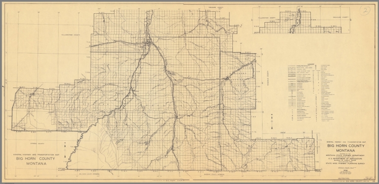
Author
Montana. State Highway Commission.
Full Title
General Highway and Transportation Map Big Horn County Montana sheet 1
List No
15298.003
Note
Dimensions are for full sheets.
Author
Montana. State Highway Commission.
Full Title
General Highway and Transportation Map Big Horn County Montana sheet 2
List No
15298.004
Note
Dimensions are for full sheets.
Author
Montana. State Highway Commission.
Full Title
(Composite map of) General Highway and Transportation Map Big Horn County Montana sheets 1-2
List No
15298.049
Note
Dimensions are for full sheets.
Author
Montana. State Highway Commission.
Full Title
General Highway and Transportation Map Carter County Montana sheet 2
List No
15298.005
Note
Dimensions are for full sheets.
Author
Montana. State Highway Commission.
Full Title
General Highway and Transportation Map Carter County Montana sheet 1
List No
15298.006
Note
Dimensions are for full sheets.
Author
Montana. State Highway Commission.
Full Title
(Composite map of) General Highway and Transportation Map Carter County Montana sheets 1-2
List No
15298.050
Note
Dimensions are for full sheets.
Author
Montana. State Highway Commission.
Full Title
General Highway and Transportation Map Custer County Montana sheet 1
List No
15298.007
Note
Dimensions are for full sheets.
Author
Montana. State Highway Commission.
Full Title
General Highway and Transportation Map Custer County Montana sheet 2
List No
15298.008
Note
Dimensions are for full sheets.
Author
Montana. State Highway Commission.
Full Title
(Composite map of) General Highway and Transportation Map Custer County Montana sheets 1- 2
List No
15298.051
Note
Dimensions are for full sheets.
Author
Montana. State Highway Commission.
Full Title
General Highway and Transportation Map Daniels County Montana
List No
15298.009
Note
Dimensions are for full sheets.
Author
Montana. State Highway Commission.
Full Title
General Highway and Transportation Map Dawson County Montana
List No
15298.010
Note
Dimensions are for full sheets.
Author
[3, Soviet Union. Glavnoe upravlenie geodezii i kartografii]
Full Title
Запад США = Zapad SShA. 242-243. Atlas Mira : 1954.
List No
13682.256
Note
Physical map of the West of the United States. Showing state boundaries. Relief shown by shadings, contours and spot heights. Depths shown by gradient tints, isolines and soundings.
Author
Great Northern Railway
Full Title
Glacier National Park aeroplane map.
List No
15236.001
Note
Date estimated.
Author
Great Northern Railway
Full Title
Glacier National Park aeroplane map.
List No
15236.002
Note
Date estimated.
Author
Great Northern Railway
Full Title
Glacier National Park aeroplane map.
List No
15236.003
Note
Date estimated.
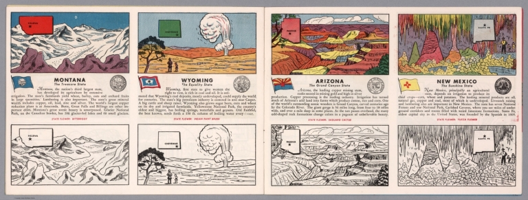
Author
[Fisher, Joseph R., Planters Peanuts (Firm)]
Full Title
Montana : The treasure state -- Wyoming : The equality state -- Arizona : The Grand Canyon state -- New Mexico : The sunshine state.
List No
14374.014
Note
Four views, representing Montana, Wyoming, Arizona and New Mexico. Views show examples of the landscape and natural resources. Each view includes an inset map of the state, which marks the location of the capital city with a star. Accompanied by descriptive text, the state flags, seals and flowers: bitterroot, Indian paint brush, saguaro cactus and yucca flower, respectively. The view of each state appears both in color (on top) and in black and white (bottom), the latter inviting coloration. Together, views are 18 x 52 cm, on two sheets 20 x 54 cm.
Author
[(Montana) Railroad Commission, Rand McNally and Company.]
Full Title
Railroad Commission Map Of Montana 1908. Commissioners: B.T. Stanton, Nathan Godfrey, E.A. Morley, H.K. Howry, Secretary. Rand, McNally & Co. Engravers, Chicago. Copyright, 1908, by Rand McNally & Co.
List No
4343.002
Author
Shane, Ralph M.
Full Title
Early history, Blackfeet Indian Reservation, Montana. Compiled and drawn by Ralph M. Shane. 1966.
List No
13654.000
Author
Shane, Ralph M.
Full Title
Historical map of the Crow Indian Reservation : home of the Crows or Absarokee "children of the large beaked bird". Ralph M. Shane.
List No
13655.000
Author
Shane, Ralph M.
Full Title
Historical map of the Fort Belknap Indian Reservation : Gros Ventres & Assiniboines. Compiled and drawn by Ralph M. Shane. 1974
List No
13656.000
Author
Shane, Ralph M.
Full Title
History of the Indian tribes of Montana. Compiled and drawn by Ralph M. Shane. 1974
List No
13657.000
Author
Shane, Ralph M.
Full Title
Recreation and historical map, Fort Peck Reservation : home of the Assiniboine and Sioux. Drawn by Ralph M. Shane. 1978.
List No
13658.000
Author
Shane, Ralph M.
Full Title
Early history of the Northern Cheyennes, the Morning Star people. The Northern Cheyenne Indian Reservation Agency Headquarters: Lame Deer, Montana. Compiled and drawn by Ralph M. Shane. 1966.
List No
13659.000
Author
Shane, Ralph M.
Full Title
Historical map of the Rocky Boy's Reservation, Montana : home of the Chippewa-Cree, Montana. Compiled and drawn by Ralph M. Shane.
List No
13660.000
Author
Shane, Ralph M.
Full Title
Historical map, confederated Salish and Kootenai tribes of the Flathead Reservation, Montana. Compiled and drawn by Ralph M. Shane. 1974.
List No
13662.000
Author
Union Pacific Railway Company.
Full Title
World's pictorial line : birdseye view of the great Salt Lake Basin reached via the Union Pacific, the overland route. Knight, Leonard & Co., Printers and engravers, Chicago, Ill. Copyrighted. 1893, by E.L. Lomax, General passenger and ticket agent, Union Pacific System, Omaha, Neb.
List No
13206.003
Note
Color pictorial map, on sheet 114 x 45, folded to 23 x 10. Title from cover, with 28 pages of text. On verso 24 pages of text "Sights and scenes in Idaho and Montana", on recto text pages 25-28. Includes logo of "Union Pacific, the overland route" on cover. Map shows major cities, routes, rivers and mountains. Relief shown pictorially.
Author
Great Falls Townsite Company
Full Title
Great Falls, Montana. Size of lots, 50x150.
List No
13131.000
Note
Map of the Townsite of Great Falls, Montana. published by its original founders (Great Falls Townsite Company) in December 1883. The map illustrates the newly platted town site for Great Falls, in the Fall or Winter of 1883-84, during the first few months of its existence. Includes views of Great Falls and Black Eagle Falls at the top of the map, intended to promote the prospect of creating water powered industry at the new town site. Great Falls was created in 1883 by Paris Gibson. On June 3, 1883, an announcement of acquisition of land by what would become the Great Falls Townsite Company appeared in The River Press (Fort Benton, M.T.). By June 27, 1883, the planned city was announced in a two column article in The River Press and the Butte Miner with the headline "Great Falls -- The Coming Minneapolis of Montana," extolling the virtues of the water power at the site. By the Spring of 1884, the first construction had begun.
Author
Amerine, C.H.
Full Title
C.H. Amerine's : Sectional map of Washington, Oregon, Idaho, and western Montana. Compiled from latest official data exploration and other sources. Compiled and published by C.H. Amerine, 1891. Copyrighted by C.H. Amerine, Tacoma, Wash. Photo - Litho by Schmidt Lable & Lith Co. S.F.
List No
6744.000
Note
Amerine published several maps of Washington, Oregon, Puget Sound and other areas of the Pacific Northwest, but this is his only multi-state map that we know of and it is not held in any libraries listed in WorldCat. Full color map, backed with linen. Shows capitals, county, towns, wagon roads, railroads, trails, reservations, light houses, blocks, subdivisions, etc. Includes explanation and table of township subdivision. Relief shown by hachures. Prime meridian is Washington.
Author
Appleton, D. & Co.
Full Title
Map of Montana, Idaho and Wyoming. Copyright 1891 by Matthews-Northrup Co. ... Buffalo, New York. (to accompany) The Library Atlas Of Modern Geography ... New York, D. Appleton And Company 1892. (on upper margin)
List No
0026.205
Note
Color map. Shows state and county boundaries and county seat, capital, railways, roads, etc. "Size of type indicates importance of the places". Includes notes. Relief shown by hachures. Prime meridians are Greenwich and Washington.
Author
Appleton, D. & Co.
Full Title
Map of St. Louis, Mo. Copyright 1891 by Matthews-Northrup Co. ... Buffalo, New York. (to accompany) The Library Atlas Of Modern Geography ... New York, D. Appleton And Company 1892. (on upper margin) St. Louis. 81.
List No
0026.210
Note
Color plan of Saint Louis. Shows railways, street car lines, city blocks, parks, etc. Includes list of Union Depot, and numerical references to hotels, churches, major buildings, and points of interest.
Author
Arbuckle Bros.
Full Title
Colorado, Utah, Montana, Minnesota. Copyright 1889 Arbuckle Bros. N.Y.
List No
0027.007
Note
Sheet with maps of four states in full color. The Colorado plains are known as a "paradise for invalids" due to the mildness and purity of the atmosphere. Each card measures 7.5 x 12.5 cm.
Author
Asher & Adams
Full Title
Asher & Adams' Montana eastern portion. Entered according to Act of Congress in the year 1874 by Asher & Adams ... at Washington. (New York, 1874)
List No
0041.036
Note
Hand col. engraved map. Relief shown by hachures and spot heights. Shows townships, etc. Prime meridians: Greenwich and Washington.
Author
Asher & Adams
Full Title
Asher & Adams' Idaho, Montana western portion. Entered according to Act of Congress in the year 1874 by Asher & Adams ... at Washington. (New York, 1874)
List No
0041.037
Note
Hand col. engraved map. Relief shown by hachures. Shows townships, etc. Prime meridians: Greenwich and Washington.
Author
Asher & Adams
Full Title
(Composite of) Asher & Adams' Montana eastern portion. Entered according to Act of Congress in the year 1874 by Asher & Adams ... at Washington. (New York, 1874)
List No
0041.038
Note
Composite of 2 maps. Hand col. engraved map. Relief shown by hachures and spot heights. Shows townships, etc. Prime meridians: Greenwich and Washington.
Author
Colton, G.W.
Full Title
Colton's Map of Oregon, Washington, Idaho, British Columbia & Montana. Published By J. H. Colton. No. 172 William St. New York.
List No
0151.063
Note
Map showing the state boundaries in color, including portion of California, Nevada, Dakota and Utah. Prime meridians are Greenwich and Washington D.C. Relief shown by hachures.
Author
Colton, G.W.
Full Title
Colton's Oregon, Washington, Idaho, Montana and British Columbia. Published By G. W & C. B. Colton & Co. No. 172 William St. New York.
List No
0152.065
Note
Prime meridians are Washington D.C. and Greenwich.
Author
Cram, George Franklin
Full Title
Montana.
List No
0210.049
Note
Prime meridians Greenwich and Washington.
Author
Gray, O.W.
Full Title
Gray's Atlas Map of Idaho, Montana and Wyoming.
List No
0310.078
Author
[Gray, Frank A., Gray, O.W.]
Full Title
Gray's Idaho, Montana and Wyoming.
List No
0312.049
Author
Johnson, A.J.
Full Title
Johnson's Nebraska, Dakota, Idaho, Montana and Wyoming. Entered ... 1865.
List No
0358.047
Author
Leahy, J.F.
Full Title
(Index to) Leahy's Hotel Guide and Railway Distance Maps. Montana.
List No
0425.072
Note
Alphabetical index list of the Hotels of the town with the number of rooms of each, their rates per day and the population of the town. Includes population of the states, Explanation of abbreviation of the railroad of the state, and advertisements.
Author
Leahy, J.F.
Full Title
Leahy's Hotel Guide and Railway Distance Map of the State of Montana. Published by American Hotel Register Company. Leahy Build., 228-234 W. Ontario St., Chicago, Ill. Copyrighted by J.F. Leahy, Jan., 1934.
List No
0425.073
Note
Map printed without color. Includes name of the railroad entering the town, and distance between towns. Showing location of Yellowstone National Park.
Author
Ludlow, William
Full Title
(Covers to) Report of a Reconnaissance From Carroll, Montana Territory, on the Upper Missouri, to the Yellowstone National Park, and Return Made in the Summer of 1875, by William Ludlow ... Washington: Government Printing Office. 1876.
List No
0446.001
Note
Early maps of Yellowstone; Wheat 1257,1258,1259. 155 pages, illustrations, plates , and 3 folded uncolored maps. Bound with blue cloth covered boards with title on spine in gold "Carroll Montana to Yellowstone National Park; Ludlow 1875." Contents includes: General report, by W. Ludlow.--Trip to the Judith basin; trip form Carroll to Ellis, by R. E. Thompson.--Zoological report, by G. B. Grinnell.--Geological report, by E. S. Dana and G. B. Grinnell.--Description of new fossils, by R. P. Whitfield.
Author
Ludlow, William
Full Title
(Title Page to) Report of a Reconnaissance From Carroll, Montana Territory, on the Upper Missouri, to the Yellowstone National Park, and Return Made in the Summer of 1875, by William Ludlow ... Washington: Government Printing Office. 1876.
List No
0446.002
Note
Early maps of Yellowstone; Wheat 1257,1258,1259. 155 pages, illustrations, plates , and 3 folded uncolored maps. Bound with blue cloth covered boards with title on spine in gold "Carroll Montana to Yellowstone National Park; Ludlow 1875." Contents includes: General report, by W. Ludlow.--Trip to the Judith basin; trip form Carroll to Ellis, by R. E. Thompson.--Zoological report, by G. B. Grinnell.--Geological report, by E. S. Dana and G. B. Grinnell.--Description of new fossils, by R. P. Whitfield.
Author
Ludlow, William
Full Title
(Contents to) Contents. (to accompany) Report of a Reconnaissance From Carroll, Montana Territory, on the Upper Missouri, to the Yellowstone National Park, and Return Made in the Summer of 1875, by William Ludlow ... Washington: Government Printing Office. 1876.
List No
0446.003
Note
Early maps of Yellowstone; Wheat 1257,1258,1259. 155 pages, illustrations, plates , and 3 folded uncolored maps. Bound with blue cloth covered boards with title on spine in gold "Carroll Montana to Yellowstone National Park; Ludlow 1875." Contents includes: General report, by W. Ludlow.--Trip to the Judith basin; trip form Carroll to Ellis, by R. E. Thompson.--Zoological report, by G. B. Grinnell.--Geological report, by E. S. Dana and G. B. Grinnell.--Description of new fossils, by R. P. Whitfield.
Author
Ludlow, William
Full Title
Judith Basin : drawn under the direction of Capt. W. Ludlow Corps of Engineers, to accompany his report. N. Peters, Photo Lithographer, Washington, D.C. (to accompany) Report of a Reconnaissance From Carroll, Montana Territory, on the Upper Missouri, to the Yellowstone National Park, and Return Made in the Summer of 1875, by William Ludlow ... Washington: Government Printing Office. 1876.
List No
0446.004
Note
Relief shown by form lines. Shows exploration routes and dates.
Author
Ludlow, William
Full Title
Upper Geyser Basin : drawn under the direction of Capt. W. Ludlow Corps of Engineers, to accompany his report. Complied and drawn by Ch. Becker, Sergt. U.S.E. N. Peters, Photo Lithographer, Washington, D.C. (to accompany) Report of a Reconnaissance From Carroll, Montana Territory, on the Upper Missouri, to the Yellowstone National Park, and Return Made in the Summer of 1875, by William Ludlow ... Washington: Government Printing Office. 1876.
List No
0446.005
Note
Relief shown by hachures and form lines.
Author
Ludlow, William
Full Title
New species of fossils. Capt. Wm. Ludlow's exp. to Yellowstone Park, 1875. Plate. 1. H.M. Martin, del. T. Sinclair & Son, lith. Phila. (to accompany) Report of a Reconnaissance From Carroll, Montana Territory, on the Upper Missouri, to the Yellowstone National Park, and Return Made in the Summer of 1875, by William Ludlow ... Washington: Government Printing Office. 1876.
List No
0446.006
Note
Uncolored view of new species of fosils.
Author
Ludlow, William
Full Title
New species of fossils. Capt. Wm. Ludlow's exp. to Yellowstone Park, 1875. Plate. 2. H.M. Martin, del. T. Sinclair & Son, lith. Phila. (to accompany) Report of a Reconnaissance From Carroll, Montana Territory, on the Upper Missouri, to the Yellowstone National Park, and Return Made in the Summer of 1875, by William Ludlow ... Washington: Government Printing Office. 1876.
List No
0446.007
Note
Uncolored view of new species of fosils.
Author
Ludlow, William
Full Title
Map of a Reconnaissance From Carroll, Montana Ter. to the Yellowstone National Park, and Return, by Captain William Ludlow Corps of Engineers. Chief Engineer Dept. of Dakota. In July August, and September 1875. Published by ... Office of the Chief o Engineers, U.S. Army. Compiled and drawn by ... W.H. Wood. N. Peters, Photo Lithographer, Washington, D.C. (to accompany) Report of a Reconnaissance From Carroll, Montana Territory, on the Upper Missouri, to the Yellowstone National Park, and Return Made in the Summer of 1875, by William Ludlow ... Washington: Government Printing Office. 1876.
List No
0446.008
Note
Uncolored map. Shows drainage, trails, etc. Relief shown by formlines. Includes list of authorities.
Author
Johnson, A.J.
Full Title
Johnson's Nebraska, Dakota, Idaho, and Montana Published By Johnson And Ward.
List No
0535.039
Note
Relief shown by hachures. Meridians Greenwich and Washington D.C.
Author
Mitchell, Samuel Augustus Jr.
Full Title
Map of Oregon, Washington, Idaho, and Part of Montana. Entered ... 1860 by S. Augustus Mitchell, Jr. ... Pennsylvania.
List No
0572.039
Note
Full color map by county. Relief shown by hachures. Prime meridians are Greenwich and Washington, D.C.
Author
Mitchell, Samuel Augustus Jr.
Full Title
Map of Oregon, Washington, Idaho, and part of Montana. Entered ... 1867 by S. Augustus Mitchell, Jr. ... Pennsylvania.
List No
0579.042
Note
Color map by state and county. Relief shown by hachures. Prime meridians are Greenwich and Washington, D.C.
Author
Mitchell, Samuel Augustus
Full Title
Territory of Montana. Entered ... 1879 by S. Augustus Mitchell ... Washington. (1880)
List No
0586.040
Note
Hand colored. Relief shown by hachures. Shows counties, settlements, townships, Indian reservations, railroads, rivers, etc. Prime meridians: Greenwich and Washington.
Author
Mitchell, Samuel Augustus
Full Title
Map of Oregon, Washington, Idaho, and part of Montana. Entered ... 1879 by S. Augustus Mitchell ... Washington. (1880)
List No
0586.048
Note
Hand colored. Relief shown by hachures. Shows settlements, railroad, rivers, etc. Prime meridians: Greenwich and Washington.
Author
Mitchell, Samuel Augustus Jr.
Full Title
County & township map Montana, Idaho, and Wyoming. Entered by Wm. M. Bradley & Bro. 1884.
List No
0592.044
Note
Hand colored. Shows settlements, rivers, railroads, etc. Prime meridians: Greenwich and Washington. Relief shown by hachures.
Full Title
County and township map, Montana, Idaho and Wyoming. Copyright 1887 by Wm. M. Bradley & Bro. (1890)
List No
0594.042
Note
Hand colored. Relief shown by hachures. Shows settlements, Indian reservations, railroads, rivers, etc. Prime meridians: Greenwich and Washington.
Author
Stevens, Isaac I.
Full Title
Riviere Des Lacs to the Rocky Mountains; from Explorations and Surveys made under the direction of the Hon. Jefferson Davis Secretary of War by Isaac I. Stevens, Governor of Washington Territory 1853-4. Explorations and surveys for a railroad route from the Mississippi River to the Pacific Ocean. War Department. Route near the 47th and 49th parallels. Map No. 2. Engr. by Selmar Siebert.
List No
0693.021
Note
Uncolored map covering the area from Fort Pierre (South Dakota) on the Missouri River to the foot of the Rocky Mountains near present-day Helena, Montana.
Author
[Rand McNally and Company, Texas Company]
Full Title
(Covers to) Texaco road map Idaho, Montana, Wyoming. Copyright by Rand McNally & Company, Chicago, Illinois. Made in U.S.A. ... Texaco Touring Service, 210 Fourteenth Street, Denver, Colo. (seal) Texaco T Reg. T.M. Made by the Texas Company. Gasoline. Motor oil. (1937)
List No
0806A
Note
Green and red self wrappers printed with "Texaco touring map. Idaho, Montana, Wyoming and North & South Dakota. Texaco T Reg. T.M. The dealer who gives you this map can get you the most comfortable routing for any trip. Tour with Texaco." "3-37."
Author
[Rand McNally and Company, Texas Company]
Full Title
Texaco road map Idaho, Montana, Wyoming. Copyright by Rand McNally & Company, Chicago, Illinois. Made in U.S.A. ... Texaco Touring Service, 210 Fourteenth Street, Denver, Colo. (seal) Texaco T Reg. T.M. Made by the Texas Company. Gasoline. Motor oil. (1937)
List No
0806.001
Note
Relief shown by hachures and spot heights. Indexed. Full color. Folded to 19 x 9. "S.3227."
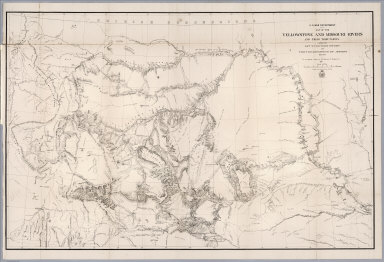
Author
Raynolds, W.F.
Full Title
U.S. War Department : Map of the Yellowstone and Missouri Rivers and their tributaries. Explored by Capt. W. F. Raynolds, TopL. Engrs. and 1st. Lieut. H. E. Maynadier, 10th. Infy. Assistant 1859-60. To accompany a report to the Bureau of Engineers 1867. Engraved in the Engineer Bureau, War Dept. (to accompany) Report of the Secretary of War, communicating ... the report of Brevet Brigadier General W.F. Raynolds, on the exploration of the Yellowstone and the country drained by that river.
List No
0833.003
Note
Uncolored map. Shows exploration routes, date of exploration, fortress, major cities, lakes and mountains. Relief shown by hachures and formlines.
Author
[Raynolds,W.F., Maynadier, H.E., Gillespie,G.]
Full Title
War Department Map Of The Yellowstone And Missouri Rivers And Their Tributaries explored by Capt. W.F. Raynolds Topl. Engrs. and 1st Lieut. H.E. Maynadier 10th Infy. Assistant. 1859-60. Revised and Enlarged by Major G.L. Gillespie ... 1876 ... Published by the authority of the Hon. the Secretary Of War Office of the Chief Of Engineers, U.S. Army. 1876. Engraved in the Office of the Chief of Engineers. Western Sheet Map Of Yellowstone And Missouri Rivers ... 1877.
List No
0834.000
Note
Map in 2 sheets; western sheet dated 1877. Highly detailed map, filling in much new information on the original map by Raynolds made in 1859-60 (but published in 1867). This map extends one degree further south than the original map, and for some reason the western sheet does not have the mountains drawn in although the water courses are clearly shown. Unfolded, separately issued on thin paper. Relief shown by hachures.
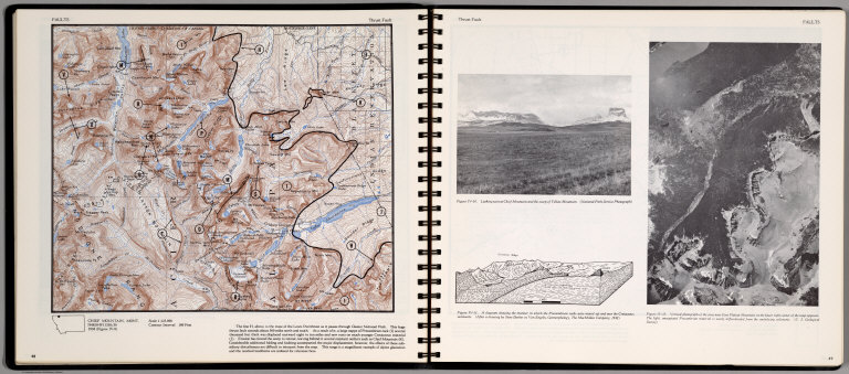
Author
[Scovel, James L., O'Brien, Emmett J]
Full Title
Faults. Trust Fault. Chief Mountain, Mont. (on opposite page) Trust Fault. Vertical photograph of the area near East Flat top Mountain ...
List No
0889.028
Note
Contour map, with location map. Insets: Looking West at Chief Mountain ..., and A Diagram showing the manner in which the Precambrian rocks were moved up and over Cretaceous sediments ... Relief shown by contours and spot height. Depth shown by soundings.
Author
[Scovel, James L., O'Brien, Emmett J]
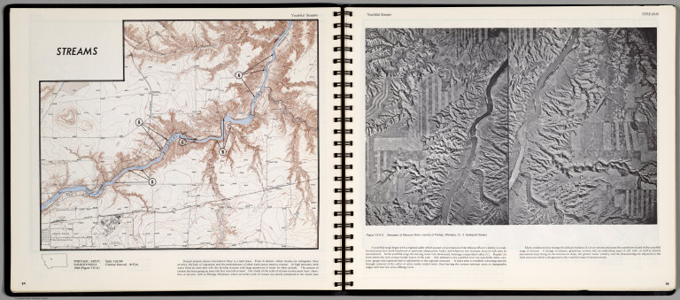
Full Title
Streams. Youthful Streams. Portage, Mont. (on opposite page) Youthful Streams. Stereopair of Missouri River, vicinity of Portage, Montana.
List No
0889.046
Note
Contour map, with text, and location maps. Relief shown by contours and spot heights.
Author
[Scovel, James L., O'Brien, Emmett J]
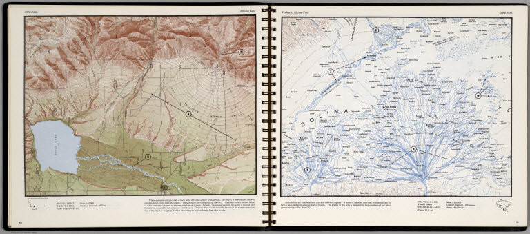
Full Title
Streams. Alluvial Fans. Ennis, Mont. (on opposite page) Coalesced Alluvial Fans. Kokan, U.S.S.R. Western Sberia. Scale 1:250,000.
List No
0889.053
Note
Two maps, with text, and location map. Relief shown by contours and spot heights.
Author
[Scovel, James L., O'Brien, Emmett J]
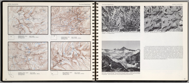
Full Title
Alpine Glaciation. The Cycle of Glacial Erosion. Georgetown, Colo. Scale 1:62,500. Cloud Peak, Wyo. Scale 1:125,000. Mineral King, Calif. Scale 1:62,500. Phillipsburg, Mont. Scale 1:125,000.(on opposite page three views of )The Cycle of Glacial Erosion.
List No
0889.057
Note
Four on one page, with text, and location map. Includes three views of Georgetown, Colorado; Cloud Peak, Wyoming; and A series of paternoster lakes in a maturely dissected glacial range. Relief shown by contours and spot heights.
Author
Lindgren Brothers
Full Title
A Hysterical Map of the Yellowstone Park with Apologies to the Park. Smileage Guaranteed. Lindgren Brothers. Spokane, Wash. C(opyright)1936.
List No
10036.000
Note
Adds mileage table - compare to our 6788.000. Color pictorial map. Humorous pictorial map "hatched & scratched by Jolly Lindgren" featuring the highlights of a visit to the park: showing hotels, peaks, lakes, geysers, etc. Relief shown pictorially and by spot heights. In 1933 the Lindgren Brothers of Spokane, Washington began manufacturing colorful silk-screened maps depicting iconic national parks and other scenic areas. With emphasis on both verbal and visual humor, they titled these inexpensive tourist souvenirs "Hysterical Maps," seeking to distinguish them from historical maps.
Author
Vandermaelen, Philippe, 1795-1869
Full Title
Partie de L'Oregon. Amer. Sep. 39... 1825
List No
10071.000
Note
This is an earlier variant edition of our 2212.244. Substantial changes to the topography. Hand col. lithographed map. Relief shown by hachures. Shows Indians tribes with populations, Lewis and Clarke's route, etc. Covers parts of Idaho, Montana and Wyoming.
Author
[Touring club italiano, Funk & Wagnalls Company.]
Full Title
(Legend to) Stati Uniti, United States of America, Montana, North Dakota, South Dakota, Wyoming, Nebraska. Propr. Artistico-letteraria del T.C.I. Ufficio cartografico del T.C.I. (1929)
List No
1012CQ
Note
Explanation to map.
Author
[Touring club italiano, Funk & Wagnalls Company.]
Full Title
Stati Uniti, United States of America, Montana, North Dakota, South Dakota, Wyoming, Nebraska. (with Yellowstone National Park). Propr. Artistico-letteraria del T.C.I. Ufficio cartografico del T.C.I. (1929)
List No
1012.073
Note
Color map. Relief shown by hachures and spot heights. Inset map at 1:750,000 scale.
Author
U.S. General Land Office
Full Title
(Map 12 - Montana, North Dakota).
List No
1071.014
Note
One of the series of adjacent sixteen maps. Mounted on linen. Relief shown in hachures.
Author
U.S. General Land Office
Full Title
(Map 16 - Washington, Oregon, Montana, Idaho).
List No
1071.018
Note
One of the series of adjacent sixteen maps. Mounted on linen. Relief shown in hachures.
Author
U.S. General Land Office
Full Title
Department of the Interior, General Land Office. S.S. Burdett, Commissioner. Territory of Montana. 1876. Compiled from the official records of the General Land Office and other sources by C. Roeser, Principal Draughtsman G.L.O. Photolith. & Print by Julius Bien 16 & 18 Park Place, N.Y.
List No
11179.016
Note
Color map. Includes references. Relief shown by hachures. Prime meridian is Greenwich.
Author
Rand McNally & Company
Full Title
Pictorial Map Idaho - Montana - Wyoming. Waterton-Glacier International Peace Park. Yellowstone National Park.
List No
12008.001
Note
Date estimated based on population note.
Author
Rand McNally & Company
Full Title
Idaho - Montana - Wyoming.
List No
12008.002
Note
Date estimated based on population note. Includes a western states mileage chart and a western states radio guide.
Author
Fletcher, Robert Henry
Full Title
Frontier - pioneer Montana : a one page history dedicated to the Old Timers. Historic data compiled by Bob Fletcher and Irvin Shope ; map and illustrations by Irvin Shope. Published by the Montana State Highway Department 1937. (cover title) A map of Montana whereon is depicted and inscribed the pioneer history of the land of shining mountains.
List No
13105.002
Note
Pictorial map on sheet 41x56, folded, with pictorial cover title. Representing roads, trails, historical events, major industries, fur posts, Indian settlements, wildlife, military forts and battles. Includes legend, State seal and notes. Relief shown pictorially. Descriptive text on verso "A tabloid history of Montana".
Author
[Lindgren, Jolly, Lindgren Brothers]
Full Title
A Hysterical map of the Red Lodge - Cooke Highway - The Cody Road - Big Horns Hell's Half Acre - Wind River Canyon and Dude Ranch Country. 1938 - Lindgren Brothers - Spokane, Wash.
List No
13335.000
Author
Stieler, Adolf, 1775–1836
Full Title
Petermann : Vereinigte Staaten Von Nord-Amerika In 6 Blattern, Bl. 1. Bearbeitet v. H. Habenicht. Gest v. Metzeroth, Eberhardt, Kramer. Stieler's Hand-Atlas No. 81. Gotha: Justus Perthes. 1875.
List No
13563.104
Note
1 outline color map on 6 sheets. Sheet 1. Title from sheet 4. shows Pacific Northwest, and parts of Montana, Wyoming, Utah, Nevada, and California.
Author
Shane, Ralph M.
Full Title
Key map of points of historical interest along the route of your Yellowstone River boat float. Ralph M. Shane, 1967 .
List No
13606.000
Author
[George F. Cram Company collection 1845-1955, National Highways Association]
Full Title
Montana. The George F. Cram Company, Chicago. (to accompany) Auto trails and commercial survey of the United States.
List No
13688.055
Note
State of Montana. Showing Transcontinental and named highways with number, State highways. Includes list of Transcontinental and state highways.
Author
[George F. Cram Company collection 1845-1955, National Highways Association]
Full Title
Montana. The George F. Cram Company, Chicago. (to accompany) Auto trails and commercial survey of the United States.
List No
13688.056
Note
State of Montana. Showing electric lines and administrative boundaries.
Author
Rand McNalley & Company
Full Title
Rand McNally road map : Montana.
List No
14003.030
Note
Road map of Montana, showing interstate and state highways, paved and dirt roads, as well as drainage and ports, and state and national parks. Includes compass rose, time zones, and bar scale with scale statement: One inch equals approximately 26 miles. Features legend indicating population. Copyright by Rand McNally & Company, Chicago, Ill. Lithographed in the U.S.A.
Author
[Bates, Ernest Sutherland, 1879-1939, Schiff, Herman S., Reeves, Norman, Smith, Robert E.]
Full Title
Montana, 1889.
List No
14244.091
Note
Pictorial map of Montana, showing political boundaries with bordering states. Features significant sites (Rocky Mts.), as well as natural resources and manufactured items (including sapphires, sheep, timber and dude ranches). Includes a compass rose and a scroll listing notable places and events - such as Lewis and Clark Expedition - which are pictured in vignettes below map, in order of listing. Map is 17 x 29 cm, on sheet 23 x 29 cm. Accompanied by historical text on facing page.
Author
Mid-West Map Company
Full Title
Highway map & guide of Montana. Mid-West Map Company, Aurora, Mo.
List No
14426.002
Note
Pocket road map for the state of Montana. Shows state boundaries, cities, highways, roads, airports, parks, topography, bodies of water and drainage. Relief shown with hachures. Includes explanatory text, a legend and bar scale given in miles. Indexed, with key on verso. With inset map: Yellowstone Natl. Park. Advertisements in margins. Printed in blue. Map is 40 x 53 cm, on sheet 44 x 56 cm. This copy has annotations in red pencil.
Author
Montana. State Highway Commission.
Full Title
General Highway and Transportation Map Fallon County Montana
List No
15298.011
Note
Dimensions are for full sheets.
Author
Montana. State Highway Commission.
Full Title
General Highway and Transportation Map Garfield County Montana sheet 1
List No
15298.012
Note
Dimensions are for full sheets.
Author
Montana. State Highway Commission.
Full Title
General Highway and Transportation Map Garfield County Montana sheet 2
List No
15298.013
Note
Dimensions are for full sheets.
Author
Montana. State Highway Commission.
Full Title
(Composite map of) General Highway and Transportation Map Garfield County Montana sheets 1- 2
List No
15298.052
Note
Dimensions are for full sheets.
Author
Montana. State Highway Commission.
Full Title
General Highway and Transportation Map Golden Valley County Montana
List No
15298.014
Note
Dimensions are for full sheets.
Author
Montana. State Highway Commission.
Full Title
General Highway and Transportation Map Hill County Montana sheet 1
List No
15298.015
Note
Dimensions are for full sheets.
Author
Montana. State Highway Commission.
Full Title
General Highway and Transportation Map Hill County Montana sheet 2
List No
15298.016
Note
Dimensions are for full sheets.
Author
Montana. State Highway Commission.
Full Title
(Composite map to) General Highway and Transportation Map Hill County Montana sheets 1- 2
List No
15298.053
Note
Dimensions are for full sheets.
Author
Montana. State Highway Commission.
Full Title
General Highway and Transportation Map Judith Basin County Montana
List No
15298.017
Note
Dimensions are for full sheets.
Author
Montana. State Highway Commission.
Full Title
General Highway and Transportation Map Liberty County Montana
List No
15298.018
Note
Dimensions are for full sheets.
Author
Montana. State Highway Commission.
Full Title
General Highway and Transportation Map McCone County Montana sheet 1
List No
15298.019
Note
Dimensions are for full sheets.
|


![[Hittin' the high spots in Montana].](https://www.davidrumsey.com/rumsey/Size2/RUMSEY~8~1/199/14466002.jpg)