|
Author
Burr, David H., 1803-1875
Full Title
Map of the northern parts of Ohio, Indiana and Illinois with Michigan and that part of the Ouisconsin territory lying east of the Mississippi River
List No
15634.000
Author
Cram, George Franklin, 1841-1928
Full Title
Michigan. 1899, by Geo. F. Cram.
List No
14372.076
Note
Map of Michigan. Shows political boundaries, counties, towns, railroads, steamship lines, topography, bodies of water, drainage, coastlines and islands. Relief shown with hachures. Includes key with explanation, latitudinal and longitudinal lines, as well as a bar scale given in miles. Two inset maps: Lake Superior -- L. Superior. With alphanumeric grid corresponding to "Index of Michigan" on pages 129-137 and 140. Colored lithograph. Map is 55 x 40 cm, on double sheet 67 x 45 cm. "Index of maps" and "Index of cities" in margins, providing navigation for atlas as a whole.
Author
Ensign & Thayer
Full Title
Pictorial Map of the Great West.
List No
15332.000
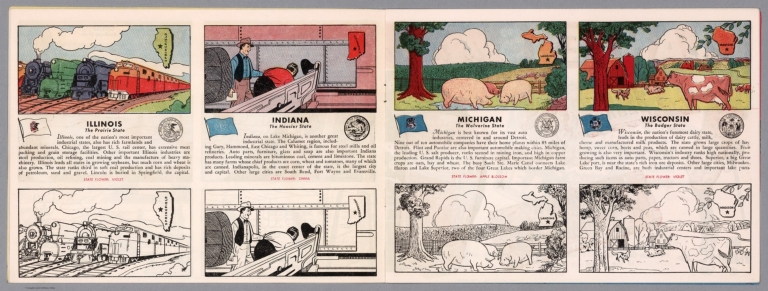
Author
[Fisher, Joseph R., Planters Peanuts (Firm)]
Full Title
Illinois : The prairie state -- Indiana : The hoosier state -- Michigan : The wolverine state -- Wisconsin : The badger state.
List No
14374.009
Note
Four views, representing Illinois, Indiana, Michigan and Wisconsin. Views show examples of the landscape and natural resources. Each view includes an inset map of the state, which marks the location of the capital city with a star. Accompanied by descriptive text, the state flags, seals and flowers: violet, zinnia, apple blossom and violet, respectively. The view of each state appears both in color (on top) and in black and white (bottom), the latter inviting coloration. Together, views are 18 x 52 cm, on two sheets 20 x 54 cm.
Author
Burr, David H., 1803-1875
Full Title
Michigan. Drawn and published by David H. Burr. New-York.
List No
14341.003
Note
Map of Michigan and vicinity, including the Great Lakes. Shows political boundaries, cities, roads, water routes, topography, vegetation, drainage, shorelines and islands. Relief shown with hachures. Features the "Indian boundary line according to the Saginaw Treaty." Includes a bar scale, given in American miles, as well as latitudinal and longitudinal lines. Hand-colored engraving. Map is 31 x 25 cm, on sheet 43 x 35 cm. "Entered according to act of Congress in the year 1831 by David H. Burr, in the Clerk's office of the District Court for the Southern District of New-York."
Author
Cram, George Franklin, 1841-1928
Full Title
Michigan. Geo. F. Cram, engraver and publisher, 262 and 264 Wabash Avenue, Chicago, Ill. 1882.
List No
14250.011
Note
Map of Michigan, showing railroads (both finished and unfinished), county boundaries, cities and towns, drainage and coastline, as well as ports and water distances across Lake Michigan. Political boundary lines in color. Includes a legend and a bar scale. Each of the Great Lakes pictured - Michigan, Superior and Huron - lists metrics for greatest length, breadth, depth, and height above sea. With index numbers along the perimeter, and decorative border. Also, with two inset maps: Isle Royale -- Dominion of Canada. 55 x 40 cm, on sheet 58 x 45 cm.
Author
[Weiland, Carl Ferdinand, 1782 -1847, Hassel, Georg, 1770-1829]
Full Title
Geographisch-statistische und historische Charte von Michigan.
List No
12293.017
Author
[Whitney-Graham Company, Inc., Detroit Edison Company]
Full Title
The Detroit Edison system. 4-28. (to accompany) The blue book of map making : America's map makers. R.W.C. The Whitney-Graham Co. Inc.
List No
11489.003
Note
Colored pictorial map. Shows 120,000 volt tower lines, transmission lines, heating, gas and water power plants and substations. Includes compass rose oriented with the north to the upper right margin. Relief shown by shadings.
Author
[Mitchell, John, Raynal, G.T., Zatta, Antonio]
Full Title
Il Paese de' Selvaggi Outagamiani, Mascoutensi, Illinesi e Parte delle VI. Nazioni. Fogl. IV.
List No
5007.006
Note
In outline color.
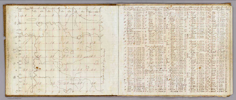
Author
Lyon, Lucius, 1800-1851
Full Title
(Case to) (Michigan and Indiana Border Survey 1828-1835. Manuscript survey maps and notes)
List No
5125A
Note
The surveyor's copper canister or tube 8 cm. in diam. It is fitted with a buckle on the side and the remains of leather strap on a hinged lid which fed through the buckle; also 6 copper loops soldered to side of canister. The image also shows the roll of maps and notes contained therein.
Author
Lyon, Lucius, 1800-1851
Full Title
(Covers to) (Michigan and Indiana Border Survey 1828-1835. Manuscript survey maps and notes)
List No
5125B
Note
Sheepskin cover.
Author
Lyon, Lucius, 1800-1851
Full Title
(Index to) (Michigan and Indiana Border Survey 1828-1835. Manuscript survey maps and notes)
List No
5125C
Note
List of 32 township maps with survey dates, and magnetic declination in degrees and minutes east. Seven of the maps are contained in this work. Pen-and-ink.
Author
Lyon, Lucius, 1800-1851
Full Title
(Text Page to) (Michigan and Indiana Border Survey 1828-1835. Manuscript survey maps and notes)
List No
5125D
Note
Notes on interior corners of sections in Township 7 S., R. 10 W. Pen-and-ink.
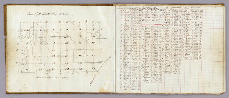
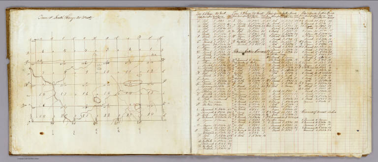
Author
Lyon, Lucius, 1800-1851
Full Title
Town 8 South, Range 20 West, Town 8 South, Range 19 West (Berrien County, Michigan, 1829)
List No
5125.001
Note
Colored manuscript map. Pen-and-ink. Shows sections, quarter sections, landowners, roads, hydrography, etc.
Author
Lyon, Lucius, 1800-1851
Full Title
Town 7 South, Rang[e] 19 West. Surveyed in 1829 by L. Lyon, varr. 5035' E.
List No
5125.002
Note
Colored manuscript map. Pen-and-ink and pencil. Shows sections, quarter sections, smaller parcels, landowners, roads, hydrography, etc. Located in Berrien County, Michigan. Facing the map is a table of courses and distances measuring 42 x 37 cm.
Author
Lyon, Lucius, 1800-1851
Full Title
Town 8 South, Range 19 West. (Surveyed in 1829 by L. Lyon)
List No
5125.003
Note
Colored manuscript map. Pen-and-ink and pencil. Shows sections, quarter sections, smaller parcels, landowners, roads, hydrography, etc. Located in Berrien County, Michigan on the "State line between Indiana & Michigan.". Facing the map is a table of courses and distances, 31 x 30 cm.
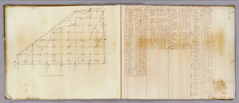
Author
Lyon, Lucius, 1800-1851
Full Title
Town 7 South, Range 20 West. (Surveyed in 1829 by L. Lyon). Road dists. in Chikaming Tp. in 1861 (added in pencil)
List No
5125.004
Note
Colored manuscript map. Pen-and-ink and pencil. Shows sections, quarter sections, smaller parcels, landowners, roads, hydrography, etc. Located in Berrien County, Michigan. Facing the map is a table of courses and distances, 32 x 37 cm.
Author
Lyon, Lucius, 1800-1851
Full Title
Town 8 South, Range 20 West. (Surveyed in 1829 by L. Lyon).
List No
5125.005
Note
Colored manuscript map. Pen-and-ink and pencil. Shows sections, quarter sections, landowners, hydrography, etc. Located in Berrien County, Michigan. Facing the map is a table of courses and distances, 31 x 31 cm.
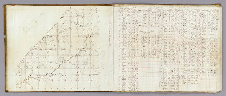
Author
Lyon, Lucius, 1800-1851
Full Title
T. 8 South, Range 21 West. (Surveyed in 1829 by L. Lyon).
List No
5125.006
Note
Colored manuscript map. Pen-and-ink and pencil. Shows sections, quarter sections, hydrography, "South Boundary of Michigan," etc. Located in Berrien County, Michigan. Facing the map is a table of courses and distances, 32 x 39 cm. Title from table.
Author
Lyon, Lucius, 1800-1851
Full Title
T. 7 South, R. 21 West. T. 8 S., Range 22 W. (Surveyed in 1829 by L. Lyon).
List No
5125.007
Note
Two colored manuscript maps on 1 sheet. Pen-and-ink. Show sections, quarter sections, hydrography, etc. Located in Berrien County, Michigan. Includes table of courses and distances.
Author
Appleton, D. & Co.
Full Title
Map of Michigan and Wisconsin. Copyright 1891 by Matthews-Northrup Co. ... Buffalo, New York. (insets) City of Milwaukee; City of Detroit; Isle Royale. (to accompany) The Library Atlas Of Modern Geography ... New York, D. Appleton And Company 1892. (on upper margin) Boston. 72.
List No
0026.188
Note
Color map. Shows county boundaries and county seat, capital, railways, roads, etc. "Size of type indicates importance of the places". Includes notes. Relief shown by hachures. Prime meridians are Greenwich and Washington.
Author
Appleton, D. & Co.
Full Title
Map of Detroit, Michigan. Copyright 1891 by Matthews-Northrup Co. ... Buffalo, New York. (to accompany) The Library Atlas Of Modern Geography ... New York, D. Appleton And Company 1892. (on upper margin) Detroit, 73.
List No
0026.192
Note
Color plan of Detroit. Shows railways, street car lines, blocks, parks, canals, etc. Includes numerical references to Depots, hotels, churches, major buildings, and points of interest.
Author
Arbuckle Bros.
Full Title
South Carolina, Wisconsin, Maine, Michigan. Copyright 1889 Arbuckle Bros. N.Y.
List No
0027.001
Note
Sheet with maps of four states in full color. The notes for Maine mention that the population included "8 Chinese." It is also noted that in Michigan although the climate in the winter is "cold and rigorous," the death rate is low. Each card measures 7.5 x 12.5 cm.
Author
Asher & Adams
Full Title
Asher & Adams' Michigan. Entered according to Act of Congress in the year 1874 by Asher & Adams ... at Washington. (New York, 1874)
List No
0041.020
Note
Hand col. engraved map. Shows townships, distances along railroads, etc. Inset map: Northwestern portion of Michigan. Prime meridians: Greenwich and Washington.
Author
[Bartholomew, John, Black, Adam & Charles]
Full Title
Michigan, Wisconsin, Iowa & Minnesota. Published by A. & C. Black. Edinburgh. Printed in Colours by Schenck & Macfariane. Edinburgh. Drawn & Engraved by J. Bartholomew, Edinburgh.
List No
0073.009
Note
States outlined in color. Land tinted.
Author
Bradford, Thomas G.
Full Title
Michigan. (inset) Northwest Part of Michigan. Entered ... 1838, by T.G. Bradford ... Massachusetts. Engraved by G.W. Boynton.
List No
0089.021
Note
In full color.
Full Title
Carte geographique, statistique et historique de Michigan. Territoire de Michigan. Grave par B. de Beaupre, rue de Vaugirard, No. 81, a Paris. Fonderie et Imprimerie de J. Carez. (1825)
List No
0102.036
Note
Hand colored engraved map. Relief shown by hachures. Excludes western part of northern peninsula. Text and tables at sides and bottom. Prime meridians: Washington and Paris.
Author
Burr, David H., 1803-1875
Full Title
Map of Michigan & Part Of Wisconsin Territory, Exhibiting the Post Offices, Post Roads, Canals, Rail Roads, &c. By David H. Burr. (Late Topographer to the Post Office.) Geographer to the House of Representatives of the U.S. John Arrowsmith. Entered ... July 10th, 1839, by David H. Burr ... District of Columbia.
List No
0104.013
Note
In full color by county. Wisconsin is shown in color only where territory has been sectioned. Postal routes by coach, stage, sulkey, cross, rail roads and canals shown. In 8 sections mounted on linen. Label on back states "No. 13. Michigan, Wisconsin."
Author
[Carey, H. C., Lea, I.]
Full Title
Geographical, Historical, And Statistical Map Of Michigan Territory. Michigan Territory. No. 36. Drawn by J. Finlayson. Engraved by Young & Delleker.
List No
0122.031
Note
In full color by region surrounded by text.
Author
Colton, G.W.
Full Title
Michigan. Published By J.H. Colton & Co. No. 172 William St. New York. Entered ... 1855 by J.H. Colton & Co. ... New York. No. 42.
List No
0149.047
Note
In full color by county.
Author
Colton, G.W.
Full Title
Lake Superior And The Northern Part Of Michigan. Published By J.H. Colton & Co. No. 172 William St. New York. Entered ... 1855 by J.H. Colton & Co. ... New York. No. 43.
List No
0149.048
Note
In full color. Information given on Lake Superior: 627 feet above the Ocean level, 900 feet deep and 32,000 square miles.
Author
Colton, G.W.
Full Title
Michigan. Published By J. H. Colton. No. 172 William St. New York.
List No
0151.053
Note
Map showing the county boundaries in color. Prime meridians are Greenwich and Washington D.C.
Author
Colton, G.W.
Full Title
Colton's Lake Superior and the Northern Part of Michigan. Published By J. H. Colton. No. 172 William St. New York.
List No
0151.054
Note
Prime meridians are Greenwich and Washington D.C.
Author
Colton, G.W.
Full Title
Michigan. Published By G. W & C. B. Colton & Co. No. 172 William St. New York.
List No
0152.052
Note
Prime meridians are Washington D.C. and Greenwich.
Author
Colton, G.W.
Full Title
Colton's Lake Superior and the Northern Part of Michigan. Published By G. W & C. B. Colton & Co. No. 172 William St. New York.
List No
0152.053
Note
Prime meridians are Washington D.C. and Greenwich.
Author
Colton, G.W. & C.B.
Full Title
(Covers to) Colton's Railroad & Commercial Atlas Of The United States, Canada Etc. Map No. 5. Michigan, Wisconsin & Minnesota. Published by G.W. & C.B. Colton. & Co. New York, 1869.
List No
0160.001
Note
This map is one of several pocket maps that Colton published as a "Railroad & Commercial Atlas of the United States..." These are probably descendants of an earlier series on the same scale that Colton published for H.V. Poor in 1860 - see Modelski North America plate 28 and Modelski 111 and 121. See also our #3940. These must have been among the largest scale regional railroad maps of the period. Full color by county, folded into stamped dark brown cloth covers 16x10 with "G. Woolworth Colton's County & Distance Railroad Map of Michigan, Wisconsin, & Minnesota. Showing every Station &c" in gilt. Prime meridians are Greenwich and Washington D.C.
Author
Colton, G.W. & C.B.
Full Title
Colton's Railroad & Commercial Atlas Of The United States, Canada Etc. Map No. 5. Michigan, Wisconsin & Minnesota. Published by G.W. & C.B. Colton. & Co. New York, 1869.
List No
0160.002
Note
This map is one of several pocket maps that Colton published as a "Railroad & Commercial Atlas of the United States..." These are probably descendants of an earlier series on the same scale that Colton published for H.V. Poor in 1860 - see Modelski North America plate 28 and Modelski 111 and 121. See also our #3940. These must have been among the largest scale regional railroad maps of the period. Full color by county, folded into stamped dark brown cloth covers 16x10 with "G. Woolworth Colton's County & Distance Railroad Map of Michigan, Wisconsin, & Minnesota. Showing every Station &c" in gilt. Prime meridians are Greenwich and Washington D.C.
Author
Cram, George Franklin
Full Title
New Rail Road and County Map of Michigan & Wisconsin.
List No
0210.040
Note
Prime meridians Greenwich and Washington.
Full Title
The state of Ohio with part of Upper Canada, &c. (Philadelphia: Robert DeSilver, 1827)
List No
0241.000
Note
Reissue from M. Carey's 1818 edition General Atlas. No changes from the 1818 edition. Outline color by county. Shows counties, settlements, roads, etc. Prime meridians: London and Philadelphia. "24."
Author
[Chapin, Gardner S., Rand McNally and Company, Schumacher, Arthur H.]
Full Title
Photo-auto maps (list. Compiled by Gardner S. Chapin and Arthur H. Schumacher. Copyright, 1907, by G.S. Chapin, Chicago. Published by the Motor Car Supply Co. ... The Automobile Supply Co. ... Chicago, Ill.)
List No
0268D
Note
List of maps in the Chicago, Detroit, Toledo and Cleveland divisions.
Author
Finley, Anthony
Full Title
Map of the States Of Ohio Indiana & Illinois And Part Of Michigan Territory Compiled from the Latest Authorities. D.H. Vance Del. J.H. Young Sc. Philada. Published by A. Finley 1825.
List No
0278.011
Note
In full color by county or region of the state. Statistical information includes mileage, population broken down by White Males, White Females, Free People of Colour, Slaves and Militia.
Author
Finley, Anthony
Full Title
Map of the States of Ohio, Indiana & Illinois and Part of the Michigan Territory, Complied from the Latest Athorities.
List No
0279.015
Author
Finley, Anthony
Full Title
Map of the States of Ohio, Indiana, & Illinois, and Part of the Michigan Territory, Compiled from the Latest Authorities. D.H. Vance Del., Philada. Published by A. Finley 1827. J.H. Young Sc.
List No
0280.011
Note
Relief shown by hachures. Prime meridian Washington. Statistical table for each state.
Author
Gray, O.W.
Full Title
Gray's Atlas Map of Michigan.
List No
0310.063
Author
Gray, O.W.
Full Title
Gray's Atlas Map of Lake Superior and the Northern Part of Michigan.
List No
0310.064
Author
[Gray, Frank A., Gray, O.W.]
Full Title
Lake Superior and the Northern Part of Michigan.
List No
0312.038
Author
[Colton, G.W., Colton, C.B., Gray, O.W.]
Full Title
Michigan. Copyright, 1874, by G.W. & C.B. Colton & Co.
List No
0312.039
Author
Johnson, A.J.
Full Title
Johnson's Wisconsin And Michigan Published By Johnson And Ward.
List No
0352.038
Note
Full color by county, with heavy outlines around the states. Shows railroads, and roads. Prime meridians are Greenwich and Washington D.C. Depth of water shown by isolines.
Author
Johnson, A.J.
Full Title
Johnson's Wisconsin and Michigan. Entered ... 1864.
List No
0358.043
Author
Leahy, J.F.
Full Title
(Index to) Leahy's Hotel Guide and Railway Distance Maps. Michigan.
List No
0425.058
Note
Alphabetical index list of the Hotels of the town with the number of rooms of each, their rates per day and the population of the town. Includes population of the states, Explanation of abbreviation of the railroad of the state, and advertisements.
Author
Leahy, J.F.
Full Title
Leahy's Hotel Guide and Railway Distance Map of the State of Michigan. Published by American Hotel Register Company. Leahy Build., 228-234 W. Ontario St., Chicago, Ill. Copyrighted by J.F. Leahy, Jan., 1934. (inset) Continuation of map.
List No
0425.059
Note
Map printed without color. Includes name of the railroad entering the town, and distance between towns.
Author
Leahy, J.F.
Full Title
(Index to) Leahy's Hotel Guide and Railway Distance Maps. Michigan.
List No
0425.060
Note
Alphabetical index list of the Hotels of the town with the number of rooms of each, their rates per day and the population of the town. Includes population of the states, Explanation of abbreviation of the railroad of the state, and advertisements.
Author
Leahy, J.F.
Full Title
Leahy's Hotel Guide and Railway Distance Map of the State of Michigan. Published by American Hotel Register Company. Leahy Build., 228-234 W. Ontario St., Chicago, Ill. Copyrighted by J.F. Leahy, Jan., 1934. (inset) Continuation of map.
List No
0425.061
Note
Map printed without color. Includes name of the railroad entering the town, and distance between towns.
Author
[Macomb, J. N. (John N.), Warner, William H. (William Hamer)]
Full Title
Map Of The Straits Of Detroit. Surveyed, Projected And Drawn By Lieutenants J.N. Macomb And W.H. Warner U.S. Corps Of Topl. Engs. 1840 '41 '42. Sheet No. 1. W.J. Stone Sc. Wash.
List No
0455.000
Note
Karpinski 728. Without color. Includes table, showing various states of water at different periods... Relief shown by hachures. Depths shown by soundings.
Author
[Macomb, J.N, Warner, W.H.]
Full Title
Chart Of Detroit River, From Lake Erie To Lake St. Slair. Surveyed In 1840, '41, & '42, By Lieutenants J.N. Macomb And W.H. Warner, Corps Of Topl. Engineers; Under The Direction Of Captain W.G. Williams,. Corps T. Engs.
List No
0456.000
Note
Karpinski 731; with 4 page report. Map is without color.Showing lengths of river and principal features near the shores on both sides. Includes a Table showing the various stage of water. Relief shown by soundings.
Author
Johnson, A.J.
Full Title
Johnson's Wisconsin And Michigan Published By Johnson And Ward.
List No
0535.036
Note
In full color by county. Relief shown by hachures. Meridians Greenwich and Washington D.C.
Author
Mitchell, Samuel Augustus
Full Title
A New Map Of Michigan with its Canals Roads And Distances. (with) Western Part Of Michigan. Published By S. Augustus Mitchell, N.E. corner of Market & 7th Street Philada., 1846. Entered ... 1846 by H.N. Burroughs ... Pennsylvania.
List No
0537.030
Note
In full color by county with steamboat route distances shown.
Author
Mitchell, Samuel Augustus
Full Title
A New Map of Michigan with its Canals, Roads & Distances. Published By S. Augustus Mitchell. N.E. corner of Market & 7th. Streets. Philadelphia. (inset map) Western Part of Michigan.
List No
0545.033
Note
Full color map. Includes explanation chart, and reference to steam boat routes. Prime meridian is Washington D.C.
Author
Mitchell, Samuel Augustus
Full Title
County Map Of Michigan, And Wisconsin. 34. Entered ... 1860, by S. Augustus Mitchell, Jr. ... Pennsylvania.
List No
0565.024
Note
Full color by county.
Author
Mitchell, Samuel Augustus Jr.
Full Title
County map of Michigan and Wisconsin. Drawn & Engraved by W.H. Gamble Philad. Entered ... 1863 by S. Augustus Mitchell, Jr. ... Pennsylvania.
List No
0572.035
Note
Full color map by county. Prime meridians are Greenwich and Washington, D.C.
Author
Mitchell, Samuel Augustus Jr.
Full Title
County map of Michigan and Wisconsin. Drawn & Engraved by W.H. Gamble Phila. Entered ... 1867 by S. Augustus Mitchell, Jr. ... Pennsylvania.
List No
0579.038
Note
Color map by county. Prime meridians are Greenwich and Washington, D.C.
Author
Mitchell, Samuel Augustus
Full Title
County and township map of the states of Michigan and Wisconsin. Drawn and engraved by W.H. Gamble, Philadelphia. Entered ... 1879 by S. Augustus Mitchell ... Washington. (1880)
List No
0586.037
Note
Hand colored. Shows settlements, railroads, rivers, etc. Prime meridians: Greenwich and Washington.
Author
Mitchell, Samuel Augustus
Full Title
Plan of Detroit. Entered ... 1879 by S. Augustus Mitchell ... Washington. (1880)
List No
0586.038
Note
Hand colored. Shows wards, railroads, major buildings, etc.
Author
Mitchell, Samuel Augustus Jr.
Full Title
County and township map of the states of Michigan and Wisconsin. Entered ... 1882 by S. Augustus Mitchell....
List No
0592.040
Note
Hand colored map. Shows settlements, railroads, rivers, etc. Prime meridians: Greenwich and Washington.
Author
Mitchell, Samuel Augustus Jr.
Full Title
Plan of the city of Detroit.
List No
0592.041
Note
Hand colored. Shows wards, railroads, major buildings, etc.
Full Title
County and township map of the states of Michigan and Wisconsin. (with) Isle Royale, Michigan. Drawn and engraved by W.H. Gamble, Philadelphia. Copyright 1887 by Wm. M. Bradley & Bro. (1890)
List No
0594.038
Note
Hand colored map with inset. Shows settlements, railroads, rivers, etc. Prime meridians: Greenwich and Washington.
Full Title
Plan of the city of Detroit. Copyright 1887 by Wm. M. Bradley & Bro. (1890)
List No
0594.039
Note
Hand colored. Shows wards, railroads, major buildings, etc.
Author
[Morse, Charles W., Colby, Charles A.]
Full Title
Michigan.
List No
0623.035
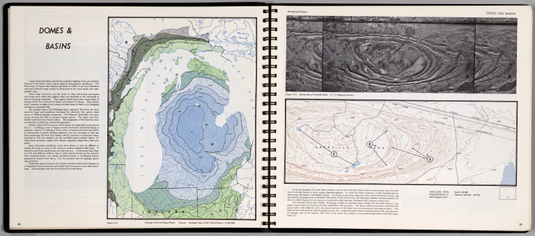
Author
[Scovel, James L., O'Brien, Emmett J]
Full Title
Domes & Basin. Geology of the Michigan Basin. (on opposite page) Anticlinal Domes. Sinclair, Wyo. 1:24,000. (with inset view) Stereotriplet of Grenville Dome).
List No
0889.016
Note
Contour maps on two pages, includes text, and outline location map. Relief shown by contours and spot height. Depth shown by gradient tints.
Author
Society for the Diffusion of Useful Knowledge (Great Britain)
Full Title
North America sheet III. Upper Canada with parts of New-York, Pennsylvania and Michigan. J. & C. Walker sc. Published by the Society for the Diffusion of Useful Knowledge. Published September 1st. 1832 by Baldwin & Cradock, 47 Paternoster Row, London. (London: Chapman & Hall, 1844)
List No
0890.130
Note
Engraved map. Relief shown by hachures. County boundaries hand col.
Author
Society for the Diffusion of Useful Knowledge (Great Britain)
Full Title
North America sheet IV. Lake Superior. J. & C. Walker sculpt. Published under the superintendence of the Society for the Diffusion of Useful Knowledge. Published Nov. 1st. 1832 by Baldwin & Cradock, 47 Paternoster Row, London. (London: Chapman & Hall, 1844)
List No
0890.131
Note
Engraved map. Relief shown by hachures. County boundaries hand col. Source: Tanner.
Author
Society for the Diffusion of Useful Knowledge (Great Britain)
Full Title
North America sheet V. The North West and Michigan territories. J. & C. Walker sculpt. Published by Baldwin & Cradock under the superintendence of the Society for the Diffusion of Useful Knowledge, April 1st. 1833. Printed by Russell, Penge. (London: Chapman & Hall, 1844)
List No
0890.132
Note
Engraved map. Relief shown by hachures. County boundaries hand col. Source: Tanner.
Author
Tanner, Henry S.
Full Title
A New Map of Michigan with Its Canals, Roads & Distances by H.S. Tanner.
List No
0976.031
Author
Tanner, Henry S.
Full Title
A New Map Of Michigan with its Canals, Roads & Distances: By H.S. Tanner. Engd. by E.B. Dawson. Entered ... 1833 by H.S. Tanner ... Pennsylvania. Published by H.S. Tanner, Philadelphia. (above neat line) Tanner's Universal Atlas.
List No
0977.026
Note
In full color by county with steamboat route distances charted.
Author
Tanner, Henry S.
Full Title
A New Map of Michigan with Its Canals, Roads & Distances by H.S. Tanner.
List No
0980.031
Author
[Touring club italiano, Funk & Wagnalls Company.]
Full Title
(Legend to) Stati Uniti, United States of America, Michigan, Wisconsin, Minnesota, Iowa, Missouri, Illinois, Indiana, Kentucky. Propr. Artistico-letteraria del T.C.I. Ufficio cartografico del T.C.I. (1929)
List No
1012CP
Note
Explanation to map.
Author
[Touring club italiano, Funk & Wagnalls Company.]
Full Title
Stati Uniti, United States of America, Michigan, Wisconsin, Minnesota, Iowa, Missouri, Illinois, Indiana, Kentucky. Propr. Artistico-letteraria del T.C.I. Ufficio cartografico del T.C.I. (1929)
List No
1012.072
Note
Color map. Relief shown by hachures and spot heights; depths by isolines. Includes inset map at 1:250,000 of the Chicago region.
Author
United States. Post Office Department
Full Title
Post Route Map of States of Michigan and Wisconsin with Adjacent Parts of Ohio, Indiana, Illinois, Iowa and Minnesota.
List No
10438.002
Note
Updated to 1879 from 1871. 12 panels.
Author
U.S. General Land Office
Full Title
Sketch of the Public Surveys in Michigan. To accompany the annual Report of the Commissioner, Genl. Land Office. Department of the Interior, General Land Office, October 2nd 1866. Jo. S. Wilson, Commissioner. Bowen & Co. lith. Philada. (with) inset map of Isle Royale.
List No
1070.004
Note
Large map showing the Land Office; railroads; wagon roads; and the copper, iron and silver regions. In outline color.
Author
U.S. General Land Office
Full Title
(Map 7 - Iowa, Indiana, Illinois, Michigan, Wisconsin, Minnesota, Missouri).
List No
1071.009
Note
One of the series of adjacent sixteen maps. Mounted on linen.
Author
U.S. General Land Office
Full Title
(Map 8 - Minnesota, Wisconsin, Michigan).
List No
1071.010
Note
One of the series of adjacent sixteen maps. Mounted on linen.
Author
Society for the Diffusion of Useful Knowledge (Great Britain)
Full Title
North America Sheet III, West Canada with Parts of New York, Pennsylvania and Michigan.
List No
10911.074
Author
[Bayley, W.S., Smyth, H. L., Van Hise, C.]
Full Title
(Covers to) Department Of The Interior, United States Geological Survey, Charles D. Walcott, Director. Atlas To Accompany Monograph XXVIII On The Marquette Iron-Bearing District Of Michigan By Charles Richard Van Hise And William Shirley Bayley With A Chapter On The Republic Through By Henry Lloyd Smyth. Washington 1896. Julius Bien & Co. Lith. N.Y.
List No
1111A
Note
Bound in original brown cloth covered boards with "United States Geological Survey, Charles D. Walcott, Director. Altas To Accompany Monograph XXVIII On The Marquette Iron-Bearing District Of Michigan. Van Hise, Bayley, Smyth" stamped in gilt.
Author
[Bayley, W.S., Smyth, H. L., Van Hise, C.]
Full Title
(Title Page to) Department Of The Interior, United States Geological Survey, Charles D. Walcott, Director. Atlas To Accompany Monograph XXVIII On The Marquette Iron-Bearing District Of Michigan By Charles Richard Van Hise And William Shirley Bayley With A Chapter On The Republic Through By Henry Lloyd Smyth. Washington 1896. Julius Bien & Co. Lith. N.Y.
List No
1111B
Author
[Bayley, W.S., Smyth, H. L., Van Hise, C.]
Full Title
(Table of Contents to) Department Of The Interior, United States Geological Survey, Charles D. Walcott, Director. Atlas To Accompany Monograph XXVIII On The Marquette Iron-Bearing District Of Michigan By Charles Richard Van Hise And William Shirley Bayley With A Chapter On The Republic Through By Henry Lloyd Smyth. Washington 1896. Julius Bien & Co. Lith. N.Y.
List No
1111C
Author
[Bayley, W.S., Smyth, H. L., Van Hise, C.]
Full Title
(Legend to) Department Of The Interior, United States Geological Survey, Charles D. Walcott, Director. Atlas To Accompany Monograph XXVIII On The Marquette Iron-Bearing District Of Michigan By Charles Richard Van Hise And William Shirley Bayley With A Chapter On The Republic Through By Henry Lloyd Smyth. Washington 1896. Julius Bien & Co. Lith. N.Y.
List No
1111D
Note
Provides a key map and description of geology and atlas.
Author
[Bayley, W.S., Smyth, H. L., Van Hise, C.]
Full Title
General Geological Map of the Marquette District. By C.R. Van Hise and W.S. Bayley. Julius Bien & Co. Lith. N.Y.
List No
1111.001
Note
Includes colored geologic map with 19 rock types, faults, and numerous cross sections. Contour interval 50 feet. Fold-out sheet.
Author
[Bayley, W.S., Smyth, H. L., Van Hise, C.]
Full Title
Detailed Geology Sheet V. (T 48 N, R 30 W, SW Quarter). Julius Bien & Co. Lith. N.Y.
List No
1111.002
Note
Relief shown by 20-foot contours. Colored geologic map shows railroads, roads, trails, settlements, swamps, streams, lakes, rock types, and outcrops. Geologic cross sections included.
Author
[Bayley, W.S., Smyth, H. L., Van Hise, C.]
Full Title
Detailed Geology Sheet VI. (T 47 N, R 30 W, NW Quarter). Julius Bien & Co. Lith. N.Y.
List No
1111.003
Note
Relief shown by 20-foot contours. Colored geologic map shows railroads, roads, trails, settlements, swamps, streams, lakes, rock types, and outcrops. Geologic cross sections included.
Author
[Bayley, W.S., Smyth, H. L., Van Hise, C.]
Full Title
Detailed Geology Sheet VII. (T 47 N, R 30 W, SW Quarter). Julius Bien & Co. Lith. N.Y.
List No
1111.004
Note
Relief shown by 20-foot contours. Colored geologic map shows railroads, roads, trails, settlements, swamps, streams, lakes, rock types, and outcrops. Geologic cross sections included.
Author
[Bayley, W.S., Smyth, H. L., Van Hise, C.]
Full Title
Detailed Geology Sheet VIII. (T 48 N, R 30 W, SE Quarter). Julius Bien & Co. Lith. N.Y.
List No
1111.005
Note
Relief shown by 20-foot contours. Colored geologic map shows railroads, roads, trails, settlements, swamps, streams, lakes, rock types, and outcrops. Geologic cross sections included.
Author
[Bayley, W.S., Smyth, H. L., Van Hise, C.]
Full Title
Detailed Geology Sheet IX. (T 47 N, R 30 W, NE Quarter). Julius Bien & Co. Lith. N.Y.
List No
1111.006
Note
Relief shown by 20-foot contours. Colored geologic map shows railroads, roads, trails, settlements, swamps, streams, lakes, rock types, and outcrops. Geologic cross sections included.
Author
[Bayley, W.S., Smyth, H. L., Van Hise, C.]
Full Title
Detailed Geology Sheet X. (T 47 N, R 30 W, SE Quarter). Julius Bien & Co. Lith. N.Y.
List No
1111.007
Note
Relief shown by 20-foot contours. Colored geologic map shows railroads, roads, trails, settlements, swamps, streams, lakes, rock types, and outcrops. Geologic cross sections included.
Author
[Bayley, W.S., Smyth, H. L., Van Hise, C.]
Full Title
Detailed Geology Sheet XI. (T 46 N, R 29 and 30 W, southern part of the Republic Trough). Julius Bien & Co. Lith. N.Y.
List No
1111.008
Note
Relief shown by 20-foot contours. Colored geologic map shows railroads, roads, trails, settlements, swamps, streams, lakes, rock types, and outcrops. Geologic cross sections included.
Author
[Bayley, W.S., Smyth, H. L., Van Hise, C.]
Full Title
Detailed Geology Sheet XII. (T 48 N, R 29 W, SW Quarter). Julius Bien & Co. Lith. N.Y.
List No
1111.009
Note
Relief shown by 20-foot contours. Colored geologic map shows railroads, roads, trails, settlements, swamps, streams, lakes, rock types, and outcrops. Geologic cross sections included.
Author
[Bayley, W.S., Smyth, H. L., Van Hise, C.]
Full Title
Detailed Geology Sheet XIII. (T 47 N, R 29 W, NW Quarter). Julius Bien & Co. Lith. N.Y.
List No
1111.010
Note
Relief shown by 20-foot contours. Colored geologic map shows railroads, roads, trails, settlements, swamps, streams, lakes, rock types, and outcrops. Geologic cross sections included.
Author
[Bayley, W.S., Smyth, H. L., Van Hise, C.]
Full Title
Detailed Geology Sheet XIV. (T 47 N, R 29 W, SW Quarter). Julius Bien & Co. Lith. N.Y.
List No
1111.011
Note
Relief shown by 20-foot contours. Colored geologic map shows railroads, roads, trails, settlements, swamps, streams, lakes, rock types, and outcrops. Geologic cross sections included.
Author
[Bayley, W.S., Smyth, H. L., Van Hise, C.]
Full Title
Detailed Geology Sheet XV. (T 48 N, R 29 W, SE Quarter). Julius Bien & Co. Lith. N.Y.
List No
1111.012
Note
Relief shown by 20-foot contours. Colored geologic map shows railroads, roads, trails, settlements, swamps, streams, lakes, rock types, and outcrops. Geologic cross sections included.
Author
[Bayley, W.S., Smyth, H. L., Van Hise, C.]
Full Title
Detailed Geology Sheet XVI. (T 47 N, R 29 W, NE Quarter). Julius Bien & Co. Lith. N.Y.
List No
1111.013
Note
Relief shown by 20-foot contours. Colored geologic map shows railroads, roads, trails, settlements, swamps, streams, lakes, rock types, and outcrops. Geologic cross sections included.
Author
[Bayley, W.S., Smyth, H. L., Van Hise, C.]
Full Title
Detailed Geology Sheet XVII. (T 47 N, R 29 W, SE Quarter). Julius Bien & Co. Lith. N.Y.
List No
1111.014
Note
Relief shown by 20-foot contours. Colored geologic map shows railroads, roads, trails, settlements, swamps, streams, lakes, rock types, and outcrops. Geologic cross sections included.
|