|
Author
Mitchell, Samuel Augustus
Full Title
Mitchell's New National Map Exhibiting The United States With The North American British Provinces, Sandwich Islands, Mexico And Central America, Together with Cuba and other West India Islands. Philadelphia, Published By S. Augustus Mitchell. 1856. Engraved by W. Williams, Map Engraver Philadelphia. Constructed And Engraved By W. Williams, 33 South Fifth St. Philadelphia. Entered ... 1855 by S. Augustus Mitchell Jr. ... Pennsylvania. (inset) Map Of The World On The Mercator Projection ... (inset) Map Of The World On The Globular Projection ... (inset) Map Of The Sandwich Islands ...
List No
2292.000
Author
Andriveau-Goujon, Eugene
Full Title
(Composite Map) Carte Generale des Etats - Unis et du Mexique : Comprenant L'Amerique Centrale Et Les Antilles. E. Andriveau-Goujon, Editeur. Paris, Rue Du Bac, 21. 1862. (to accompany) Atlas classique et universel de geograparphie ancienne et moderne ... Nouvelle edition. 1863.
List No
13421.062
Note
Composite map of sheets 47-48: Etats - Unis et du Mexique.
Author
Andriveau-Goujon, E.
Full Title
Carte Generale Des Etats - Unis Et Du Mexique Comprenant L'Amerique Centrale Et Les Antilles. E. Andriveau-Goujon, Editeur. Paris, Rue Du Bac, 21. 1860. Dressee par A. Vuillemin ... (with four inset maps).
List No
15650.000
Author
Andriveau-Goujon, E. (Eugène), 1832-1897
Full Title
(24) Carte générale des États-Unis et du Mexique comprenant l'Amérique centrale et les Antilles. E. Andriveau-Goujon, éditeur. Paris, Rue du Bac, 4. Nouvelle édition, 1876.
List No
14008.028
Note
Hand-colored, engraved map of the United States, Mexico, Central America and the Antilles, showing railroads and water routes (on double plate with decorative border). Includes legend indicating European colonies (French, English, Dutch, Danish, Spain and Swedish), as well as 4 bar scales. "No. 24" in upper right. With 4 insets: États de l'Amérique Centrale -- Entré de New-York -- Carte des rapports entre l'Europe & l'Amérique -- Petites Antilles et Nord de l'Amérique du Sud.
Author
[Hickmann, Anton Leo, 1834-1906, Fischer, Alois, b. 1894]
Full Title
Nord-Amerika. G. Freytag & Berndt A.G., Wien. (to accompany) Prof. Hickmann's Geographisch-statistischer universal-atlas, 1927.
List No
13687.035
Note
Political map of North America. Showing political boundaries, cities, topography, bodies of water, coastlines, islands. railways, steamship routes and distances. Includes color reference to European possessions. Relief shown by hachures and spot heights. Prime meridian: Greenwich.
Author
[Hickmann, Anton Leo, 1834-1906, Fischer, Alois, b. 1894]
Full Title
Vereinigte Staaten von. Amerika und Mexico. G. Freytag & Berndt A.G., Wien. (to accompany) Prof. Hickmann's Geographisch-statistischer universal-atlas, 1927.
List No
13687.036
Note
Map of the United states of. America and Mexico. Showing political and administrative divisions, cities, topography, bodies of water, coastlines, islands. railways, steamship routes and distances. Includes legend and list of States. Relief shown by hachures and spot heights. Prime meridian: Greenwich.
Author
Williams, G. Washington
Full Title
Williams' Copper - Plate Map Of The United States, Canada, Mexico, Central America, West Indies, &c. Published by John M. Atwood, 402 Locust Street, Philadelphia. Printed by F. Bourquin, 31 So. 6th Street, Phila. Copyright 1876 by G. Washington Williams.
List No
3030.002
Author
[White, Ruth Taylor, Western Air Express]
Full Title
Los Angeles to Tia Juana or Agua Caliente : 116 miles - 1 hour. Los Angeles to Catalina : 45 miles - 30 minutes. Over land and sea. Cartograph by Ruth Taylor White. (to accompany) Western Air Express Travel by Air : Travel by Western Air Express : Speend - comfort - dependability. Cartograph by Ruth Taylor White. Printed in U.S.A. in October, 1929.
List No
11777.004
Note
Double page pictorial map. Showing Western Air express routes, flying times and distance, major cites landmarks, forest, winter and Summer sports, recreational activities, places of interest, industry, farms, rivers and mountains. Relief shown pictorially. Includes text, photos and compass rose decorated with arrowhead logo.
Author
Colton, G.W. & C.B.
Full Title
Colton's Map Of The United States Of America, The British Provinces, Mexico and the West Indies. Showing the Country from the Atlantic to the Pacific Ocean. Published by G.W. And C.B. Colton & Co. 172 William St. New York. 1871. (inset) The Eastern Portion Of The West India Islands ...
List No
3323.002
Author
Rand McNalley & Company
Full Title
(Covers to) Road atlas : Supplement to Rand McNally commercial atlas service. Rand McNally & Company, Publishers, New York, Chicago, San Francisco.
List No
14003.001
Note
Includes "Quick Index" listing states with page numbers. Bound in green paper wrappers. "By issuing the Road Maps in this single volume we are able to give subscribers for the Commercial Atlas Service a complete series (United States, Canada, and Mexico) based on the latest information available at the time of publication."
Author
Rand McNalley & Company
Full Title
Rand McNally road atlas of the United States, Canada and Mexico. Rand McNally & Company, New York, Chicago, San Francisco.
List No
14003.002
Note
Includes Indexes: State and province maps -- City Maps. Table of contents lists: A guide to places of interest -- Mileage map of the United States -- Mileage chart of the United States -- Mileage chart of Mexico -- Motoring in Canada and Mexico. Copyright 1948 by Rand McNally & Company, Chicago. Made in U.S.A.
Author
Vuillemin, Alexandre
Full Title
Geographie commercial et industriel : Nouvelle carte illustree de l'Amerique du Nord : indiquant les grandes divisions physiques, la distribution geographique des vegetaux et des mineraux, les ports de commerce, villes industrielles et fortifiees des differents etats. Dressee par A. Vuillemin. Gravee par Langevin. Paris, Chez Fatout, Editeur. 1857. Grave sur acier, la topographie par Gerin, le trait au burin par F. Lefevre, Les illustrations dessinees par A. Testard et gravees par Guesnu. Imp. par Mangeon. Paris. (to accompany) Atlas de geographie commercial et industriel.
List No
13375.006
Note
Engraved outline hand color map of North America. Includes 14 vignette views of different countries in North America, European colonies, and 2 sections of fruits and plants in panels at sides. Includes tables, legend and notes.
Author
[Pasa, Ali Seref, Esref, Hafiz Ali]
Full Title
Amerika-yi şimali = North America. 1309 (1893). Tabie ve Nnashiri Hasan Ferid. (to accompany) Yeni cografya atlasi - ىگى جغرافىا آطلسى = New geographical atlas. Dersa'adet (Istanbul), 1307-1309 (1891-1893).
List No
13621.008
Note
Map of North America. Covers Central America. Shows political and state boundaries.
Author
Silishchensky, Mitrofan Ivanovich 1878 - 1944
Full Title
Sev. Amer. Soyedinennyye shtaty, Meksika i Yuzhnaya. Kanada : Ekonomicheskaia karta. Prof. M. I. Silishchenskiy. "Geokartprom" Typo-Lithography and M.T. Dunaeva, Moscow. (to accompany) Geograficheskiy atlas Chast 1.
List No
13461.043
Note
Economic map of North. America. Covers part of Central America. Includes legend and tables.
Author
Babson's Statistical Organization, Inc.
Full Title
Babson's map of North America for merchants and bankers : published in connection with Babson's reports on fundamental conditions. Compiling Offices: Welleley Hills, Mass. Copyright 1916, by Babson's Statistical Organization. historic first photo of earth from deep
List No
13667.000
Author
American Airlines Inc.
Full Title
Air Map. Route of the flagships uniting Canada, U.S.A. and Mexico. American Airlines Inc.
List No
14038.000
Note
Issued as an advertisement in a magazine, with summary of the air age, and how it applies to our world view. Mankind is no longer dependent on water or land to travel, so those elements are removed from the map. And what you are left with is a totally different take on who your neighbors are. Showing just city names and their approximate distance, it is a new view that would change everything. Date estimated. Map 23 x 23 cm, on sheet 36 x 26 cm. "Reprints of this advertisement available upon request. Address American Airlines, Inc. Dept. 'B.' New York Airport Station, New York." (See Pub List No. 11632.000 for reprint copy.)
Author
[Chatelain Henri, 1684-1743, Gueudeville, Nicolas]
Full Title
Carte Contenant le Royaume du Mexique et la Floride dressez sur les meilleures observations & sur les memoires les plus nouveaux. Tom. VI. No. 27. Pag. 101. (to accompany) Atlas Historique ... Tome VI. A Amsterdam, chez L'Honore & Chatelain Libraires. M DCC XIX (1719).
List No
13272.698
Note
Engraved map of North America and the West Indies, from Newfoundland and the Great Lakes to northern South America, based on de L'Isle's map of the southern part of North America. Covers New Mexico, Louisiana, from Florida through present-day Texas and the Gulf Coast region. Shows political boundaries, Indian settlements, cities, towns, ports, rivers, and notes the discoveries along the Gulf Coast and Mississippi River. Includes text. Relief shown pictorially.
Author
Vuillemin, Alexandre
Full Title
Geographie commerciale et industrielle : Nouvelle carte illustree de l'Amerique du Nord : Indiquant Les Grandes Divisions Physiques, La Distribution Geographique Des Vegetaux Et Mineraux ... Dressee par A. Vuillemin. Gravee par Langevin. Paris, Chez Fatout, Editeur. 1861. Grave sur acier, Grave: la Topographie par Gerin, le trait au burin par F. Lefevre. Les illustrations dessinees par A. Testard et gravees par Guensu. Imprime par Mangeon. Paris. (to accompany) Atlas illustre de geographie commerciale et industrielle.
List No
13376.019
Note
Engraved outline hand color map. Including 16 vignettes views showing indigenous people in North America and 2 sections of fruits and plants in panels at sides. Map shows Russian America, Utah & New Mexico extending to the Rocky Mountains, Oregon, Northwest and Indian Territories, early discoveries, including a reference to Alvaro Nunez in Texas in 1528, Cabrillo's discovery of the Pacific in 1548, Francis Drake, Lewis & Clark and Edwin James. Includes legend, tables, color coded table of European colonies in the region and notes.
Author
Holgate, Jerome B., 1812-1893
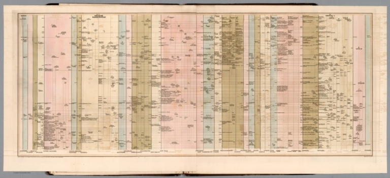
Full Title
(Timeline chart). Engraved by G.W. Boynton. Entered according to Act of Congress in the year one thousand eight hundred and forty-two, by Jerome B. Holgate ... Massachusetts. (to accompany) Atlas of American history on a novel plan ... By Jerome B. Holgate. 1842.
List No
13300.008
Note
Engraved timeline chart, 1402- 1598.
Author
Holgate, Jerome B., 1812-1893
Full Title
(Timeline chart). G.W. Boynton, Sc. Entered according to Act of Congress in the year one thousand eight hundred and forty-two, by Jerome B. Holgate ... Massachusetts. (to accompany) Atlas of American history on a novel plan ... By Jerome B. Holgate. 1842.
List No
13300.009
Note
Engraved timeline chart, 1602-1672.
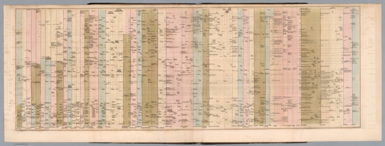
Author
Holgate, Jerome B., 1812-1893
Full Title
(Timeline chart). G.W. Boynton, Sc. Entered according to Act of Congress in the year one thousand eight hundred and forty-two, by Jerome B. Holgate ... Massachusetts. (to accompany) Atlas of American history on a novel plan ... By Jerome B. Holgate. 1842.
List No
13300.010
Note
Engraved timeline chart, 1673-1721.
Author
Holgate, Jerome B., 1812-1893
Full Title
(Timeline chart). G.W. Boynton, Sc. Entered according to Act of Congress in the year one thousand eight hundred and forty-two, by Jerome B. Holgate ... Massachusetts. (to accompany) Atlas of American history on a novel plan ... By Jerome B. Holgate. 1842.
List No
13300.011
Note
Engraved timeline chart, 1724-1763.
Author
Holgate, Jerome B., 1812-1893
Full Title
(Timeline chart). Engraved by G.W. Boynton. Entered according to Act of Congress in the year one thousand eight hundred and forty-two, by Jerome B. Holgate ... Massachusetts. (to accompany) Atlas of American history on a novel plan ... By Jerome B. Holgate. 1842.
List No
13300.012
Note
Engraved folded timeline chart, 1764-1782.
Author
Holgate, Jerome B., 1812-1893
Full Title
(Timeline chart). Engraved by G.W. Boynton. Entered according to Act of Congress in the year one thousand eight hundred and forty-two, by Jerome B. Holgate ... Massachusetts. (to accompany) Atlas of American history on a novel plan ... By Jerome B. Holgate. 1842.
List No
13300.013
Note
Engraved folded timeline chart, 1797-1841.
Author
Baur, Carl Friedrich
Full Title
Vereinigte Staaten und Mexiko. Entworfen u. gezeichnet v. C. F. Baur. Bassermannsche Verlagshandlung in Mannheim. B. Walther lith. (to accompany) Atlas fur Handel u. Industrie, fur Kaufleute, Fabrikanten u. Gewerbetreibende ... von C.F. Baur. 1857.
List No
13199.049
Note
Color map. Includes color coded reference. Shows political and administrative boundaries, major cities, roads and shipping routes. Includes list of 24 States in Unite States and 20 Mexican States.
Author
[Stieler, Adolf, Petermann, A., Lueddecke, R.]
Full Title
(Composite Map) West-Indien in 4 Blaettern, Bl.4.
List No
2207.050
Author
[Brion de La Tour, Louis, 1743 – 1803, Desnos, Louis Charles]
Full Title
Nouveau Mexique, Louisiane, Canada, et les Etats Unis. Par M. Brion. A Paris, chez le Sr. Desnos. A.P.D.R. 1786. (to accompany) Atlas general, civil, ecclesiastique et militaire, methodique et elementaire pour l'etude de la geographie et de l'histoire ... par M. Brion, dirige par le sr. Desnos … A Paris 1786.
List No
13129.057
Note
Engraved hand color map. Two long rivers run from California to the Rocky Mountain region. Shows American Indian settlements. Louisiana is divided into two regions, Floride, which contains all of the territory between the appellations and the Mississippi, and Louisiana proper. Relief shown pictorially. Includes note regarding explorations along the Northwest Coast of America. Includes decorative engraved title cartouche and border.
Author
Aa, Pieter van der, 1659-1733
Full Title
L'Amerique septentrionale, Suivant les nouvelles observations de Messrs ... A Leide, Chez Pierre Van der Aa. (to accompany) Nouvel Atlas, tres-exact et fort commode pour toutes sortes de personnes, Contenant les Principales Cartes Geographiques ...
List No
11691.101
Note
Full color map of North America and the West Indies. Centered on the Great lakes, covers from Baffin Bay to the Amerique Meridionale, including Florida, New Mexico, New Spain (Mexico), California, Nouvelle France, and the Hudson Bay. California is not clear whether it is an island or not. The Gulf of California is left open ended, Parts of California are identified as New Albion. The exploration routes used by d'Oliver, Cortez, and Drake are shown in dote lines to the west of Mexico. Map showing political and administrative boundaries and settlements. Relief shown pictorially. Includes decorative title cartouche.
Author
[Weiland, Carl Ferdinand, 1782 -1847, Hassel, Georg, 1770-1829]
Full Title
Geographisch-statistische und historische Charte von Mexico.
List No
12293.046
Note
Date estimated.
Author
American Airlines Inc.
Full Title
Air Map. Route of the flagships uniting Canada, U.S.A. and Mexico. American Airlines Inc.
List No
11632.000
Note
Issued first as an advertisement, with summary of the air age, and how it applies to our world view. Mankind is no longer dependent on water or land to travel, so they are removed from the map. And what you are left with is a totally different take on who your neighbors are. Showing just city names and their approximate distance, it is a new view that would change everything. Date estimated.
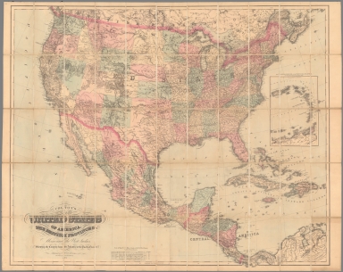
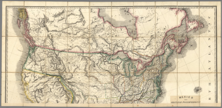
Author
Wyld, James, 1812-1887
Full Title
(Covers to) Mexico The British Possessions In North America And The United States. London. Published By Jas. Wyld, Geographer To The Queen, Charing Cross East. 1846. James Wyld, Geographer to the Queen and to H.R.H. Prince Albert, Charing Cross, East, four doors from Trafalgar Square, London ... (inset) North America. (inset) Islands in the Pacific Ocean.
List No
2747.001
Note
Dissected in north and south sheets, each in 30 sections. This map is a reduction and reissue of Wyld's famous 1824 Map of North America (Stevens and Tree 63 - four editions from 1824 to 1856) - it does not have the top sheet showing the Arctic, it moves the title from the lower left to middle right (and changes title of course), and it updates some of the western geography, showing the Tule Lakes in California, Fremont's or South Pass, Fts Hall and Boise and the Oregon Trail. However, it keeps the outdated topography of the Great Basin and California used in the 1824 edition - the two large rivers running from the interior of the basin to the Pacific, and the mountain ranges running almost east to west instead of north to south in the basin. Nonetheless, it is a very beautiful map in the best of Wyld's cartographic style. Two insets in the lower right and left, of North America and Islands in the Pacific Ocean (both of which appear in the small General Atlas). Map comes from the family of Kit Carson's clerk. Has paste down catalogue. Wheat 658 (1849) is listed in our copy of Radford's Catalogue, 1975. Though smaller, it is likely derived from this map. With outline color. Sheets fold with marbled end sheets into original brown cloth slip case 25x15.5 with label reading "Canada Mexico &c. United States" (ms) and "James Wyld, Geographer To Her Majesty. Charing Cross, East ..."
Author
Wyld, James, 1812-1887
Full Title
(North Sheet) Mexico The British Possessions In North America And The United States. London. Published By Jas. Wyld, Geographer To The Queen, Charing Cross East. 1846. James Wyld, Geographer to the Queen and to H.R.H. Prince Albert, Charing Cross, East, four doors from Trafalgar Square, London ... (inset) North America. (inset) Islands in the Pacific Ocean.
List No
2747.002
Note
Dissected in north and south sheets, each in 30 sections. This map is a reduction and reissue of Wyld's famous 1824 Map of North America (Stevens and Tree 63 - four editions from 1824 to 1856) - it does not have the top sheet showing the Arctic, it moves the title from the lower left to middle right (and changes title of course), and it updates some of the western geography, showing the Tule Lakes in California, Fremont's or South Pass, Fts Hall and Boise and the Oregon Trail. However, it keeps the outdated topography of the Great Basin and California used in the 1824 edition - the two large rivers running from the interior of the basin to the Pacific, and the mountain ranges running almost east to west instead of north to south in the basin. Nonetheless, it is a very beautiful map in the best of Wyld's cartographic style. Two insets in the lower right and left, of North America and Islands in the Pacific Ocean (both of which appear in the small General Atlas). Map comes from the family of Kit Carson's clerk. Has paste down catalogue. Wheat 658 (1849) is listed in our copy of Radford's Catalogue, 1975. Though smaller, it is likely derived from this map. With outline color. Sheets fold with marbled end sheets into original brown cloth slip case 25x15.5 with label reading "Canada Mexico &c. United States" (ms) and "James Wyld, Geographer To Her Majesty. Charing Cross, East ..."
Author
Wyld, James, 1812-1887
Full Title
(South Sheet) Mexico The British Possessions In North America And The United States. London. Published By Jas. Wyld, Geographer To The Queen, Charing Cross East. 1846. James Wyld, Geographer to the Queen and to H.R.H. Prince Albert, Charing Cross, East, four doors from Trafalgar Square, London ... (inset) North America. (inset) Islands in the Pacific Ocean.
List No
2747.003
Note
Dissected in north and south sheets, each in 30 sections. This map is a reduction and reissue of Wyld's famous 1824 Map of North America (Stevens and Tree 63 - four editions from 1824 to 1856) - it does not have the top sheet showing the Arctic, it moves the title from the lower left to middle right (and changes title of course), and it updates some of the western geography, showing the Tule Lakes in California, Fremont's or South Pass, Fts Hall and Boise and the Oregon Trail. However, it keeps the outdated topography of the Great Basin and California used in the 1824 edition - the two large rivers running from the interior of the basin to the Pacific, and the mountain ranges running almost east to west instead of north to south in the basin. Nonetheless, it is a very beautiful map in the best of Wyld's cartographic style. Two insets in the lower right and left, of North America and Islands in the Pacific Ocean (both of which appear in the small General Atlas). Map comes from the family of Kit Carson's clerk. Has paste down catalogue. Wheat 658 (1849) is listed in our copy of Radford's Catalogue, 1975. Though smaller, it is likely derived from this map. With outline color. Sheets fold with marbled end sheets into original brown cloth slip case 25x15.5 with label reading "Canada Mexico &c. United States" (ms) and "James Wyld, Geographer To Her Majesty. Charing Cross, East ..."
Author
Wyld, James, 1812-1887
Full Title
(Composite to) Mexico The British Possessions In North America And The United States. London. Published By Jas. Wyld, Geographer To The Queen, Charing Cross East. 1846. James Wyld, Geographer to the Queen and to H.R.H. Prince Albert, Charing Cross, East, four doors from Trafalgar Square, London ... (inset) North America. (inset) Islands in the Pacific Ocean.
List No
2747.004
Note
Composite of north and south sheets. Dissected in north and south sheets, each in 30 sections. This map is a reduction and reissue of Wyld's famous 1824 Map of North America (Stevens and Tree 63 - four editions from 1824 to 1856) - it does not have the top sheet showing the Arctic, it moves the title from the lower left to middle right (and changes title of course), and it updates some of the western geography, showing the Tule Lakes in California, Fremont's or South Pass, Fts Hall and Boise and the Oregon Trail. However, it keeps the outdated topography of the Great Basin and California used in the 1824 edition - the two large rivers running from the interior of the basin to the Pacific, and the mountain ranges running almost east to west instead of north to south in the basin. Nonetheless, it is a very beautiful map in the best of Wyld's cartographic style. Two insets in the lower right and left, of North America and Islands in the Pacific Ocean (both of which appear in the small General Atlas). Map comes from the family of Kit Carson's clerk. Has paste down catalogue. Wheat 658 (1849) is listed in our copy of Radford's Catalogue, 1975. Though smaller, it is likely derived from this map. With outline color. Sheets fold with marbled end sheets into original brown cloth slip case 25x15.5 with label reading "Canada Mexico &c. United States" (ms) and "James Wyld, Geographer To Her Majesty. Charing Cross, East ..."
Author
Phelps, Humphrey
Full Title
Ornamental Map Of The United States & Mexico. 1847. Phelps' Ornamental Map Of The United States And Mexico. Entered ... 1846, by Humphrey Phelps ... New York. Published by Phelps, Ensigns & Thayer, 36 Ann Street, New York. Barritt, Sc.
List No
2438.000
Note
2nd edition, later than Wheat. Wheat's copy of the 1847 edition is essentially the same as the 1846 edition; this copy is later in the year because it adds many towns in Mexico (probably to reflect battles, etc.) and it adds two tables, of population and distances in Mexico, which are placed in the ocean below North America. Full and outline color map. Includes chronological and statistical view of the United States. Relief shown by hachures. Prime meridians are Greenwich and Washington, D.C.
Author
[Smith, J. Calvin, Smith, Robert P.]
Full Title
The New Naval And Military Map Of The United States. By J. Calvin Smith, Author Of Harper's Gazetteer, Colton's County Map Of The U.S. Travellers' Guide &c. 1862. J. Baker & Co. Publishers. J.M. Atwood, Map Engraver 517 Minor St. Philadelphia, Pa. Entered ... 1862 by Robert P. Smith ... Pennsylvania. (with 5 inset maps and 3 profiles).
List No
2262.000
Note
1st ed. Stevenson identifies 3 issues. Very beautiful and elaborate map showing the hand of Robert Pearsal Smith (has similarities graphically to his N.Y. State Map of 1860). The map is drawn by J.M. Atwood, but is credited to J.C. Smith, "Author of Harper's Gazetteer, Colton's County Map of the U.S., Traveler's Guide, &c." R.P. Smith is obviously competing with J.H. Colton by using J.C. Smith's name. Also, the population statistics for the 1860 census are listed, "in advance of official publication" (see Colton letter dated 1861 on this subject). Many inset views relating to the civil war, portraits of Union Generals, and thematic map insets. The U.S. map bears a striking resemblance to Colton's U.S. map of the same period (We suspect intentional on Smith's part) but it is different. H.H. Lloyd did a similar map in 1866 (High Ridge #18-165), probably by obtaining Smith's map copyright for this map and the New York State Map in 1865 when Smith left the map publishing business (Ristow p 377). With black top and bottom rollers. Full color by county. Inset showing crops and animals of the U.S. Table of distances. Table of time differences. Profiles route of Lieut. A.W. Whipple's route for Pacific Railroad.
Author
Thompson, Kenneth W.
Full Title
The Americas Served by American Republic Lines ; Grace Line ; Pan American Airways System Pan American-Grace Airways ; United Fruit Company. (by) Kenneth W. Thompson. Printed in U.S.A.
List No
6741.000
Note
Promotional pictorial map, advertising Grace Lines, Pan-American Airlines, Republic Air Systems and the United Fruit Company, by the aviation illustrator Kenneth Thompson. Includes decorative pictographs indicating tourist attractions and industries. The left and right borders depict the flags of the countries, on the upper and lower borders show symbol of the airline and cruise companies, and airplains and cruise ships.The text at the right provides a fantastic testimonial / public relations statement supporting the importance and seriousness of the expansion of commerce into Central America and South America. Color pictorial map. showing countries, major cities, rivers, etc. Relief shown by shadings.
Author
[Tardieu, P.F., Tardieu, P. (Pierre Antoine), 1784-1869]
Full Title
(Composite of) A Map of Louisiana and Mexico. Carte de la Louisiane et du Mexique, Dressee par P. Tardieu fils aine, Gravee par P.A.F. Tardieu pere. Paris 1820. A Paris, chez: P.A.F. Tardieu, Place de l'Estrapade No. 34. C. Piequet, Geographe Graveur, Quai Conti No. 17. J. Goujon, Marchand de Cartes Geographiques, Rue du Bac No. 6. New York. Anthy. Girard , Mercht. Agent for the Author. Ecrit par Richomme.
List No
5838.001
Note
Combined sheet. Relief shown by hachures. Color used to tint boundaries. California and Nevada largely blank. Mount Diablo in San Francisco Bay Area labeled as M. San Juan Baptista.
Author
Phelps, Humphrey
Full Title
Ornamental Map Of The United States & Mexico. 1846. Phelps' Ornamental Map Of The United States And Mexico. Entered ... 1846, by Humphrey Phelps ... New York. Published by H. Phelps No. 144 Fulton Street, near Broadway, New York. Barritt, Sc.
List No
2439.000
Note
1st edition, earlier than Wheat, Streeter, P-Maps. Issued during the Mexican War, with patriotic emphasis on U.S. absorption of Mexican Territory, and the recently negotiated boundaries of Oregon. Wonderful graphic depiction of Manifest Destiny. Shows route of the Great Oregon Railroad, with its potential in the far east trade. Major changes in the 1848 edition, by Ensign and Thayer. With full and outline color. Includes Chronological and statistical view of the United States. Relief shown by hachures. Prime meridians are Greenwich and Washington, D.C.
Author
Burr, David H., 1803-1875
Full Title
Map of the United States Of North America With parts of the Adjacent Countries, By David H. Burr. (Late Topographer to the Post Office.) Geographer to the House of Representatives of the U.S. John Arrowsmith. Entered ... July 10th, 1839, by David H. Burr ... District of Columbia.
List No
0104.001
Note
This is the "Map of the United States of North America..." from Burr's American Atlas which consists of 13 separate sheets dissected & mounted on linen. In full color by state, country, or region. In 8 sections mounted on linen. Label on back states "No. 1. United States."
Author
[Johnson, A.J., Johnson, D. Griffing]
Full Title
A New Map Of The Union, With The Adjacent Islands & Countries, From Authentic Sources. Published by D.G. & A.J. Johnson, Trinity Buildings, 111 Broadway, New-York. 1857 ... Entered ... 1856 by D.G. Johnson ... New York. (inset of northwest Missouri and adjacent parts of Kansas and Nebraska).
List No
0364.000
Note
With black top and bottom rollers. Full color by state or territory. Relief shown with hachures. Decorative border; scattered vignettes of steam and sailing ships, railroads, buildings, and figures. Engraving of Sutter's saw-mill, site of gold discovery in California in 1848, and illustration of a gold rocker.
Author
Andriveau-Goujon, E.
Full Title
(Covers to) Carte Generale Des Etats - Unis Et Du Mexique Comprenant L'Amerique Centrale Et Les Antilles. E. Andriveau-Goujon, Editeur. Paris, Rue Du Bac, 21. 1865 ... (with four inset maps).
List No
2100A
Author
Andriveau-Goujon, E.
Full Title
Carte Generale Des Etats - Unis Et Du Mexique Comprenant L'Amerique Centrale Et Les Antilles. E. Andriveau-Goujon, Editeur. Paris, Rue Du Bac, 21. 1865 ... (with four inset maps).
List No
2100.001
Note
Third edition. Shows Colona, Shoshone, Nevada. The maker of this map must have seen copies of Mitchell's 1859 New National Map - this has the same proposed territorial names that Mitchell used that year. This also has a line dividing the northern and southern states in the civil war. According to Phillips Maps, this was also No. 48 in the Atlas Universel for 1862. Map is dissected into 21 sections and mounted on tan linen with the book plate of Andriveau-Goujon. Covers are dark green cloth 23.5x14.5 with "Etats-Unis Et Mexique. Andriveau-Goujon. Rue Du Bac, 2I." stamped in gold on the front with the same embossed gold and green globe as the 1862 issue. The spine is stamped with "Etats-Unis" in gold. Map has full color by state.
Author
[Johnson, A.J., Johnson, D. Griffing]
Full Title
Johnson's New Illustrated & Embellished County Map Of The Republics Of North America With The Adjacent Islands & Countries, Compiled Drawn & Engraved From U. States Land & Coast Surveys, British Admiralty & other Reliable Sources. By D. Griffing Johnson, New York & Washington. 1859. Entered ... 1856 by D.G. & A.J. Johnson ... New York. Map Designed by A.J. Johnson. Engraved by D.G. Johnson, J.H. Goldthwait, W.S. Barnard, Wm. Wright, G. Rae Smith, F.H. King, James Duthie, J.L. White. (inset) Johnson's Map Of The World on Mercator's Projection ...
List No
4012.000
Note
Entered in 1856 and first issued in 1857. With an inset map of the World, and views of the U.S. Capital and the Mormon Temple at Salt Lake City, tables of Distances and Statistics from the Census of 1850, and a Note and list of Authorities which reads in part "The part of this Map, between the Mississippi River and Pacific Ocean, was taken (with the consent of Capt. A.A. Humphreys) principally from a map compiled from the following authorities by Lieut. G.K. Warren, Topl Engrs...In the Office of Pacific Rail Road Surveys, War Department." The map referred to must be the 1855 edition (see our copy) of Warren's General Map for the Pacific Railroad Reports. The list of Authorities is almost identical to the list on that map. Also, the map details of the west used in Johnson's map follow the 1855 edition in scope. Karrow lists many issues of this map from 1857 to 1861, with the views varying in each issue, and with Colton taking over as publisher in 1860. See our late Colton edition of 1890 (our #5150). With black top and bottom roller. Full color by county or territory in the U.S. and by state in Central America. Edged in dark blue silk.
Author
Houston And Texas Central Railway
Full Title
Texas and Mexico showing Houston and Texas Central system of railways. Rand, McNally & Co, Engr's, Chicago. (inset) Map of United States and Mexico reduced scale; showing the Houston and Texas Central Railway and connections. (1885)
List No
5237.001
Note
Col. map. Includes statistical table: Counties traversed by the Houston & Texas Central Railway
Full Title
Spanish Dominions in North America. From various authorities. (Boston: Published by Thomas & Andrews. 1812)
List No
0028.052
Note
Engraved map, uncolored. Relief shown by hachures. Shows provinces, settlements, rivers, etc.
Author
Arrowsmith, John
Full Title
Mexico, by J. Arrowsmith. (with) Mexico, shewing the connection with the ports of Acapulco, Vera Cruz & Tampico. London, pubd. 15 Feby. 1832 by J. Arrowsmith, 35 Essex Street, Strand.
List No
0036.044
Note
Engraved map. Hand colored boundaries. Relief shown by hachures. Shows states and provinces, roads, Indian tribes, etc.
Author
Bradford, Thomas G.
Full Title
(Covers to) An Illustrated Atlas, Geographical, Statistical, And Historical, Of The United States And The Adjacent Countries. By T.G. Bradford. Boston: Weeks, Jordan, And Company. New York: Wiley And Putnam. (on verso) Entered ... 1838, by Thomas G. Bradford ... Massachusetts. Cambridge: Stereotyped And Printed By Folsom, Wells, And Thurston, Printers To The University.
List No
0089A
Author
Bradford, Thomas G.
Full Title
(Title Page One to) An Illustrated Atlas, Geographical, Statistical, And Historical, Of The United States And The Adjacent Countries. By T.G. Bradford. Boston: Weeks, Jordan, And Company. New York: Wiley And Putnam. (on verso) Entered ... 1838, by Thomas G. Bradford ... Massachusetts. Cambridge: Stereotyped And Printed By Folsom, Wells, And Thurston, Printers To The University.
List No
0089B
Note
Beautifully illustrated full color title page.
Author
Bradford, Thomas G.
Full Title
(Title Page Two to) An Illustrated Atlas, Geographical, Statistical, And Historical, Of The United States And The Adjacent Countries. By T.G. Bradford. Boston: Weeks, Jordan, And Company. New York: Wiley And Putnam. (on verso) Entered ... 1838, by Thomas G. Bradford ... Massachusetts. Cambridge: Stereotyped And Printed By Folsom, Wells, And Thurston, Printers To The University.
List No
0089C
Note
Title page without decoration. On the verso is the copyright date of 1838.
|