|
Author
[Wytfliet, Corneille, Magini, Giovanni Antonio]
Full Title
Granata Nova et California. (to accompany) Histoire universelle des Indes occidentales et orientales, et de la conversion des Indiens : divisee en trois parties par Cornille Wytfliet & Anthoine Magin & autres historiens. Premiere Partie. A Douay, Chez Francois Fabri, l'An 1611.
List No
11622.048
Note
Uncolored engraved double page map of California, Baja California the Southwestern U.S. Includes decorative title cartouche. Shows the coast of California, cities, towns, landmarks, rivers and mountains. Relief shown pictorially.
Author
Hutawa, Julius
Full Title
(Covers to) Map Of Mexico & California. Compiled from the latest authorities. By Juls. Hutawa. Lithr. Second St. 45 St. Louis, Mo. 2nd Edition. 1863. (inset) Vicinity of Mexico.
List No
0335A
Author
Hutawa, Julius
Full Title
Map Of Mexico & California. Compiled from the latest authorities. By Juls. Hutawa. Lithr. Second St. 45 St. Louis, Mo. 2nd Edition. 1863. (inset) Vicinity of Mexico.
List No
0335.001
Note
Reissue of 1848 2nd edition. Wheat says that only one copy of the map without the "2nd edition" added exists; he doesn't say where; also he says that only one copy exists, at the Bibliotheque Nationale in Paris, with 2nd edition and no date after it (the true 2nd edition of 1848). Wheat's copy is like this one, as is the Huntington Library copy. There are no changes other than colored boundaries and the addition of New Mexico in type, between this and the 1848 edition. Map is folded into yellow card board covers 14x9 printed with "Hutawa's Traveling Map Of Mexico, And California."
Author
Atchison, Topeka, and Santa Fe Railroad Company
Full Title
(Covers to) Santa Fe. The Atchison, Topeka & Santa Fe Railway and connecting lines. Oct. 10, 1904.
List No
5281A
Author
Atchison, Topeka, and Santa Fe Railroad Company
Full Title
Santa Fe. Poole Bros., Chicago.
List No
5281.001
Note
Relief shown by hachures. Shows the Santa Fe Railway route from Chicago to San Francisco. Includes inset map of part of Mexico and "Profile of the Santa Fe, Chicago to California."
Full Title
Spanish Dominions in North America. From various authorities. (Boston: Published by Thomas & Andrews. 1812)
List No
0028.052
Note
Engraved map, uncolored. Relief shown by hachures. Shows provinces, settlements, rivers, etc.
Author
Arrowsmith, John
Full Title
Mexico, by J. Arrowsmith. (with) Mexico, shewing the connection with the ports of Acapulco, Vera Cruz & Tampico. London, pubd. 15 Feby. 1832 by J. Arrowsmith, 35 Essex Street, Strand.
List No
0036.044
Note
Engraved map. Hand colored boundaries. Relief shown by hachures. Shows states and provinces, roads, Indian tribes, etc.
Full Title
Carte geographique, statistique et historique du Mexique. Mexique. Grave par B. de Beaupre, Rue de Vaugirard, No. 81, a Paris. Fonderie et Imprimerie de J. Carez. (1825)
List No
0102.038
Note
Hand colored engraved map. Relief shown by hachures. Text and tables at sides and bottom. Prime meridians: Washington and Paris.
Full Title
Mexico and Guatimala. J.H. Young Sc. (Philadelphia: John Grigg, No. 9 North Fourth Street. 1830)
List No
0315.010
Note
Engraved map. Full hand color. Relief shown pictorially. Prime meridians: Greenwich and Washington.
Author
Lizars, Daniel
Full Title
Mexico & Guatimala. Published by D. Lizars, Edinburgh. (1831?)
List No
0436.062
Note
Hand colored engraved map. Relief shown by hachures. Shows states, territories, settlements, rivers, etc. Covers present-day Mexico, Guatemala, Belize, El Salvador, Guatemala, Honduras, Costa Rica and southwestern United States.
Author
Lizars, William Home, 1788-1859
Full Title
Mexico & Guatimala, with the Republic of Texas. Published by W. Lizars, Edinburgh. (to accompany) Lizars' Edinburgh Geographical General Atlas ... 1841.
List No
0438.077
Note
Double page engraved hand colored in outline. Shows political boundaries, Mexico, Republic of Texas, New Mexico, and New California, cities, Indian settlements, and mining activity. Prime meridian is Greenwich. Includes notes: "The boundary between Mexico on the north, and United States, is a line drawn from Cape Mendocino eastward to the Rocky Mountains. The Mines are distinguished by a Cross, thus + "
Author
[Martin, R.M., Tallis, J. & F.]
Full Title
Mexico, California and Texas. The Illustrations by H. Warren & Engraved by J. Rogers. The Map Drawn & Engraved by J. Rapkin.
List No
0466.072
Note
Mexico in outline color by county. New or Upper California and Texas shown in outline color. California's "newly discovered GOLD districts" are highlighted in bright yellow following the paths of the R. Sacramento and the Rio San Joaquin. The accompanying illustrations include gold washing, Mexican peasants and the ruins of Uxmal, Yucatan. The decorative border includes vegetation, fruits and vegetables from the region.
Author
[Pacific Railroad Survey, Warren, Gouverneur Kemble, 1830-1882, Winterbotham, W.]
Full Title
Reduced section of a general map of North America. Drawn from the best surveys. 1795. To accompany Winterbotham's History. Published by John Reid, New York. Lith of J. Bien, 60 Fulton St., N.Y. U.S. Pacific R.R. Exp. & Surveys. Lt. Warren's Memoir Plate I. (1861)
List No
0693.001
Note
Lithographed map. Relief shown pictorially.
Author
[Pacific Railroad Survey, Warren, Gouverneur Kemble, 1830-1882]
Full Title
Reduced section of map of North America including all the recent geographical discoveries. 1826. Lith of J. Bien, 60 Fulton St., N.Y. U.S. Pacific R.R. Exp. & Surveys. Lt. Warren's Memoir Plate III. (1861)
List No
0693.003
Note
Lithographed map. Relief shown by hachures.
Author
[Bonneville, Benjamin Louis Eulalie de, Pacific Railroad Survey, Warren, Gouverneur Kemble, 1830-1882]
Full Title
Reduced map of the territory west of the Rocky Mountains. By Capt. B.L.E. Bonneville, U.S.A. 1837. Lith of J. Bien, 60 Fulton St., N.Y. U.S. Pacific R.R. Exp. & Surveys. Lt. Warren's Memoir Plate IV. (1861)
List No
0693.004
Note
Lithographed map. Relief shown by hachures.
Author
Pike, Zebulon Montgomery
Full Title
(Title Page to) An Account of Expeditions to the Sources of the Mississippi, and Through the Western Parts of Louisiana, to the Sources of the Arkansaw, Kans, La Platte, and Pierre Jaun, Rivers; ... During the Years 1805, 1806, and 1807. And a Tour Through the Interior Parts of New Spain, When Conducted Through These Provinces, by order of The Captain-General, in the year 1807. By Major Z.M. Pike. Illustrated by Maps and Charts. Philadelphia: Published by C. & A. Conrad & Co. No. 30, Chesnut Street. Somervell & Conrad, Petersburgh. Bonsal, Conrad, & Co. Norfolk, and Fielding Lucas, Jr. Baltimore. John Binns, Printer....1810.
List No
0730A
Note
The five maps which accompany Pike's report are of great importance, especially the two maps of Louisiana which Wheat calls "maps of outstanding historic interest... beautifully drawn." Pike's map of New Spain was copied from Humboldt's manuscript map, although Humboldt did not publish his map until 1811. All maps uncolored and bound into the back of the book. Full leather covers with "Pike's Expeditions" imprinted on the spine.
Author
Pike, Zebulon Montgomery
Full Title
Falls of St. Anthony.
List No
0730.001
Note
The Falls of St. Anthony shown in great detail with a reference list showing the height, width, and length of the falls. Map uncolored.
Author
Pinkerton, John, 1758-1826
Full Title
Spanish dominions in North America, northern part. Drawn under the direction of Mr. Pinkerton by L. Hebert. Neele sculpt. 352 Strand. London: published Novr. 1, 1811, by Cadell & Davies, Strand & Longman, Hurst, Rees, Orme, & Brown, Paternoster Row.
List No
0732.045
Note
Engraved map. Full hand col. Shows mines, farms, station of muleteers, garrisons or military posts, tribes, etc. Relief shown by hachures. "Pinkerton's modern atlas."
Author
Society for the Diffusion of Useful Knowledge (Great Britain)
Full Title
Central America II. Texas, California and the northern states of Mexico. Published under the superintendence of the Society for the Diffusion of Useful Knowledge. J. & C. Walker sculpt. Published by Chapman & Hall, 186 Strand, 15th. Oct. 1842. (1844)
List No
0890.145
Note
Engraved map. Relief shown by hachures and spot heights. Boundaries hand col. Covers northern Mexico and southwestern U.S., not Central America.
Author
Thomson, John
Full Title
Spanish North America. Drawn and engraved for Thomson's New general atlas, 1814.
List No
1007.064
Note
Engraved map. Hand colored. Relief shown by hachures. Shows drainage, state boundaries, Indian tribes, etc.
Author
[Martin, R.M., Tallis, J. & F.]
Full Title
Mexico, California and Texas. The Illustrations by H. Warren & Engraved by J. Rogers. The Map Drawn & Engraved by J. Rapkin.
List No
10095.073
Note
Mexico in outline color by county. New or Upper California and Texas shown in outline color. California's "newly discovered GOLD districts" are highlighted in bright yellow following the paths of the R. Sacramento and the Rio San Joaquin. The accompanying illustrations include gold washing, Mexican peasants and the ruins of Uxmal, Yucatan. The decorative border includes vegetation, fruits and vegetables from the region.
Author
Sanson, Nicolas, 1600-1667
Full Title
Audience de Guadalajara, Nouveau Mexico, California, &c. Par N. Sanson d' Abbeville, Geogr. Ordin du Roy ... 1657. (to accompany) L'Amerique en plusieurs cartes, & en divers traitte's de geographie et d'histoire ... A Paris chez l'Autheur.
List No
11576.026
Note
Copper engraved double page, hand colored in outline map of California and the Southwest, the first regional map to show California as an Island, located in eastern New Mexico, far from its normal location on the Northwest Coast. Shows a peninsula (Agubela de Cato) above the island, two bays in the northern coast, also shows landmarks, villages, and place names, such as Pto. de Francisco Draco, San Diego, San Francisco, Canal de S. Barbara, Point Concepcion, Cape Mendocino, Point Reyes "Punta de Monte Rey". Map of New Mexican shows villages, including Taos and Santa Fe, Indian tribes in the R. del Norte region, which flows southwest from a large inland lake. Includes a decorative cartouche.
Author
Kiepert, Heinrich, 1818-1899
Full Title
Westliches-Nordamerica. Berichtgt 1867. Gestochen v. C.L. Ohmann. Durck v. F. Barth. (to accompany) H. Kiepert's Neuer Handatlas No. 38. Berlin BEI Dietrich Reimer.
List No
11693.049
Note
Double page hand colored in outline map. Color coded by administrative boundaries. Includes legend and text. Relief shown by hachures. Prime meridians are Ferro, Greenwich and Paris.
Author
Watson, Gaylord
Full Title
(Covers to) Watson's New Map Of The Western States, Territories, Mexico, And Central America. Published by Gaylord Watson, 16 Beekman Street, New York. Chicago: W.W. Wadsworth, 135 So. Water St. Entered ... 1869, by Gaylord Watson ... New York. (inset) Central America.
List No
1176.002
Note
Shows new Wyoming. Comes from large U.S. map. Superb condition. Full color by state, folded into stamped brown cloth covers 18x12 with "Watson's New Map Of The Western Territories And Central America" in gilt.
Author
Watson, Gaylord
Full Title
Watson's New Map Of The Western States, Territories, Mexico, And Central America. Published by Gaylord Watson, 16 Beekman Street, New York. Chicago: W.W. Wadsworth, 135 So. Water St. Entered ... 1869, by Gaylord Watson ... New York. (inset) Central America.
List No
1176.001
Note
Shows new Wyoming. Comes from large U.S. map. Superb condition. Full color by state, folded into stamped brown cloth covers 18x12 with "Watson's New Map Of The Western Territories And Central America" in gilt.
Author
[Lapie, Pierre, M. 1779-1850, Lapie, Alexandre Emile]
Full Title
Carte des Etats-Unis du Mexique. Dressee par M. Lapie, Colonel d'Etat Major, et M. Lapie fils, Chef d'Escon. au meme Corps. Paris,1851. Chez P. C. Lehuby. Grave par P. Tardieu. (to accompany) Atlas Universel de Geographie ancienne et moderne ...1851.
List No
13244.050
Note
Engraved map, with inset: Carte du Guatemala ou Provinces-Unies de l'Amerique Centrale. Outline hand color. Shows Indian tribes, settlements. Relief shown by hachures. Prime meridian is Paris. In upper left margin: Atlas universel.
Author
Stieler, Adolf, 1775–1836
Full Title
Die Vereinigten Staaten Von Nord-Amerika In 6 Blattern. Von A. Petermann. Bearbeitet v. H. Habenicht. Gest v. Eberhardt, Kuhn, Metzeroth & Weiler. Stieler's Hand-Atlas No. 84. Gotha: Justus Perthes. 1875.
List No
13563.107
Note
1 outline color map on 6 sheets. Sheet 4. Title from sheet 4. Shows Arizona, Part of California, Nevada, Utah, Colorado, New Mexico, and northern Mexico.
Author
[Geographisches Institut (Weimar, Germany), Kiepert, Heinrich, 1818-1899]
Full Title
Mexico, Texas und Californien. (with) Die Republiken von Central-America im Maasstab der Hauptkarte. (with) Haupt-Gold-District in Californien im doppelten maastab der Hauptkarte... (with) Plateau von Mexico ... Bearbeitet und gezeichnet von H. Kiepert. Situation und Schrift gestochen von K. Madel, Terrain von C. Jungmann. Weimar, Verlag des Geographischen Instituts, 1855.
List No
2077.063
Note
Engraved map. Outline hand col. Relief shown by hachures. Shows settlements, roads, missions, Indian tribes, etc. Includes relief profile: Durchschnitt des Hochlandes von Anahuac, langs der Strassen von Mexico zu den Hafen Acapulco und Veracruz nach A. v. Humboldt. Prime meridians: Greenwich, Paris and Ferro.
Author
[Lapie, Alexandre Emile, Lapie, M. (Pierre), 1779-1850]
Full Title
Carte des Etats-Unis du Mexique. (with) Carte du Guatemala ou Provinces-Unies de l'Amerique Centrale. Dressee par M. Lapie, 1er. Geographe du Roi et M. Lapie fils, Geographe de S.A.R.M. le Dauphin. Paris, 1829. Chez Eymery Fruger et Cie., Rue Mazarine No. 30. La gravure dirigee et executee par Lallemand.
List No
2174.044
Note
Engraved map with inset. Outline hand color. Relief shown by hachures. Shows Indian tribes, settlements, roads, etc. Prime meridian: Paris.
Author
Farnham, Thomas Jefferson, 1804-1848
Full Title
Map of the Californias by T.J. Farnham. Entered ... 1845 by Thomas J. Farnham ... New York. (New York: Published by Harper & Brothers, 1845)
List No
2301.034
Note
Col. wax engraved map. Relief shown by hachures. Bar scale incorrect. Covers also parts of New Mexico, Chihuahua and Sonora. Prime meridians: Washington and Greenwich.
Author
[Breese, Samuel, 1802-1873, Morse, Sidney E. (Sidney Edwards), 1794-1871]
Full Title
Mexico. (with) Central America and Yucatan. (By Sidney E. Morse and Samuel Breese. New York: Published by Harper & Brothers, 1845)
List No
2301.035
Note
Col. wax engraved map. Relief shown by hachures. Prime meridians: Greenwich and Washington.
Author
Kino, Eusebio Francisco
Full Title
(A new map of North America, with the West India Islands. South half). (with) The passage by land to California discover'd by Father Eusebius Francis Kino a Jesuit, between the years 1692 and 1701 before which and for a considerable time since California has always been described in all charts & maps as an island. (Divided according to the Preliminary Articles of Peace, signed at Versailles, 20 Jan. 1783, wherein are particularly distinguished the United States and the several provinces, governments &c. which compose the British Dominions, laid down according to the latest surveys, and corrected from the original materials of Goverr. Pownall, Membr. of Parliamt. London, Published by Laurie & Whittle, No. 53, Fleet Street, 12th May, 1794)
List No
2310.081
Note
Hand colored engraved map. Relief shown pictorially. Shows settlements, roads, Indian tribes, rivers, etc. Prime meridians: Ferro and London. Printed on 2 sheets; joined.
Author
[Kino, Eusebio Francisco, Pownall, Thomas, Robert Laurie & James Whittle]
Full Title
(Composite of) A new map of North America, with the West India Islands. (with) A particular map of Baffin and Hudson's Bay. (with) The passage by land to California discover'd by Father Eusebius Francis Kino a Jesuit, between the years 1692 and 1701 before which and for a considerable time since California has always been described in all charts & maps as an island. Divided according to the Preliminary Articles of Peace, signed at Versailles, 20 Jan. 1783, wherein are particularly distinguished the United States and the several provinces, governments &c. which compose the British Dominions, laid down according to the latest surveys, and corrected from the original materials of Goverr. Pownall, Membr. of Parliamt. London, Published by Laurie & Whittle, No. 53, Fleet Street, 12th May, 1794.
List No
2310.082
Note
Digital composite of 2 hand colored engraved maps. Relief shown pictorially. Shows settlements, roads, Indian tribes, rivers, etc. Illustrated cartouche. Includes descriptive text. Prime meridians: Ferro and London. Printed on 4 sheets; joined as 2.
Full Title
Spanish dominions in North America. From various authorities. (Published by John Conrad & Co., Philadelphia. 1804)
List No
2436.057
Note
Engraved map, uncolored. Relief shown by hachures. Shows provinces, settlements, rivers, etc.
Author
[Brue, Adrien Hubert, 1786-1832, Picquet, C.]
Full Title
Carte generale des Etats-Unis Mexicains, de la Republique du Texas et des etats de l'Amerique Centrale. (with) Guatemala ou Provinces-Unies de l'Amerique Centrale. Par A. Brue, Geographe du Roi (1825). Revue et augmentee par Ch. Picquet, Geographe du Roi et de Mgr. le Duc d'Orleans. Paris, 1840. Chez Ch. Picquet, Quai Conti No. 17, pres du Pont des Arts.
List No
2741.060
Note
Hand colored engraved map. Relief shown by hachures. Prime meridian: Paris. In embossed seal: Propriete acquise en 1835.
Author
Southern Pacific Company
Full Title
(Covers to:) California, Texas, Mexico And Arizona Southern Pacific Co. "Sunset route" from New Orleans to the Pacific Coast ... January, 1892. American Bank Note Co., N.Y.
List No
3139A
Note
Self wrapper cover in color, illustrated.
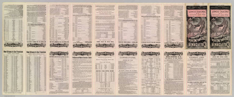
Author
Southern Pacific Company
Full Title
California, Texas, Mexico And Arizona Southern Pacific Co. "Sunset route" from New Orleans to the Pacific Coast ... January, 1892. American Bank Note Co., N.Y.
List No
3139B
Note
Timetables and travel information (20 p.) including self wrapper cover in color, illustrated. Folded to 21 x 10 cm.
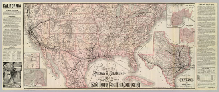
Author
Southern Pacific Company
Full Title
Correct map of the railway & steamship lines operated by the Southern Pacific Company [United States and Mexico]. Poole Bros., Map Engravers, Chicago. (inset) County map of Texas showing the Atlantic System of the Southern Pacific Company. (inset) San Francisco, California. (inset) Los Angeles, California. (inset) New Orleans. (inset) San Antonio, Texas.
List No
3139.001
Note
Col. map with 5 insets. Relief shown by hachures. Shows connecting steamship routes from New York to New Orleans. Text descriptions of California and Texas. Interior view of Sleeping Car.
Author
Atchison, Topeka, and Santa Fe Railroad Company
Full Title
(Covers to) Santa Fe Route. Official guide, main lines, branches and connections. Traffic Department, Topeka, Kansas. August, 1888. Rand, McNally & Co., Printers, Chicago.
List No
3342A
Note
Tan cardboard printed with above title against a dark blue and black background.
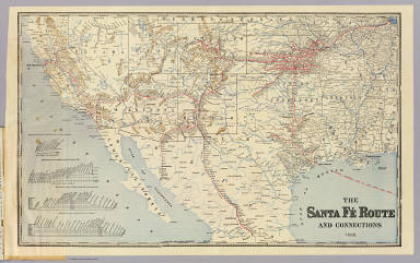
Author
Atchison, Topeka, and Santa Fe Railroad Company
Full Title
Santa Fe Route. Official guide, main lines, branches and connections. Traffic Department, Topeka, Kansas. August, 1888. Rand, McNally & Co., Printers, Chicago.
List No
3342.001
Note
Relief shown by hachures. Covers area from Chicago west and south to Veracruz. Profiles: Elevations between San Bernardino and Los Angeles -- Elevations between Barstow and National City -- Elevations between Kansas City and San Francisco -- Elevations between Kansas City and Mexico.
Author
Freyhold, Edward; Warren, Gouverneur Kemble, 1830-1882; United States. Army. Corps of Engineers
Full Title
Map of the Territory of the U.S. West of the Miss. Riv. Sheet no. 4. (Prepared by authority of the Hon. the Secretary of War in the Office of the Chief of Engineers under the direction of Brig. General A.A. Humphreys Chief of Engineers and Brevet Maj. Gen. U.S. Army. By Edward Freyhold 1879) (with) Territory of Alaska.
List No
3359.004
Note
Hand col. lithographed map. Relief shown by hachures and spot heights. Covers also part of Baja California. Alaska inset at scale (ca. 1:9,000,000).
Author
Freyhold, Edward; Warren, Gouverneur Kemble, 1830-1882; United States. Army. Corps of Engineers
Full Title
Map of the Territory of the U.S. West of the Miss. Riv. Sheet no. 5. (Prepared by authority of the Hon. the Secretary of War in the Office of the Chief of Engineers under the direction of Brig. General A.A. Humphreys Chief of Engineers and Brevet Maj. Gen. U.S. Army. By Edward Freyhold 1879)
List No
3359.005
Note
Hand col. lithographed map. Relief shown by hachures and spot heights. Covers also part of northern Mexico.
Author
Freyhold, Edward; Warren, Gouverneur Kemble, 1830-1882; United States. Army. Corps of Engineers
Full Title
Map of the Territory of the U.S. West of the Miss. Riv. Sheet no. 6. Prepared by authority of the Hon. the Secretary of War in the Office of the Chief of Engineers under the direction of Brig. General A.A. Humphreys Chief of Engineers and Brevet Maj. Gen. U.S. Army. By Edward Freyhold 1879.
List No
3359.006
Note
Photocopy of hand col. lithographed map. Relief shown by hachures and spot heights. Covers also part of northern Mexico.
Author
Duflot de Mofras, Eugene
Full Title
Carte De La Cote De L'Amerique Sur L'Ocean Pacifique Septentrional Le Territoire De L'Oregon, Les Californies, La Mer Vermeille, Partie des Territoires de la Compagnie de la Baie d'Hudson, Et De L'Amerique Russe. Dressee par Mr. Duflot de Mofras, Attache a la Legation de France a Mexico; Pour servir a l'intelligence de son Voyage d'exploration Publie Par Ordre Du Roi, sous les Auspices De Mr. Le Marechal Duc De Dalmatie, Mr. Le Ministre Des Affaires Etrangeres. Paris, 1844. Le plan grave par Jacobs. L'ecriture gravee par Hacq. Publie par Arthus Bertrand.
List No
4119.001
Note
Map in outline color with copious notes throughout California. Mines, ports, Indian settlements, forts, and missions are shown.
Author
Brue, Adrien Hubert, 1786-1832
Full Title
Carte encyprotype de l'Amerique Septentrionale, dediee et presentee a Monsieur. Par H. Brue, Ingenieur-Geographe de S.A. Royale. 1ere feuille. Dirige par H. Brue. A Paris, Chez Desray ... (et) J. Goujon ..., 1815.
List No
4614.035
Note
Engraved map. Outline hand col. Amerique Septentrionale 3e. feuille (SW sheet). Relief shown by hachures. Prime meridian: Paris. "Atlas universel no. (29)."
Author
Flemming, Carl
Full Title
Mexico, Mittel-America, Texas. Lithographie, Druck u. Verlag von C. Flemming in Glogau. (1855)
List No
4765.081
Note
Hand colored lithographed map. Relief shown by hachures. Prime meridian: Paris.
Author
Radefeld, Carl Christian Franz, 1788-1874
Full Title
Texas. Nach den besten Quellen entw. u. gez. vom Hauptm. Radefeld. 1846. Stich, Druck und Verlag des Bibliographischen Instituts zu Hildburghausen, (1860)
List No
4807.165
Note
Engraved map. State boundaries hand col. Relief shown by hachures. Covers the most of the southwestern U.S. and northern Mexico. "Meyer's Handatlas No. 103." Prime meridians: Greenwich, Paris, Washington and Ferro.
Author
Radefeld, Carl Christian Franz, 1788-1874
Full Title
Neueste Karte von Mexico. Nach den besten Quellen entw. u. gezeichn. von Hauptm. Radefeld. 1845. Stich, Druk, und Verlag des Bibliographischen Instituts zu Hildburghausen, (1860)
List No
4807.167
Note
Engraved map. State boundaries hand col. Relief shown by hachures. "Meyer's Handatlas No. 66." Prime meridians: Ferro and Paris.
Author
U.S. War Department, Topographical Engineers
Full Title
Map Of The United States And Their Territories Between The Mississippi and the Pacific Ocean And Of Part of Mexico. Compiled in the Bureau of the Corps of Topogl. Engs. under a Resolution of the U.S. Senate. From the best authorities which could be obtained. 1850. Engraved by Sherman and Smith, New-York.
List No
5142.000
Note
This was the best general map of the American West published by the Topographical Engineers until the Emory and Warren maps of 1857. Wheat calls it "beautiful... a synthesis of the many and varied cartographic activities of the U.S. Army carried on in the West since the onset of the Mexican War, with numerous individual maps subjected to correction and enhanced by new data." A large and imposing production, the map shows the new political divisions of California, Utah and New Mexico and is engraved in the best style by the well known Sherman and Smith firm of New York. Map is without color.
Author
Disturnell, John
Full Title
(Covers to) Mapa de los Estados Unidos de Mejico, segun lo organizado y definido por las varias actas del Congreso de dicha Republica ... Lo Publican J. Disturnell, 102 Broadway. Nueva York. 1846.
List No
5175A
Note
Red cloth covers 15x10 with "Mexico." stamped in gold.
|