|
Author
Stein, Christ. Gottfr. Dan.
Full Title
(Composite of) Vereinigte Staaten von NordAmerika, nebst Mexico und Centralamerika. (with) San Francisco und Umgegend. (with) Die deutsche Colonie Wartburg, Staat Tennessee. (with) Die nordostlichen Staaten der Union. (with) Eisenbahnverbindung zwischen Chagres und Panama. (with) Isthmus von Panama. (with New York Bay). (with) Plan von Boston. Entworfen von G. Heck, gestochen under s. Leitung. Gestochen von R. Schmidt, H. Eberhardt u. J.L. v. Baehr. J.C. Hinrichs'sche Buchhandlung, Leipzig. (1865)
List No
3134.025
Note
Digital composite of 2 hand colored maps. Relief shown by hachures. Shows populated places, Indian villages and missions, ports, railroads, canals, roads, etc. Prime meridians: Ferro and Greenwich. "Stein, Neuer Atlas der ganzen Erde."
Author
Southern Pacific Company
Full Title
(Covers to:) California, Texas, Mexico And Arizona Southern Pacific Co. "Sunset route" from New Orleans to the Pacific Coast ... January, 1892. American Bank Note Co., N.Y.
List No
3139A
Note
Self wrapper cover in color, illustrated.
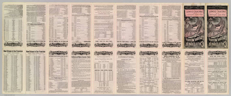
Author
Southern Pacific Company
Full Title
California, Texas, Mexico And Arizona Southern Pacific Co. "Sunset route" from New Orleans to the Pacific Coast ... January, 1892. American Bank Note Co., N.Y.
List No
3139B
Note
Timetables and travel information (20 p.) including self wrapper cover in color, illustrated. Folded to 21 x 10 cm.
Author
Southern Pacific Company
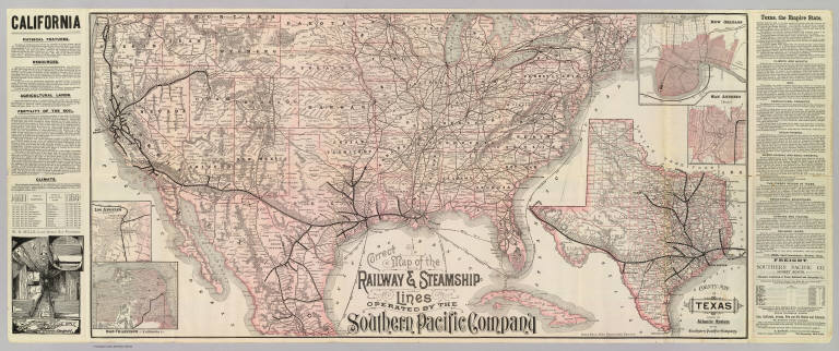
Full Title
Correct map of the railway & steamship lines operated by the Southern Pacific Company [United States and Mexico]. Poole Bros., Map Engravers, Chicago. (inset) County map of Texas showing the Atlantic System of the Southern Pacific Company. (inset) San Francisco, California. (inset) Los Angeles, California. (inset) New Orleans. (inset) San Antonio, Texas.
List No
3139.001
Note
Col. map with 5 insets. Relief shown by hachures. Shows connecting steamship routes from New York to New Orleans. Text descriptions of California and Texas. Interior view of Sleeping Car.
Author
U.S. General Land Office
Full Title
Map of the United States and territories, with adjacent parts of Canada and Mexico also part of the West India islands, showing the extent of public surveys, Indian, military, and forest reservations, rail roads, canals, national parks and other details, compiled from official surveys of the General Land Office and other authentic sources. Under the direction of the Hon. Lewis A. Groff, Commissioner. A.F. Dinsmore, Chief, Draughting Division. 1890. Isaac Friedenwald, Photo. Litho. Balto. Md. (inset) Territory of Alaska.
List No
3157.000
Note
Changes from 1888 ed: N. & S. Dakota, Oklahoma Ter., smaller Ind. Res. Printed in full color. Printed on 6 sheets (David Rumsey Collection copy mounted as one sheet). Relief shown by hachures. Prime meridians: Greenwich and Washington.
Author
Fenner, Rest.
Full Title
Mexico & Guatemala.
List No
3247.043
Author
[Drioux, Claude-Joseph, Leroy, Charles]
Full Title
Carte physique et politique : Amerique du Nord. Par M.Mrs. Drioux et Ch. Leroy. Dessine par A. Vilpou. Grave par L. Sonnet. Librairie Classique Eugene Belin Paris. (to accompany) Atlas Universel Et Classique De Geographie ...1886. (insets) Voyages de Christophe Colomb ; Mexique.
List No
3277.058
Note
Colored physical and political map of North America with 2 insets on 2 pages. Shows boundaries, regions, cities, roads, railroads, shipping lines, rivers, lakes, mountains, etc. Relief shown by hachures. Includes legend. European colonies in North America, list of the States, and routes and dates of Columbus voyages.
Author
[Drioux, Claude-Joseph, Leroy, Charles]
Full Title
Carte physique et politique des Etats - Unis : Canada et partie du Mexice. Par M.Mrs. Drioux et Ch. Leroy. Dessine par A. Vilpou. Grave par L. Sonnet. Librairie Classique Eugene Belin Paris. (to accompany) Atlas Universel Et Classique De Geographie ...1886. (insets) Etats - Unis (Etats di Nord-Est) ; Territoire d'Alaska.
List No
3277.059
Note
Colored physical and political map of United States, Canada and part of Mexico with 2 insets on 2 pages. Shows boundaries, regions, cities, roads, railroads, canals, rivers, lakes, mountains, etc. Relief shown by hachures.
Author
Johnston, Alexander Keith
Full Title
North America. By Keith Johnston, F.R.S.E. Keith Johnston's General Atlas. Engraved, Printed, and Published by W. & A.K. Johnston, Edinburgh & London.
List No
3287.050
Note
Countries and districts outlined in color. Relief shown by hachures. Four scales.
Author
Johnston, Alexander Keith
Full Title
Mexico. By Keith Johnston, F.R.S.E. Keith Johnston's General Atlas. Engraved, Printed, and Published by W. & A.K. Johnston, Edinburgh & London.
List No
3287.056
Note
Countries and provinces outlined in color. Relief shown by hachures. Three scales.
Author
Ensigns & Thayer
Full Title
Ornamental Map Of The United States & Mexico. Map Of The United States And Mexico. Published by Ensign, Thayer & Co., 50 Ann St., New York, And 127 Main St., Buffalo. Entered ... 1848, by Ensigns & Thayer ... New York. Sowle & Ward, 43 Cornhill, Boston.
List No
3292.000
Note
Same as the 1848 edition, but shows different states in the western U.S. Also eliminates the Table of Distances in Mexico. This map is mounted as a wall map. Blanchard's name is dropped. Date is estimated from the U.S. western states. Map is surrounded by drawings including pictures of Generals Taylor and Scott, a panoramic view from New York to the Pacific Ocean by the "contemplated Oregon railroad," the Great Temple destroyed by Cortez in 1521 and "The Halls of the Montezumas." With black top and bottom sticks. Full color by state or territory.
Author
Ferry, Julio Popper
Full Title
Plano del perimetro central, directorio comerical de la Ciudad de Mexico formado por Julio Popper Ferry. Al Senor Ministro De Gobernacion de los Estados Unidos Mexicanos, General Carlos Diez Gutierrez, testimonio de consideracion y respeto. En deposito: Litografia Debray Sucs., Mexico ... Propiedad Del Autor. Lit. Deray Sucs. Mexico. Ano 1o., 1ra. edicion.
List No
3302.000
Note
Shows businesses in the blocks just west of the Zocalo in Mexico City. Color litho. Folded into plain brown leather covers 18.5x12.
Author
[Dower, John, Teesdale, Henry]
Full Title
Mexico and Guatimala. Drawn & engraved by J. Dower. London, Published by Henry Teesdale & Co. (to accompany) A New General Atlas of the World, from Drawings made Expressly for this Work, By John Dower. (inset continuation of map) Florida.
List No
3326.040
Note
Outline hand color map of the United Statistical States, east of the Missouri River, with rivers extending westward through the Missouri Territory and Great Desert. Shows states boundaries, rivers and principal settlements. Relief shown by hachures. Prime meridian is Greenwich.
Author
Atchison, Topeka, and Santa Fe Railroad Company
Full Title
(Covers to) Santa Fe Route. Official guide, main lines, branches and connections. Traffic Department, Topeka, Kansas. August, 1888. Rand, McNally & Co., Printers, Chicago.
List No
3342A
Note
Tan cardboard printed with above title against a dark blue and black background.
Author
Atchison, Topeka, and Santa Fe Railroad Company
Full Title
Santa Fe Route. Official guide, main lines, branches and connections. Traffic Department, Topeka, Kansas. August, 1888. Rand, McNally & Co., Printers, Chicago.
List No
3342.001
Note
Relief shown by hachures. Covers area from Chicago west and south to Veracruz. Profiles: Elevations between San Bernardino and Los Angeles -- Elevations between Barstow and National City -- Elevations between Kansas City and San Francisco -- Elevations between Kansas City and Mexico.
Author
Rand McNally and Company
Full Title
(Covers to) Rand, McNally & Co's. general map of the Republic of Mexico constructed from the best authorities showing completed & proposed railways, steamship routes and telegraphic communications. Chicago, U.S. 1882. Rand, McNally & Co., Map Publisher and Engravers, Chicago, Ill. Copyrighted, 1882 by Rand, McNally & Co., Chicago, Ill.
List No
3347A
Note
Very large hand colored map with detailed engraving. This does not look like the "normal" Rand McNally map - it is probably a separately made map that they acquired the rights to. This copy was sold in England by Edward Stanford and has his label on the case. Map is in four sheets, each dissected into 21 sections. With outline color by state, topography shown in brown, and railways and shipping routes in red. Sheets have marbled end papers with labels reading "North East", "North West", "South East" and "South West"; all fold into a brown cloth slip case 22.5x14.5 with a label reading "Mexico. London: Edward Stanford, Wholesale & Retail Mapseller, &c. 55, Charing Cross. Agent by Appointment ..." Relief shown by shading. Prime meridians: Washington and Greenwich.
Author
Rand McNally and Company
Full Title
Rand, McNally & Co's. general map of the Republic of Mexico constructed from the best authorities showing completed & proposed railways, steamship routes and telegraphic communications. Chicago, U.S. 1882. Rand, McNally & Co., Map Publisher and Engravers, Chicago, Ill. Copyrighted, 1882 by Rand, McNally & Co., Chicago, Ill.
List No
3347.001
Note
Very large hand colored map with detailed engraving. This does not look like the "normal" Rand McNally map - it is probably a separately made map that they acquired the rights to. This copy was sold in England by Edward Stanford and has his label on the case. Map is in four sheets, each dissected into 21 sections. With outline color by state, topography shown in brown, and railways and shipping routes in red. Sheets have marbled end papers with labels reading "North East", "North West", "South East" and "South West"; all fold into a brown cloth slip case 22.5x14.5 with a label reading "Mexico. London: Edward Stanford, Wholesale & Retail Mapseller, &c. 55, Charing Cross. Agent by Appointment ..." Relief shown by shading. Prime meridians: Washington and Greenwich.
Author
Vancouver, George, 1757-1798
Full Title
A Chart shewing part of the Coast of N.W. America, With the Tracks of His Majesty's Sloop Discovery and Armed Tender Chatham; Commanded by George Vancouver Esqr. and prepared under his immediate inspection by Lieut. Joseph Baker, in which the Continental Shore has been traced and determined from Lat. 30¼00'N. and Long. 244¼32' E. to Lat. 38¼30'N and Long 237¼13'E. Engraved by T. Foot, Weston Place, Battle Bridge. No. 8. (with) Entrance of Port Sn. Francisco. (and) Port Sn. Diego. London: Published May 1st 1798, by J. Edwards Pall Mall & G. Robinson Paternoster Row.
List No
3354.008
Note
Map uncolored and shaded. Note in the title cartouche states, "The parts shaded Red are taken from Spanish Authorities." (No red shading has been added to this copy.) The vessels' tracks are shown by dotted lines. Spanish Missions and Presidios are noted. Map extends from St. Domingo, Mexico in the south to Point Reyes, California in the north.
Author
Vancouver, George, 1757-1798
Full Title
Views of Parts of the Coast of North West America. 9. W. Alexander delt. from Sketches made on the spot. London: Published May 1st 1798, by R. Edwards New Bond Street, J. Edwards Pall Mall and G. Robinson Paternoster Row. J. Fittler sculp.
List No
3354.009
Note
Uncolored views including Punto de los Reyes and the Bay of Sir Francis Drake, Port of St. Francisco, Point Pinos, Santa Barbara, the entrance to the Port of St. Diego, and Cape Colnett.
Author
[La Perouse, Jean-Francois de Galaup, comte de, 1741-1788, Pantoja y Arriaga, Juan]
Full Title
Plan du Port de St. Diego en Californie situe par 32039'0" de latitude nord et 1204'0" a l'ouest de St. Blas. Leve en 1782. Plan du Port de du Departement de St. Blas situe par 21 30' de latitude nd. et 88015' a l'ouest de Teneriffe et a 107015' a l'ouest de Paris. Leve en Novembre 1777. L. Aubert scripsit. Atlas du Voyage de la Perouse no. 35. (Paris: L'Imprimerie de la Republique, An V, 1797)
List No
3355.035
Note
Two engraved maps. Relief shown by hachures; depths by soundings.
Author
Freyhold, Edward; Warren, Gouverneur Kemble, 1830-1882; United States. Army. Corps of Engineers
Full Title
Map of the Territory of the U.S. West of the Miss. Riv. Sheet no. 4. (Prepared by authority of the Hon. the Secretary of War in the Office of the Chief of Engineers under the direction of Brig. General A.A. Humphreys Chief of Engineers and Brevet Maj. Gen. U.S. Army. By Edward Freyhold 1879) (with) Territory of Alaska.
List No
3359.004
Note
Hand col. lithographed map. Relief shown by hachures and spot heights. Covers also part of Baja California. Alaska inset at scale (ca. 1:9,000,000).
Author
Freyhold, Edward; Warren, Gouverneur Kemble, 1830-1882; United States. Army. Corps of Engineers
Full Title
Map of the Territory of the U.S. West of the Miss. Riv. Sheet no. 5. (Prepared by authority of the Hon. the Secretary of War in the Office of the Chief of Engineers under the direction of Brig. General A.A. Humphreys Chief of Engineers and Brevet Maj. Gen. U.S. Army. By Edward Freyhold 1879)
List No
3359.005
Note
Hand col. lithographed map. Relief shown by hachures and spot heights. Covers also part of northern Mexico.
Author
Freyhold, Edward; Warren, Gouverneur Kemble, 1830-1882; United States. Army. Corps of Engineers
Full Title
Map of the Territory of the U.S. West of the Miss. Riv. Sheet no. 6. Prepared by authority of the Hon. the Secretary of War in the Office of the Chief of Engineers under the direction of Brig. General A.A. Humphreys Chief of Engineers and Brevet Maj. Gen. U.S. Army. By Edward Freyhold 1879.
List No
3359.006
Note
Photocopy of hand col. lithographed map. Relief shown by hachures and spot heights. Covers also part of northern Mexico.
Author
Fenner, Rest.
Full Title
Mexico & Guatamala (sic). Fenner Sc., Paternoster Row. (London, Joseph Thomas, 1835)
List No
3362.064
Note
Engraved map. Outline hand coloring. Relief shown by hachures.
Author
Colton, G.W. & C.B.
Full Title
(Covers to) Colton's Map Of The United States Of America, The British Provinces, Mexico and the West Indies. Showing the Country from the Atlantic to the Pacific Ocean. Engraved, Printed & Published by G.W. & C.B. Colton & Co. New York. 1885. Entered ... 1884 by G.W. & C.B. Colton & Co. ... Washington.
List No
3443.001
Note
A very late edition of and reformatting of a Colton "standard" U.S. In two halves, unjoined. Entered in 1884, this is an entirely new map of the U.S., still using the title used since 1850. The hachuring is particularly detailed, probably influenced by Freyhold's map of 1879. A former owner has inked in some railroad routes in the west. Full color by state. Map is folded into dark brown cloth covers 20.5x10 stamped with "Colton's Map Of The United States. G.W. & C.B. Colton & Co., New York." in gilt.
Author
Colton, G.W. & C.B.
Full Title
Colton's Map Of The United States Of America, The British Provinces, Mexico and the West Indies. Showing the Country from the Atlantic to the Pacific Ocean. Engraved, Printed & Published by G.W. & C.B. Colton & Co. New York. 1885. Entered ... 1884 by G.W. & C.B. Colton & Co. ... Washington.
List No
3443.002
Note
A very late edition of and reformatting of a Colton "standard" U.S. In two halves, unjoined. Entered in 1884, this is an entirely new map of the U.S., still using the title used since 1850. The hachuring is particularly detailed, probably influenced by Freyhold's map of 1879. A former owner has inked in some railroad routes in the west. Full color by state. Map is folded into dark brown cloth covers 20.5x10 stamped with "Colton's Map Of The United States. G.W. & C.B. Colton & Co., New York." in gilt. Prime meridians are Greenwich and Washington D.C.
Author
Colton, G.W. & C.B.
Full Title
(Composite of) Colton's Map Of The United States Of America, The British Provinces, Mexico and the West Indies. Showing the Country from the Atlantic to the Pacific Ocean. Engraved, Printed & Published by G.W. & C.B. Colton & Co. New York. 1885. Entered ... 1884 by G.W. & C.B. Colton & Co. ... Washington.
List No
3443.003
Note
A very late edition of and reformatting of a Colton "standard" U.S. In two halves, unjoined. Entered in 1884, this is an entirely new map of the U.S., still using the title used since 1850. The hachuring is particularly detailed, probably influenced by Freyhold's map of 1879. A former owner has inked in some railroad routes in the west. Full color by state. Map is folded into dark brown cloth covers 20.5x10 stamped with "Colton's Map Of The United States. G.W. & C.B. Colton & Co., New York." in gilt. Prime meridians are Greenwich and Washington D.C.
Author
Smith, J. Calvin
Full Title
(United States, Mexico, Central America, Caribbean).
List No
3471.016
Note
Estimated Date. Part of a sixteen piece map combined digitally as a composite in final map of series.
Author
U.S. War Department, Topographical Engineers
Full Title
Siege Of Vera Cruz, by the U.S. Troops under Major General Scott, in March 1847, from Surveys made by Major Turnbull, Captains Hughes, McClellan & Johnston; Lieutenants Derby & Hardcastle, Topl. Engineers. Drawn by Capt. McClellan.
List No
3482.000
Note
Separately published map of an important Mexican War battle. Not in the large group of maps on the war published in Message of the President in the same year (see our copy). Hand colored outline map, Shows military fortifications, and roads. Relief shown by hachures.
Author
[Butterfield, Carlos, Johnson & Browning]
Full Title
United States and Mexican Mail Steamship Line, and Statistics of Mexico. By Carlos Butterfield, Washington. December, 1859. New York: J.A.H. Hasbrouck & Co., Printers ... 1860. (on verso) Entered ... 1859, by Carlos Butterfield ... New York. (With) Map of the United States and Mexico Published by Johnson & Browning under the direction of Col. Carlos Butterfield. December 1859.
List No
3484.001
Note
The map, 79x95, is from Johnson's 1857 Map of the Union, and becomes Colton's Map of the United States, Mexico, the West Indies etc. of 1861. The map shows all the interesting changes of 1859: Colona, Nevada, Arizona, Dakota, and an unnamed Idaho. Wheat says, "The map is a most important one for its showing of political subdivisions in the West, and for its tracing of the 'Mail Route,' on the route of the Butterfield Stageline." Its function here is to show the possible routes between the U.S. and Mexico by steamship. NUC lists an edition of 1859 at the Library of Congress. Sabin only lists this 1860 edition. A second edition was published in 1861 with a map of the United States by Julius Bien (see D. Sloan Bulletin Nine). Bound with brown cloth covered boards with title embossed on cover.
Author
[Butterfield, Carlos, Johnson & Browning]
Full Title
(Title page to) United States and Mexican Mail Steamship Line, and Statistics of Mexico. By Carlos Butterfield, Washington. December, 1859. New York: J.A.H. Hasbrouck & Co., Printers ... 1860. (on verso) Entered ... 1859, by Carlos Butterfield ... New York. (With) Map of the United States and Mexico Published by Johnson & Browning under the direction of Col. Carlos Butterfield. December 1859.
List No
3484.002
Note
The map, 79x95, is from Johnson's 1857 Map of the Union, and becomes Colton's Map of the United States, Mexico, the West Indies etc. of 1861. The map shows all the interesting changes of 1859: Colona, Nevada, Arizona, Dakota, and an unnamed Idaho. Wheat says, "The map is a most important one for its showing of political subdivisions in the West, and for its tracing of the 'Mail Route,' on the route of the Butterfield Stageline." Its function here is to show the possible routes between the U.S. and Mexico by steamship. NUC lists an edition of 1859 at the Library of Congress. Sabin only lists this 1860 edition. A second edition was published in 1861 with a map of the United States by Julius Bien (see D. Sloan Bulletin Nine). Bound with brown cloth covered boards with title embossed on cover.
Author
[Rand McNally and Company, Schlitz Brewing Company]
Full Title
(Covers to) Atlas Of The Mexican Conflict Containing Detailed Maps Showing the Territory Involved, Pertinent Statistics of Mexico and the United States, Summary of Recent Events in Mexico. Rand McNally & Company, Publishers, Chicago - New York, U.S.A. 1914. Copyright, 1914, by Rand, McNally & Co.
List No
3490A
Note
Covers are pale yellow paper with "Schlitz War Atlas. Drink Schlitz Trade Mark. The Beer That Made Milwaukee Famous" printed in red.
Author
[Rand McNally and Company, Schlitz Brewing Company]
Full Title
(Table of Contents to) Atlas Of The Mexican Conflict Containing Detailed Maps Showing the Territory Involved, Pertinent Statistics of Mexico and the United States, Summary of Recent Events in Mexico. Rand McNally & Company, Publishers, Chicago - New York, U.S.A. 1914. Copyright, 1914, by Rand, McNally & Co.
List No
3490B
Note
Table of Contents inside front cover. Red printing.
Author
[Rand McNally and Company, Schlitz Brewing Company]
Full Title
(Title Page to) Atlas Of The Mexican Conflict Containing Detailed Maps Showing the Territory Involved, Pertinent Statistics of Mexico and the United States, Summary of Recent Events in Mexico. Rand McNally & Company, Publishers, Chicago - New York, U.S.A. 1914. Copyright, 1914, by Rand, McNally & Co.
List No
3490C
Note
Small vignette of globe with Western Hemisphere.
Author
[Rand McNally and Company, Schlitz Brewing Company]
Full Title
Mexico. Copyright by Rand-McNally & Co. 1912.
List No
3490.004
Note
Full color. List of Mexican localities keyed to map location. Overprint in red shows distribution of American and Mexican fleets, locations of territories of Mexican rebel leaders, and forts. Inset of State of Mexico.
Author
Mitchell, Samuel Augustus
Full Title
Map of the United States. Engraved to illustrate Mitchell's school and family geography. (with) Map of Mexico and Guatimala engraved to illustrate Mitchell's school and family geography. Engraved by W. Williams. Entered ... 1839 by S. Augustus Mitchell ... Connecticut.
List No
3559.003
Note
Engraved map with inset. Hand colored. Relief shown by hachures. Shows railroads, canals, cities with population, Indian tribes, etc. Prime meridians: Greenwich and Washington.
Author
Rand McNally and Company
Full Title
Rand, McNally & Co. 's indexed atlas of the world map of Mexico. (with) Map of the Valley of Mexico on enlarged scale. Copyright, 1891 by Rand, McNally & Co. ... Engravers, Chicago, (1897)
List No
3565.054
Note
Col. map. Relief shown by hachures and spot heights. Scale of inset (ca. 1:410,000). Title in margin: Rand, McNally & Company's indexed atlas of the world.
Author
Magnus, Charles
Full Title
(Covers to) Map Of The United States of America, The British Provinces, Mexico, the West Indies and Central America. Published by Charles Magnus. New York. 1854. (inset map) Central America.
List No
3572.001
Note
1st edition was 1850; this issue is updated to show Washington Territory, but not Kansas and Nebraska. Wheat mentions the curious and inaccurate indentations on the California coastline. Wheat also states that the 1850 edition shows no towns in the Sierra Nevada - in this issue there are several towns shown. Full color by state. Includes table of distances. Relief shown by hachures. Prime meridian is Washington, D.C.
Author
Magnus, Charles
Full Title
Map Of The United States of America, The British Provinces, Mexico, the West Indies and Central America. Published by Charles Magnus. New York. 1854. (inset map) Central America.
List No
3572.000
Note
1st edition was 1850; this issue is updated to show Washington Territory, but not Kansas and Nebraska. Wheat mentions the curious and inaccurate indentations on the California coastline. Wheat also states that the 1850 edition shows no towns in the Sierra Nevada - in this issue there are several towns shown. Full color by state. Includes table of distances. Relief shown by hachures. Prime meridian is Washington, D.C.
Author
Mitchell, Samuel Augustus.
Full Title
Mexico & Geuatemala. Published By S. Augustus Mitchell, N.E. corner of Market & 7th Streets. Philada. 1848. Entered ... 1846, by H.N. Burroughs ... Pennsylvania. (to accompany) A New Universal Atlas Containing Maps of the various Empires, Kingdoms, States and Republics Of The World. (insets) Guatemala. (with) Valley of Mexico.
List No
3697.041
Note
Color copper lithograph map by state or region. Covers Upper or New California and extended to Texas and part of Louisiana. Shows boundaries, Native American settlements, capitals, important towns, mines, Battle fields, mountains and rivers. includes descriptive notes and explanations. Prime meridians are Greenwich and Washington. Relief shown by hachures.
Author
[Arrowsmith, John, Forbes, Alexander]
Full Title
The Coasts of Guatimala And Mexico, from Panama To Cape Mendocino: with the Principal Harbours in California. 1839. London, Smith Elder & Co. 1839. John Arrowsmith. (with 6 inset maps).
List No
3718.000
Note
A separate copy of the map published in Forbes' History of Upper and Lower California. It is a lithograph, taken from the engraved edition of the map that appears in the first edition of Forbes' book. At first we thought this must be from one of the two reprints done in 1919 and 1939, but it is not. Possibly Smith Elder put out a later edition with this lithographed map but left the date the same on the title page. However, we still think it is more modern than that - we will keep looking for the source. Inset maps are titled: Sketch of Port Bodega. Harbour of San Francisco. Sketch of Puerto de S. Diego. Sketch of Monterrey Harbour. Sketch of St. Barbara Harbour. Sketch of Port S. Gabriel, or S. Pedro. Map has outline color by country. Prime meridian is Greenwich.
Author
Bowen, Emanuel
Full Title
A new & accurate map of Mexico or New Spain together with California, New Mexico &c. Drawn from the best modern maps & charts & regulated by astronl. observns. By Eman: Bowen. (London: Printed for William Innys, Richard Ware, Aaron Ward, J. and P. Knapton, John Clarke, T. Longman and T. Shewell, Thomas Osborne, Henry Whitridge ... M.DCC.XLVII)
List No
3733.057
Note
Engraved map. Shows shoals, etc. Includes historical note on California and ornamental cartouche. Relief shown pictorially. Inset map: The Gallipago Islands : discovered & described by Capt. Cowley in 1684. Scale [ca. 1:5,000,000]
Author
[Barbie du Bocage, J.G., Dufour, Auguste-Henri (1798-1865)]
Full Title
Mexique. (inset) Guatemala.
List No
3771.034
Note
Stained on edge.
Author
Colton, G.W.
Full Title
(Text Page) The Republic of Mexico.
List No
3800.060
Author
Colton, G.W.
Full Title
(Text Page) The Republic of Mexico (continued).
List No
3800.062
Author
Colton, G.W.
Full Title
Colton's Mexico. (inset) Territory and Isthmus of Tehuantepec.
List No
3800.129
Author
Mitchell, Samuel Augustus
Full Title
Mexico & Guatemala. Published by Thomas, Cowperthwait & Co. No. 253 Market Street, Philadelphia. Entered ... 1850, by Thomas, Cowperthwait & Co. ... Pennsylvania. (with four inset maps) Valley of Mexico, Guatemala ..., The Isthmus of Tehuantepec ..., Isthmus of Nicaragua ...
List No
3803.042
Note
Full color map by country and state. Explanation note, showing capitals, mines, battle fields, etc. Relief shown by hachures. Prime meridian is Washington, D.C.
Author
Mitchell, Samuel Augustus Jr.
Full Title
Map of Mexico, Central America and the West Indies. Entered ... 1874, by S. Augustus Mitchell ... Washington. (with 4 insets) Map of the Island of Jamaica; Map of the Sandwich Islands. Discovered by Captn. Cook in 1778; Map of the Bermuda Islands; Map of the Panama railroad.
List No
3804.049
Note
Hand colored map. Shows settlements, railroads, rivers, etc. Relief shown by hachures. Prime meridian is Greenwich.
Author
[Johnston, Alexander Keith, 1804-1871, Rogers, Henry Darwin]
Full Title
Mexico, North-western States. By Prof. H.D. Rogers & A. Keith Johnston, F.R.S.E. Entered in Sta. Hall. London ... & according to an act of Congress ... 1857, by H.D. Rogers ... Massachusetts. London, John Murray, Albemarle Street, Edinburgh, W. & A.K. Johnston. Engraved by W. & A.K. Johnston, Edinburgh.
List No
3825.020
Note
Baja California and the Northwestern part of Mexico shown in pink outline color.
Author
[Johnston, Alexander Keith, 1804-1871, Rogers, Henry Darwin]
Full Title
Mexico. North-eastern & Central States. By Prof. H.D. Rogers & A. Keith Johnston, F.R.S.E. Entered in Sta. Hall. London ... & according to an act of Congress ... 1857, by H.D. Rogers ... Massachusetts. London, John Murray, Albemarle Street, Edinburgh, W. & A.K. Johnston. Engraved by W. & A.K. Johnston, Edinburgh.
List No
3825.021
Note
Area shown in printed outline color.
|