|
Author
[Sartine, Antoine, Depot de la Marine]
Full Title
Carte Particulière du Havre de Boston
List No
15933.018
Author
United States. Post Office Department
Full Title
Post Route Map of the States of Massachusetts, Rhode Island and Connecticut.
List No
15924.002
Author
[Guyer, Terry, BioSpace, Synergistic Designs Inc, Fusionscape]
Full Title
Genetown
List No
15304.000
Author
Blaeu, Joan, 1596-1673
Full Title
Nova Belgica Et Anglia Nova
List No
15664.024
Note
20 Milliaria Germanica communia = 4.6 cm
Author
[Fisher, Joseph R., Planters Peanuts (Firm)]
Full Title
New Hampshire : The granite state -- Massachusetts : The bay state.
List No
14374.003
Note
Two views, representing New Hampshire and Massachusetts. Views show examples of the landscape and natural resources. Each view includes an inset map of the state, which marks the location of the capital city with a star. Accompanied by descriptive text, the state flags, seals and flowers: purple lilac and mayflower, respectively. The view of each state appears both in color (on top) and in black and white (bottom), the latter inviting coloration. Together, views are 18 x 26 cm, on sheet 20 x 27 cm.
Author
[City Graphics of America, International Data Corporation]
Full Title
Massachusetts Technology. Complements of IDC : International Data Corporation. 1984 City Graphics of America Inc. P.O.Box 261 Fremont , Ca.
List No
11433.000
Note
Colorful bird's-eye style pictorial map of Massachusetts by International Data Corp. Annotated throughout. Includes numerous individual vignettes of buildings, landmarks, place names, streets, parks, bridges, and businesses. Shows roads and highways.
Author
City Graphics of America
Full Title
Massachusetts Technology.
List No
10622.000
Author
[Bates, Ernest Sutherland, 1879-1939, Schiff, Herman S., Reeves, Norman, Smith, Robert E.]
Full Title
Massachusetts, 1629.
List No
14244.013
Note
Pictorial map of Massachusetts, showing political boundaries with bordering states and coastline. Features significant sites both natural (Berkshires) and manmade (Bunker Hill), as well as natural resources and manufactured items (including oysters, cranberries, tobacco and sewing machines). Includes a compass rose and a scroll listing notable places - such as Plymouth Rock - which are pictured in vignettes below map, in order of listing. Map is 17 x 29 cm, on sheet 23 x 29 cm. Accompanied by historical text on facing page.
Author
Clason Map Company
Full Title
Clason's Road Map of Massachusetts, Connecticut, Rhode Island. Showing paved roads, All weather roads and other throughfares. (U.S. Highways shown in red.) Published by the Clason Map Co., Denver. Copyrighted Clason Map. All rights reserved. Map No. R-218A. (inset) Interest map of Boston and vicinity.
List No
4423.010
Note
Color map with inset. Includes road legend, and Index of cities and towns giving 1930 census populations and Key to map.
Author
Tripp, B. Ashburton, 1887-1955
Full Title
Martha's Vineyard : Dukes County, Massachusetts. (Copyright) B. Ashburton Tripp. D&B. Published by B. Ashburton Tripp: Alexandria, Virginia. First Edition.
List No
8256.000
Note
Detailed uncolored pictorial map showing the Island of Martha's Vineyard in center. Relief shown pictorially. Includes towns, roads, lighthouses, forests and waterways. Surrounded by sketches of naval boats and fantasy portraits of the four winds in each corner. Vignettes bordering the map showing maritime scenes in each corner, churches and lighthouses. An inscription borders the entire scene. Inscription along bottom margin reads, ""This is the goodliest land we ever saw for it is replenished with fair fields and in them fragrant flowers."" Inscription along side and top margins reads, "We stood awhile like men ravished at the beautie and delicacie of the sweet soile; for besides rivers clear lakes of fresh water we saw meadows very large and hedged with stately groves - There was such an incredible store of vines we could not go for treading on them.' The Voyage of Bartholomew Gosnold - 1602." Signed and dated in ink at the bottom right, B. Ashburton Tripp, '54. Tripp died the next year, 1955, so we presume this was his last map.
Author
Tripp, B. Ashburton, 1887-1955
Full Title
Cape Cod : Barnstable County Massachusetts. Designed & copyrighted 1931, B. Ashburton Tripp - Cleveland, O. Ashburton Tripp ... Publisher ... Cleveland, Ohio.
List No
8636.000
Note
Hand colored by B. Ashburton Tripp. Tripp usually produced uncolored copies of this map in strong black and white tones, but he personaly colored a few copies, as in this copy from his archive. Early pictorial map of Cape Cod, with decorative title cartouche and large compass rose. Shows towns, roads, railroad, and rivers. Bordered by illustrations of Cape Cod scenes.
Author
Tripp, B. Ashburton, 1887-1955
Full Title
Cape Cod : Barnstable County Massachusetts.
List No
8637.000
Note
An unfinished map drawing of Cape Cod that must have been an early state of Tripp's final Map of Cape Cod (see our 8636.000 and 8173.000). It is at a slightly larger scale than the final published map and shows many of the scenes sketched out and some parts unfinished. Shows towns, roads, railroad, and rivers. Bordered by illustrations of Cape Cod scenes.
Author
Tripp, B. Ashburton, 1887-1955
Full Title
Cape Cod : Barnstable County Massachusetts.
List No
8644.000
Note
A completed map drawing of Cape Cod that must have been a study of sorts for of Tripp's final Map of Cape Cod (see our 8636.000 and 8173.000). It is at a slightly larger scale than the final published map. Like the unfinished drawing map (see our 8637.000), many of the views are only roughly sketched in. Shows towns, roads, railroad, and rivers. Bordered by illustrations of Cape Cod scenes.
Author
[Walker, G.H., Walker, O.W.]
Full Title
(Composite Map) (Massachusetts).
List No
2006.065
Author
Carleton, Osgood
Full Title
(Covers to) Map Of Massachusetts Proper Compiled from Actual Surveys, made by Order of the General Court, and under the inspection of Agents of their appointment, By Osgood Carleton. Engraved by Joseph Callender and Samuel Hill, Boston, 1801. Vignette Drawn by G. Graham.
List No
2258A
Author
Carleton, Osgood
Full Title
Map Of Massachusetts Proper Compiled from Actual Surveys, made by Order of the General Court, and under the inspection of Agents of their appointment, By Osgood Carleton. Engraved by Joseph Callender and Samuel Hill, Boston, 1801. Vignette Drawn by G. Graham.
List No
2258.001
Note
Engraved by Joseph Callender and Samuel Hill. Second map of Massachusetts by Carleton (1st was 1798), reengraved from the plates of the first issue, and the first official state map (the first edition was rejected by the legislature). With outline and full color. Map is dissected into 32 sections and mounted on linen. Folds into original black cardboard slip case 21x16 with a red leather label on the spine reading "Map Of Mass." in gilt.
Author
Appleton, D. & Co.
Full Title
Map of Massachusetts. Copyright 1891 by Matthews-Northrup Co. ... Buffalo, New York. (insets) Map of the vicinity of Boston; Map of Boston. (to accompany) The Library Atlas Of Modern Geography ... New York, D. Appleton And Company 1892. (on upper margin) Massachusetts. 70.
List No
0026.184
Note
Color map. Shows county boundaries and county seat, capital, railways, roads, etc. "Size of type indicates importance of the places". Includes notes. Relief shown by hachures. Prime meridians are Greenwich and Washington.
Author
Appleton, D. & Co.
Full Title
Map of Boston, Mass. Copyright 1891 by Matthews-Northrup Co. ... Buffalo, New York. (to accompany) The Library Atlas Of Modern Geography ... New York, D. Appleton And Company 1892. (on upper margin) Boston. 71.
List No
0026.187
Note
Color plan of Boston. Shows railways, street car lines, parks, canals, etc. Includes numerical references to Depots, hotels, churches, major buildings, and points of interest.
Author
Arbuckle Bros.
Full Title
Massachusetts, Vermont, Kentucky, New Jersey. Copyright 1889 Arbuckle Bros. N.Y.
List No
0027.002
Note
Sheet with maps of four states in full color. The card for Massachusetts notes that it is the leading state in its manufacture of paper and leather. Vermont is noted for being "extremely healthy" with "miasmatic diseases...totally unknown." Each card measures 7.5 x 12.5 cm.
Author
Lewis, Samuel
Full Title
Massachusetts. Drawn by S. Lewis. (Boston: Published by Thomas & Andrews. 1812)
List No
0028.032
Note
Engraved map, uncolored. Relief shown by hachures. Prime meridians: London and Philadelphia.
Author
[Bartholomew, John, Black, Adam & Charles]
Full Title
New York, Vermont, New Hampshire, Rhode Island, Massachusetts & Connecticut. Published by A. & C. Black. Edinburgh. Printed in Colours by Schenck & Macfariane. Edinburgh. Drawn & Engraved by J. Bartholomew, Edinburgh.
List No
0073.005
Note
States outlined in color. Land tinted. Inset of New York City.
Author
Borden, Simeon
Full Title
Topographical Map Of Massachusetts, Compiled From Astronomical, Trigonometrical, and Various Local Surveys Made By Order Of The Legislature. Simeon Borden, Superintendent. 1844. Engraved by George G. Smith, Boston. Entered ... 1844, by the Commonwealth of Massachusetts ... Massachusetts. Published & Sold by C. Hickling, No. 20 Devonshire St. Boston. (inset) Geological Map Of Massachusetts, Made By Order Of The Legislature, by Edward Hitchcock. 1844.
List No
0085.000
Note
Sponsored by the State Legislature as a replacement for Osgood Carlton's map. Based on maps produced by cities and towns during the 1830's (many of which were engraved by Pendleton and others - see our copies. A later edition was published by Walling in 1861. Geological inset map of the state by Edward Hitchcock. With black top and bottom sticks. Map with washed out outline color; inset in full color.
Author
Bradford, Thomas G.
Full Title
Massachusetts. Entered ... 1838, by T.G. Bradford ... Massachusetts. Engraved by G.W. Boynton.
List No
0089.010
Note
Map in full color by county.
Author
Bradford, Thomas G.
Full Title
Boston. Engraved by G.W. Boynton.
List No
0089.011
Note
Map in full color. Scale given in rods with the length of a rod being 16.5 feet.
Full Title
Carte geographique, statistique et historique de Massachusetts. Massachusetts. Fonderie et Imprimerie de J. Carez. (1825)
List No
0102.012
Note
Hand colored engraved map. Relief shown by hachures. Text and tables at sides and bottom. Prime meridians: Washington and Paris.
Author
[Carey, H. C., Lea, I.]
Full Title
Geographical, Historical, And Statistical Map Of Massachusetts. Massachusetts. No. 12. Drawn by F. Lucas. J. Yeager Sculp.
List No
0122.007
Note
In full color by county surrounded by text.
Author
Colton, G.W.
Full Title
Massachusetts And Rhode Island. (with) Vicinity of Boston. Published by J.H. Colton & Co. 172 William St. New York. Entered ... 1855 by J.H. Colton & Co. ... New York. No. 12.
List No
0149.020
Note
In full color.
Author
Colton, G.W.
Full Title
Map Of Boston And Adjacent Cities. Published by J.H. Colton & Co. 172 William St. New York. Entered ... 1855 by J.H. Colton & Co. ... New York. No. 13.
List No
0149.021
Note
In full color. Areas in the Boston Harbor and the Mill Dam are sketched in with roads and open space.
Author
Colton, G.W.
Full Title
Colton's Massachusetts and Rhode Island. (inset) Vicinity of Boston. Published By J. H. Colton. No. 172 William St. New York.
List No
0151.027
Note
Prime meridians are Greenwich and Washington D. C. Map showing the county boundaries in color.
Author
Colton, G.W.
Full Title
Colton's Massachusetts, Connecticut and Rhode Island. Published by G. W & C. B. Colton & Co., No. 172 William St. New York.
List No
0152.027
Note
Prime meridians are Washington D.C. and Greenwich.
Author
Colton, G.W.
Full Title
Colton's Boston and Adjacent Cities. Published by G. W & C. B. Colton & Co., No. 172 William St. New York.
List No
0152.028
Author
Cornell, S. S. (Sarah S.)
Full Title
Principal cities of the United States. Entered ... 1856, by S.S. Cornell ... Southern District of New York. Geo. Rae Smith, engraver, N.Y. New York: D. Appleton & Co., 443 & 445 Broadway. (1864)
List No
0197.005
Note
Seventeen engraved maps on 1 sheet. Contents: New York City and vicinity -- Portland -- Portsmouth -- Boston -- Providence -- Philadelphia -- Baltimore -- Washington City -- Charleston -- Savannah -- St. Louis -- Mobile -- New Orleans -- Chicago -- Cincinnati -- Detroit -- Buffalo & Niagara River. "Reference map."
Author
Cram, George Franklin
Full Title
Massachusetts, Rhode Island, & Connecticut.
List No
0210.025
Note
Prime meridians Greenwich and Washington.
Author
DeSilver, Robert
Full Title
(Covers to) The State of Massachusetts.
List No
0240.001
Note
Reissue of M. Carey 1818 edition General Atlas. Map is folded into red stamped card covers 13x7 with "Massachusets" misspelled in gilt. This is the same coloring and watermark as the six DeSilver maps issued as separates (see Pennsylvania). No changes from the 1818 Carey plate.
Author
DeSilver, Robert
Full Title
The State of Massachusetts.
List No
0240.002
Note
Outline color map. Relief shown by hachures. Prime meridians are Philadelphia and London.
Author
Dutton, E.P.
Full Title
(Covers to) New Map Of Massachusetts Compiled from The latest and best Authorities. Published At The Boston Map Store, E.P. Dutton & Co. 135 Washington Street, Boston, 1866. Entered ... 1863 by E.P Dutton & Co ... Massachusetts. (inset) Salem. (inset) Springfield. (inset) Worchester. (inset) Lowell. (inset) Boston.
List No
0253.001
Note
Catalogue of Boston Map Store inside front cover. Folded into dark green cloth covers 14.5x9 with "E.P Dutton & Co's. Map Of Massachusetts With Railroads & Townships." in gilt. (inset)Table of Distance.
Author
Dutton, E.P.
Full Title
New Map Of Massachusetts Compiled from The latest and best Authorities. Published At The Boston Map Store, E.P. Dutton & Co. 135 Washington Street, Boston, 1866. Entered ... 1863 by E.P Dutton & Co ... Massachusetts. (inset) Salem. (inset) Springfield. (inset) Worchester. (inset) Lowell. (inset) Boston.
List No
0253.002
Note
Catalogue of Boston Map Store inside front cover. Folded into dark green cloth covers 14.5x9 with "E.P Dutton & Co's. Map Of Massachusetts With Railroads & Townships." in gilt. (inset) Table of Distance.
Author
Finley, Anthony
Full Title
Map of Massachusetts Connecticut And Rhode Island Constructed from the Latest Authorities. 1825. Drawn by D.H. Vance. Engraved by J.H. Young. Published by A. Finley Philada. 1825.
List No
0278.004
Note
In full color by county. Statistical table compares the populations of the counties in 1810 and 1820. Square mileage for each state included.
Author
Finley, Anthony
Full Title
Map of Massachusetts, Connecticut, and Rhode Island, Constructed from the Latest Authorities.
List No
0279.008
Note
Date estimated.
Author
Finley, Anthony
Full Title
Map of Massachusetts, Connecticut, and Rhode Island Constructed from the Latest Authorities. Drawn by D.H. Vance. Published by A. Finley, Philada. Engraved by J.H. Young.
List No
0280.004
Note
Relief shown by hachures. Prime meridian Washington. Statistical table for each state.
Author
Finley, Anthony
Full Title
Massachusetts. Young & Delleker Sc. Published by A. Finley, Philada. (to accompany) A New General Atlas Comprising a Complete Set of Maps, representing the Grand Divisions Of The Globe ... Philadelphia: Published by Anthony Finley. 1827.
List No
0282.014
Note
Full color map on sheet 35x27. Relief shown pictorially. Prime meridians are Washington and Greenwich. Shows counties, major cities, roads and rivers.
Author
Finley, Anthony
Full Title
Massachusetts. Published by A. Finley Philada. Young & Delleker Sc. (inset) Map Of The Country in the vicinity of Boston.
List No
0285.010
Note
Full color by county.
Author
[Bowen, Emanuel, Gibson, John]
Full Title
New England. (to accompany) Atlas Minimus or a New Set of Pocket Maps of the Several Empires, Kingdoms and States of the Known World, with Historical Extracts relative to each. Drawn and Engraved by J. Gibson from the Best Authorities, Revis'd, Corrected and Improv'd by Eman: Bowen Geographer to His Majesty.
List No
0300.044
Note
First edition. The "Historical Extracts" are short bits of text printed on the maps giving relevant geographical information. A revised edition was published in London in 1792. In 1759, another edition was published adding separate geographical descriptions and correcting some of the maps (see our copy). The Philadelphia 1798 edition by Mathew Carey incorporates the 1759 edition text word for word (excepting the maps of United States which Carey omits in favor of his pocket atlas of the U.S.). Gibson and Bowen made the four sheet map of North America (Stevens 49), and Gibson made the four sheet map of America (Stevens 3).
Author
Gray, O.W.
Full Title
Gray's Atlas Map of Massachusetts and Rhode Island. (inset) Vicinity of Boston.
List No
0310.038
Author
[Gray, Frank A., Gray, O.W.]
Full Title
Gray's New Map of Massachusetts, Rhode Island, and Connecticut by Frank A. Gray. Copyright 1876 by O.W. Gray & Son. (inset) Boston.
List No
0312.012
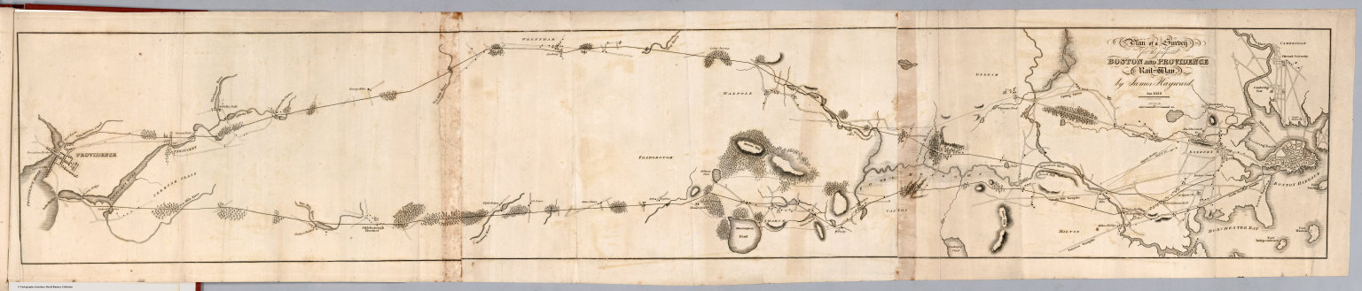
Author
Hayward, James
Full Title
Plan of a survey for the proposed Boston and Providence rail way. By James Hayward. Jan. 1828. (engraved by) Annin & Smith. (to accompany) Report of the Board of Commissioners, of Internal Improvement in Relation to the Examination of Sundry Routes for a Railway from Boston to Providence.
List No
0324.006
Note
Map is uncolored. Shows 2 possible routes between Boston and Providence. Relief shown by hachures.
Author
Jefferys, Thomas
Full Title
A Map of the most Inhabited part of New England, containing the Provinces of Massachusetts Bay and New Hampshire, with the Colonies of Conecticut And Rhode Island, Divided into Counties and Townships: The Whole composed from Actual Surveys and its Situation adjusted by Astronomical Observations. (with) A Plan of the Town of Boston. November 29th 1774. Published according to Act by Thos. Jefferys Geographer to His Royal highness the Prince of Wales near Charing Cross. (Northern section)
List No
0346.017
Note
Northern part of map in two sheets. In outline color except for section to the west of the Connecticut River, which is in yellow.
Author
Jefferys, Thomas
Full Title
A Map of the most Inhabited part of New England, containing the Provinces of Massachusetts Bay and New Hampshire, with the Colonies of Conecticut And Rhode Island, Divided into Counties and Townships: The Whole composed from Actual Surveys and its Situation adjusted by Astronomical Observations. (with) A Plan of Boston Harbor from an Accurate Survey. November 29th 1774. Published according to Act by Thos. Jefferys Geographer to His Royal highness the Prince of Wales near Charing Cross. (Southern section)
List No
0346.018
Note
Southern part of map in two sheets. In outline color. Cartouche includes large drawing of the pilgrims landing at Plymouth Rock.
Author
Johnson, A.J.
Full Title
Johnson's Vermont, New Hampshire, Massachusetts, Rhode Island, and Connecticut. Published by Johnson and Ward. Entered ... 1864, by A.J. Johnson ... New York.
List No
0352.019
Note
Full color with heavy outlines around counties and states. Prime meridians are Greenwich and Washington D.C. Relief shown by hachures. Includes explanatory keys.
Author
Johnson, A.J.
Full Title
Johnson's Massachusetts, Connecticut, And Rhode Island, Published By Johnson and Ward. "The City of Boston, Chelsea, North Chelsea, Winthrop, and Adjacent Islands, form the County of Suffolk."
List No
0352.020
Note
Full color with heavy outlines around counties and states. Prime meridians are Greenwich and Washington D.C. Relief shown by hachures.
Author
Johnson, A.J.
Full Title
Johnson's Massachusetts, Connecticut and Rhode Island. Entered ... 1864. (inset) Boston.
List No
0358.024
Author
Leahy, J.F.
Full Title
(Index to) Leahy's Hotel Guide and Railway Distance Maps. Massachusetts.
List No
0425.054
Note
Alphabetical index list of the Hotels of the town with the number of rooms of each, their rates per day and the population of the town. Includes population of the states, Explanation of abbreviation of the railroad of the state, and advertisements.
Author
Leahy, J.F.
Full Title
Leahy's Hotel Guide and Railway Distance Map of the State of Masschusetts. Published by American Hotel Register Company. Leahy Build., 228-234 W. Ontario St., Chicago, Ill. Copyrighted by J.F. Leahy, Jan., 1934.
List No
0425.055
Note
Map printed without color. Includes name of the railroad entering the town, and distance between towns.
Author
Leahy, J.F.
Full Title
(Index to) Leahy's Hotel Guide and Railway Distance Maps. Massachusetts. Rhode Island.
List No
0425.056
Note
Continuation alphabetical index list of the Hotels of the town with the number of rooms of each, their rates per day and the population of the town in Massachusetts and alphabetical index list of Hotels ... in Rhode Island. Includes population of the states, Explanation of abbreviation of the railroad of the state, and advertisements.
Author
Leahy, J.F.
Full Title
Leahy's Hotel Guide and Railway Distance Map of the State of Rhode Island. Published by American Hotel Register Company. Leahy Build., 228-234 W. Ontario St., Chicago, Ill. Copyrighted by J.F. Leahy, Jan., 1934.
List No
0425.057
Note
Map printed without color. Includes name of the railroad entering the town, and distance between towns.
Author
Marshall, John
Full Title
Carte des Provinces Septles. des Etats-Unis. (1807)
List No
0462.001
Note
Fold-out map. Relief shown by sketches. Meridian Paris. Engraved.
Author
Marshall, John
Full Title
Boston et Ses Environs. (1807)
List No
0462.004
Note
Folded map. Relief shown by hachures. Vegetation and structures shown. Engraved.
Author
Johnson, A.J.
Full Title
Johnson's Vermont, New Hampshire, Massachusetts, Rhode Island, and Connecticut.
List No
0535.018
Note
In full color with heavy outlines around counties and states. Meridians Greenwich and Washington D.C. Relief shown by hachures.
Author
Johnson, A.J.
Full Title
Johnson's Massachusetts, Connecticut, And Rhode Island, Published By Johnson and Ward. (inset) Vicinity of Boston.
List No
0535.019
Note
In full color with heavy color delineating states. Meridians Greenwich and Washington D.C. Relief shown by hachures.
Author
[Mitchell, Samuel Augustus, Tanner, Henry S.]
Full Title
Massachusetts and Rhode Island: by H.S. Tanner. (with) Boston. Published by S. Augustus Mitchell, N.E. corner of Market & 7th sts., Philada., 1846. Entered ... 1841 by H.S. Tanner ... Pennsylvania.
List No
0536.004
Note
Map printed in color -- outline color by county, in red and blue ink -- rather than the more normal (for this period) hand color. Relief shown by hachures. Shows settlements, roads, canals, railroads, etc. Prime meridian: Washington. Scale of Boston map ca. 1:26,000.
Author
Mitchell, Samuel Augustus
Full Title
Massachusetts And Rhode Island: (with) Boston. Published By S. Augustus Mitchell, N.E. corner of Market & 7th Street Philada., 1846. Entered ... 1846 by H.N. Burroughs ... Pennsylvania.
List No
0537.009
Note
In full color by county with population noted.
Author
Mitchell, Samuel Augustus
Full Title
Massachusetts & Rhode Island: Published By S. Augustus Mitchell. N.E. corner of Market & 7th. Streets. Philadelphia. (inset map) Boston.
List No
0545.012
Note
Outline and full color map, tinted by county. Explanation table shows symbols to railroads, canals, and county towns. Statistical tables showing population in both states. Prime meridian is Washington. Relief shown by hachures.
Author
Mitchell, Samuel Augustus
Full Title
Plan Of Boston. 17. (with) inset Map Of The Country around Boston Showing also its Harbor & Islands. 18. Entered ... 1860, by S. Augustus Mitchell, Jr. ... Pennsylvania.
List No
0565.011
Author
Mitchell, Samuel Augustus Jr.
Full Title
County map of Massachusetts, Connecticut, and Rhode Island. Drawn & Engraved by W.H. Gamble Philad. Entered ... 1862 by S. Augustus Mitchell, Jr. ... Pennsylvania.
List No
0572.015
Note
Full color map by county. Relief shown by hachures. Prime meridians are Greenwich and Washington, D.C.
Author
Mitchell, Samuel Augustus Jr.
Full Title
County map of Massachusetts, Connecticut, and Rhode Island. Drawn & Eng'd. by W.H. Gamble. Entered ... 1867 by S. Augustus Mitchell, Jr. ... Pennsylvania.
List No
0579.015
Note
Color map by State and county. Relief shown by hachures. Prime meridians are Greenwich and Washington, D.C.
Author
Mitchell, Samuel Augustus Jr.
Full Title
Plan of Boston. (inset map) 17. Map of the country around Boston showing also its Harbor & Islands. Entered ... 1867 by S. Augustus Mitchell, Jr. ... Pennsylvania.
List No
0579.016
Note
Color map. Showing roads, railroads, public buildings, etc.
Author
Mitchell, Samuel Augustus
Full Title
County and township map of the states of Massachusetts, Connecticut and Rhode Island. Drawn and engraved by W.H. Gamble, Philadelphia. Entered ... 1879 by S. Augustus Mitchell ... Washington. (1880)
List No
0586.013
Note
Hand colored. Relief shown by hachures. Shows settlements, railroads, rivers, etc. Prime meridians: Greenwich and Washington.
Author
Mitchell, Samuel Augustus
Full Title
Plan of Boston. (with) Map of the country around Boston showing also its harbor and islands. Entered ... 1879 by S. Augustus Mitchell ... Washington. (1880)
List No
0586.014
Note
Hand colored map with inset. Shows wards, major buildings, railroads, ferries, etc.
Author
Mitchell, Samuel Augustus Jr.
Full Title
County and township map of the states of Massachusetts, Connecticut and Rhode Island. Drawn and engraved by W.H. Gamble, Philadelphia. Copyright by S. Augustus Mitchell 1884.
List No
0592.014
Note
Hand colored. Relief shown by hachures. Shows settlements, railroads, rivers, etc. Prime meridians: Greenwich and Washington.
Author
Mitchell, Samuel Augustus Jr.
Full Title
Plan of Boston. (with) Map of the country around Boston showing also its harbor & islands. Copyright by S. Augustus Mitchell 1884.
List No
0592.015
Note
Hand colored map with inset. Shows wards, major buildings, railroads, ferries, etc.
Full Title
County and township map of the states of Massachusetts, Connecticut and Rhode Island. Drawn and engraved by W.H. Gamble, Philadelphia. Copyright 1887 by Wm. M. Bradley & Bro. (1890)
List No
0594.013
Note
Hand colored. Relief shown by hachures. Shows settlements, railroads, rivers, etc. Prime meridians: Greenwich and Washington.
Full Title
Plan of Boston. (with) Map of the country around Boston showing also its harbor & islands. Copyright 1887 by Wm. M. Bradley & Bro. (1890)
List No
0594.014
Note
Hand colored map with inset. Shows wards, major buildings, railroads, ferries, etc.
Author
[Morse, Charles W., Colby, Charles A.]
Full Title
Massachusetts and Rhode Island.
List No
0623.016
Author
Morse, Jedidiah
Full Title
A Map of Massachusetts from the best Authorities. I. Mutlow Sc. 6 James St. Covt. Gardn. Published July 8, 1794 by I. Stockdale, Piccadilly.
List No
0632.008
Note
Without color.
Author
Morse, Sidney E. (Sidney Edwards), 1794-1871
Full Title
(Covers to) Massachusetts, Rhode-Island And Connecticut. On the Improved Plan of Sidney E. Morse, A.M. Entered ... second day of May, 1827, By Sidney E. Morse ... Connecticut. Published by N. & S.S. Jocelyn, New-Haven, Con. 1827. N. & S.S. Jocelyn Sc. (inset) Boston and its Vicinity.
List No
0639.001
Note
From Atlas of the U.S., 1823. Index sheet joined. This is very early for an indexed map in pocket form; folded into red stamped paper covers 10x6.5 with "Mass. R.I. & Con." in gilt.
Author
Morse, Sidney E. (Sidney Edwards), 1794-1871
Full Title
Massachusetts, Rhode-Island And Connecticut. On the Improved Plan of Sidney E. Morse, A.M. Entered ... second day of May, 1827, By Sidney E. Morse ... Connecticut. Published by N. & S.S. Jocelyn, New-Haven, Con. 1827. N. & S.S. Jocelyn Sc. (inset) Boston and its Vicinity.
List No
0639.002
Note
Outline color map. Includes Joined index sheet: On the improved plan of Sidney E. Morse, A.M. With explanation of the plan. Relief shown by hachures.
Author
[Reid, John, Winterbotham, W.]
Full Title
The State of Massachusetts, from the best Information 1796. Published by J. Reid, New York.
List No
0845.006
Note
Uncolored.
Author
Scott, Joseph
Full Title
Massachusetts.
List No
0887.009
Note
Uncolored.
Author
[Scovel, James L., O'Brien, Emmett J]
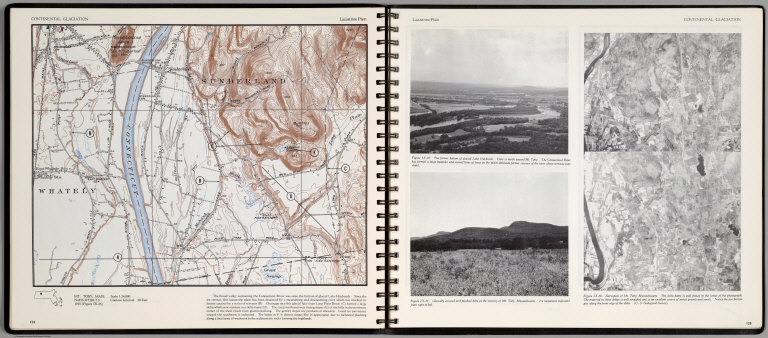
Full Title
Continental Glaciation. Lacustrine Plain. Mt. Toby, Mass. (on opposite page) Stereopair of Mt. Toby, Massachusetts. (with two views)The former bottom of glacial Lake Hitchcock; Glacially scoured and plucked hills in the vicinity of Mt. Toby, Massachusetts ...
List No
0889.066
Note
Color map, with text, and location map. Relief shown by contours and spot heights.
Author
[Scovel, James L., O'Brien, Emmett J]
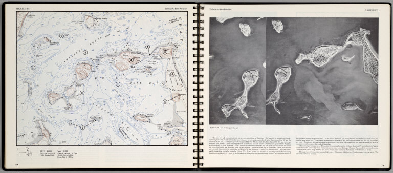
Full Title
Shorelines. Embayed-Semi-Resistant. Hull, Mass. (on opposite page view of) The coast of Hull, Massachusetts.
List No
0889.071
Note
Contour color map, with location map and text. Relief shown by contours and spot heights.
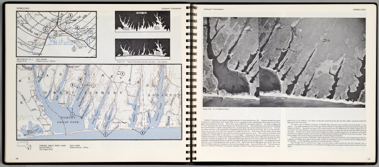
Author
[Scovel, James L., O'Brien, Emmett J]
Full Title
Shorelines. Embayed-Nonresistant. Tisbury, Great Pond, Mass. (insets) Providence, R.I., and Outwash Plain before and after water attack. (with a view on opposite page).
List No
0889.072
Note
Contour color map, with location map and text. Inset shows the view of Tisbury Great Pond. Relief shown by contours and spot heights.
Author
Society for the Diffusion of Useful Knowledge (Great Britain)
Full Title
Boston with Charlestown and Roxbury. Published under the superintendence of the Society for the Diffusion of Useful Knowledge. Engraved by B.R. Davies. London, published by Chapman & Hall, 186, Strand, August 1842. (1844)
List No
0890.166
Note
Engraved map. Relief shown by hachures. Hand col.
Author
Tanner, Henry S.
Full Title
Massachusetts and Rhode Island by H.S. Tanner. (inset) Boston.
List No
0976.013
Author
Tanner, Henry S.
Full Title
Massachusetts And Rhode Island: By H.S. Tanner. Engraved by J. & W.W. Warr. (with) Boston. Entered ... 1833 by H.S. Tanner ... Pennsylvania. Philadelphia Published by H.S. Tanner. (above neat line) Tanner's Universal Atlas.
List No
0977.008
Note
In full color by county or area with a statistical table giving populations by county.
Author
Tanner, Henry S.
Full Title
Boston. (to accompany) The American Traveller; Or Guide Through the United States. Containing Brief Notices of the Several States, Cities, Principal Towns ... Third Edition. By H.S. Tanner. Philadelphia: Published by the Author, No. 51 South Third Street. 1837. (on verso) Entered ... 1836, by H.S. Tanner ... Pennsylvania.
List No
0978.006
Note
Uncolored map. With references to places. 3rd edition; 1st was 1834; map unchanged. Catalog of Tanner's works at end of book. 144 page Guide Book with four maps of city plans. Fifth map is a large colored map entitled, "The Traveller's Guide or Map of the Roads, Canals & Rail Roads of the United States, With the distances from place to place by H.S. Tanner." At bottom of map, "Entered ... 1834, by H.S. Tanner ... Pennsylvania." Bound with linen embossed with a rose pattern. Label on cover states, "Tanner's American Traveller, or Guide through the United States."
Author
Tanner, Henry S.
Full Title
Massachusetts and Rhode Island by H.S. Tanner. (inset) Boston.
List No
0980.013
Author
Tanner, Henry S.
Full Title
Boston (to accompany) The American Traveller, or Tourists' and Emigrants' Guide Through the United States. Containing Brief Notices of the Several States, Cities, Principal Towns ... Ninth Edition, with several additional routes, and A New Map ... By H.S. Tanner. New York: Published by T.R. Tanner, 153 Broadway. 1844. (on verso) Entered ... 1844, by H.S. Tanner ... New York.
List No
0983.006
Note
Uncolored map. With references to places. Bookplate of Tanner's Map Store, N.Y. 144 page Guide Book. Includes maps and reference guides. New copyright notice of 1844 indicating that this is a very late edition; the map is changed from the earlier editions but is still copyright 1834, as in the earlier editions. Full color map entitled, "The Travellers Guide or Map of The Roads, Canals & Rail Roads of the United States, With the distances from place to place by H.S. Tanner 1844." at bottom, "Entered ... 1834, by H.S. Tanner ... Pennsylvania." Bound in linen with gild title, "Tanner's American Traveller or Guide through the United States with Maps, Plans &c."
Author
Blaeu, Joan, 1596-1673
Full Title
Nova Belgica Et Anglia Nova
List No
10017.643
Note
20 Milliaria Germanica communia = 4.6 cm
Author
Tripp, B. Ashburton, 1887-1955
Full Title
Martha's Vineyard : Dukes County, Massachusetts. (Copyright) B. Ashburton Tripp. D&B. Published by B. Ashburton Tripp: Alexandria, Virginia. First Edition.
List No
10082.000
Note
Detailed hand colored pictorial map showing the Island of Martha's Vineyard in center. Relief shown pictorially. Includes towns, roads, lighthouses, forests and waterways. Surrounded by sketches of naval boats and fantasy portraits of the four winds in each corner. Vignettes bordering the map showing maritime scenes in each corner, churches and lighthouses. An inscription borders the entire scene. Inscription along bottom margin reads, ""This is the goodliest land we ever saw for it is replenished with fair fields and in them fragrant flowers."" Inscription along side and top margins reads, "We stood awhile like men ravished at the beautie and delicacie of the sweet soile; for besides rivers clear lakes of fresh water we saw meadows very large and hedged with stately groves - There was such an incredible store of vines we could not go for treading on them.' The Voyage of Bartholomew Gosnold - 1602." Signed and dated in ink at the bottom right, B. Ashburton Tripp, '54. Tripp died the next year, 1955, so we presume this was his last map.
Author
[Touring club italiano, Funk & Wagnalls Company.]
Full Title
(Legend to) Stati Uniti, United States of America, Massachusetts, Connecticut, Rhode Island, New Jersey, Delaware, Maryland, con parte di Pennsylvania, New York, Vermont, New Hampshire. Propr. Artistico-letteraria del T.C.I. Ufficio cartografico del T.C.I. (1929)
List No
1012CO
Note
Explanation to map.
Author
United States. Post Office Department
Full Title
New Hampshire, Vermont, Massachusetts, Rhode Island, Connecticut and Parts of New York and Maine.
List No
10435.002
Note
Updated to 1879 from 1866. 8 panels.
Author
Geological Survey (U.S.)
Full Title
No. 1. Mass.-Conn.-N.Y. Sheffield sheet. U.S. Geological Survey, J.W. Powell, Director. State of Connecticut ... State of Massachusetts ... commissioners. Henry Gannett, Chief Geographer. Marcus Baker, Geographer in charge. Triangulation by S. Borden and H.F. Walling. Topography by E.W.F. Natter. Surveyed in 1884-1885. (1893)
List No
1084.001
Note
Col. topographic map showing settlements, township boundaries, roads, railroads, streams, buildings, etc. Relief shown by contours and spot heights.
Author
Geological Survey (U.S.)
Full Title
No. 2. Connecticut-Massachusetts, Sandisfield sheet. U.S. Geological Survey, J.W. Powell, Director. State of Connecticut ... State of Massachusetts ... commissioners. Henry Gannett, Chief Geographer. Marcus Baker, Geographer in charge. Triangulation by the U.S. Coast and Geodetic and Borden surveys. Topography by W.H. Lovell, under the direction of Willard D. Johnson, topographer. Surveyed in 1886. (1893)
List No
1084.002
Note
Col. topographic map showing settlements, township boundaries, roads, railroads, streams, buildings, etc. Relief shown by contours and spot heights.
Author
Geological Survey (U.S.)
Full Title
No. 3. Mass.-Conn. Granville sheet. U.S. Geological Survey, J.W. Powell, Director. State of Connecticut ... State of Massachusetts ... commissioners. Henry Gannett, Chief Geographer. Marcus Baker, Geographer in charge. Triangulation by the U.S. Coast and Geodetic and Borden surveys. Topography by C.C. Bassett, under the direction of W.D. Johnson, topographer. Surveyed in 1886-7. (1893)
List No
1084.003
Note
Col. topographic map showing settlements, township boundaries, roads, railroads, streams, buildings, etc. Relief shown by contours and spot heights.
Author
Geological Survey (U.S.)
Full Title
No. 4. Massachusetts-Connecticut. Springfield sheet. U.S. Geological Survey, J.W. Powell, Director. State of Connecticut ... State of Massachusetts ... commissioners. Henry Gannett, Chief Geographer. Marcus Baker, Geographer in charge. Triangulation by U.S. Coast and Geodetic Survey and Borden surveys. Topography by C.C. Bassett and C. Arrick, under direction of W.D. Johnson and S.H. Bodfish. Surveyed in 1886 and 1887. (1893)
List No
1084.004
Note
Col. topographic map showing settlements, township boundaries, roads, railroads, streams, buildings, etc. Relief shown by contours and spot heights.
Author
Geological Survey (U.S.)
Full Title
No. 5. Mass.-Conn. Palmer sheet. U.S. Geological Survey, J.W. Powell, Director. State of Connecticut ... State of Massachusetts ... commissioners. Henry Gannett, Chief Geographer. Marcus Baker, Geographer in charge. Triangulation by the U.S. Coast and Geodetic Survey. Topography by C. Arrick, D.J. Howell, W. Kramer and R. Robertson under the direction of S.H. Bodfish and E.W.F. Natter. Surveyed in 1886-7. (1893)
List No
1084.005
Note
Col. topographic map showing settlements, township boundaries, roads, railroads, streams, buildings, etc. Relief shown by contours and spot heights.
Author
Geological Survey (U.S.)
Full Title
No. 6. Massachusetts-Connecticut. Brookfield sheet. U.S. Geological Survey, J.W. Powell, Director. State of Connecticut ... State of Massachusetts ... commissioners. Henry Gannett, Chief Geographer. Marcus Baker, Geographer in charge. Triangulation by the U.S. Coast and Geodetic and Borden surveys. Topography by E.W.F. Natter and W.J. Grambs. Surveyed in 1886-7. (1893)
List No
1084.006
Note
Col. topographic map showing settlements, township boundaries, roads, railroads, streams, buildings, etc. Relief shown by contours and spot heights.
Author
Geological Survey (U.S.)
Full Title
No. 7. Mass.-Conn.-R.I. Webster sheet. U.S. Geological Survey, J.W. Powell, Director. State of Connecticut ... State of Massachusetts ... commissioners. Henry Gannett, Chief Geographer. Marcus Baker, Geographer in charge. Triangulation by the U.S. Coast and Geodetic and Borden surveys. Topography by C.C. Bassett and R.H. Phillips under direction of W.D. Johnson, topographer. Surveyed in 1886-7. (1893)
List No
1084.007
Note
Col. topographic map showing settlements, township boundaries, roads, railroads, streams, buildings, etc. Relief shown by contours and spot heights.
Author
Hamilton, Harold Webb
Full Title
Cape Cod. Drawn by Harold Webb Hamilton - 1938 - For the Weaver Bird Studio - Hyannis . Trade mark No. 195716 - (Copyright) Hyannis, Mass. 1938.
List No
11054.000
Note
Cod, with decorative title cartouche. Shows boats, ships and fish in the water, towns, roads, lakes, and rivers. Bordered by illustrations of Cape Cod plants and fish on right and left and mountains and sea on top and bottom margins. Includes a decorative compass rose at the center. Relief shown pictorially.
Author
Paige, Paul
Full Title
A map of Cape Cod. Paul Paige, East Brewster, Mass.
List No
11271.000
Note
Pictorial map of Cape Cod, Massachusetts, in an Art Deco style, Showing towns, points of interest and lighthouses, people enjoying sporting and recreational activities, ocean fish and different types of sailboats, and depictions of ships of some early explorers and settlers including a Viking ship, the Mayflower, and the vessels of John Smith and Champlain. At the center of the bottom border, two seahorses flank a clamshell. An orange and green ribbon across the map gives some statistics: "586 Miles of Shoreline, 300 Miles of Beaches, 1000 Miles of Highway, As Many Miles of Byways, 300 Lakes." A verse accompanied by a small landscape drawing in lower left corner reads: A "Key to the Cape" which incorporates a drawing of an actual key, also indicates airports, golf courses, life saving stations and yacht clubs with small symbols. Date estimated. Includes title cartouche and text.
Author
Chase, Ernest Dudley, 1878-1966
Full Title
A pictorial map of Wellesley, Massachusetts : designed and drawn by Ernest Dudley Chase for the Wellesley National Bank.
List No
11275.000
Note
Color pictorial map of suburb of Boston. Shows all the roads, railroads, buildings, landmarks, Indian settlements, points of interest, etc. Borders with vignettes of landmarks and prominent institutions in the town including Babson College, Pine Manor Jr College, the Wellesley Country club. Includes text and numbered index. Date estimated.
Author
Atherton, Jack
Full Title
Cape Ann. Litho in U.S.A. Published by Hagstrom Co., Inc. N.Y.C.
List No
11276.000
Note
Detailed color pictorial map of Cape Ann on Coastal Massachusetts. Shows sites and landmark structures, towns, beaches, islands, state roads, railroads, light houses, sea ports, and bodies of water. On the bottom including depictions of vessels from different eras. Note: "Cape Ann is located on the Massachusetts sea coast: 33 miles north of Boston". Date estimated.
Author
Galbraith, Carolyn H.
Full Title
Smith College Campus. (second edition). Copyright 1928 by Carolyn H. Galbraith.
List No
11366.000
Note
Color pictorial map of Smith College, Massachusetts. Second edition. Covered with buildings, and facilities, with humorous notes and compass rose decorated with Seal of Smith College. Showing highways, roads, and games in progress. Carolyn H. Galbraith initial in lower right. Borders with vignettes of prominent people, buildings and various campus scenes. Library has 1938 edition see: 12029.000.
Author
[Healy, Lauren H., Sprague, William B. Jr.]
Full Title
A map of Williams College in the year 1935, Lauren H. Healy & William B. Sprague, Jr., executors. (In upper panel) E Liberalitate E. Williams Armigeri.
List No
11380.000
Note
Bird's-eye view pictorial map of Williams College campus, Massachusetts. Shows buildings, facilities, and streets, with humorous images and notes: The Hopkins Log, Frosh Playground, The Latin Requirement, etc. Borders with illustrations of students and campus activities.
Author
[Walling, H.F., Hitchcock, C.H.]
Full Title
(Text Page) Appendix, Connecting Lines to Boston and New York (concluded). New Hampshire Business Notices. Patrons of this Work.
List No
1149.044
Author
[Dutton, E. P., Walling, H. F.]
Full Title
Map Of Boston And The Country Adjacent, From Actual Surveys By H.F. Walling Supt. Of The State Map. Published At The Boston Map Store By E.P. Dutton & Co. 106 Washington St. Boston, 1860. Entered ... 1860 by E.P. Dutton & Co. ... Massachusetts. Printed by Meisel Brothers.
List No
1150.000
Note
Full color. Dissected into 36 sections and mounted on linen. Folds into end sheets of red marbled paper 18x14 and a new gray slip case 19x14.5 with "Boston And The Country Adjacent. H.F. Walling 1860" stamped in gilt on the spine.
Author
[Gray, Ormando Willis, Walling, H. F.]
Full Title
(Covers to) Official topographical atlas of Massachusetts, from astronomical, trigonometrical and various local surveys; compiled and corrected by H.F. Walling & O.W. Gray, 102 Chauncy St., Boston. Published by Stedman, Brown & Lyon, 1871.
List No
1154A
Note
Bound in half leather dark brown cloth covered boards with "Atlas of the State of Massachusetts" stamped in gilt on the front cover and blind stamped on the back.
Author
[Gray, Ormando Willis, Walling, H. F.]
Full Title
(Title Page to) Official topographical atlas of Massachusetts, from astronomical, trigonometrical and various local surveys; compiled and corrected by H.F. Walling & O.W. Gray, 102 Chauncy St., Boston. Published by Stedman, Brown & Lyon, 1871.
List No
1154B
Note
Includes illustration.
Author
[Gray, Ormando Willis, Walling, H. F.]
Full Title
(Contents to) Official topographical atlas of Massachusetts, from astronomical, trigonometrical and various local surveys; compiled and corrected by H.F. Walling & O.W. Gray, 102 Chauncy St., Boston. Published by Stedman, Brown & Lyon, 1871.
List No
1154C
Note
Table of contents.
Author
[Gray, Ormando Willis, Hitchcock, Charles H. (Charles Henry), 1836-1919, Walling, H. F.]
Full Title
Geological map of Massachusetts, compiled by C.H. Hitchcock, Ph.D., professor of geology in Dartmouth College. H.F. Walling & O.W. Gray, Boston, 1871.
List No
1154.001
Note
Hand col. lithographed map. Shows 24 geologic units plus deposits or beds of marl, iron, lead, copper, manganese and zinc. Includes text and drawing of Paradoxides harlani (fig. 1.).
Author
[Blodget, Lorin, Gray, Ormando Willis, Walling, H. F.]
Full Title
Climatological map of Massachusetts showing the average temperature, amount of rain fall &c. by Lorin Blodgett (i.e. Blodget. H.F. Walling & O.W. Gray, Boston, 1871)
List No
1154.002
Note
Lithographed map. Includes text: The climate of Massachusetts by Lorin Blodget ...
Author
[Gray, Ormando Willis, Walling, H. F.]
Full Title
Map of Massachusetts comprising counties, towns, villages, railroads, stations, etc. H.F. Walling & O.W. Gray, Boston, 1871.
List No
1154.005
Note
Hand col. lithographed map. Includes table of "Railways of Massachusetts" and "Boston & vic. railway stations." "Entered according to Act of Congress in the year 1870 by Walling & Gray in the Office of the Librarian of Congress."
Full Title
Berkshire County. (H.F. Walling & O.W. Gray, Boston, 1871)
List No
1154.006
Note
Hand col. lithographed map. Relief shown by hachures and spot heights. Shows towns, settlements, school houses, churches, roads, railroads, canals, marshes, etc.
Full Title
Franklin County. (H.F. Walling & O.W. Gray, Boston, 1871)
List No
1154.007
Note
Hand col. lithographed map. Relief shown by hachures. Shows towns, settlements, school houses, churches, roads, railroads, canals, marshes, etc.
Full Title
Hampshire County, Hampden County. (H.F. Walling & O.W. Gray, Boston, 1871)
List No
1154.008
Note
Hand col. lithographed map. Relief shown by hachures and spot heights. Shows towns, settlements, school houses, churches, roads, railroads, canals, marshes, etc.
Full Title
Worcester County. (H.F. Walling & O.W. Gray, Boston, 1871)
List No
1154.009
Note
Hand col. lithographed map. Relief shown by hachures and spot heights. Shows towns, settlements, school houses, churches, roads, railroads, etc.
Full Title
Middlesex County. (H.F. Walling & O.W. Gray, Boston, 1871)
List No
1154.010
Note
Hand col. lithographed map. Relief shown by hachures and spot heights. Shows towns, settlements, school houses, churches, roads, railroads, marshes, etc.
Full Title
Essex County. Norfolk County. (H.F. Walling & O.W. Gray, Boston, 1871)
List No
1154.011
Note
Two hand col. lithographed maps on 1 sheet. Relief shown by hachures. Shows towns, settlements, school houses, churches, roads, railroads, marshes, etc.
Full Title
Bristol County. (H.F. Walling & O.W. Gray, Boston, 1871)
List No
1154.012
Note
Hand col. lithographed map. Relief shown by hachures and spot heights. Shows towns, settlements, school houses, churches, roads, railroads, marshes, etc.
Full Title
Plymouth County. (H.F. Walling & O.W. Gray, Boston, 1871)
List No
1154.013
Note
Hand col. lithographed map. Relief shown by hachures and spot heights. Shows towns, settlements, school houses, churches, roads, railroads, marshes, etc.
Full Title
Barnstable County. (with) Dukes (County). (with) Nantucket. (H.F. Walling & O.W. Gray, Boston, 1871)
List No
1154.014
Note
Hand col. lithographed map. Relief shown by hachures. Shows towns, settlements, school houses, churches, roads, railroads, marshes, etc.
Author
[Gray, Ormando Willis, Walling, H. F.]
Full Title
Map of the compact portions of Boston and the adjacent cities and towns. H.F. Walling & O.W. Gray, Boston, 1871.
List No
1154.015
Note
Hand col. lithographed map. Shows wards, streets, railroads, major buildings, bridges, ferries, etc. Inset: Map showing the present limits of the city of Boston, 1871.
Full Title
City of Springfield. (H.F. Walling & O.W. Gray, Boston, 1871)
List No
1154.016
Note
Hand col. lithographed map. Shows wards, streets, railroads, major buildings, bridges, etc.
Full Title
City of Worcester. (H.F. Walling & O.W. Gray, Boston, 1871)
List No
1154.017
Note
Hand col. lithographed map. Shows wards, streets, railroads, major buildings, etc.
Author
Baker, R. W.
Full Title
City of Lowell. Reduced by permission from the large map by R.W. Baker. (H.F. Walling & O.W. Gray, Boston, 1871)
List No
1154.018
Note
Hand col. lithographed map. Shows wards, streets, railroads, major buildings, commons, cemeteries, bridges, etc.
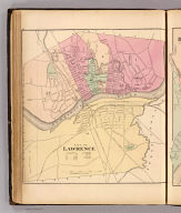
Full Title
City of Lawrence. (H.F. Walling & O.W. Gray, Boston, 1871)
List No
1154.019
Note
Hand col. lithographed map. Shows wards, streets, railroads, major buildings, bridges, dam, commons, cemetery, etc.
Full Title
City of Haverhill. (H.F. Walling & O.W. Gray, Boston, 1871)
List No
1154.020
Note
Hand col. lithographed map. Shows wards, streets, railroads, major buildings, bridges, commons, cemeteries, etc.
Full Title
City of Newburyport. (H.F. Walling & O.W. Gray, Boston, 1871)
List No
1154.021
Note
Hand col. lithographed map. Shows wards, streets, railroads, major buildings, bridges, etc.
Full Title
City of Salem. (H.F. Walling & O.W. Gray, Boston, 1871)
List No
1154.022
Note
Hand col. lithographed map. Shows wards, streets, railroads, major buildings, bridges, cemeteries, etc.
Full Title
City of Lynn. (H.F. Walling & O.W. Gray, Boston, 1871)
List No
1154.023
Note
Hand col. lithographed map. Shows wards, streets, railroad, major buildings, etc.
Full Title
City of Fall River. (H.F. Walling & O.W. Gray, Boston, 1871)
List No
1154.024
Note
Hand col. lithographed map. Shows wards, streets, railroads, major buildings, etc.
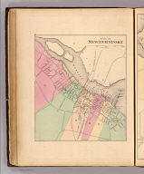
Full Title
City of New Bedford. (H.F. Walling & O.W. Gray, Boston, 1871)
List No
1154.025
Note
Hand col. lithographed map. Shows wards, streets, railroads, major buildings, bridges, etc.
Author
[Town Crier Shop, Holliday, C.W.]
Full Title
Cape Cod and Islands. Published by Town Crier Shop, Provincetown, Mass.
List No
11618.000
Note
Uncolored pictorial map of the Cape Cod, Marthas Vineyard, and Nantucket. Title cartouche decorated with cod fish and sea horses. Shows roads, cities, coastal towns, forest and Native American settlements in the center. Includes illustrations of birds, ships and sea creatures. Decorative border vignettes featuring famous island scenery, buildings, ships, and light houses with explanatory text. Includes decorative compass rose oriented with the north to upper left. Date estimated.
Author
Meyer, Joseph, 1796-1856
Full Title
Die staaten von Maine, New Hampshire, Massachusetts, Vermont, Connecticut & Rhode I. 1850. (United States of North America). Stahlstich (Direction v. Kleinknecht) aus der Schweinfurter Geographischen Graviranstalt des Bibliographischen Instituts zu Hildburghausen, Amsterdam, Paris u. Philadelphia. (in upper margin) Meyer's Zeitung Atlas. No. 69. (to accompany) Neuester Zeitungs-Atlas fur Alte und Neue Erdkunde. Herausgegeben von J. Meyer. (insets) Boston. (with) New Haven. (with) Hartford.
List No
11652.093
Note
Engraved outline hand color map of New England. Shows administrative boundaries, cities and towns. Relief shown by hachures. Prime meridians are Greenwich and Washington.
Author
Galbraith, Carolyn
Full Title
A Map of Smith College Campus 1938.
List No
12029.000
Author
Goos, Pieter, 1616-1675
Full Title
Pas caerte van Nieu Nederlandt en de Engelsche Virginies.
List No
12179.040
Author
[Weiland, Carl Ferdinand, 1782 -1847, Hassel, Georg, 1770-1829]
Full Title
Geographisch-statistische und historische Charte von Massachusetts.
List No
12293.018
Author
Waugh, Coulton, 1896-1973
Full Title
Cape Ann and the North Shore. A map displaying the hardy maritime development of these historic parts.
List No
12323.000
Author
[Nirenstein, Nathan, Bowers, M.L.]
Full Title
(Text Page) Springfield (Massachusetts). (Index Map) (Massachusetts).
List No
12504.108
Note
Undersized sheet.
Author
[Nirenstein, Nathan, Bowers, M.L.]
Full Title
(Text Page) Springfield, Rich in Tradition and Opportunity. (Map) (Western Massachusetts.)
List No
12504.111
Author
Trustees of Reservations (Mass.)
Full Title
Bay Circuit. Trustees of Public Reservations, 50 Congress street, Boston Massachusetts.
List No
13074.000
Note
Color map of the Bay Circuit. Shows place names, roads, distances, etc. Includes index to motor routes that intersect the Bay Circuit, and points of geological, ornithological, historical, and antiquarian interest. Date estimated. The map was created by Charles Eliot II, nephew of the Trustees of Reservations founder.
Author
Mitchell, John
Full Title
Mr. Jay's map, extract from a map of the British & French dominions in North America. by Jno. Mitchell. Drawn for the New York Historical Society May 1842. Reprinted 1938 by U.S. Geological Survey. New York : Printed for the Society 1843. (in upper margin) Massachusetts (Eastern part, i.e., The District of Maine) at the time of the ratification of the constitution, from original maps ... including one based upon a Mitchell map ... Issued by the United States Constitution Sesquicentennial Commission.
List No
13081.003
Note
Map of the District of Maine. With insets: A map of the district of Maine ... by Carleton Osgood; (Massachusetts and the District of Maine). In upper margin: "Massachusetts (Eastern part, i.e., The District of Maine) at the time of the ratification of the constitution, from original maps in the Library of Congress at Washington including one based upon a Mitchell map owned and used by John Jay, first Chief Justice of the United States." Relief shown by hachures. Prime meridian is Philadelpha. Includes historical text and dedication text. Series: "This map is one of a series of similar colored maps, depicting the 13 original states, from New Hampshire to Georgia at the time of the formation of the Constitution ..."
Author
Jefferys, Thomas
Full Title
Map of the most inhabited part of New England, containing the provinces of Massachusetts Bay and New Hampshire, with the colonies of Connecticut and Rhode Island ... 1774 published by ... Thos. Jefferys ... November 29th 1774. Reprinted 1938 by U.S. Geological Survey. (in upper margin) Massachusetts (without the District of Maine) at the time of the ratification of the constitution, from original maps ... Issued by the United States Constitution Sesquicentennial Commission.
List No
13081.005
Note
Map of Massachusetts. With insets: A plan of the town and harbour of Boston and the country adjacent by I. De Costa; To the Honl. Jno. Hancock ... this map of the seat of Civil War in America, is respectfully inscribed by ... B. Romans; A portion showing New England, of a "Map of the United States, exhibiting the post ... roads ... By Abraham Bradley, junr. "This map compiled by John Green." Relief shown by hachures. Prime meridian is London. Includes historical and dedication text. Series: "This map is one of a series of similar colored maps, depicting the 13 original states, from New Hampshire to Georgia at the time of the formation of the Constitution ..."
Author
Beers, Frederick W.
Full Title
Plan of Massachusetts Rhode Island and Connecticut. Drawn and engraved especially for this atlas. (to accompany) County atlas of Hampshire, Massachusetts ... Published by F. W. Beers & Co., 36 Vesey Street, New York. 1873.
List No
13125.007
Note
Detailed map showing state and county boundaries, cities and towns, canals and roads.
Author
Beers, Frederick W.
Full Title
Plan of Hampshire Co. Mass. (to accompany) County atlas of Hampshire, Massachusetts ... Published by F. W. Beers & Co., 36 Vesey Street, New York. 1873.
List No
13125.008
Note
Detailed map showing cities and towns, canals, rivers and roads. Relief shown by hachures.
Author
Luffman, John, 1756-1846
Full Title
Boston. Engraved for Luffman's Select plans. Engrav'd & Publish'd March 1.1802, by J. Luffman. London.
List No
13189.156
Note
Hand colored city map. Shows Boston Harbor, small islands, and towns. Prime meridian is London. Includes text at the foot of map.
Author
Bodley, Helen
Full Title
(Covers to) A map of Concord, the old Musketaquid Plantation. H. Bodley. Copyright 1928 by Houghton, Mifflin Company. (cover title) The map of Concord : by Helen Bodley. Published by Houghton, Mifflin., Boston Mass.
List No
13333.001
Author
Bodley, Helen
Full Title
A map of Concord, the old Musketaquid Plantation. H. Bodley. Copyright 1928 by Houghton, Mifflin Company. (cover title) The map of Concord : by Helen Bodley. Published by Houghton, Mifflin., Boston Mass.
List No
13333.002
Author
Finley, Anthony
Full Title
Massachusetts. Young & Delleker Sc. Published by A. Finley Philada. (to accompany) A new general atlas, comprising a complete set of maps, representing the grand divisions of the globe ... 1836.
List No
13379.014
Note
Full color map by administrative divisions. Inset: Map Of The Country in the vicinity of Boston.
Author
Paine, Perscilla
Full Title
A map of the town of Northampton Mass. Petition to the General Court to plant, possess, and inhabit Nonotuck May 1653. Designed by Perscilla Paine. Published by Hampshire Bookshop, Northampton, Mass. Cartouche by Hester R. Hoffman. Copyright 1934.
List No
13649.000
Author
Archar Inc.
Full Title
Boston : City Character Print. Produced and published by Archar Inc. Mississuga, Ontario. Copyright 1980.
List No
13650.000
Author
[3, Soviet Union. Glavnoe upravlenie geodezii i kartografii]
Full Title
Новая Англия = Novaia Angliia. 232. Atlas Mira : 1954.
List No
13682.245
Note
Physical map of New England. Relief shown by shadings and spot heights. Depths shown by gradient tints, isolines and soundings.
Author
[George F. Cram Company collection 1845-1955, National Highways Association]
Full Title
Massachusetts. The George F. Cram Company, Chicago. (to accompany) Auto trails and commercial survey of the United States.
List No
13688.045
Note
State of Massachusetts. Insets: Boston and vicinity. Map showing electric lines and administrative boundaries.
Author
[George F. Cram Company collection 1845-1955, National Highways Association]
Full Title
Massachusetts. The George F. Cram Company, Chicago. (to accompany) Auto trails and commercial survey of the United States.
List No
13688.046
Note
State of Massachusetts. Insets: Boston and vicinity. Map showing Main traveled highways.
Author
Rand McNalley & Company
Full Title
Rand McNally road map : Connecticut -- Massachusetts -- Rhode Island.
List No
14003.016
Note
Road map of Connecticut, Massachusetts and Rhode Island, showing interstate and state highways, paved and dirt roads, ferries and boatlines, as well as state and national parks. Includes compass rose, time zones, and bar scale with scale statement: One inch equals approximately 9.6 miles. Features legend indicating population. Copyright by Rand McNally & Company, Chicago, Ill. Lithographed in the U.S.A.
Author
Cram, George Franklin, 1841-1928
Full Title
Commercial railroad and county map of Massachusetts and Rhode Island. 1899, by Geo. F. Cram.
List No
14372.012
Note
Map of Massachusetts and Rhode Island. Shows political boundaries, counties, towns, railroads, steamship lines, topography, bodies of water, drainage, coastlines and islands. Relief shown with hachures. Includes key with explanation, latitudinal and longitudinal lines, as well as a bar scale given in miles. With alphanumeric grid corresponding to "Index of Massachusetts" on pages 17-19 and 22, and "Index of Rhode Island" on page 23. Colored lithograph. Map is 40 x 57 cm, on double sheet 45 x 67 cm. "Index of maps" and "Index of cities" in margins, providing navigation for atlas as a whole.
Author
Mid-West Map Company
Full Title
Highway map & guide of Massachusetts, Connecticut & Rhode Island. Mid-West Map Co. Aurora, Mo.
List No
14421.002
Note
Pocket road map for the states of Massachusetts, Connecticut and Rhode Island. Shows state boundaries, cities, highways, roads, airports, topography, bodies of water, drainage and coastline. Relief shown with hachures. Includes explanatory text, a legend, bar scale given in miles, and compass rose with north oriented toward top of sheet. Indexed, with key on verso. Advertisements in margins. Printed in blue. Map is 40 x 53 cm, on sheet 44 x 56 cm.
Author
Greenleaf, Jeremiah
Full Title
Massachusetts, Rhode Island, And Connecticut.
List No
15176.042
Note
Full color by county. Engraved. Relief shown by hachures. Meridians Greenwich and Washington.
Author
Colton, G.W.
Full Title
Colton's Massachusetts, Connecticut and Rhode Island. Published by G. W & C. B. Colton & Co., No. 182 William St. New York.
List No
1550.024
Note
Prime meridians are Washington D.C. and Greenwich.
Author
Colton, G.W.
Full Title
Colton's Boston and Adjacent Cities. Published by G. W & C. B. Colton & Co., No. 182 William St. New York.
List No
1550.025
Author
[Black, Adam, Black, Charles]
Full Title
Vermont, New Hampshire, Massachusetts, Connecticut & Rhode Island.
List No
1585.061
Author
USSR (Union of Soviet Socialist Republics).
Full Title
199. New England. The World Atlas.
List No
1603.210
Author
[Colton, G.W., Fisher, Richard Swainson]
Full Title
Vermont, Massachusetts, Rhode Island, and Connecticut. (inset) Vicinity of Boston.
List No
1690.056
Note
Relief depicted by hachures.
Author
[Cram, George, Wood Brothers]
Full Title
Massachusetts and Rhode Island. (to accompany) The Columbian World's Fair atlas ... Published for: Wood Brothers Cash Store ... Unadilla, New York. (inset map of Boston).
List No
1773.051
Note
Outline hand color map. Shows state and county boundaries, cities and towns. Relief shown by hachurs. Prime meridians are Greenwich and Washington.
Author
[Cram, George Franklin, Murray-Aaron, Eugene, 1852-1941.]
Full Title
Massachusetts and Rhode Island. Published by Geo. F. Cram, Chicago, Ill. (to accompany) Cram's atlas of the world, ancient and modern : new census edition -- indexed. (inset map of Boston).
List No
1910.021
Note
Outline map in full color on 2 pages. Shows state lines, administrative divisions, cities and towns, railroads, wagon roads, rives, etc. Relief shown by hachures. Prime meridians are Greenwich and Washington.
Author
Hammond, C.S.
Full Title
Southern New England. Massachusetts, Connecticut, and Rhode Island. 9357.
List No
1954.068
Author
[Walker, G.H., Walker, O.W.]
Full Title
Index Map Massachusetts 1891.
List No
2006.008
Author
[Walker, G.H., Walker, O.W.]
Full Title
Massachusetts. Atlas Plate No. 1.
List No
2006.009
Author
[Walker, G.H., Walker, O.W.]
Full Title
Massachusetts. Atlas Plate No. 2.
List No
2006.012
Author
[Walker, G.H., Walker, O.W.]
Full Title
Massachusetts. Atlas Plate No. 3.
List No
2006.015
Author
[Walker, G.H., Walker, O.W.]
Full Title
Massachusetts. Atlas Plate No. 5.
List No
2006.019
Author
[Walker, G.H., Walker, O.W.]
Full Title
Massachusetts. Atlas Plate No. 6.
List No
2006.032
Author
[Walker, G.H., Walker, O.W.]
Full Title
Massachusetts. Atlas Plate No. 7.
List No
2006.034
Author
[Walker, G.H., Walker, O.W.]
Full Title
Massachusetts. Atlas Plate No. 8.
List No
2006.035
Author
[Walker, G.H., Walker, O.W.]
Full Title
Massachusetts. Atlas Plate No. 9.
List No
2006.036
Author
[Walker, G.H., Walker, O.W.]
Full Title
Massachusetts. Atlas Plate No. 10.
List No
2006.037
Author
[Walker, G.H., Walker, O.W.]
Full Title
Massachusetts. Atlas Plate No. 11.
List No
2006.038
Author
[Walker, G.H., Walker, O.W.]
Full Title
Massachusetts. Atlas Plate No. 12.
List No
2006.039
Author
[Walker, G.H., Walker, O.W.]
Full Title
Massachusetts. Atlas Plate No. 13.
List No
2006.040
Author
[Walker, G.H., Walker, O.W.]
Full Title
Massachusetts. Atlas Plate No. 14.
List No
2006.043
Author
[Walker, G.H., Walker, O.W.]
Full Title
Massachusetts. Atlas Plate No. 15.
List No
2006.045
Author
[Walker, G.H., Walker, O.W.]
Full Title
Massachusetts. Atlas Plate No. 16.
List No
2006.046
Author
[Walker, G.H., Walker, O.W.]
Full Title
Massachusetts. Atlas Plate No. 17.
List No
2006.047
Author
[Walker, G.H., Walker, O.W.]
Full Title
Massachusetts. Atlas Plate No. 18.
List No
2006.049
Author
[Walker, G.H., Walker, O.W.]
Full Title
Massachusetts. Atlas Plate No. 19.
List No
2006.051
Author
[Walker, G.H., Walker, O.W.]
Full Title
Massachusetts. Atlas Plate No. 20.
List No
2006.052
Author
[Walker, G.H., Walker, O.W.]
Full Title
Massachusetts. Atlas Plate No. 21.
List No
2006.053
Author
[Walker, G.H., Walker, O.W.]
Full Title
Massachusetts. Atlas Plate No. 22.
List No
2006.056
Author
[Walker, G.H., Walker, O.W.]
Full Title
Massachusetts. Atlas Plate No. 23.
List No
2006.058
Author
[Walker, G.H., Walker, O.W.]
Full Title
Massachusetts. Atlas Plate No. 24.
List No
2006.060
Author
[Walker, G.H., Walker, O.W.]
Full Title
Massachusetts. Atlas Plate No. 25.
List No
2006.061
Author
[Walker, G.H., Walker, O.W.]
Full Title
Massachusetts. Atlas Plate No. 26.
List No
2006.062
Author
[Walker, G.H., Walker, O.W.]
Full Title
Massachusetts. Atlas Plate No. 27.
List No
2006.064
Full Title
Massachusetts and Rhode Island. Entered ... 1836, by Eleazer Huntington ... Connecticut.
List No
2022.007
Note
Engraved map. Hand colored. Relief shown by hachures. Shows counties, settlements, rivers, etc. Prime meridian: Washington.
Author
Western Rail Road Corporation
Full Title
Route of the Western railroad. West of Connecticut River. 1837. Enlarged from map of the state. T. Moore's Lith. Boston. (to accompany) Reports of The Engineers of the Western Railroad Corporation.
List No
2038.002
Note
Uncolored map. Shows railroad depots with distances from Albany. Covers Massachusetts, Connecticut, and New York. Showing the routes from Springfield west to the border with New York state, connecting at that point with the Hudson and Berkshire Railroad leading to Albany, 38 miles distant. Covers the area from Pittsfield in the upper left, Sandisfield at the lower left, and W. Springfield at lower right.
Author
Western Rail Road Corporation
Full Title
Route of the Western railroad. East of Connecticut River. 1837. Enlarged from map of the state. T. Moore's Lith. Boston. (to accompany) Reports of The Engineers of the Western Railroad Corporation.
List No
2038.003
Note
Uncolored map. Shows railroad depots with distances from Boston. Covers Massachusetts, Connecticut, and New York. showing the routes from Springfield west to the border with New York state, leading to Boston, 48 miles distant.
Author
Bradstreet Company
Full Title
Massachusetts. (to accompany) Bradstreet's Pocket Atlas Of The United States. Published Exclusively for Macullar, Parker & Company, Boston, Massachusetts ... New York: The Bradstreet Company, 1885. (on verso) Entered ... 1879, by The Bradstreet Company ... Washington.
List No
2054.020
Note
Full color map. Relief shown by hachures. Prime meridian is Washington, D.C.
Author
Rand McNally and Company
Full Title
Rand, McNally & Co.'s Massachusetts. (with) Boston (railroads).
List No
2094.019
Note
Counties outlined in color. Meridians Washington and Greenwich. Railroads highlighted. One inset. Relief shown by hachures.
Author
Rand McNally and Company
Full Title
(Text Page) Massachusetts.
List No
2094U
Note
List of geographical features indexed to map.
Author
Rand McNally and Company
Full Title
(Text Page) Massachusetts.
List No
2094V
Note
List of geographical features indexed to map.
Author
Rand McNally and Company
Full Title
(Text Page) Massachusetts.
List No
2094W
Note
List of geographical features indexed to map.
Author
[Heermans, Anna A., Cogswell, Charlotte B.]
Full Title
(Text Page to) Massachusetts. (to accompany) A Hieroglyphic Geography Of The United States. Part 1 Containing The States Of Maine, New Hampshire, Vermont, Massachusetts, Rhode Island, Connecticut And New York. Designed And Drawn By Anna A. Heermans. Engraved By Charlotte B. Cogswell, Cooper Union Engraving School, New York. New York, E.P. Dutton And Company, 713 Broadway, 1875. (on verso) Entered ... 1874, by Charlotte B. Cogswell ... Washington. Riverside, Cambridge: Electrotyped And Printed By H.O. Houghton And Company.
List No
2107.012
Note
Text to the map, illustration and views of State of Massachusetts. This atlas contains very small state maps amongst illustrations and views for each state, followed by a page of text. Covers are red cloth covered boards with "Hieroglyphic Geography Of The United States Part 1" stamped in gilt.
Author
[Heermans, Anna A., Cogswell, Charlotte B.]
Full Title
(View to) Massachusetts. (to accompany) A Hieroglyphic Geography Of The United States. Part 1 Containing The States Of Maine, New Hampshire, Vermont, Massachusetts, Rhode Island, Connecticut And New York. Designed And Drawn By Anna A. Heermans. Engraved By Charlotte B. Cogswell, Cooper Union Engraving School, New York. New York, E.P. Dutton And Company, 713 Broadway, 1875. (on verso) Entered ... 1874, by Charlotte B. Cogswell ... Washington. Riverside, Cambridge: Electrotyped And Printed By H.O. Houghton And Company.
List No
2107.013
Note
Illustration and views of State of Massachusetts. This atlas contains very small state maps amongst illustrations and views for each state, followed by a page of text. Covers are red cloth covered boards with "Hieroglyphic Geography Of The United States Part 1" stamped in gilt.
Author
[Heermans, Anna A., Cogswell, Charlotte B.]
Full Title
(Text Page to) Massachusetts. (to accompany) A Hieroglyphic Geography Of The United States. Part 1 Containing The States Of Maine, New Hampshire, Vermont, Massachusetts, Rhode Island, Connecticut And New York. Designed And Drawn By Anna A. Heermans. Engraved By Charlotte B. Cogswell, Cooper Union Engraving School, New York. New York, E.P. Dutton And Company, 713 Broadway, 1875. (on verso) Entered ... 1874, by Charlotte B. Cogswell ... Washington. Riverside, Cambridge: Electrotyped And Printed By H.O. Houghton And Company.
List No
2107.014
Note
Text to the map, illustration and views of State of Massachusetts. This atlas contains very small state maps amongst illustrations and views for each state, followed by a page of text. Covers are red cloth covered boards with "Hieroglyphic Geography Of The United States Part 1" stamped in gilt.
Author
Bradford, Thomas G.
Full Title
(Text Page to) (Massachusetts). (to accompany) A Comprehensive Atlas, Geographical, Historical & Commercial. By T.G. Bradford. Boston: American Stationers' Company. Entered ... 1835, by Thos. G. Bradford ... Massachusetts.
List No
2120.027
Note
Text to the General map of Massachusetts. Includes population per county and town.
Author
Bradford, Thomas G.
Full Title
Massachusetts. (to accompany) A Comprehensive Atlas, Geographical, Historical & Commercial. By T.G. Bradford. Boston: American Stationers' Company. Entered ... 1835, by Thos. G. Bradford ... Massachusetts.
List No
2120.028
Note
Color map. Shows administrative boundaries, cities and towns, roads, railroads, rivers, canals, mountains, etc. Includes explanation. Relief shown by hachures. Prime meridians are Washington and London.
Full Title
Massachusetts and Rhode Island. (Published by George F. Cram, Chicago, Ill. 1909)
List No
2134.055
Note
Map in full color. Relief shown by hachures. Shows counties, settlements, railroads, etc. Includes inset of Boston Region.
Author
Lloyd, H.H.
Full Title
Atlas of the United States. New England and New York. (by H.H. Lloyd. Published by Stedman, Brown & Lyon, Baltimore. 1873)
List No
2239.021
Note
Hand col. lithographed map. Counties in full color. Relief shown by hachures.
Author
[Nicholson, W. L., United States. Post Office Department]
Full Title
Post Route Map Of The State Of New York And Parts Of Vermont, Massachusetts, Connecticut, New Jersey And Pennsylvania, Showing Also The Adjacent Portions Of The Dominion Of Canada. Designed And Constructed Under The Orders Of Postmaster General Alex. W. Randall And Second Asst. Postmaster General Geo. Wm. McLellan By W.L. Nicholson, Topographer Of P.O. Dept. 1868. Drawn by Paul Goepel. Engraved by D. McClelland, Washn. D.C. (seal) Post Office Department United States Of America "With Celerity, Certainty And Security." (inset) Prov. Of Ontario. (inset) Postal Service Of Long Island With The Principal Mail Connections Of The City Of New York.
List No
2268.000
Note
In the Explanation of the Mail Service note, it reads "The Service on this Diagram brought up to the date of Aug. 1st 1872", with most of the date in ms. Outline color by state. Brown top and bottom rollers.
Author
[Breese, Samuel, 1802-1873, Morse, Sidney E. (Sidney Edwards), 1794-1871]
Full Title
Massachusetts and Rhode Island. (By Sidney E. Morse and Samuel Breese. New York: Published by Harper & Brothers, 1845)
List No
2301.007
Note
Col. wax engraved map. Relief shown by hachures. Prime meridians: Washington and Greenwich.
Author
[Black, Adam & Charles, Hall, Sidney, Hughes, William]
Full Title
New York, Vermont, New Hampshire, Rhode Island, Massachusetts & Connecticut. Edinburgh, Published by A. &. C. Black. Drawn and Engraved by J. Bartholomew, Edinburgh
List No
2305.056
Note
Engraved. Counties shown by tinting.
Author
[Jones, C.H., Hamilton, T.H., Williams, J.David]
Full Title
Map of Maine, New Hampshire, Vermont, Massachusetts, Rhode Island, and Connecticut.
List No
2307.015
Author
Poussin, Guillaume Tell, 1794-1876
Full Title
Canal du Cap-Cod. Etat du Massachusetts. Dessine par le Major Poussin. Grave par (V.?) Adam. (1834)
List No
2329.005
Note
Engraved map. Relief shown by hachures. Contents: Plan general du trace du canal -- Profil du canal -- Nivellement general de l'Isthme du Cap-Cod suivant les lignes A ... S. Includes 4 hypothetical profiles. Oriented with north toward upper right.
Author
[Hood, Washington, Graham, Maj. J.D.]
Full Title
A Map Of The Extremity Of Cape Cod Including the Townships of Provincetown & Truro: A Chart Of Their Sea Coast And Of Cape Cod Harbour, State of Massachusetts. Executed under the direction of Major J.D. Graham U.S. Top. Engs. During portions of the years 1833,'34, &'35 ... W.J. Stone Sc. Wash. Surveyed And Projected By J.D. Graham ... Drawn From The Original Projects And Notes, By J.E. Johnston ... A.A. Humphreys .... J.. Macomb ... W.R. Palmer ... Reduced from the original in the Bureau of U.S. Topographical Engineers, Washington, by Wash: Hood 1836.
List No
2433.001
Note
Upper left sheet. Huge 4 part chart, each 78 x 94 cm., beautifully engraved by Hood. Not in Phillips or Claussen & Friis. A major chart which was compiled by many of the topographical engineers who went on to become famous figures in western mapping and exploration: Graham, Macomb, Johnston, Humphreys, Palmer and Henderson. Hood's engraving is extremely clear and well done. 25th Congress, 2nd Session, House Document 121. Chart is without color. Relief shown by hachures and spot heights. Depths shown by isolines and soundings. Includes notes, references, and 2 diagrams of the tides at high and low water in Cape Cod Harbor for the months of Oct. 1833 and June 1835.
Author
[Hood, Washington, Graham, Maj. J.D.]
Full Title
A Map Of The Extremity Of Cape Cod Including the Townships of Provincetown & Truro: A Chart Of Their Sea Coast And Of Cape Cod Harbour, State of Massachusetts. Executed under the direction of Major J.D. Graham U.S. Top. Engs. During portions of the years 1833,'34, &'35 ... W.J. Stone Sc. Wash. Surveyed And Projected By J.D. Graham ... Drawn From The Original Projects And Notes, By J.E. Johnston ... A.A. Humphreys .... J.. Macomb ... W.R. Palmer ... Reduced from the original in the Bureau of U.S. Topographical Engineers, Washington, by Wash: Hood 1836.
List No
2433.002
Note
Upper right sheet. Huge 4 part chart, each 78 x 94 cm., beautifully engraved by Hood. Not in Phillips or Claussen & Friis. A major chart which was compiled by many of the topographical engineers who went on to become famous figures in western mapping and exploration: Graham, Macomb, Johnston, Humphreys, Palmer and Henderson. Hood's engraving is extremely clear and well done. 25th Congress, 2nd Session, House Document 121. Chart is without color. Relief shown by hachures and spot heights. Depths shown by isolines and soundings. Includes notes, references, and 2 diagrams of the tides at high and low water in Cape Cod Harbor for the months of Oct. 1833 and June 1835.
Author
[Hood, Washington, Graham, Maj. J.D.]
Full Title
A Map Of The Extremity Of Cape Cod Including the Townships of Provincetown & Truro: A Chart Of Their Sea Coast And Of Cape Cod Harbour, State of Massachusetts. Executed under the direction of Major J.D. Graham U.S. Top. Engs. During portions of the years 1833,'34, &'35 ... W.J. Stone Sc. Wash. Surveyed And Projected By J.D. Graham ... Drawn From The Original Projects And Notes, By J.E. Johnston ... A.A. Humphreys .... J.. Macomb ... W.R. Palmer ... Reduced from the original in the Bureau of U.S. Topographical Engineers, Washington, by Wash: Hood 1836.
List No
2433.003
Note
Lower left sheet. Huge 4 part chart, each 78 x 94 cm., beautifully engraved by Hood. Not in Phillips or Claussen & Friis. A major chart which was compiled by many of the topographical engineers who went on to become famous figures in western mapping and exploration: Graham, Macomb, Johnston, Humphreys, Palmer and Henderson. Hood's engraving is extremely clear and well done. 25th Congress, 2nd Session, House Document 121. Chart is without color. Relief shown by hachures and spot heights. Depths shown by isolines and soundings. Includes notes, references, and 2 diagrams of the tides at high and low water in Cape Cod Harbor for the months of Oct. 1833 and June 1835.
Author
[Hood, Washington, Graham, Maj. J.D.]
Full Title
A Map Of The Extremity Of Cape Cod Including the Townships of Provincetown & Truro: A Chart Of Their Sea Coast And Of Cape Cod Harbour, State of Massachusetts. Executed under the direction of Major J.D. Graham U.S. Top. Engs. During portions of the years 1833,'34, &'35 ... W.J. Stone Sc. Wash. Surveyed And Projected By J.D. Graham ... Drawn From The Original Projects And Notes, By J.E. Johnston ... A.A. Humphreys .... J.. Macomb ... W.R. Palmer ... Reduced from the original in the Bureau of U.S. Topographical Engineers, Washington, by Wash: Hood 1836.
List No
2433.004
Note
Lower right sheet. Huge 4 part chart, each 78 x 94 cm., beautifully engraved by Hood. Not in Phillips or Claussen & Friis. A major chart which was compiled by many of the topographical engineers who went on to become famous figures in western mapping and exploration: Graham, Macomb, Johnston, Humphreys, Palmer and Henderson. Hood's engraving is extremely clear and well done. 25th Congress, 2nd Session, House Document 121. Chart is without color. Relief shown by hachures and spot heights. Depths shown by isolines and soundings. Includes notes, references, and 2 diagrams of the tides at high and low water in Cape Cod Harbor for the months of Oct. 1833 and June 1835.
Author
[Hood, Washington, Graham, Maj. J.D.]
Full Title
(Composite of) A Map Of The Extremity Of Cape Cod Including the Townships of Provincetown & Truro: A Chart Of Their Sea Coast And Of Cape Cod Harbour, State of Massachusetts. Executed under the direction of Major J.D. Graham U.S. Top. Engs. During portions of the years 1833,'34, &'35 ... W.J. Stone Sc. Wash. Surveyed And Projected By J.D. Graham ... Drawn From The Original Projects And Notes, By J.E. Johnston ... A.A. Humphreys .... J.. Macomb ... W.R. Palmer ... Reduced from the original in the Bureau of U.S. Topographical Engineers, Washington, by Wash: Hood 1836.
List No
2433.005
Note
Composite of all four sheets. Huge 4 part chart, each 78 x 94 cm., beautifully engraved by Hood. Not in Phillips or Claussen & Friis. A major chart which was compiled by many of the topographical engineers who went on to become famous figures in western mapping and exploration: Graham, Macomb, Johnston, Humphreys, Palmer and Henderson. Hood's engraving is extremely clear and well done. 25th Congress, 2nd Session, House Document 121. Chart is without color. Relief shown by hachures and spot heights. Depths shown by isolines and soundings. Includes notes, references, and 2 diagrams of the tides at high and low water in Cape Cod Harbor for the months of Oct. 1833 and June 1835.
Author
Lewis, Samuel
Full Title
Massachusetts. Drawn by S. Lewis. Tanner sc. (Published by John Conrad & Co., Philadelphia. 1804)
List No
2436.037
Note
Engraved map, uncolored. Relief shown by hachures. Prime meridians: London and Philadelphia.
Author
Colton, G.W.
Full Title
Colton's Massachusetts and Rhode Island. (inset) Vicinity of Boston.
List No
2441.045
Author
Andrus & Judd
Full Title
(Covers to) The States Of Massachusetts, Connecticut And Rhode Island From the best Authorities. Published by Andrus & Judd Hartford, Conn. 1832. Copy Right secured according to Act of Congress.
List No
2445.001
Note
A copy of the Finley/Mitchell 1826/1831 map. This map is more up to date than the Mitchell map of 1831. Full color by county, folded into dark green leather covers 14.5x9 with "Mass. Conn, & R. Island" stamped in gilt.
Author
Andrus & Judd
Full Title
The States Of Massachusetts, Connecticut And Rhode Island From the best Authorities. Published by Andrus & Judd Hartford, Conn. 1832. Copy Right secured according to Act of Congress.
List No
2445.002
Note
Full color by county, folded into dark green leather covers 14.5x9 with "Mass. Conn, & R. Island" stamped in gilt. Includes explanations, and statistical table. Relief shown by hachures. Prime meridians are Washington and Greenwich.
Author
Goodrich, S.G.
Full Title
Massachusetts. Rhode Island. G. Boynton Sc. Entered ... by S.G. Goodrich of Massachusetts. (Boston: Gray & Bowen ... 1831)
List No
2468.009
Note
Two hand colored engraved maps on facing pages. Relief shown pictorially. Prime meridians: Washington and Greenwich.
Author
Bache, A. D.
Full Title
Wellfleet Harbor, Massachusetts. From a trigonometrical survey under the direction of A.D. Bache, Superintendent of the Survey of the Coast of the United States. Triangulation by Capt. T.J. Cram, Topl. Engs. & C.M. Eakin assts. Topography by H.L. Whiting and J.B. Gluck, assistants. Hydrography by the party under the command of Lieut. C.H. McBlair, U.S.N. assistant. Published in 1853. Drng. by W.M.C. Fairfax, asst. J.J. Ricketts and M.C. Gritzner. Eng. by S. Siebert, E.F. Woodward and S.E. Stull. Electrotype copy no. 1 by G. Mathiot, U.S.C.S. (with logo) U.S. Coast Survey Office.
List No
2470.002
Note
Engraved nautical chart. Relief shown by hachures; depths by soundings. Includes sailing directions and descriptive notes. In upper margin "Presented under authority of an act of Congress of the United States of June 3d 1844 by direction of the Treasury Department, A.D. Bache Superintendent Coast Survey."
Author
Bache, A. D.
Full Title
Nantucket Harbor. From a trigonometrical survey under the direction of A.D. Bache, Superintendent of the Survey of the Coast of the United States. Triangulation by A.D. Bache and C.M. Eakin assistant. Topography by H.L. Whiting assistant. Hydrography by the party under the command of C.H. Davis Lieutenant, U.S. Navy. Published in 1848. Reduction by J.M. Wampler, draughtsman. Views by J. Robertson. Engraving of topography by F. Dankworth & O.A. Lawson, assisted by J.H. Young. Views by A.O. Lawson. Lettering by J. Knight & W. Smith. Printed by H. Benner. Electrotype copy no. 1 by G. Mathiot, U.S.C.S. (with logo) U.S. Coast Survey Office.
List No
2470.003
Note
Engraved nautical chart. Relief shown by hachures; depths by soundings. Inset coastal views: View no. 1. Approach to Nantucket Harbor in 5 1/2 or 6 fathoms, Brant Lt. H. bearing S. by E. -- View no. 2. Approach to Nantucket from the buoy bt. in Western Channel, 3 fathoms water, Brant Lt. H. bearing S.E. Includes tide table and information on sailing directions. Shows buildings, etc.
Author
Bache, A. D.
Full Title
Preliminary sketch showing the positions of Davis' Shoal and other dangers recently discovered by the Coast Survey and the soundings on the Old South Shoal, Bass Rip, Old Man, Pochick Rip &c. By the hydrographic parties under the command of Lieut. C.H. Davis, U.S. Navy in 1846, '47 & '48, Lieut. C.H. McBlair, U.S.N. in 1849, '50, '51 & '52 and Lieut. H.S. Stellwagen, U.S.N. in 1853, assistants U.S.C.S. A.D. Bache Superintendent. 1853. (with logo) U.S. Coast Survey Office.
List No
2470.004
Note
Engraved nautical chart. Depths by soundings. Includes tables. "(A no. 4)" In upper margin "No. 4," "Presented under authority of an act of Congress of the United States of June 3d 1844 by direction of the Treasury Department, A.D. Bache Superintendent Coast Survey."
Author
Bache, A. D.
Full Title
The Harbor of Hyannis. From a trigonometrical survey under the direction of A.D. Bache, Superintendent of the Survey of the Coast of the United States. Triangulation by C.M. Eakin assistant. Topography by W.M. Boyce assistant. Hydrography by J.N. Maffitt, Lieut. U.S. Navy, under the direction of Chas. H. Davis, Lieutenant U.S. Navy. Published in 1850. Reduction by Wm. Luce draughtsman. Engraved by Sherman & Smith, N.Y. Sailing directions &c. by W. Smith U.S.C.S. Electrotype copy no. 1 by G. Mathiot, U.S.C.S. (with logo) U.S. Coast Survey Office.
List No
2470.005
Note
Engraved nautical chart. Relief shown by hachures; depths by soundings. Inset coastal views: No. 1. East entrance of Hyannis Harbor, in 4 fathoms ... -- No. 2. West entrance of Hyannis Harbor in 5 fathoms ... Includes sailing directions and descriptive notes.
Author
Bache, A. D.
Full Title
Edgartown Harbor. Founded upon a trigonometrical survey under the direction of A.D. Bache, Superintendent of the Survey of the Coast of the United States. Triangulation by C.M. Eakin assistant. Topography by H.L. Whiting assistant. Hydrography by the party under the command of Lieutenant C.H. Davis, U.S. Navy. Published in 1848. Reduction of topography by M.I. McClery assistant ... hydrography by Jno. Robertson. Views by O.A. Lawson. Printed by H. Benner. Electrotype copy no. 2 by G. Mathiot, U.S.C.S. (with logo) U.S. Coast Survey Office.
List No
2470.006
Note
Engraved nautical chart. Relief shown by hachures; depths by soundings. Includes 3 coastal views of entrance to Edgartown, sailing directions and descriptive notes. In upper margin "Presented under authority of an act of Congress of the United States of June 3d 1844 by direction of the Treasury Department, A.D. Bache Superintendent Coast Survey."
Author
Bache, A. D.
Full Title
The harbor of Holmes' Hole ... The harbor of Tarpaulin Cove. Founded upon a trigonometrical survey under the direction of A.D. Bache, Superintendent of the Survey of the Coast of the United States. Triangulation by C.M. Eakin assistant. Topography by H.L. Whiting assistant. Hydrography by the party under the command of G.S. Blake, Lieutenant, U.S. Navy. Published in 1847. Final reduction for engineering by M.I. McClery, draughtsman. Engraved by Sherman & Smith, N.Y. Printed by H. Benner. Electrotype copy no. 1 by G. Mathiot, U.S.C.S. (with logo) U.S. Coast Survey Depot.
List No
2470.007
Note
Engraved nautical chart. Relief shown by hachures; depths by soundings. Includes sailing directions and descriptive notes. In upper margin "Presented under authority of an act of Congress of the United States of June 3d 1844 by direction of the Treasury Department, A.D. Bache Superintendent Coast Survey." "Harbor of refuge no."
Author
Bache, A. D.
Full Title
The harbor of New Bedford. Founded upon a trigonometrical survey under the direction of Alex. D. Bache, Superintendent of the Survey of the Coast of the United States. Triangulation by C.M. Eakin assistant. Topography by H.L. Whiting assistant. Hydrography under the direction of G.S. Blake, Lieut. Comg., U.S. Navy. Published in 1846. Republished in 1850. Drawn by H.L. Whiting assistant. Engraved by Sherman & Smith, New York. Printed by H. Benner. Electrotype copy no. 5 by G. Mathiot, U.S.C.S. (with logo) U.S. Coast Survey Depot.
List No
2470.008
Note
Engraved nautical chart. Relief shown by hachures; depths by soundings. Includes 4 coastal views and tide and sailing direction notes. In upper margin "Presented under authority of an act of Congress of the United States of June 3d 1844 by direction of the Treasury Department, A.D. Bache Superintendent Coast Survey."
Author
Mitchell, Samuel Augustus
Full Title
County map of Massachusetts, Connecticut, and Rhode Island. Drawn and engraved by W.H. Gamble, Philada. Entered ... 1870 by S. Augustus Mitchell, Jr. ... Pennsylvania.
List No
2483.011
Note
Hand colored. Relief shown by hachures. Shows settlements, railroads, rivers, etc. Prime meridians: Greenwich and Washington.
Author
Mitchell, Samuel Augustus
Full Title
Plan of Boston. (with) Map of the country around Boston showing also its harbor & islands. Entered ... 1870 by S. Augustus Mitchell, Jr. ... Pennsylvania.
List No
2483.012
Note
Hand colored map with inset. Shows wards, major buildings, railroads, etc.
Author
Henshaw, Frances A.
Full Title
Massachusetts.
List No
2501.004
Note
In outline color.
Author
Henshaw, Frances A.
Full Title
(Description of) Massachusetts.
List No
2501F
Note
Text discusses the viable crops, the founding of the Phillips Academy in Andover and Harvard in Cambridge.
Author
Mitchell, Samuel Augustus
Full Title
Map of Massachusetts and Rhode Island: Published by Charles Desilver, No. 251 Market Street, Philadelphia. Entered ... 1856 by Charles Desilver ... Pennsylvania. (inset map) Boston.
List No
2514.012
Note
Full color map. With lists of counties and towns, and statistical table of population. Shows canals, railroads, capitals, important towns, etc. Relief shown by hachures. Prime meridian is Washington.
Author
Mitchell, Samuel Augustus Jr., 1792-1868
Full Title
Massachusetts, Rhode island, and Connecticut. (to accompany) Mitchell's New Reference Atlas for the Use of Colleges, Libraries, Families and Counting Houses. Philadelphia: Published By E.H. Butler & Co. 1865.
List No
2516.010
Note
Hand colored map. Relief shown by hachures. Showing administrative divisions, major cities, railways, rivers, lakes and mountains. Prime meridians are Greenwich and Washington.
Author
Colton, J. H.
Full Title
(Covers to) Subscribers to Colton's American Atlas and Atlas of The World. New York: J.H. Colton and Company. London: Trubner and Company. (Leather bound subscription book issued by Colton for his salesmen).
List No
2525A
Author
Colton, J. H.
Full Title
(Title Page to) Subscribers to Colton's American Atlas and Atlas of The World. New York: J.H. Colton and Company. London: Trubner and Company. (Leather bound subscription book issued by Colton for his salesmen).
List No
2525B
Note
J.C. French's subscription book, Cambridge, Mass. Jared Sparks (President of Harvard) is the first subscriber, followed by C.S. Cartee, and other eminent men. This book reveals that the Atlas was published in 27 parts starting in 1854, and was still available in parts in 1855 (see news articles in rear). Prices, bindings, coloring detailed. Apparently the atlas was only available by subscription in 1854, 55, 56, and part of 57. The list ends in 1857, perhaps indicating that the marketing changed, or that Mr. French went on to other pursuits. Book bound in full red leather with "Colton's Atlas" in gilt on cover.
Author
Colton, J. H.
Full Title
Subscribers to Colton's American Atlas and Atlas of The World. New York: J.H. Colton and Company. London: Trubner and Company. (Leather bound subscription book issued by Colton for his salesmen).
List No
2525C
Note
Publishers' Condition describes the way the atlas will look and the costs given the style of binding. The subscription list begins with Jared Sparks, the President of Harvard, who chose to purchase one Atlas of the World.
Author
Colton, J. H.
Full Title
Subscribers to Colton's American Atlas and Atlas of The World. New York: J.H. Colton and Company. London: Trubner and Company. (Leather bound subscription book issued by Colton for his salesmen).
List No
2525D
Note
A full subscription page from the booklet.
Author
Colton, J. H.
Full Title
Subscribers to Colton's American Atlas and Atlas of The World. New York: J.H. Colton and Company. London: Trubner and Company. (Leather bound subscription book issued by Colton for his salesmen).
List No
2525E
Note
Left hand side has lightly written notes by French that includes addresses and names (probably leads). The right hand side has an announcement of the new atlas with French mentioned as the "sole Agent for Charlestown."
Author
Colton, J. H.
Full Title
Subscribers to Colton's American Atlas and Atlas of The World. New York: J.H. Colton and Company. London: Trubner and Company. (Leather bound subscription book issued by Colton for his salesmen).
List No
2525F
Note
Two pages of reviews and announcements about Colton's Atlas from the City Advertiser, November 15, 1854 and the Daily Evening Traveller.
Author
Colton, J. H.
Full Title
Subscribers to Colton's American Atlas and Atlas of The World. New York: J.H. Colton and Company. London: Trubner and Company. (Leather bound subscription book issued by Colton for his salesmen).
List No
2525G
Note
Two pages of reviews and announcements about the Atlas of the World from the City Advertiser, the Bunker Hill Aurora (March 31, 1855) and the Boston Post.
Author
[Carey, Mathew, Lewis, Samuel]
Full Title
The State of Massachusetts, Compiled from the best Authorities By Samuel Lewis. (above neat line) Engraved for Carey's American Edition of Guthries Geography improved by J.T. Scott.
List No
2542.005
Note
Uncolored.
Author
Marshall, John
Full Title
Boston and Its Environs. Engraved for Washington's Life. Plate I. Engd. by F. Vallance. Philada. Published by C.P. Wayne. 1806.
List No
2559.001
Note
Engraved. Folded map. Relief shown with hachures.
Full Title
Philadelphia and its environs. Boston and its environs. Washington City and its environs. New-York and its environs. Charleston, S.C., and its environs. Baltimore and its environs. Entered ... 1831, by Cooke & Co. ... Connecticut. (1837?)
List No
2573.006
Note
Six engraved maps on 1 sheet.
Author
United States Coast Survey
Full Title
Boston Harbor, Massachusetts. From a Trigonometrical Survey under the direction of A.D. Bache Superintendent of the Survey Of The Coast Of The United States. Triangulation by A.D. Bache Supdt. and C.O. Boutelle Assistant. Topography by J.B. Gluck, H.L. Whiting, J.S. Williams Assists. & S.A. Gilbert Sub-Asst. Hydrography by the Party under the command of C.H. Davis Lieut. U.S. Navy Assistant. Published in 1857. U.S. Coast Survey Office. Price one dollar. Verified M.L. Smith ... Redd. Drng. by J. Welch, J. Robertson & C. Mahon. Engd. by A. Rolle, J. Knight & G. McCoy. Electrotype Copy No. 7 by G. Mathiot U.S.C.S.
List No
2615.000
Note
Heavy paper chart; was in 1857 Annual Report. Six land profiles, detailed picture of Boston area settlements and topography. Sailing directions in upper left.
Author
Bradford, Thomas G.
Full Title
Massachusetts. (to accompany) A Comprehensive Atlas, Geographical, Historical & Commercial. By T.G. Bradford. William D. Ticknor, Boston. Wiley & Long, New-York. Entered ... 1835, by Thos. G. Bradford ... Massachusetts.
List No
2643.028
Note
Outline color map by administrative boundaries. Shows cities and towns, roads, railroads, rivers, canals, mountains, etc. Includes explanation. Relief shown by hachures. Prime meridians are Washington and London.
Author
Finley, Anthony
Full Title
Massachusetts. Young & Delleker Sc. Published by A. Finley Philada.
List No
2680.013
Author
[Gray, Ormando Willis, Lloyd, H.H., Walling, H. F.]
Full Title
Atlas of the United States. New England and New York. (Published by Stedman, Brown & Lyon, Cincinnati. 1872. Entered ... 1872, by H.F. Walling, and O.W. Gray, and H.H. Lloyd & Co. ... Washington)
List No
2710.026
Note
Hand col. lithographed map. Counties in full color. Relief shown by hachures.
|