|
Author
[Fisk, Harold N., 1908-1964, Mississippi River Commission, United States. Army. Corps of Engineers]
Full Title
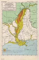
Plate 1 Physiographic Map Central Gulf Coast Plain.
List No
15845.001
Author
[Fisk, Harold N., 1908-1964, Mississippi River Commission]
Full Title
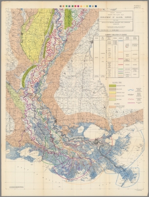
Plate 2 Sheet 1 Alluvial Valley of the Mississippi River. Development of the Alluvial Surface.
List No
15845.002
Author
[Fisk, Harold N., 1908-1964, Mississippi River Commission]
Full Title
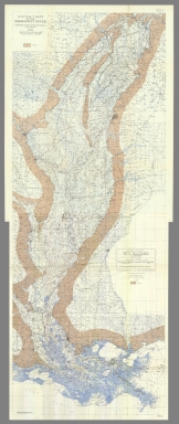
Plate 2 Sheet 2 Alluvial Valley of the Mississippi River. Development of the Alluvial Surface.
List No
15845.003
Author
[Fisk, Harold N., 1908-1964, Mississippi River Commission]
Full Title
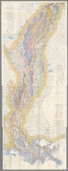
(Composite map of) Plate 2 Sheets 1-2 Alluvial Valley of the Mississippi River. Development of the Alluvial Surface.
List No
15845.004
Author
[Fisk, Harold N., 1908-1964, Mississippi River Commission]
Full Title
Plate 3 Sheet 1 Alluvial Valley of the Mississippi River. Entrenched Valley System.
List No
15845.005
Author
[Fisk, Harold N., 1908-1964, Mississippi River Commission]
Full Title
Plate 3 Sheet 2 Alluvial Valley of the Mississippi River. Entrenched Valley System.
List No
15845.006
Author
[Fisk, Harold N., 1908-1964, Mississippi River Commission]
Full Title
(Composite map of) Plate 3 Sheets 1-2 Alluvial Valley of the Mississippi River. Entrenched Valley System.
List No
15845.007
Author
[Fisk, Harold N., 1908-1964, Mississippi River Commission]
Full Title
Plate 10 Sheet 1 Alluvial Valley of the Mississippi River. Geological Map Alluvial Valley Floor.
List No
15845.008
Author
[Fisk, Harold N., 1908-1964, Mississippi River Commission]
Full Title
Plate 10 Sheet 2 Alluvial Valley of the Mississippi River. Geological Map Alluvial Valley Floor.
List No
15845.009
Author
[Fisk, Harold N., 1908-1964, Mississippi River Commission]
Full Title
(Composite map of) Plate 10 Sheets 1-2 Alluvial Valley of the Mississippi River. Geological Map Alluvial Valley Floor.
List No
15845.010
Author
[Fisk, Harold N., 1908-1964, Mississippi River Commission]
Full Title
Plate 12 Sheet 1 Alluvial Valley of the Mississippi River. Top of Graveliferous Alluvium.
List No
15845.011
Author
[Fisk, Harold N., 1908-1964, Mississippi River Commission]
Full Title
Plate 12 Sheet 2 Alluvial Valley of the Mississippi River. Top of Graveliferous Alluvium.
List No
15845.012
Author
[Fisk, Harold N., 1908-1964, Mississippi River Commission]
Full Title
(Composite map of) Plate 12 Sheets 1-2 Alluvial Valley of the Mississippi River. Top of Graveliferous Alluvium.
List No
15845.013
Author
[Fisk, Harold N., 1908-1964, Mississippi River Commission]
Full Title
Plate 15 Sheet 1 Alluvial Valley of the Mississippi River. Stream Courses.
List No
15845.014
Author
[Fisk, Harold N., 1908-1964, Mississippi River Commission]
Full Title
Plate 15 Sheet 2 Alluvial Valley of the Mississippi River. Stream Courses.
List No
15845.015
Author
[Fisk, Harold N., 1908-1964, Mississippi River Commission]
Full Title
Plate 15 Sheet 3 Alluvial Valley of the Mississippi River. Stream Courses.
List No
15845.016
Author
[Fisk, Harold N., 1908-1964, Mississippi River Commission]
Full Title
Plate 15 Sheet 4 Alluvial Valley of the Mississippi River. Stream Courses.
List No
15845.017
Author
[Fisk, Harold N., 1908-1964, Mississippi River Commission]
Full Title
(Composite map of) Plate 15 Sheets 1- 4 Alluvial Valley of the Mississippi River. Stream Courses.
List No
15845.018
Author
[Fisk, Harold N., 1908-1964, Mississippi River Commission]
Full Title
Plate 22 Sheet 1 Alluvial Valley of the Mississippi River. Ancient Courses Mississippi River Meander Belt. Cape Girardeau, Mo. - Donaldsonville, LA.
List No
15845.019
Author
[Fisk, Harold N., 1908-1964, Mississippi River Commission]
Full Title
Plate 22 Sheet 2 Alluvial Valley of the Mississippi River. Ancient Courses Mississippi River Meander Belt. Cape Girardeau, Mo. - Donaldsonville, LA.
List No
15845.020
Author
[Fisk, Harold N., 1908-1964, Mississippi River Commission]
Full Title
Plate 22 Sheet 3 Alluvial Valley of the Mississippi River. Ancient Courses Mississippi River Meander Belt. Cape Girardeau, Mo. - Donaldsonville, LA.
List No
15845.021
Author
[Fisk, Harold N., 1908-1964, Mississippi River Commission]
Full Title
Plate 22 Sheet 4 Alluvial Valley of the Mississippi River. Ancient Courses Mississippi River Meander Belt. Cape Girardeau, Mo. - Donaldsonville, LA.
List No
15845.022
Author
[Fisk, Harold N., 1908-1964, Mississippi River Commission]
Full Title
Plate 22 Sheet 5 Alluvial Valley of the Mississippi River. Ancient Courses Mississippi River Meander Belt. Cape Girardeau, Mo. - Donaldsonville, LA.
List No
15845.023
Author
[Fisk, Harold N., 1908-1964, Mississippi River Commission]
Full Title
Plate 22 Sheet 6 Alluvial Valley of the Mississippi River. Ancient Courses Mississippi River Meander Belt. Cape Girardeau, Mo. - Donaldsonville, LA.
List No
15845.024
Author
[Fisk, Harold N., 1908-1964, Mississippi River Commission]
Full Title
Plate 22 Sheet 7 Alluvial Valley of the Mississippi River. Ancient Courses Mississippi River Meander Belt. Cape Girardeau, Mo. - Donaldsonville, LA.
List No
15845.025
Author
[Fisk, Harold N., 1908-1964, Mississippi River Commission]
Full Title
Plate 22 Sheet 8 Alluvial Valley of the Mississippi River. Ancient Courses Mississippi River Meander Belt. Cape Girardeau, Mo. - Donaldsonville, LA.
List No
15845.026
Author
[Fisk, Harold N., 1908-1964, Mississippi River Commission]
Full Title
Plate 22 Sheet 9 Alluvial Valley of the Mississippi River. Ancient Courses Mississippi River Meander Belt. Cape Girardeau, Mo. - Donaldsonville, LA.
List No
15845.027
Author
[Fisk, Harold N., 1908-1964, Mississippi River Commission]
Full Title
Plate 22 Sheet 10 Alluvial Valley of the Mississippi River. Ancient Courses Mississippi River Meander Belt. Cape Girardeau, Mo. - Donaldsonville, LA.
List No
15845.028
Author
[Fisk, Harold N., 1908-1964, Mississippi River Commission]
Full Title
Plate 22 Sheet 11 Alluvial Valley of the Mississippi River. Ancient Courses Mississippi River Meander Belt. Cape Girardeau, Mo. - Donaldsonville, LA.
List No
15845.029
Author
[Fisk, Harold N., 1908-1964, Mississippi River Commission]
Full Title
Plate 22 Sheet 12 Alluvial Valley of the Mississippi River. Ancient Courses Mississippi River Meander Belt. Cape Girardeau, Mo. - Donaldsonville, LA.
List No
15845.030
Author
[Fisk, Harold N., 1908-1964, Mississippi River Commission]
Full Title
Plate 22 Sheet 13 Alluvial Valley of the Mississippi River. Ancient Courses Mississippi River Meander Belt. Cape Girardeau, Mo. - Donaldsonville, LA.
List No
15845.031
Author
[Fisk, Harold N., 1908-1964, Mississippi River Commission]
Full Title
Plate 22 Sheet 14 Alluvial Valley of the Mississippi River. Ancient Courses Mississippi River Meander Belt. Cape Girardeau, Mo. - Donaldsonville, LA.
List No
15845.032
Author
[Fisk, Harold N., 1908-1964, Mississippi River Commission]
Full Title
Plate 22 Sheet 15 Alluvial Valley of the Mississippi River. Ancient Courses Mississippi River Meander Belt. Cape Girardeau, Mo. - Donaldsonville, LA.
List No
15845.033
Author
[Fisk, Harold N., 1908-1964, Mississippi River Commission]
Full Title
(Composite map of) Plate 22 Sheets 1-15 Alluvial Valley of the Mississippi River. Ancient Courses Mississippi River Meander Belt. Cape Girardeau, Mo. - Donaldsonville, LA.
List No
15845.034
Note
To view this map in desktop Google Earth, install Google Earth Pro, download this link and open it in Google Earth by double clicking on the file.
https://rumseygeo.s3.amazonaws.com/15845035mercator2/doc.kml
Author
[Fisher, Joseph R., Planters Peanuts (Firm)]
Full Title
Louisiana : The pelican state -- Arkansas : The wonder state -- Alabama : The cotton state -- Mississippi : The magnolia state.
List No
14374.012
Note
Four views, representing Louisiana, Arkansas, Alabama and Mississippi. Views show examples of the landscape and natural resources. Each view includes an inset map of the state, which marks the location of the capital city with a star. Accompanied by descriptive text, the state flags, seals and flowers: magnolia, apple blossom, goldenrod and magnolia, respectively. The view of each state appears both in color (on top) and in black and white (bottom), the latter inviting coloration. Together, views are 18 x 52 cm, on two sheets 20 x 54 cm.
Author
Cram, George Franklin, 1841-1928
Full Title
Cram's railroad and township map of Louisiana. Published by Geo. F. Cram, proprietor of the Western Map Depot. 262-264, Wabash, Ave. Chicago Ills. 1882
List No
14250.048
Note
Map of Louisiana, showing railroads, county boundaries, cities and towns, drainage and coastline. Political boundary lines in color. Includes a bar scale and a scale statement: Scale 18 miles to an inch. With index numbers along the perimeter, and decorative border. 51 x 42 cm, on sheet 58 x 45 cm.
Author
[Pages, Pierre Marie François, 1748-1793, Bernard, Robert]
Full Title
Carte d'une partie de l'Amerique Septentrionale : qui contient partie de la Nle. Espagne, et de la Louisiane, pour servir aux voyages au tour du Monde et vers les deux Poles, faits par M. de Pages ... ; Benard direxit. (to accompany) Atlas Les voyages de Pages (from ) Pages' Voyages autour du Monde, et vers les deux Poles.
List No
11230.003
Note
Uncolored map, showing part of Louisiana, Texas, the Gulf Coast and Mexico. Showing exploration routes, settlements, villages, missions, and rivers. Relief shown pictorially. Includes legend. Pages accompanied the Spanish Governor of Texas on a Journey from New Orleans to Natchitoches and on to San Antonio by way of the Red River in 1767. The book includes a 15 page account of Texas. Humboldt notes Pages' visit to Saltillo in 1767 in his seminal work on New Spain. The map tracks Pages journey from New Orleans to Acapulco, first up the Red River, then overland, identifying a number of Missions and other settlements and Indian Villages in Texas and Louisiana.
Author
[Seutter, Matthaeus, 1678-1756, Rogg, Gottfried, 1669-1742]
Full Title
Accurata delineatio celeberrimae Regionis Ludovicianae vel Gallice Louisiane ol. Canadae et Floridae Adpellatione in Septemtrionali America Descriptae quae Hodie Nomine Fluminis Mississippi vel St. Louis . . . edita cura et manu Matthaei Seutteri, Chalcog. Augustan. ; Gottfr. Rogg, del. M. Rhein, sc.(inset) "Les costes de la Louisiane depuis la baye de Ascension jusques acelle de S. Joseph.
List No
8155.000
Note
Hand colored map of Seutter's Mississippi Bubble map, depicting the short-lived French financial-colonial scheme masterminded by Scottish financier John Law. Map shows early eighteenth century geography, settlements, and territories in North America focusing on the Mississippi River and the Great Lakes. Relief shown pictorially. Includes historical notes and distant chart. A large inset of the Gulf Coast shows many forts and Indian villages. Elaborate title cartouche, depicts an allegorical, satirical scene of the infamous Mississippi Bubble investment scheme with a female personification of the Mississippi River pouring jewels and riches forth, while she is perched precariously upon a bubble. Cherubs above the cartouche are issuing stock for the company, and another group is blowing bubbles in the foreground surrounded by piles of worthless stocks. In the background, desperate investors climb a small tree and fling themselves out of it, and in the foreground more disconsolate investors wail and bemoan their fates as one tries to impale himself on his sword. Above them, a cherub upends an empty money-bag.
Author
Anville, Jean Baptiste Bourguignon d', 1697-1782
Full Title
Partie occidentale du Canada et septentrionale de la Louisiane avec une partie de la Pensilvanie, Par Le Sr. D'Anville ... A Venise par P. Santini 1775. "Longitude occidentale du premier meridien."
List No
8156.000
Note
Santini's edition of Anville's 1755 map - see our 2603.032, although here as a separate map instead of the Anville formulation as a part of a four sheet map of Canada and Lousiana. Hand colored copper engraving map of the Great Lakes and Upper Mississippi region, extends east to include Lake Ontario, North to James Bay and Southeast to Philadelphia. Shows numerous French forts throughout, along with numerous place and Indian names. Chicagon [sic] is named. Relief shown pictorially. Includes Elaborate title cartouche.
Author
[Darby, William, Melish, John]
Full Title
A Map of the State of Louisiana With Part Of The Mississippi Territory, from Actual Survey By Wm. Darby. Entered ... 8th day of April 1816, by William Darby. Saml. Harrison Sct. Philad. Philadelphia, Published May the 1st 1816, by John Melish.
List No
2444.000
Note
Accompanies Darby's "Geographical Description.." First detailed map of the state after Lafon's maps of 1805 and 1806. Melish used this map in compiling his large U.S. map. Two editions of this map were published in 1816, with later editions of 1818 and 1819 published by J. Olmstead and B. Long. Map is dissected into 8 sections, edged in light blue silk, and backed on linen. Outline color. Folds into a new brown cloth folding case 23x15.5 with "Louisiana W. Darby 1816" stamped in gold on the spine.
Author
[Colton, J. H., Norman, B.M., Persac, A.]
Full Title
Norman's Chart Of The Lower Mississippi River By A. Persac. Published by B.M. Norman, New Orleans, La. 1858. Entered ... 1858 by B.M. Norman ... Louisiana. Engraved, Printed & Mounted By J.H. Colton & Co. New York. (At top) From Natchez to New Orleans.
List No
2752.000
Note
Views; shows Plantations by type; very scarce. In full color; lacks original covers. See our reproduction copy issued by Pelican Press, originally in 1931, and printed by Rand McNally - this reproduction greatly alters the original. Ritzlin catalogue: "Persac was a well known surveyor and landscape painter... the map is quite scarce and normally in poor condition because most copies were used by river pilots to locate plantation landings. Few copies are known in contemporary boards. NUC lists only three copies ... however several copies are located in the south, including one which the Louisiana Supreme Court still uses in land ownership cases." Incredible detail, showing the Plantations on both sides of the river. Four engraved views. Engraved by J.H. Colton. Lacking boards, this copy has some tears at the folds with slight loss at some intersections, some light browning in two areas, but is overall a very good copy. Copies at LSU, Historic New Orleans Collection (504-523-4662). See Antiques Magazine, Nov. 1991 for Persac Article. Norman also published "Norman's New Orleans and Environs" with a map of the city, in 1845 (see our copy).
Author
Appleton, D. & Co.
Full Title
Map of Louisiana. Copyright 1891 by Matthews-Northrup Co. ... Buffalo, New York. (inset) Map of New Orleans. (to accompany) The Library Atlas Of Modern Geography ... New York, D. Appleton And Company 1892. (on upper margin) Louisiana. 67.
List No
0026.177
Note
Color map. Shows county boundaries and county seat, capital, rivers, railways, roads, etc. "Size of type indicates importance of the places". Includes notes. Prime meridians are Greenwich and Washington.
Author
Appleton, D. & Co.
Full Title
Map of New Orleans, Louisiana. Copyright 1891 by Matthews-Northrup Co. ... Buffalo, New York. (to accompany) The Library Atlas Of Modern Geography ... New York, D. Appleton And Company 1892. (on upper margin) New Orleans. 69.
List No
0026.183
Note
Color plan of New Orleans. Shows railways, street car lines, parks, canals, etc. Includes numerical references to Depots, hotels, churches, major buildings, points of interest, parks and cemeteries.
Author
Arbuckle Bros.
Full Title
Territory of Wyoming, Alabama, Louisiana, Kansas. Copyright 1889 Arbuckle Bros. N.Y.
List No
0027.011
Note
Sheet with maps of four states in full color. Wyoming's information includes a long paragraph on Yellowstone National Park, which is noted on the card as well. It is mentioned that in Louisiana, yellow fever epidemics swept through the state in 1853, 1867 and 1878. Each card measures 7.5 x 12.5 cm.
Author
Asher & Adams
Full Title
Asher & Adams' Louisiana and Mississippi. Entered according to Act of Congress in the year 1874 by Asher & Adams ... at Washington. (New York, 1874)
List No
0041.013
Note
Hand col. engraved map. Shows townships, distances along railroads, etc. Prime meridians: Greenwich and Washington.
Author
[Bartholomew, John, Black, Adam & Charles]
Full Title
Mississippi & Lousiana. Published by A. & C. Black. Edinburgh. Printed in Colours by Schenck & Macfariane. Edinburgh. Drawn & Engraved by J. Bartholomew, Edinburgh.
List No
0073.016
Note
States outlined in color. Land tinted.
Author
Bradford, Thomas G.
Full Title
Washington. Louisville and Jeffersonville. New Orleans. Cincinnati. Entered ... 1838, by T.G. Bradford ... Massachusetts.
List No
0089.006
Note
Four city maps in full color. The map of Washington includes numbered locations including the Capitol, the State Department, Departments of War, Navy, and the Treasury, as well as the General Post Office.
Author
Bradford, Thomas G.
Full Title
Louisiana. Entered ... 1838, by T.G. Bradford ... Massachusetts. Engraved by G.W. Boynton.
List No
0089.034
Note
In full color.
Full Title
Carte geographique, statistique et historique de la Louisiane. Louisiane. Grave par B. de Beaupre, Rue de Vaugirard, no. 81, a Paris. Fonderie et Imprimerie de J. Carez. (1825)
List No
0102.031
Note
Hand colored engraved map. Relief shown by hachures. Text and tables at sides and bottom. Prime meridians: Washington and Paris.
Author
Burr, David H., 1803-1875
Full Title
Map of Mississippi, Louisiana & Arkansas Exhibiting the Post Offices, Post Roads, Canals, Rail Roads, &c. By David H. Burr. (Late Topographer to the Post Office.) Geographer to the House of Representatives of the U.S. John Arrowsmith. Entered ... July 10th, 1839, by David H. Burr ... District of Columbia.
List No
0104.009
Note
In full color by county. Postal routes by coach, stage, sulkey, cross, rail roads and canals shown. In 8 sections mounted on linen. Label on back states "No. 9. Mississippi, Louisiana, Arkansas."
Author
[Carey, H. C., Lea, I.]
Full Title
Geographical, Historical, And Statistical Map Of Louisiana. Louisiana. No. 31. Kneass Sc.
List No
0122.026
Note
In full color by county or region surrounded by text.
Author
Colton, G.W.
Full Title
Louisiana. Published By J.H. Colton & Co. No. 172 William St. New York. Entered ... 1854 by J.H. Colton ... New York. No. 33.
List No
0149.039
Note
In full color by county.
Author
Colton, G.W.
Full Title
The City Of Louisville Kentucky. (with) The City Of New Orleans Louisiana. Published By J.H. Colton & Co. No. 172 William St. New York. Entered ... 1855 by J.H. Colton & Co. ... New York. No. 34.
List No
0149.040
Note
In full color. Both cities numbered with no reference tables. The two maps are separate but surrounded by the same decorative border.
Author
Colton, G.W.
Full Title
Colton's Louisiana. Published By J. H. Colton. No. 172 William St. New York.
List No
0151.045
Note
Map showing the county boundaries in color. Prime meridians are Greenwich and Washington D.C.
Author
Colton, G.W.
Full Title
Colton's Louisiana. Published By G. W & C. B. Colton & Co. No. 172 William St. New York.
List No
0152.044
Note
Prime meridians are Washington D.C. and Greenwich.
Author
Colton, G.W.
Full Title
The City of Louisville, Kentucky. The City of New Orleans, Louisiana. Published By J. H. Colton. No. 172 William St. New York.
List No
0152.045
Note
The maps of Louisville & New Orleans are drawn upon the same scale.
Author
Cram, George Franklin
Full Title
New Rail Road and County Map of Arkansas, Louisiana, & Mississippi.
List No
0210.034
Note
Prime meridians Greenwich and Washington.
Author
Finley, Anthony
Full Title
Map of Louisiana Mississippi And Alabama Constructed from the Latest Authorities. D.H. Vance Del. J.H. Young Sc. Philadelphia Published by A. Finley 1826.
List No
0278.009
Note
In full color by county. Statistical information includes state size, population, and number of people in different jobs (agriculture, manufacturing, commerce and militia).
Author
Finley, Anthony
Full Title
Map of Louisiana, Mississippi, and Alabama, Constructed from the Latest Authorities.
List No
0279.013
Author
Finley, Anthony
Full Title
Map of Louisiana, Mississippi, and Alabama. Constructed from the Latest Authorities. D.H. Vance Del., Philadelphia Published by A. Finley 1827. J.H. Young Sc.
List No
0280.009
Note
Relief shown by hachures. Prime meridian Washington. Statistical table for each state. Marshlands along Gulf of Mexico well shown.
Author
Finley, Anthony
Full Title
Louisiana. Young & Delleker Sc. Published by A. Finley, Philada. (to accompany) A New General Atlas Comprising a Complete Set of Maps, representing the Grand Divisions Of The Globe ... Philadelphia: Published by Anthony Finley. 1827.
List No
0282.033
Note
Full color map on sheet 35x27. Prime meridians are Washington and Greenwich. Shows counties, major cities, roads and rivers.
Author
Finley, Anthony
Full Title
Louisiana. Published by A. Finley Philada. Young & Delleker Sc.
List No
0285.029
Note
Full color by county.
Author
Gray, O.W.
Full Title
Gray's Atlas Map of Louisiana.
List No
0310.055
Author
[Gray, Frank A., Gray, O.W.]
Full Title
Gray's New Map of Louisiana by Frank A. Gray. Copyright 1878 by O.W. Gray & Son. (insets) City of New Orleans. The Passes of the Mississippi River.
List No
0312.029
Full Title
Alabama, Mississippi, Louisiana & Arkansas Ter. J.H. Young Sc. (Philadelphia: John Grigg, No. 9 North Fourth Street. 1830)
List No
0315.008
Note
Engraved map. Full hand color. Relief shown pictorially. Prime meridians: Greenwich and Washington. "XXXIII."
Author
Johnson, A.J.
Full Title
Johnson's Arkansas, Mississippi, And Louisiana By Johnson and Ward.
List No
0352.032
Note
Full color by county, with heavy outlines around the state. Prime meridians are Greenwich and Washington D.C. Relief shown by hachures.
Author
Johnson, A.J.
Full Title
Johnson's Arkansas, Mississippi, and Louisiana. Entered ... 1866.
List No
0358.037
Author
Leahy, J.F.
Full Title
(Index to) Leahy's Hotel Guide and Railway Distance Maps. Louisiana.
List No
0425.048
Note
Alphabetical index list of the Hotels of the town with the number of rooms of each, their rates per day and the population of the town. Includes population of the state, Explanation of abbreviation of the railroad of the state, and advertisements.
Author
Leahy, J.F.
Full Title
Leahy's Hotel Guide and Railway Distance Map of the State of Louisiana. Published by American Hotel Register Company. Leahy Build., 228-234 W. Ontario St., Chicago, Ill. Copyrighted by J.F. Leahy, Jan., 1934.
List No
0425.049
Note
Map printed without color. Includes name of the railroad entering the town, and distance between towns.
Author
Johnson, A.J.
Full Title
Johnson's Arkansas, Mississippi, And Louisiana By Johnson and Ward.
List No
0535.030
Note
In full color by county. Relief shown by hachures. Meridians Greenwich and Washington D.C.
Author
Mitchell, Samuel Augustus
Full Title
A New Map Of Louisiana With Its Canals, Roads & Distances from place to place, along the Stage & Steam Boat Routes. (with) New Orleans. Published By S. Augustus Mitchell, N.E. corner of Market & 7th Street Philada., 1846. Entered ... 1846 by H.N. Burroughs ... Pennsylvania.
List No
0537.025
Note
In full color by county with steamboat route distances given.
Author
Mitchell, Samuel Augustus
Full Title
A New Map of Louisiana with its Canals, Roads & Distances from Place to Place along the Stage & Steam Boat Routes. Published By S. Augustus Mitchell. N.E. corner of Market & 7th. Streets. Philada. (inset map) New Orleans.
List No
0545.028
Note
Full color map. Includes explanation chart, and reference to steam boat routes. Prime meridian is Washington D.C. Relief shown by hachures.
Author
Mitchell, Samuel Augustus
Full Title
County Map Of Louisiana, Mississippi, And Arkansas. 28. Entered ... 1860, by S. Augustus Mitchell, Jr. ... Pennsylvania.
List No
0565.019
Note
In full color by county.
Author
Mitchell, Samuel Augustus Jr.
Full Title
Map of Louisiana, Mississippi. And Arkansas. Entered ... 1860 by S. Augustus Mitchell, Jr. ... Pennsylvania.
List No
0572.028
Note
Full color map, showing three states by outline color. Prime meridians are Greenwich and Washington, D.C.
Author
Mitchell, Samuel Augustus Jr.
Full Title
Plan of New Orleans. Entered ... 1860 by S. Augustus Mitchell, Jr. ... Pennsylvania.
List No
0572.029
Note
Full color map.
Author
Mitchell, Samuel Augustus Jr.
Full Title
County map of the States of Arkansas, Mississippi and Louisiana. Drawn and Engraved by W.H. Gamble Philadelphia. Entered ... 1867 by S. Augustus Mitchell, Jr. ... Pennsylvania.
List No
0579.029
Note
Color map by county. Relief shown by hachures. Prime meridians are Greenwich and Washington, D.C.
Author
Mitchell, Samuel Augustus Jr.
Full Title
Plan of New Orleans. Entered ... 1867 by S. Augustus Mitchell, Jr. ... Pennsylvania.
List No
0579.030
Note
Color map, showing roads, railroads, etc.
Author
Mitchell, Samuel Augustus
Full Title
County map of the states of Arkansas, Mississippi and Louisiana. Drawn and engraved by W.H. Gamble, Philadelphia. Entered ... 1879 by S. Augustus Mitchell ... Washington. (1880)
List No
0586.027
Note
Hand colored. Relief shown by hachures. Shows settlements, railroads, rivers, etc. Prime meridians: Greenwich and Washington.
Author
Mitchell, Samuel Augustus
Full Title
Plan of New Orleans. Entered ... 1879 by S. Augustus Mitchell ... Washington. (1880)
List No
0586.028
Note
Hand colored. Shows wards, canals, etc. Oriented with north toward upper right.
Author
Mitchell, Samuel Augustus Jr.
Full Title
County map of the states of Arkansas, Mississippi and Louisiana. Drawn and engraved by W.H. Gamble, Sc. Philadelphia. Copyright by S. Augustus Mitchell 1884.
List No
0592.029
Note
Hand colored. Relief shown by hachures. Shows settlements, railroads, rivers, etc. Prime meridians: Greenwich and Washington.
Author
Mitchell, Samuel Augustus Jr.
Full Title
Plan of New Orleans. Copyright by S. Augustus Mitchell 1884.
List No
0592.030
Note
Hand colored. Shows wards, canals, etc. Oriented with north toward upper right.
Full Title
County map of the states of Arkansas, Mississippi and Louisiana. Copyright 1887 by Wm. M. Bradley & Bro. (1890)
List No
0594.028
Note
Hand colored. Relief shown by hachures. Shows settlements, railroads, rivers, etc. Prime meridians: Greenwich and Washington.
Full Title
Plan of New Orleans. Copyright 1887(?) by Wm. M. Bradley & Bro. (1890)
List No
0594.029
Note
Hand colored. Shows wards, canals, etc. Oriented with north toward upper right.
Author
[Morse, Charles W., Colby, Charles A.]
Full Title
Louisiana.
List No
0623.029
Author
Pike, Zebulon Montgomery
Full Title
The First Part of Captn. Pike's Chart of the Internal Part of Louisiana. See Plate 2d. & References. Reduced and laid down on a Scale of 40 miles to the Inch. By Anthony Nau.
List No
0730.002
Note
A highly detailed map showing topography, rivers, historical information, and personal observations, such as "The Alligators go no farther North." Without color.
Author
Pike, Zebulon Montgomery
Full Title
A Chart of the Internal Part of Louisiana, Including all the hitherto unexplored Countries, lying between the River La Platte of the Missouri on the N: and the Red River on the S: the Mississippi East and the Mountains of Mexico West; with a Part of New Mexico & the Province of Texas by Z.M. Pike Captn. U.S.I.
List No
0730.003
Note
A detailed uncolored map showing the route of the American Exploring Party as well as the route "pursued by the Spaniards going out." Spanish and Indian villages, Spanish and American camps shown as well. The northeast corner of the map includes "Highest Peak" eventually to be known as "Pike's Peak."
Author
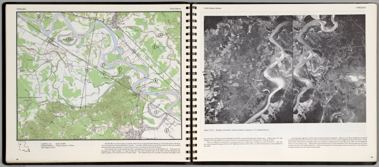
[Scovel, James L., O'Brien, Emmett J]
Full Title
Streams. Fully Mature. Campti, La. (on opposite page) Fully Mature Streams. Stereopair of Red River, vicinity of Campti, Louisiana.
List No
0889.048
Note
Contour map, with text, and location maps. Relief shown by contours and spot heights.
Author
[Scovel, James L., O'Brien, Emmett J]
Full Title
Streams. Delta. new Orleans, La.-Tex.
List No
0889.055
Note
Color maps with text, and location map.
Author
Society for the Diffusion of Useful Knowledge (Great Britain)
Full Title
North America sheet XIII. Parts of Louisiana, Arkansas, Mississippi, Alabama & Florida. Published under the superintendence of the Society for the Diffusion of Useful Knowledge. Engraved by J. & C. Walker. Published June 1st. 1833 by Baldwin & Cradock, 47 Paternoster Row, London. (London: Chapman & Hall, 1844)
List No
0890.140
Note
Engraved map. Relief shown by hachures. County boundaries hand col. Source: Tanner.
Author
Tanner, Henry S.
Full Title
A New Map of Louisiana with Its Roads & Distances from place to place along the Stage & Steam Boat Routes by H.S. Tanner. (inset) New Oreleans.
List No
0976.026
Author
Tanner, Henry S.
Full Title
A New Map Of Louisiana With Its Canals, Roads & Distances from place to place, along the Stage & Steam Boat Routes by H.S. Tanner. (with) New Orleans. Engraved by W. Brose, Philadelphia. Entered ... 1833 by H.S. Tanner ... Pennsylvania. Published by H.S. Tanner No. 144 Chesnut St. Philadelphia. (above neat line) Tanner's Universal Atlas.
List No
0977.021
Note
In full color by county with steamboat routes and distances shown in chart form. Inset map of New Orleans includes districts, buildings and cemeteries.
Author
Tanner, Henry S.
Full Title
A New Map of Louisiana with Its Roads & Distances from place to place along the Stage & Steam Boat Routes by H.S. Tanner. (inset) New Oreleans.
List No
0980.026
Author
[Touring club italiano, Funk & Wagnalls Company.]
Full Title
(Legend to) Stati Uniti, United States of America, Arkansas, Tennessee, Louisiana, Mississippi, Florida, Alabama, Georgia, South Carolina. Propr. Artistico-letteraria del T.C.I. Ufficio cartografico del T.C.I. (1929)
List No
1012CU
Note
Explanation to map.
Author
[Touring club italiano, Funk & Wagnalls Company.]
Full Title
Stati Uniti, United States of America, Arkansas, Tennessee, Louisiana, Mississippi, Florida, Alabama, Georgia, South Carolina. Propr. Artistico-letteraria del T.C.I. Ufficio cartografico del T.C.I. (1929)
List No
1012.078
Note
Color map. Relief shown by hachures and spot heights; depths by isolines. Includes inset of New Orleans at 1:250,000 scale and another that is continuation of main map.
Author
U.S. General Land Office
Full Title
Map of Louisiana. Department of the Interior, General Land Office, October 2nd 1866. Jo. S. Wilson, Commissioner. No. 11. Joseph Gorlinski, Draughtsman, G.L.O.
List No
1070.011
Note
Map in outline color.
Author
U.S. General Land Office
Full Title
(Map 5 - Texas, Lousiana).
List No
1071.007
Note
One of the series of adjacent sixteen maps. Mounted on linen.
Author
U.S. General Land Office
Full Title
(Map 6 - Indian Territory, Arkansas, Mississippi, Alabama, Tennessee, Missouri, Kentucky, Louisiana).
List No
1071.008
Note
One of the series of adjacent sixteen maps. Mounted on linen. Relief shown in hachures.
Author
U.S. General Land Office
Full Title
Department of the Interior, General Land Office. S.S. Burdett, Commissioner. State of Louisiana. 1876. Compiled from the official records of the General Land Office and other sources by C. Roeser, Principal Draughtsman G.L.O. Photolith. & Print by Julius Bien 16 & 18 Park Place, N.Y.
List No
11179.007
Note
Color map. Includes references.
Author
[Zatta, Antonio, active 1757-1797, Zuliani, Giuliano]
Full Title
Il Canada, le colonie inglesi con la Luigiana, e Florida : di nuova projezione. Venezia 1778. Presso Antonio Zatta. G. Zuliani inc. (to accompany) Atlante novissimo ... Tomo IIII. Con privilegio dell Eccelimo Senato. (tomo I-IV).
List No
11598.237
Note
Engraved hand-colored in outline, double-page map of the East coast of America from Nova Scotia to the west of the Mississippi River and Louisiana, including the Great Lakes. Shows political and administrative divisions, cities, towns, coastal towns, mountains and rivers. Relief shown by hachures. includes decorative title cartouche.
Author
Meyer, Joseph, 1796-1856
Full Title
Die Staaten von Arkansas, Mississippi, Louisiana, & Alabama. 1850. (United States of North America). Stahlstich Druck u. Verlag der geographischen Graviranstalt des Bibliographischen Instituts zu Hildburghausen, Amsterdam, Paris und Philadelphia. (in upper margin) Meyer's Zeitung Atlas. No. 67. (to accompany) Neuester Zeitungs-Atlas fur Alte und Neue Erdkunde. Herausgegeben von J. Meyer. (inset) New Orleans
List No
11652.097
Note
Engraved outline hand color map. Shows administrative boundaries, cities and towns. Relief shown by hachures. Prime meridians are Greenwich and Washington.
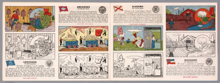
Author
[Aitchison, Robert T., Mentholatum Company]
Full Title
Louisiana: The Pelican State. The romantic epochs of Louisiana history parade before us in picturesque array ... The Mentholatum Company, Wilmington, Delaware. Copyright 1941 R.T. Aitchison.
List No
11722.000
Note
Colorful pictorial promotional map of Louisiana, by R.T. Aitchison, published by the The Mentholatum Company. Map includes decorative vignettes illustrating the history and resources and a detailed text history of the state. Showing place names, roads, railroads, Indian settlements, landmarks, industry and county boundaries. Includes the State seal and The State flower. R.T. Aitchison was a Witchita, Kansas illustrator. His collection is housed at Witchita State University and consists of: 35 maps are divided into two series. The first includes 29 maps by Wichita illustrator and artist Robert T. Aitchison produced for the Mentholatum Company. These include state historical maps, and a map of the Holy Land. The second series includes six maps. These additional maps were not part of the Mentholatum Company series and include maps printed by the McCormick-Armstrong Company, a pencil sketch, a map compiled by Aitchison and rendered by Bill Jackson, and Aitchison's final map finished by Bill Jackson.
Author
[Bellin, Jacques Nicolas, 1703-1772, Depot de la Marine]
Full Title
Carte Reduite des Costes de la Louisiane et de la Floride. (inset) Carte des Embouchures du Fleuve St. Louis.
List No
12059.095
Note
From J.F. Letenneur: "Exceptional onboard document of this rare and fabulous maritime atlas, a masterpiece by the greatest French hydrographer of the 18th century, with maps of all the coastlines known at the time. Bound with the coat of arms of the King of France, the atlas was taken by the English aboard the frigate la Nymphe, off the coasts of Ushant August 10, 1780, during one of the naval battles of the American War of Independence which took place on European waters. In the context of the war at the end of the 18th century, and of the rivalry between the French and British Navy, maritime atlases, were strategic tools, and this “Hydrographie Françoise” more so than any other, because its purpose was to provide the best maritime charts for the French ships that were fighting on the American side against the British. (The handwritten captions throughout most of the atlas are prices for individual maps and all include the same mention: “for sailors”). These atlases were not the kind to be kept in a library, but precious tools, based on the observations of the travelers and continuously improved upon, as reflect in the present copy. It was bound with the engraved title page of the edition of 1737-1765, but the index includes maps printed after 1765 (until 1772), and the copy was augmented by six maps that do not appear in the index (until 1776), as well as 14 pages of text from the Versailles edition of 1773. The later maps are signed by Verdun de la Crenne and were done during the campaigns of the Flore (1771-1772) and of the Isis led by Fleurieu in 1768-1769. The captions explain that the maps were created using the latest technology of the day that could measure longitude (maritime clocks)." (Continued in the Pub Note field).
Author
[Weiland, Carl Ferdinand, 1782 -1847, Hassel, Georg, 1770-1829]
Full Title
Geographisch-statistische und historische Charte von Louisiana.
List No
12293.048
Note
Additional sheet not in bound set.
Author
Anonymous
Full Title
Evangeline Tour (Louisiana). Florida Parishes Tour (Florida).
List No
12335.001
Author
Anonymous
Full Title
A Tourist Map Of Louisiana.
List No
12335.002
Note
Color.
Author
[Gillican, Lucille, Andrew, Louis, Funk & Wagnalls Company.]
Full Title
Vieux Carreede la Nouvelle Orleans over a span of many years. A-Map done in the year 1928, by Lucille Gillican and Louis Andrews. Copyright 1929 by Lucille Gillican
List No
13053.000
Note
A pictorial map of the New Orleans French quarter, drawn in 1028 and published in 1029 by Lucile Gillican and Louis Elizabeth Andrews Fischer. Depicts the New Orleans French Quarter or Vieux Carre highlighting historic buildings and New Orleans culture. At the tope and sides of map: views of places, people, historical notes and landmarks. Library has smaller edition of this map, see Pub list no. 8784.000.
Author
Bache, Alexander D.
Full Title
Cat and Ship Island harbors. From a trigonometrical survey under the direction of A.D. Bache, Superintendent of the Survey of the Coast of the United States. Main triangulation by F.H. Gerdes, assistant. Secondary triangulation by J.E. Hilgard, assistant. Topography by W.E. Greenwell, assistant. Hydrography by the party under the command of C.P. Patterson, Lieut. U.S. Navy. Published in 1850. Reduction for engraving by Chas. Mahon, draughtsman. Engraved by Sherman & Smith, N.Y. Title & sailing directions &c. by J. Knight U.S.C.S. Electrotype copy no. 1 by G. Mathiot, U.S.C.S.
List No
13072.000
Note
Engraved nautical chart, showing hydrographic details of Cat and Ship Island harbors in Mississippi. Relief shown by hachures; depths shown by soundings and isolines. Includes descriptive notes. In upper margin "Presented under authority of an act of Congress of the United States of June 3d 1844 by direction of the Treasury Department, A.D. Bache Superintendent Coast Survey". Includes list of the tides and winds, sailing directions and abbreviations.
Author
Finley, Anthony
Full Title
Louisiana. Young & Delleker Sc. Published by A. Finley Philada. (to accompany) A new general atlas, comprising a complete set of maps, representing the grand divisions of the globe ... 1836.
List No
13379.033
Note
Full color map by administrative divisions.
Author
Stieler, Adolf, 1775–1836
Full Title
Petermann : Vereinigte Staaten Von Nord-Amerika In 6, Bl. 5. Bearbeitet v. H. Habenicht. Gest v. Metzeroth, Eberhardt, Kuhn & Kramer. Stieler's Hand-Atlas No. 85. Gotha: Justus Perthes. 1875.
List No
13563.108
Note
1 outline color map on 6 sheets. Sheet 5. Title from sheet 4. Shows Kansas, Indian Territory, Arkansas, Louisiana and parts of Texas and Missouri.
Author
Stieler, Adolf, 1775–1836
Full Title
Petermann : Vereinigte Staaten Von Nord-Amerika In 6, Bl. 6. Bearbeitet v. H. Habenicht. Gest v. Eberhardt, Kuhn, Metzeroth u. Weiler. Stieler's Hand-Atlas No. 86. Gotha: Justus Perthes. 1875.
List No
13563.109
Note
1 outline color map on 6 sheets. Sheet 6. Title from sheet 4. Inset maps: Der sudlichd theil von Florida. Sudliche theil von Texas. Shows Southern States, Florida, Georgia, Alabama, Tennessee, Kentucky Virginia, North and South Carolina.
Author
[3, Soviet Union. Glavnoe upravlenie geodezii i kartografii]
Full Title
Центральная Часть Юга США = Tsentral'naia Chast' IUga SShA. 239-240. Atlas Mira : 1954.
List No
13682.253
Note
Map of South Central of the United States. Showing state boundaries. Relief shown by shadings, contours and spot heights. Depths shown by gradient tints, isolines and soundings.
Author
[George F. Cram Company collection 1845-1955, National Highways Association]
Full Title
Louisiana. The George F. Cram Company, Chicago. (to accompany) Auto trails and commercial survey of the United States.
List No
13688.039
Note
State of Louisiana. Showing main traveled Highways.
Author
[George F. Cram Company collection 1845-1955, National Highways Association]
Full Title
Louisiana. The George F. Cram Company, Chicago. (to accompany) Auto trails and commercial survey of the United States.
List No
13688.040
Note
State of Louisiana. Showing electric lines in red and administrative boundaries.
Author
Cassini, Gio. Ma. (Giovanni Maria), 1745-approximately 1824
Full Title
(21) La parte occidentale dell'Antico, e Nuovo Messico con la Florida e la lassa Luigiana delineata sulle ultime osservazioni. Roma, presso la Calcografia Camerale, 1798.
List No
14000.192
Note
Relief shown pictorially. Includes decorative title cartouche and bar scales. In Volume III.
Author
Cassini, Gio. Ma. (Giovanni Maria), 1745-approximately 1824
Full Title
(22) La parte orientale dell'Antico, e Nuovo Messico con la Florida e la lassa Luigiana delineata sulle ultime osservazioni. Roma, presso la Calcografia Camerale, 1798.
List No
14000.193
Note
Relief shown pictorially. Includes decorative title cartouche. In Volume III.
Author
Rand McNalley & Company
Full Title
Rand McNally road map : Arkansas -- Louisiana -- Mississippi.
List No
14003.013
Note
Road map of Arkansas, Louisiana and Mississippi, showing interstate and state highways, paved and dirt roads, and ferries, as well as state and national parks. Includes compass rose, time zones, and bar scale with scale statement: One inch equals approximately 26 miles. Features legend indicating population. Copyright by Rand McNally & Company, Chicago, Ill. Lithographed in the U.S.A.
Author
[Bates, Ernest Sutherland, 1879-1939, Schiff, Herman S., Reeves, Norman, Smith, Robert E.]
Full Title
Louisiana, 1812.
List No
14244.045
Note
Pictorial map of Louisiana, showing political boundaries with bordering states and coastline. Features natural resources and manufactured items (including salt, sugar cane, paper and window glass). Includes a compass rose and a scroll listing notable places - such as Capitol at Baton Rouge - which are pictured in vignettes to the right of map, in order of listing. Map is 22 x 24 cm, on sheet 23 x 29 cm. Accompanied by historical text on facing page.
Author
Cram, George Franklin, 1841-1928
Full Title
Louisiana. 1899, by Geo. F. Cram.
List No
14372.176
Note
Map of Louisiana. Shows political boundaries, counties, towns, railroads, steamship lines, topography, marshlands, bodies of water, drainage, coastlines and islands. Relief shown with hachures. Includes key with explanation, latitudinal and longitudinal lines, as well as a bar scale given in miles. With alphanumeric grid corresponding to "Index of Louisiana" on pages 325-327 and 330-331. Colored lithograph. Map is 55 x 41 cm, on double sheet 67 x 45 cm. "Index of maps" and "Index of cities" in margins, providing navigation for atlas as a whole.
Author
Mid-West Map Company
Full Title
Highway map & guide of Louisiana. Mid-West Map Co. Aurora, Mo.
List No
14419.002
Note
Pocket road map for the state of Louisiana. Shows state boundaries, cities, highways, roads, airports, topography, bodies of water, drainage, coastline and islands. Relief shown with hachures. Includes explanatory text, a legend and bar scale given in miles. Indexed, with key on verso. With views: New Vicksburg Bridge -- Pontchartrain Bridge. Advertisements in margins. Printed in blue. Map is 40 x 53 cm, on sheet 44 x 56 cm.
Author
Greenleaf, Jeremiah
Full Title
Louisiana. Illman & Co., sc.
List No
15176.059
Note
Full color by county. Engraved. Relief shown by hachures. Meridians Greenwich and Washington.
Author
Colton, G.W.
Full Title
Colton's Louisiana. Published By G. W & C. B. Colton & Co. No. 182 William St. New York.
List No
1550.040
Note
Prime meridians are Washington D.C. and Greenwich. Shows swamps.
Author
Colton, G.W.
Full Title
The City of Louisville, Kentucky. The City of New Orleans, Louisiana. Published by G. W & C. B. Colton & Co., No. 182 William St. New York.
List No
1550.041
Note
The maps of Louisville & New Orleans are drawn in the same scale.
Author
[Black, Adam, Black, Charles]
Full Title
Mississippi & Louisiana.
List No
1585.069
Author
USSR (Union of Soviet Socialist Republics).
Full Title
206-207. United States of America, South Central. The World Atlas.
List No
1603.218
Author
[Colton, G.W., Fisher, Richard Swainson]
Full Title
Mississippi, Louisiana, and Arkansas. (inset) Vicinity of New Orleans.
List No
1690.090
Note
Relief depicted by hachures. Marshland shown.
Author
[Cram, George, Wood Brothers]
Full Title
Louisiana. (to accompany) The Columbian World's Fair atlas ... Published for: Wood Brothers Cash Store ... Unadilla, New York.
List No
1773.076
Note
Outline hand color map. Shows state and county boundaries, cities and towns. Depth shown by isolines. Prime meridians are Greenwich and Washington.
Author
[Abbot, Henry L., Sigel, Franz, United States. War Department]
Full Title
Map of route and positions, First Corps, Army of Virginia. Major General Sigel, commanding, from August 27th to Sept. 1st 1862. Map of the engagement at Secessionville, James Island, S.C., June 16, 1862. Department of the Gulf, map no. 7. Grand Lake Region. Prepared by order of Maj. Gen. N.P. Banks. Henry L. Abbot ... Feb. 3rd, 1863. (with) Operations of Stuart's cavalry division around Groveton, Aug. 1862. (with) Map of route taken by scouting party under Maj. Gen. J.E.B. Stuart August 1862. Drawn by Wm. W. Blackford ... (with) Map to accompany the report of Maj. Gen. J.E.B. Stuart of the operations of the Cavalry Division during the advance of the Army of Northern Virginia toward the Rappahannock in August 1862. Drawn by Capt. W.W. Blackford ... (with) Map of cavalry expedition to Catlett's Sta., Major General Stuart, commd'g., Aug. 22d. 1862. Drawn by Wm. W. Blackford ... (with) Diagram showing the position of the 3d. Brigade on the battle field, October 3, 1862. (with) Diagram showing the field of battle, October 3rd and 4th, 1862. Julius Bien & Co., Lith., N.Y. (1891-1895)
List No
1780.023
Note
Four col. maps with 6 ancillary maps. Relief shown by hachures; depths by soundings.
Author
United States. War Department
Full Title
Section of map prepared to exhibit the campaigns in which the Army of the Cumberland took part during the War of the Rebellion by order of Maj. Gen. Geo. H. Thomas, U.S.A. Compiled under the direction of Brevt. Maj. Gen. Z.B. Tower ... by Ed. Ruger ... assistants Capt. A. Kilp and Lieut. R. Flach, U.S. Colored Artillery (Heavy) and Asst. Top. Engrs. ... (with) Topographical plan of the city and battle-field of Baton Rouge, La. fought on the 5th of August 1862 drawn by Joseph Gorlinski ... (with) Map of the battle-field of Perryville, Ky ... October 8th 1862. Surveyed and compiled by order of Major General George H. Thomas, U.S.A. (with) Map of the battle-field of Perryville, Ky ... prepared by Walter J. Morris. (with) E. Sketch showing the position of the attacking and defending forces at the Siege of Washington, N.C., March 29 to April 16, 1863. Report of Maj. Gen. J.G. Foster ... Julius Bien & Co., Lith., N.Y. (1891-1895)
List No
1780.024
Note
Col. map with 4 ancillary maps. Relief shown by hachures.
Author
[Merrill, William E., United States. War Department]
Full Title
Vicinity of Decherd. Compiled in the field ... under the direction of Capt. W.E. Merrill ... printed ... by Capt. Margedant's new method for field map printing, July 20th, 1863. Manchester and vicinity ... July 24, 1863. Sketch of Tullahoma, Tenn. and vicinity ... July 6th, 1863. Proposed road along south bank of new canal from Duckport to Walnut Bayou, thence barges towed by Victor to Richmond. Accompanying letter of ... W.T. Sherman ... Jasper and vicinity ... July 24, 1863. Chattanooga and vicinity ... July 20th, 1863. Shelbyville and vicinity. From a survey by Capt. C. Dunham ... July 17th, 1863. Julius Bien & Co., Lith., N.Y. (1891-1895)
List No
1780.035
Note
Seven col. maps. Relief shown by hachures and form lines.
Author
[Matz, Otto H., United States. War Department]
Full Title
Map of the country between Milliken's Bend, La. and Jackson, Miss. showing the routes followed by the Army of the Tennessee under the command of Maj. Gen. U.S. Grant, U.S. Vls. in its march from Milliken's Bend to rear of Vicksburg in April and May 1863. Compiled, surveyed and drawn under the direction of Lt. Col. J.H. Wilson ... Drawn by Maj. Otto H. Matz ... and 1st Lieut. L. Helmle ... Map of the siege of Vicksburg, Miss. by the U.S. forces under the command of Maj. Gen. U.S. Grant ... Maj. F.E. Prime, Chief Engr. Surveyed and constructed under direction of Capt. C.B. Comstock ... by Major Otto H. Matz ..., Chs. Spangenberg ..., Lieuts. Patton, Karnasch and Helmle ..., L. Zwanziger, S.R. Tresilian, B. Barth, S. Hartwell, asst. engrs. Drawn by Chs. Spangenberg ... Julius Bien & Co., Lith., N.Y. (1891-1895)
List No
1780.036
Note
Two col. maps. Relief shown by hachures. Includes "Cross sections and profiles of works shown on Map 2, Siege of Vicksburg, Miss."
Author
[Gillmore, Quincy A., United States. War Department]
Full Title
Galveston, Tex. and its fortifications. Map of siege operations against the defenses of Charleston Harbor, 1863 showing batteries covering the descent upon Morris Island, July 10 and the subsequent operations resulting in the demolition of Ft. Sumter, and the capture of Ft. Wagner and Batty. Gregg, September 7 ... 1863. Q. Gillmore, Major-General commanding and Chief Engineer .... Map of Port Hudson, La. and vicinity. Prepared by order of Major D.C. Houston, Chief Engineer, Department of the Gulf and Captain Peter C. Hains, Corps of Engr's., 1864. Julius Bien & Co., Lith., N.Y. (1891-1895)
List No
1780.038
Note
Three col. maps. Relief shown by hachures; depths by soundings.
Author
[Stevenson, Carter L., United States. War Department]
Full Title
Battle of Lookout Mountain, Tenn., November 24, 1863. Map of the line west of Chattanooga Creek. Accompanying report of Maj. Gen. Carter L. Stevenson, C.S. Army ... (with) Map of country in vicinity of Brown's Ferry. Made to accompany report of Brig. Gen. Wm. F. Smith ... Drawn ... Nov. 5, 1863 by C.S. Mergell. (with) Map of the battle-field of Missionary Ridge showing the positions of Maj. Gen. Sheridan's and Brig. Gen. T.J. Wood's divisions ... Novbr. 23, 24 and 25, 1863 under command of Maj. Gen. Gordon Granger. (with) Map illustrating the positions of the Second Division, Fourth Army Corps, under the command of Maj. Gen. P.H. Sheridan, U.S. Army in front of Chattanooga, Tenn., November 23 to 25, 1863. (with) Chattanooga and vicinity. Accompanying report of Maj. Gen. C.L. Stevenson, C.S. Army. (with) Red River Expedition, 1864. 12th April, 1864, C. Fendall. Accompanying letter of Rear-Admiral D.D. Porter, U.S. Navy. Julius Bien & Co., Lith., N.Y. (1891-1895)
List No
1780.050
Note
Col. map, with 5 ancillary maps. Relief shown by hachures and contours.
Author
United States. War Department
Full Title
Valley of the Red River, La., Mississippi River to Shreveport illustrating the campaign under Major-General N.P. Banks in the spring of 1864, prepared to accompany his report from information furnished by Col. John S. Clark, A.D.C., in the Engineer Bureau, War Department, Jan. 1865, drawn by Theo. von Kamecke. ... Julius Bien & Co., Lith., N.Y. (1891-1895)
List No
1780.052
Note
Col. map in 2 segments. Relief shown by hachures.
Author
Confederate States of America. Army
Full Title
Parts of Arkansas and Louisiana. Respectfully forwarded, Richd. M. Venable ... Accompanying the report of Gen. E. Kirby Smith, C.S. Army. Section including falls and dam in Red River. Prepared by order of B'v't. Brig. Gen. J. Bailey by Lieut. W.S. Trask ... (with) Sketch of the battle-field of Ocean Pond, Fla., February 20th, 1864. M.B. Grant, Lieut., Corps Engrs., C.S.A., del. (with) Part of Louisiana. Sketch of General Liddell's plan, January, 1864. Accompanying letter of Maj. Gen. R. Taylor, C.S. Army. Julius Bien & Co., Lith., N.Y. (1891-1895)
List No
1780.053
Note
Two col. maps with section, and 2 ancillary maps. Relief shown by hachures; depths by soundings. Red River map includes 4 small sections.
Author
[Abbot, Henry L., United States. War Department]
Full Title
Department of the Gulf. Map no. 5. Approaches to New Orleans, prepared by order of Maj. Gen. N.P. Banks (by) Henry L. Abbot, Capt. and Chief Top. Engrs., Feb. 14th, 1863. (with Fairburn, Ga., Aug. 15-16, 1864). (with) Position of Army of Tennessee near Atlanta, Ga., July 22, 1864. (with) Map of Spanish Fort, Ala., made during the siege by Lieut. J.A. Chalaron ... (with) Diagrams illustrating the different positions occupied by the 4th Division, 17th Army Corps, during the battle of Atlanta, Ga., July 22, 1864. (with) Part of Paulding County, showing the position of the Left Wing, 16th A.C., June 4, 1864. (with) Section of a map showing the lines new New Hope Church, Ga., 1864. From Chief Engineer's Office, Army of Mississippi, by Capt. W.J. Morris, Chief Engineer. (with) Topographical sketch of the position of the Second Division, 14th Army Corps, in front of Savannah, Ga., December 11th, 1864. Brig. Gen. Jas. D. Morgan, commanding Division. Surveyed and drawn by Chas. Petri ... (with) Map of the vicinity of Mechanicsville, Va. (with Spanish Fort, Ala., March 29-April 8, 1865. Chas. G. Johnson). (with) Spanish Fort, 1865. Drawn during siege by assistant surgeon Bull, C.S. Army. Julius Bien & Co., Lith., N.Y. (1891-1895)
List No
1780.090
Note
Col. map with 10 ancillary maps. Accompany reports or letters of J. Kilpatrick, Giles A. Smith, J.M. McPherson and T. Seymour.
Author
[Julius Bien & Co., United States. War Department]
Full Title
General topographical map. Sheet XX. Julius Bien & Co., Lith., N.Y. (1891-1895)
List No
1780.158
Note
Col. map. Relief shown by hachures. Shows settlements, railroads, roads, ferries, etc.
Author
[Julius Bien & Co., United States. War Department]
Full Title
General topographical map. Sheet XXI. Julius Bien & Co., Lith., N.Y. (1891-1895)
List No
1780.159
Note
Col. map. Shows settlements, railroads, roads, etc.
Author
[Julius Bien & Co., United States. War Department]
Full Title
General topographical map. Sheet XXII. Julius Bien & Co., Lith., N.Y. (1891-1895)
List No
1780.160
Note
Col. map. Relief shown by hachures. Shows settlements, railroads, roads, etc.
Author
[Julius Bien & Co., United States. War Department]
Full Title
General topographical map. Sheet XXIII. Julius Bien & Co., Lith., N.Y. (1891-1895)
List No
1780.161
Note
Col. map. Relief shown by hachures. Shows settlements, railroads, roads, ferries, etc.
Author
[Cram, George Franklin, Murray-Aaron, Eugene, 1852-1941.]
Full Title
Map of Louisiana. Published by George F. Cram, Chicago, Ill. (to accompany) Cram's atlas of the world, ancient and modern : new census edition -- indexed.
List No
1910.050
Note
In full color on 2 pages. Shows administrative divisions, cities and towns, railroads, roads, rivers, etc. Prime meridian is Greenwich.
Author
Hammond, C.S.
Full Title
Louisiana. 127.
List No
1954.097
Author
Bradstreet Company
Full Title
Louisiana. (to accompany) Bradstreet's Pocket Atlas Of The United States. Published Exclusively for Macullar, Parker & Company, Boston, Massachusetts ... New York: The Bradstreet Company, 1885. (on verso) Entered ... 1879, by The Bradstreet Company ... Washington.
List No
2054.034
Note
Full color map. Prime meridian is Washington, D.C.
Author
Rand McNally and Company
Full Title
(Text Page) Mississippi. Louisiana
List No
2094CR
Note
List of geographical features indexed to map.
Author
Rand McNally and Company
Full Title
Rand, McNally & Co.'s Louisiana.
List No
2094.045
Note
Counties outlined in color. Meridians Washington and Greenwich. Railroads highlighted. Relief shown by hachures.
Author
Rand McNally and Company
Full Title
(Text Page) Louisiana.
List No
2094CS
Note
List of geographical features indexed to map.
Author
Rand McNally and Company
Full Title
(Text Page) Louisiana. Kansas.
List No
2094CT
Note
List of geographical features indexed to map.
Author
Bradford, Thomas G.
Full Title
Louisiana and part of Arkansas. (to accompany) A Comprehensive Atlas, Geographical, Historical & Commercial. By T.G. Bradford. Boston: American Stationers' Company. Entered ... 1835, by Thos. G. Bradford ... Massachusetts.
List No
2120.050
Note
Color map. Shows administrative boundaries, county, cities and towns, rivers, etc. Relief shown pictorially. Prime meridians are Washington and Greenwich.
Author
Bradford, Thomas G.
Full Title
(Text Page to) Louisiana. Arkansas. (to accompany) A Comprehensive Atlas, Geographical, Historical & Commercial. By T.G. Bradford. Boston: American Stationers' Company. Entered ... 1835, by Thos. G. Bradford ... Massachusetts.
List No
2120.051
Note
Text to the General map of Louisiana and Arkansas. Includes population and list of counties.
Full Title
Louisiana. (Published by George F. Cram, Chicago, Ill. 1909)
List No
2134.076
Note
Map in full color. Shows counties, settlements, railroads, etc. Includes index to counties.
Author
Vandermaelen, Philippe, 1795-1869
Full Title
Partie des Etats Unis. Amer. Sep. no. 56. (Dresse par Ph. Vandermaelen, lithographie par H. Ode. Quatrieme partie. - Amer. sept. Bruxelles. 1827)
List No
2212.261
Note
Hand col. lithographed map. Relief shown by hachures. Covers Mississippi and parts of Louisiana, Arkansas, Tennessee, Alabama and Florida.
Author
[Humboldt, Alexander von, 1769-1859, Vandermaelen, Philippe, 1795-1869]
Full Title
Partie du Mexique. Amer. Sep. no. 60. (Dresse par Ph. Vandermaelen, lithographie par H. Ode. Quatrieme partie. - Amer. sept. Bruxelles. 1827)
List No
2212.266
Note
Hand col. lithographed map. Relief shown by hachures. Covers parts of Tamaulipas, Nuevo Leon, Texas and Louisiana. Includes text: Mexique ... de Humboldt.
Author
[Humboldt, Alexander von, 1769-1859, Vandermaelen, Philippe, 1795-1869]
Full Title
Embouchure du Mississipi. Amer. Sep. no. 61. (Dresse par Ph. Vandermaelen, lithographie par H. Ode. Quatrieme partie. - Amer. sept. Bruxelles. 1827)
List No
2212.267
Note
Hand col. lithographed map. Covers also Apalachee Bay area, Florida. Includes "Tableau de la population du Nouveau Monde en l'annee 1825 d'apres Mr. de Humboldt."
Author
Lloyd, H.H.
Full Title
Atlas of the United States. Alabama, Arkansas, Louisiana, and Mississippi. (by H.H. Lloyd. Published by Stedman, Brown & Lyon, Baltimore. 1873)
List No
2239.029
Note
Hand col. lithographed map. Counties in full color.
Author
[Breese, Samuel, 1802-1873, Morse, Sidney E. (Sidney Edwards), 1794-1871]
Full Title
Louisiana. Entered ... 1842 by Sidney E. Morse and Samuel Breese ... New York. (New York: Published by Harper & Brothers, 1845)
List No
2301.032
Note
Col. wax engraved map. Prime meridians: Greenwich and Washington.
Author
[Jones, C.H., Hamilton, T.H., Williams, J.David]
Full Title
Map of South Carolina, Georgia, Florida, Alabama, Mississippi, and Louisiana.
List No
2307.021
Note
Relief shown in hachures.
Author
Poussin, Guillaume Tell, 1794-1876
Full Title
Plan du canal de jonction du Mississippi au Lac Pontchartrain. (with) Canal de Louisville. Profil moyen sur lequel a ete calcule de devis estimatif. (with) Canal de la Chesapeake a la Delaware. Plan du trace, situation des ecluses, nivellement general et profil du canal. Dessine par le Major Poussin. Grave par (V.?) Adam. (1834)
List No
2329.003
Note
Engraved map with 2 insets. Soundings in English feet.
Author
Poussin, Guillaume Tell, 1794-1876
Full Title
Carte generale de la Floride et du Delta du Mississippi, presentant le trace du canal projete de l'Ocean Atlantique au Golfe du Mexique, a travers l'Isthme des Florides, ainsi qui l'ensemble des ameliorations projetees ou en cours d'execution qui one ete recommandees par la Commission des ameliorations interieures pour completer le systeme de navigation interieure parallele a la cote. (with) Entree du Fleuve St. Jean. (with) Entree de la Rade et de la Riviere Ste. Marie. (with) Entree du Port Ste. Augustine. Dessine par le Major Poussin. Grave par (V.?) Adam. (1834)
List No
2329.007
Note
Engraved map with 3 insets. Insets numbered Fig. 1-3. Includes profile in 2 segments.
Author
[Hood, Washington, Poinsett, J.R.]
Full Title
Map Illustrating the Plan of the Defenses of the Western & North-Western Frontier, as Proposed by The Hon: J.R. Poinsettt, Sec. Of War, in his report of Dec. 30, 1837. Compiled in the U.S. Topographical Bureau under the Direction of Col. J.J. Abert, U.S.T.E. By W. Hood.
List No
2392.000
Note
Removed from Poinsett report, 1837. Engraved. Map is without color. Includes Table of distances of the Military posts and depots. On upper right below the neatline reads "2 Session 25 Congress S. No.2 Doc. 65". Prime meridian is Washington.
Author
[Hood, Washington, Gratiot, Charles]
Full Title
Map Illustrating the plan of the defenses of Western & North-Western Frontier, as proposed by Charles Gratiot, in his report of Oct. 31, 1837. Compiled in the U.S. Topographical Bureau under the direction of Col. J.J. Abert, U.S.T.E. By W. Hood.
List No
2393.000
Note
Removed from Poinsett report, 1837. Engraved. Without color.
Author
Colton, G.W.
Full Title
Colton's Louisiana.
List No
2441.081
Author
Bache, A. D.
Full Title
Cat and Ship Island harbors. From a trigonometrical survey under the direction of A.D. Bache, Superintendent of the Survey of the Coast of the United States. Main triangulation by F.H. Gerdes, assistant. Secondary triangulation by J.E. Hilgard, assistant. Topography by W.E. Greenwell, assistant. Hydrography by the party under the command of C.P. Patterson, Lieut. U.S. Navy. Published in 1850. Reduction for engraving by Chas. Mahon, draughtsman. Engraved by Sherman & Smith, N.Y. Title & sailing directions &c. by J. Knight U.S.C.S. Electrotype copy no. 1 by G. Mathiot, U.S.C.S. (with logo) U.S. Coast Survey Office.
List No
2470.043
Note
Engraved nautical chart. Relief shown by hachures; depths by soundings. Includes descriptive notes. In upper margin "Presented under authority of an act of Congress of the United States of June 3d 1844 by direction of the Treasury Department, A.D. Bache Superintendent Coast Survey."
Author
Bache, A. D.
Full Title
Reconnoissance of the passes of the Delta of the Mississippi, Louisiana showing the changes since 1839 by the party under the command of Lieut. B.F. Sands, U.S. Navy & asst. U.S. Coast Survey. U.S. Coast Survey. A.D. Bache, Superintendent. Published in 1852. (with logo) U.S. Coast Survey Office.
List No
2470.044
Note
Four engraved nautical charts on 1 sheet. Contents: (South West Pass) -- (South Pass) -- (Pass a Loutre, N.E. Pass, S.E. Pass) -- Sub-sketch of the Delta of the Mississippi. Scale 1:600,000. Depths shown by soundings. Includes sailing directions. In upper margin "Presented under authority of an act of Congress of the United States of June 3d 1844 by direction of the Treasury Department, A.D. Bache Superintendent Coast Survey."
Author
Mitchell, Samuel Augustus
Full Title
County map of the states of Arkansas, Mississippi and Louisiana. Drawn and engraved by W.H. Gamble, Philadelphia. Entered ... 1870 by S. Augustus Mitchell, Jr. ... Pennsylvania.
List No
2483.025
Note
Hand colored. Shows settlements, railroads, etc. Prime meridians: Greenwich and Washington.
Author
Mitchell, Samuel Augustus
Full Title
Plan of New Orleans. Entered ... 1870 by S. Augustus Mitchell, Jr. ... Pennsylvania.
List No
2483.026
Note
Hand colored. Shows wards, railroads, etc. Oriented with north toward upper right.
Author
Mitchell, Samuel Augustus
Full Title
A New Map of Louisiana. With its Canals, Roads & Distances. From place to place, along Stage & Steam Boat Routes. Published by Charles Desilver, No. 251 Market Street Philadelphia. Entered ... 1856 by Charles Desilver ... Pennsylvania. (inset map) New Orleans.
List No
2514.026
Note
Full color map. Shows state capital, towns, railroads, marshlands, land distance, etc. With table of steam boat routes. Prime meridian is Washington.
Author
Tanner, Henry S.
Full Title
Louisiana and Mississippi By H.S. Tanner. Engraved & Published by H.S. Tanner, Philadelphia. Entered ... 20th day of Decr. 1820, by H.S. Tanner... Pennsylvania. American Atlas.
List No
2589.035
Note
In full color. Numerous notes included about the topography and the height of the rivers in different places along its course.
Author
Tanner, Henry S.
Full Title
Louisiana and Mississippi. Improved to 1825 By H.S. Tanner. Engraved & Published by H.S. Tanner, Philadelphia. Entered ... 20th day of Decr. 1820, by H.S. Tanner... Pennsylvania. American Atlas.
List No
2593.032
Note
In full color. Numerous notes included about the topography and the height of the rivers in different places along its course.
Author
Anville, Jean Baptiste Bourguignon d, 1697-1782
Full Title
Carte de la Louisiane. Par le Sr. d'Anville. Dressee en Mai 1732. Publiee en 1752. (Grave par) Guill? De la Haye.
List No
2603.037
Note
Engraved map on 2 sheets. Includes geographical notes. Relief shown pictorially; depths by soundings. Inset map: Partie superieure de la Louisiane. David Rumsey copy mounted as 1 sheet.
Author
Bradford, Thomas G.
Full Title
Louisiana and part of Arkansas. (to accompany) A Comprehensive Atlas, Geographical, Historical & Commercial. By T.G. Bradford. William D. Ticknor, Boston. Wiley & Long, New-York. Entered ... 1835, by Thos. G. Bradford ... Massachusetts.
List No
2643.050
Note
Outline color map by administrative boundaries. Shows cities and towns, rivers, mountains, etc. Prime meridians are Washington and London.
Author
Finley, Anthony
Full Title
Louisiana. Young & Delleker Sc. Published by A. Finley Philada.
List No
2680.032
Author
[Gray, Ormando Willis, Lloyd, H.H., Walling, H. F.]
Full Title
Atlas of the United States. Alabama, Arkansas, Louisiana, and Mississippi. (Published by Stedman, Brown & Lyon, Cincinnati. 1872. Entered ... 1872, by H.F. Walling, and O.W. Gray, and H.H. Lloyd & Co. ... Washington)
List No
2710.034
Note
Hand col. lithographed map. Counties in full color.
Author
Carey, Mathew
Full Title
Louisiana.
List No
2721.031
Note
Outline color around the State. Great detail shown around the mouth of the Mississippi in contrast to the blank western half of the state. Relief shown by hachures. Prime meridians Philadelphia and London.
Author
Lange, Henry, 1821-1893.
Full Title
Arkansas, Louisiana und Mississippi. H. Lange's Atlas v. Nord Amerika Blatt VI. Braunschweig: Verlag v. George Westermann. Lith. Anst. von L. Kraatz in Berlin.
List No
2743.006
Note
Engraved map. Borders hand col. Shows roads, railroads, swamps, etc. Relief shown by hachures.
Author
Tanner, Henry S.
Full Title
Louisiana And Mississippi By H.S. Tanner. Improved To 1825. American Atlas. Engraved & Published by H.S. Tanner, Philadelphia. Entered ... 20th day of Decr. 1820, by H.S. Tanner ... Pennsylvania.
List No
2755.016
Note
In full color by county or region.
Author
Bachmann, John
Full Title
(Covers to) Panorama of the Seat of War. Birds Eye View Of Louisiana, Mississippi, Alabama And Part Of Florida. John Bachmann, Publisher, 115 & 117 Nassau St., New York. Entered ... 1861 by John Bachmann ... New York. Drawn from Nature and Lith. by John Bachmann.
List No
2780A
Author
Bachmann, John
Full Title
Panorama of the Seat of War. Birds Eye View Of Louisiana, Mississippi, Alabama And Part Of Florida. John Bachmann, Publisher, 115 & 117 Nassau St., New York. Entered ... 1861 by John Bachmann ... New York. Drawn from Nature and Lith. by John Bachmann.
List No
2780.001
Note
Shows entire mouth of the Mississippi. Full color. Bound in black leather covers 38x30 with "Louisiana, Mississippi & Part Of Florida. G.G.W." stamped in gold.
Author
Tanner, Henry S.
Full Title
Louisiana And Mississippi. (engraved by) J. Knight. Sc. (to accompany) A New Pocket Atlas of the United States With The Roads and Distances, Designed For the Use of Travelers. By H.S. Tanner. Philadelphia: Published by the Author. 1828. (on verso) ...on the seventeenth day of November ... 1828, Henry S. Tanner ... hath deposited ... a book ... Pennsylvania.
List No
2782.013
Note
Outline colored map. Prime meridian is Washington, D.C. Rare. Same maps used in Darby's View of U.S. Although this appears in Tanner's catalogues for several years after 1828, it must not have sold well, as few copies have survived. Bound with half leather and paper covered boards. "Pocket Atlas" embossed on spine.
Author
Melish, John
Full Title
Map of New Orleans and Adjacent Country by John Melish. 1815.
List No
2788.012
Note
In outline color with soundings.
Author
Rand McNally and Company
Full Title
Louisiana. (inset) Vicinity of New Orleans.
List No
2790.199
Author
Melish, John
Full Title
Map of New Orleans and Adjacent Country by John Melish 1815.
List No
2803.004
Note
Engraved. Meridians Washington and London.
Author
Cram, George Franklin
Full Title
Louisiana.
List No
2809.047
Note
Locations of banking towns shown by red circles. Railroads are indicated by numbers and colors and patterns, and each railroad has the same number and color and pattern in every state through which it passes. All railroads on each map are in a list keyed to the map. Border of map has a table of contents for the atlas. Relief shown by hachures. Prime meridians Washington D.C. and Greenwich.
Author
Rand McNally and Company
Full Title
(Text Page) Rand, McNally Co.'s Arkansas. Rand, McNally Co.'s Louisiana.
List No
2844CX
Note
Tables of geographical features keyed to map.
Author
Rand McNally and Company
Full Title
Rand, McNally & Co.'s Louisiana. (with) Vicinity of New Orleans.
List No
2844.061
Note
Tables of railroads and chief cities keyed to map.
Author
Rand McNally and Company
Full Title
(Text Page) Rand, McNally Co.'s Louisiana.
List No
2844CY
Note
Tables of geographical features keyed to map.
Author
Rand McNally and Company
Full Title
(Text Page) Rand, McNally Co.'s Louisiana.
List No
2844CZ
Note
Tables of geographical features keyed to map.
Author
Greenleaf, Jeremiah
Full Title
Louisiana. Illman & Co., sc.
List No
2866.055
Note
Full color by county. Engraved. Relief shown by hachures. Meridians Greenwich and Washington.
Author
Johnson, A.J.
Full Title
Johnson's Arkansas Mississippi And Louisiana By Johnson & Browning. No. 31-32.
List No
2905.020
Note
In full color by county.
Full Title
(Map of Mississippi and parts of Louisiana and Arkansas. Raleigh: Branson, Farrar & Co., Publishers. Biblical Recorder Print. 1863)
List No
2915.005
Note
Black and white map. Shows state boundaries, settlements, railroads, etc.
Author
Mitchell, Samuel Augustus
Full Title
(Covers to) Map Of The States Of Louisiana Mississippi & Alabama. Philadelphia: Published by S. Augustus Mitchell. 1835. Sold By Mitchell & Hinman No. 6 North Fifth Street. Entered ... 1834, by S. Augustus Mitchell ... Pennsylvania. J.H. Young Sc.
List No
2991.001
Note
From the Finley 1826 American Atlas, reissued by Mitchell in 1831. Adds steamboat routes and stage routes. As Mitchell issued improved editions of Finley's American Atlas maps, the borders became more elaborate, as is the case here, and the map covers added a more decorative design; covers are black leather 13.5x8.5 with "Mitchell's Map Of Louisiana Alabama & Mississippi" in gilt. Full color. This copy shows many new counties in all three states, roads, etc. when compared with the 1831 edition. Inside the front cover "Census Of 1830" for all three states. Prime meridian is Washington D.C. Relief shown by hachures.
Author
Mitchell, Samuel Augustus
Full Title
Map Of The States Of Louisiana Mississippi & Alabama. Philadelphia: Published by S. Augustus Mitchell. 1835. Sold By Mitchell & Hinman No. 6 North Fifth Street. Entered ... 1834, by S. Augustus Mitchell ... Pennsylvania. J.H. Young Sc.
List No
2991.002
Note
From the Finley 1826 American Atlas, reissued by Mitchell in 1831. Adds steamboat routes and stage routes. As Mitchell issued improved editions of Finley's American Atlas maps, the borders became more elaborate, as is the case here, and the map covers added a more decorative design; covers are black leather 13.5x8.5 with "Mitchell's Map Of Louisiana Alabama & Mississippi" in gilt. Full color. This copy shows many new counties in all three states, roads, etc. when compared with the 1831 edition. Inside the front cover "Census Of 1830" for all three states. Prime meridian is Washington D.C. Relief shown by hachures.
Author
Mitchell, Samuel Augustus
Full Title
Map Of The States Of Louisiana Mississippi & Alabama. Philadelphia: Published by S. Augustus Mitchell. 1835. Sold By Mitchell & Hinman No. 6 North Fifth Street. Entered ... 1834, by S. Augustus Mitchell ... Pennsylvania. J.H. Young Sc.
List No
2991.003
Note
From the Finley 1826 American Atlas, reissued by Mitchell in 1831. Adds steamboat routes and stage routes. As Mitchell issued improved editions of Finley's American Atlas maps, the borders became more elaborate, as is the case here, and the map covers added a more decorative design; covers are black leather 13.5x8.5 with "Mitchell's Map Of Louisiana Alabama & Mississippi" in gilt. Full color. This copy shows many new counties in all three states, roads, etc. when compared with the 1831 edition. Inside the front cover "Census Of 1830" for all three states. Prime meridian is Washington D.C. Relief shown by hachures.
Author
Fullarton, A. & Co.
Full Title
United States North America According to Calvin, Smith & Tanner. By G.H. Swanston Edinr. The South Central Section Comprising Texas, Louisiana, Mississippi, Arkansas, Western Territory, and part of Missouri. LIX. Engraved by G.H. Swanston Edinburgh. A. Fullarton & Co. Edinburgh, London & Dublin.
List No
3007.060
Note
In full color.
Author
Fullarton, A. & Co.
Full Title
Southern Ports & Harbours in the United States. By J. Bartholomew, F.R.G.S. (with) eight maps. LXa. A. Fullarton & Co. London and Edinburgh.
List No
3007.062
Note
Maps in full color. Eight maps include: (1) Washington. (2) Beaufort Harbour. North Carolina. (3) Charleston Harbour. South Carolina. (4) Mobile Bay. (5) Pensacola Bay. Florida. (6) Key West Island. Florida. (7) Delta of the Mississippi & Environs of New Orleans. (8) Galveston Entrance. Texas.
Author
[Raynal, G.T., Bonne, R.]
Full Title
Carte de la Louisiane, et de la Floride. Par M. Bonne, Ingenieur-Hydrographe de la Marine. (on upper margin) Liv. XVI. : No. 46. (and) 47. (to accompany) Histoire Philosophique et Politique Des Establissements et Du Commerce Des Europeens Dans Les Deux Indes.
List No
3083.062
Note
Detailed map, uncolored copper engraving. With inset: "Suplement". Covers Illinois, Georgia and portions of the Carolinas and Virginia. Relief shown by pictorially. Prime meridians are Ferro and Paris.
Author
[Norman, B.M., Moellhausen, Henry]
Full Title
(Covers to) Norman's New Orleans and Environs: Containing a Brief Historical Sketch of the Territory and State of Louisiana, and the City of New Orleans, From the Earliest Period to the Present Time ... With a Correct and Improved Plan of the City ... New Orleans: Published by B.M. Norman. ... 1845. (on verso) Entered ... 1845, by B.M. Norman ... New York.
List No
3413.001
Note
Map is "Norman's Plan of New Orleans & Environs" by Henry Moellhausen. The map was also issued separately in covers (see ad at end of book). Norman published Persac's Chart of the Lower Mississippi River in 1858 (see our copy). Two small maps are included in the text: "New Orleans in 1728" and "Environs of New Orleans." Cloth covered boards with "Norman's New Orleans and Environs" in gilt on cover.
Author
[Norman, B.M., Moellhausen, Henry]
Full Title
Norman's Plan of New Orleans & Environs, 1845 by Henry Moellhausen, Civil Engineer. B.M. Norman, Publisher. Engd. by Shields & Hammond., 2 Camp St., N.O.
List No
3413.002
Note
Map is "Norman's Plan of New Orleans & Environs" by Henry Moellhausen. The map was also issued separately in covers (see ad at end of book). Norman published Persac's Chart of the Lower Mississippi River in 1858 (see our copy). Two small maps are included in the text: "New Orleans in 1728" and "Environs of New Orleans." Cloth covered boards with "Norman's New Orleans and Environs" in gilt on cover.
Author
[Norman, B.M., Moellhausen, Henry]
Full Title
(View of) New - Orleans
List No
3413.003
Note
Map is "Norman's Plan of New Orleans & Environs" by Henry Moellhausen. The map was also issued separately in covers (see ad at end of book). Norman published Persac's Chart of the Lower Mississippi River in 1858 (see our copy). Two small maps are included in the text: "New Orleans in 1728" and "Environs of New Orleans." Cloth covered boards with "Norman's New Orleans and Environs" in gilt on cover.
Author
[Norman, B.M., Moellhausen, Henry]
Full Title
(Title page to) Norman's New Orleans and Environs: Containing a Brief Historical Sketch of the Territory and State of Louisiana, and the City of New Orleans, From the Earliest Period to the Present Time ... With a Correct and Improved Plan of the City ... New Orleans: Published by B.M. Norman. ... 1845. (on verso) Entered ... 1845, by B.M. Norman ... New York.
List No
3413.004
Note
Map is "Norman's Plan of New Orleans & Environs" by Henry Moellhausen. The map was also issued separately in covers (see ad at end of book). Norman published Persac's Chart of the Lower Mississippi River in 1858 (see our copy). Two small maps are included in the text: "New Orleans in 1728" and "Environs of New Orleans." Cloth covered boards with "Norman's New Orleans and Environs" in gilt on cover.
Author
[Norman, B.M., Moellhausen, Henry]
Full Title
New Orleans in 1728
List No
3413.005
Note
Map is "Norman's Plan of New Orleans & Environs" by Henry Moellhausen. The map was also issued separately in covers (see ad at end of book). Norman published Persac's Chart of the Lower Mississippi River in 1858 (see our copy). Two small maps are included in the text: "New Orleans in 1728" and "Environs of New Orleans." Cloth covered boards with "Norman's New Orleans and Environs" in gilt on cover.
Author
[Norman, B.M., Moellhausen, Henry]
Full Title
Environs of New Orleans.
List No
3413.006
Note
Map is "Norman's Plan of New Orleans & Environs" by Henry Moellhausen. The map was also issued separately in covers (see ad at end of book). Norman published Persac's Chart of the Lower Mississippi River in 1858 (see our copy). Two small maps are included in the text: "New Orleans in 1728" and "Environs of New Orleans." Cloth covered boards with "Norman's New Orleans and Environs" in gilt on cover.
Author
Smith, J. Calvin
Full Title
(Texas, Louisiana).
List No
3471.013
Note
Estimated Date. Part of a sixteen piece map combined digitally as a composite in final map of series.
Author
Rand McNally and Company
Full Title
Rand, McNally & Co.'s New business atlas map of Louisiana. Copyright, 1892, by Rand, McNally & Co. (Chicago, 1897)
List No
3565.098
Note
Col. map. Shows townships, etc. Inset: Vicinity of New Orleans. Scale (ca. 1:300,000). Title in margin: Rand, McNally & Company's Indexed atlas of the world. Louisiana.
Author
Rand McNally and Company
Full Title
Rand, McNally & Co.'s indexed atlas of the world map of New Orleans. Rand, McNally & Co's New business atlas map of New Orleans. Copyright, 1892, by Rand, McNally & Co. (Chicago, 1897)
List No
3565.099
Note
Col. map. Shows major buildings, parks, cemeteries, ferries, etc. Includes inset at reduced scale. Title in margin: Indexed atlas of the world.
Author
Mitchell, Samuel Augustus.
Full Title
A new map of Louisiana with its roads & distances from place to place, along the Stage & Steam Boat Routes. Published By S. Augustus Mitchell, N.E. corner of Market & 7th Streets. Philada. 1848. (to accompany) A New Universal Atlas Containing Maps of the various Empires, Kingdoms, States and Republics Of The World. (inset) New Orleans.
List No
3697.028
Note
Color copper lithograph map by county. Shows roads, railroads, capitals, canals, important towns and rivers. Includes explanation and steam boat routes. Prime meridian is Washington.
Author
Colton, G.W.
Full Title
Louisiana (inset) Vicinity of New Orleans.
List No
3800.077
Author
Mitchell, Samuel Augustus
Full Title
A New Map of Louisiana, with its Canals, Roads and Distances from Place to Place, along the Stage & Steam Boat routes. Published by Thomas, Cowperthwait & Co. No. 235 Market Street, Philadelphia. Entered ... 1850, by Thomas, Cowperthwait & Co. ... Pennsylvania. (inset map) New Orleans.
List No
3803.028
Note
Full color map by counties. With steam boat routes, and distances. Explanation showing canals, roads, railroads, capitals, etc. Prime meridian is Washington, D.C.
Author
Mitchell, Samuel Augustus Jr.
Full Title
County map of the States of Arkansas, Mississippi and Louisiana. Drawn and engraved by W.H. Gamble Philadelphia. Entered ... 1874, by S. Augustus Mitchell ... Washington.
List No
3804.029
Note
Hand colored map. Shows settlements, railroads, rivers, etc. Relief shown by hachures. Prime meridians are Greenwich and Washington.
Author
Mitchell, Samuel Augustus Jr.
Full Title
Plan of New Orleans. Entered ... 1874, by S. Augustus Mitchell ... Washington.
List No
3804.030
Note
Hand colored map. Show ward, major public buildings, roads, railroads, etc.
Author
[Johnston, Alexander Keith, 1804-1871, Rogers, Henry Darwin]
Full Title
States Of Mississippi And Louisiana. By Prof. H.D. Rogers & A. Keith Johnston, F.R.S.E. Entered in Sta. Hall. London ... & according to an act of Congress ... 1857, by H.D. Rogers ... Massachusetts. London, John Murray, Albemarle Street, Edinburgh, W. & A.K. Johnston. Engraved by W. & A.K. Johnston, Edinburgh.
List No
3825.017
Note
States and counties in outline color.
Author
[Johnston, Alexander Keith, 1804-1871, Rogers, Henry Darwin]
Full Title
New Orleans. San Francisco. London ... & according to an act of Congress ... 1857, by H.D. Rogers ... Massachusetts. London, John Murray, Albemarle Street, Edinburgh, W. & A.K. Johnston. Engraved by W. & A.K. Johnston, Edinburgh.
List No
3825.030
Note
Full color in water sections, cities with no color.
Author
Mitchell, Samuel Augustus
Full Title
Map of Louisiana, Mississippi And Alabama Constructed from the Latest Authorities. Published by S. Augustus Mitchell Philadelphia. 1831. J.H. Young Sc.
List No
3884.009
Note
Full color by county.
Author
[Gray, Ormando Willis, Colton, G. Woolworth]
Full Title
Lousiana.
List No
3888.030
Note
Prime meridians Washington D.C. and Greenwich. Relief shown by hachures. Both maps have same scale.
Author
National Map Company
Full Title
Louisina. (Copyrighted by) National Map Company, Indianapolis. (to accompany) Official Paved Road and Commercial Survey of the United States.
List No
4048.037
Note
Outline color map. Shows administrative divisions, roads, rivers, etc. Prime meridian is Greenwich.
Author
[Morse, Sidney E. (Sidney Edwards), 1794-1871, Breese, S.]
Full Title
Louisiana. Entered ... 1842, by Sidney E. Morse and Samuel Breese ... New-York. (to accompany) Supplement To The New-York Observer. The Cerographic Atlas Of The United States. By Sidney E. Morse, A.M. And Samuel Breese, A.M. New-York: Published By Sidney E. Morse & Co. 1843.
List No
4180.020
Note
Uncolored map. Shows state capital, county, towns, roads, railroads, rivers, canals, etc. Prime meridian is Washington. Includes explanation.
Author
State Farm Insurance Companies Travel Bureau
Full Title
State Farm Road map: Arkansas, Louisiana - Mississippi. Copyright by Rand McNally & Company, Chicago, Ill. Lithographed in U.S.A. X.3622. (on upper corners) Ark., La., Miss.
List No
4246.014
Note
Color map. Shows roads, points of interest, distances, time zone boundaries, populations, etc. U.S. interstate and principal state highways shown in red. Relief shown by hachures.
Author
Hillebrands, A.J.
Full Title
Atlas de Vereenigde Staten No. 10. Mississippi, Louisiana, en Texas.
List No
4323.012
Note
A scarce small atlas of ten maps published in Holland, but authored by a school teacher from the Dutch Colony in Holland, Michigan. It was most likely sold to Dutch Americans and those in Holland planning to emigrate or who had relatives in America. The date is estimated by Phillips and Koeman. Koeman lists an earlier edition of 1849, with five maps. There is a double page of text at the end of the maps, with lists of distances by steamboat and railroad. The copy listed in Phillips has a cover title, not present here. Maps are hand painted with outline color.
Author
Schonberg & Co.
Full Title
Louisiana. Arkansas.
List No
4324.022
Note
Swamps shown. Relief shown in hachures. Prime meridians are Greenwich and Washington D.C. Counties differentiated by full color.
Author
Mitchell, Samuel Augustus
Full Title
A new map of Louisiana, with its Canals, Roads & Distances, from place to place, along the Stage & Steam Boat Routes. Published by Thomas, Cowperthwait & Co. No. 253 Market Street, Philadelphia. Entered ... 1850 by Thomas, Cowperthwait & Co. ... Pennsylvania. (inset map) New Orleans.
List No
4328.026
Note
Full color map. Shows state capital, railroads, towns, etc. With table of steam boat routes, and distances. Prime meridian is Washington.
Author
Clason Map Company
Full Title
Clason's Road Map of Louisiana. Showing paved roads, All weather roads and other throughfares. (U.S. Highways shown in red.) Published by the Clason Map Co., Denver. Copyrighted Clason Map. All rights reserved. Map No. R-243A.
List No
4423.033
Note
Color map. Includes road legend, and Index of cities and towns giving 1930 Census populations and Key to map.
Author
[Bradford, Thomas G., Goodrich, S.G.]
Full Title
Washington. Louisville and Jeffersonville. New Orleans. Cincinnati. Entered ... 1838 by T.G. Bradford ... Massachusetts.
List No
4453.007
Note
Four maps in full color by area of the city. Washington map numbered with list of references.
Author
[Bradford, Thomas G., Goodrich, S.G.]
Full Title
Louisiana. Engraved by G.W. Boynton. Entered ... 1838, by T.G. Bradford ... Massachusetts.
List No
4453.036
Note
Full color by county or region.
Author
Lloyd, J.T.
Full Title
Lloyd's Map of the Lower Mississippi River From St. Louis To The Gulf Of Mexico. Compiled From Government Surveys In The Topographical Bureau, Washington, D.C. Revised and corrected to the present time by Captains Bart and William Bowen ... Price, in sheets, Colored, 50 Cents per copy. Pocket Edition, $1.00. Mounted Edition on Rollers and Varnished, $1.00 ... J.T. Lloyd, Publisher. 164 Broadway, New York 1863. Entered ... 1862, by J.T. Lloyd ... New York. (on verso) Lloyd's New Map of the United States, The Canadas And New Brunswick ... 1864 ... Entered ... 1863, by J.T Lloyd ... New York. (untitled inset map of Southern Florida).
List No
4472.001
Note
The second edition, Wall map, 5 sections on one sheet, form with Lloyd's New Map of the United States The Canadas and New Brunswick...1864 on the verso. Mapline 28 gives an excellent history of this map and the Bowens' role in making it. It was probably the most detailed map of the Mississippi in the 1860's. Full color. Includes text and explanations.
Author
Lloyd, J.T.
Full Title
Lloyd's New Map of the United States, The Canadas And New Brunswick ... 1864 ... Entered ... 1863, by J.T Lloyd ... New York. (untitled inset map of Southern Florida). (on verso) Lloyd's Map of the Lower Mississippi River From St. Louis To The Gulf Of Mexico. Compiled From Government Surveys In The Topographical Bureau, Washington, D.C. Revised and corrected to the present time by Captains Bart and William Bowen ... Price, in sheets, Colored, 50 Cents per copy. Pocket Edition, $1.00. Mounted Edition on Rollers and Varnished, $1.00 ... J.T. Lloyd, Publisher. 164 Broadway, New York 1863. Entered ... 1862, by J.T. Lloyd ... New York.
List No
4472.002
Note
The second edition, Wall map, 5 sections on one sheet, form with Lloyd's New Map of the United States The Canadas and New Brunswick...1864 on the verso. Mapline 28 gives an excellent history of this map and the Bowens' role in making it. It was probably the most detailed map of the Mississippi in the 1860's. Full color. Includes text and explanations.
Author
Rand McNally and Company
Full Title
Rand, McNally & Co.'s Louisiana.
List No
4520.037
Note
Map in outline color by county. Shows named railroads. Prime meridians: Greenwich and Washington.
Author
Cram, George Franklin
Full Title
Cram's Rail Road & Township Map of Louisiana.
List No
4533.037
Author
Lucas, Fielding Jr.
Full Title
Louisiana. 28. H.S. Tanner, sc. (1816)
List No
4534.028
Note
Engraved, hand colored. Meridian London.
Author
Mitchell, Samuel Augustus
Full Title
A New Map of Lousiana. By J.L. Hazzard. Published By Charles Desilver, No. 714 Chestnut Street, Philadelphia. Entered according to Act of Congress in the year 1857 by Charles Desilver in the Clerk's office if the District Court of the Eastern District of Pennsylvania. 24.
List No
4557.024
Note
Counties tinted in color. Meridians Washington and Greenwich. Swamps shown.
Author
Cram, George Franklin
Full Title
New Rail Road and County Map of Arkansas, Louisiana, & Mississippi.
List No
4558.034
Author
Mitchell, Samuel Augustus Jr.
Full Title
County map of the States of Arkansas, Mississippi, and Louisiana. Drawn and engraved by W.H. Gamble Philadelphia. Entered ... 1876 by S. Augustus Mitchell, . ... Washington. (inset map): Mobile.
List No
4564.030
Note
Full color map by county. Shows settlements, railroads, etc. Covers also parts of New Mexico and Indian Territory. Relief shown by hachures. Prime meridian is Greenwich.
Author
Mitchell, Samuel Augustus Jr.
Full Title
Plan of New Orleans. Entered ... 1876 by S. Augustus Mitchell, . ... Washington.
List No
4564.031
Note
Full color map. Shows wards, canals, etc. Oriented with north toward upper right.
Author
Johnson, A.J.
Full Title
Johnson's Arkansas, Mississippi, and Louisiana. Published by A. J. Johnson, New York. 56. 57. Entered according to the Act of Congress, in the year 1866, by A.J. Johnson in the Clerk's Office of the District Court of the United States for the Southern District of New York.
List No
4574.027
Note
Engraved color map with districts differentiated by color. Shows roads and railroads.
Author
Carey, Mathew
Full Title
Louisiana.
List No
4577.026
Note
Outline color around the State. Great detail shown around the mouth of the Mississippi in contrast to the blank western half of the state.
Author
[Bourquin, Frederick, Mitchell, Samuel Augustus, Tanner, Henry S.]
Full Title
A New Map of Lousiana with its Canals, Roads & Distances. Published by S. Augustus Mitchell, N.E. Corner of Market & 7th. Streets Philada. 1847. Entered according to Act of Congress in the 1846 by H.N. Burroughs - in the Clerk's Office of the Eastern District of Pennsylvania. 24.
List No
4578.025
Note
Lithographed. Canals, roads, railroads, swamps, and rivers shown. Table of distances. Inset of New Orleans with table of buildings keyed to map. Meridian Washington.
Author
Lucas, Fielding Jr.
Full Title
Louisiana. Baltimore. Published by F. Lucas Jr.
List No
4584.066
Note
Full color with miles given in American and Common French Leagues used in Louisiana.
Author
Colton, G.W.
Full Title
Colton's Louisiana. Published By G. W & C. B. Colton & Co. No. 172 William St. New York.
List No
4587.044
Note
Prime meridians are Washington D.C. and Greenwich.
Author
Burr, David H., 1803-1875
Full Title
Louisiana. Illman & Co. Sc. Entered ... 1834 by Thos. Illman ... New York.
List No
4628.055
Note
In full color by county or region.
Author
[Collot, George Henri Victor, Tardieu, P.F.]
Full Title
Plan Of Fort Baton Rouge. Grave par Tardieu l'aine. PL. 35.
List No
4664.025
Note
The only early map of Baton Rouge listed in Phillips. Uncolored with scale in fathoms. Points labeled with numbers and a key are included.
Author
[Collot, George Henri Victor, Tardieu, P.F.]
Full Title
Sketch of new Orleans taken from fort St. Charles. Sketch of Plaquemine Fort. Grave par Tardieu l'aine. PL. 36.
List No
4664.026
Note
Uncolored with no scale markers. The specific forts are noted.
Author
Jefferys, Thomas
Full Title
The Coast of West Florida and Louisiana. By Thos. Jefferys, Geographer to His Majesty. (London, printed for Robt. Sayer, Map & Printseller, no. 53 Fleet Street, as the Act directs 20th Feby. 1775)
List No
4723.009
Note
Engraved nautical chart showing rhumb lines, the Flota's track from Vera Cruz to Havana to avoid the trade winds, currents, etc. Depths shown by soundings and one isoline. Includes notes. Sheet DF.3 of "... a complete chart of the West Indies ..."
Author
Cram, George Franklin
Full Title
Railroad and County Map of Louisiana. Geo. F. Cram. Engraver and Publisher, Chicago.
List No
4727.039
Note
Prime meridians Washington D.C. and Greenwich. Relief shown by hachures. With printed color.
Author
Gray, Ormando Willis
Full Title
Gray's Atlas Map of Louisiana. Gray's Atlas Map of Arkansas.
List No
4740.039
Note
Prime meridians Washington D.C. and Greenwich. Relief shown by hachures. Arkansas map at scale 1:1,431,000.
Author
[Brion de la Tour, Louis, Jefferys, Thomas]
Full Title
Plan of New Orleans the capital of Louisiana; with the disposition of its quarters and canals as they have been traced by Mr. de la Tour in the year 1720. (with) The course of Mississipi River from Bayagoulas to the sea. (with) The east mouth of the Mississipi, with the plan of Fort la Balise which defends the entrance and channel of that river. Nov: 1759, published according to Act of Parliament by T. Jefferys at Charing Cross. Price 2 s.
List No
4796.008
Note
Engraved map with 2 insets. Shows buildings, gardens, lots, magazines, vegetated areas, etc. Scales of inset maps (ca. 1:800,000) and (ca. 1:40,000).
Author
Meyer, Joseph, 1796-1856
Full Title
Neueste Karte von Louisiana mit seinen Canaelen, Strassen, Eisenbahnen, Entfernungen der Hauptpunkte und Routen fur Dampfschiffe. Nach den bessten Quellen verbessert, 1845. (with) New Orleans. Aus der Geographischen Graviranstalt des Bibliographischen Instituts zu Hildburghausen, Amsterdam, Paris u. Philadelphia, (1860)
List No
4807.155
Note
Engraved map. State boundaries hand col. Includes distance tables. Inset map at (ca. 1:28,600) scale. "Meyer's Handatlas No. 69." Prime meridians: Ferro and Washington.
Author
Colton, G.W.
Full Title
Colton's Louisiana. Published by G.W. & C.B. Colton & Co., No. 172 William St. New York.
List No
4825.043
Note
Counties shown in color. Prime meridians are Greenwich and Washington D.C.
Author
Johnson, A.J.
Full Title
Johnson's Arkansas, Mississippi, and Louisiana. Published by Alvin J. Johnson & Co., New York. 56. 57. Entered according to the Act of Congress, in the year 1866, by A.J. Johnson in the Clerk's Office of the District Court of the United States for the Southern District of New York.
List No
4828.041
Note
Engraved color map with districts differentiated by color. Shows roads and railroads.
Author
Johnson, Alvin Jewett, 1827-1884.
Full Title
Johnson's Arkansas, Mississippi, And Louisiana. Published by Alvin J. Johnson & Son, New York. Entered ... 1866, by A.J. Johnson ... New York. (to accompany) Johnson's New Illustrated Family Atlas Of The World ... MDCCCLXXX (1880).
List No
4830.083
Note
Engraved hand colored in outline map on 2 sheets. Shows state and county boundaries, towns, villages, roads, railroads and rivers. Prime meridians are Greenwich and Washington.
Author
Mitchell, Samuel Augustus
Full Title
A New Map of Louisiana. (inset) New Orleans.
List No
4835.033
Author
Greenleaf, Jeremiah
Full Title
Louisiana.
List No
4850.055
Note
Full color county or region.
Author
[Morse, Sidney E. (Sidney Edwards), 1794-1871, Breese, Samuel]
Full Title
Louisiana. Entered ... 1842 by Sidney E. Morse and Samuel Breese ... New York. (New York: Published by Harper & Brothers, 1845). (to accompany) Morse's Cerographic Maps. No. IX.
List No
4861.072
Note
Color wax engraved map. Shows state capital, towns, roads, railroads, canals, etc. Includes explanation. Prime meridians are Greenwich and Washington.
Author
Carey, Mathew
Full Title
Louisiana.
List No
4863.050
Note
Uncolored except for a few islands.
|