|
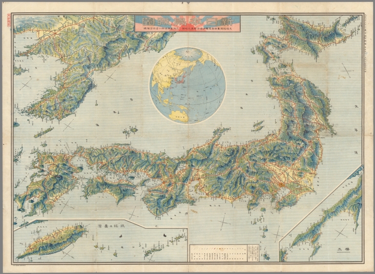
Author
[京城報 ( Gyeongseong Ilbo), Mitarai, Tatsuo]
Full Title
(Covers to) 圖勢現 [Statistical Charts]
List No
15877.001
Note
Shova 16, September 18. and 23. [1941].
Author
[京城報 ( Gyeongseong Ilbo), Mitarai, Tatsuo]
Full Title
(Text page to) 圖勢現 [Statistical Charts]
List No
15877.002
Note
Shova 16, September 18. and 23. [1941].
Author
[京城報 ( Gyeongseong Ilbo), Mitarai, Tatsuo]
Full Title
(1) 圖勢現 [Statistical Charts]
List No
15877.003
Note
Shova 16, September 18. and 23. [1941].
Author
[京城報 ( Gyeongseong Ilbo), Mitarai, Tatsuo]
Full Title
(2-3) 圖勢現 [Statistical Charts]
List No
15877.004
Note
Shova 16, September 18. and 23. [1941].
Author
[京城報 ( Gyeongseong Ilbo), Mitarai, Tatsuo]
Full Title
(4-5) 圖勢現 [Statistical Charts]
List No
15877.005
Note
Shova 16, September 18. and 23. [1941].
Author
[京城報 ( Gyeongseong Ilbo), Mitarai, Tatsuo]
Full Title
(6-7) 圖勢現 [Statistical Charts]
List No
15877.006
Note
Shova 16, September 18. and 23. [1941].
Author
[京城報 ( Gyeongseong Ilbo), Mitarai, Tatsuo]
Full Title
(8-9) 圖勢現 [Statistical Charts]
List No
15877.007
Note
Shova 16, September 18. and 23. [1941].
Author
[京城報 ( Gyeongseong Ilbo), Mitarai, Tatsuo]
Full Title
(10-11) 圖勢現 [Statistical Charts]
List No
15877.008
Note
Shova 16, September 18. and 23. [1941].
Author
[京城報 ( Gyeongseong Ilbo), Mitarai, Tatsuo]
Full Title
(12-13) 圖勢現 [Statistical Charts]
List No
15877.009
Note
Shova 16, September 18. and 23. [1941].
Author
[京城報 ( Gyeongseong Ilbo), Mitarai, Tatsuo]
Full Title
(14-15) 圖勢現 [Statistical Charts]
List No
15877.010
Note
Shova 16, September 18. and 23. [1941].
Author
[京城報 ( Gyeongseong Ilbo), Mitarai, Tatsuo]
Full Title
(16-17) 圖勢現 [Statistical Charts]
List No
15877.011
Note
Shova 16, September 18. and 23. [1941].
Author
[京城報 ( Gyeongseong Ilbo), Mitarai, Tatsuo]
Full Title
(18-19) 圖勢現 [Statistical Charts]
List No
15877.012
Note
Shova 16, September 18. and 23. [1941].
Author
[京城報 ( Gyeongseong Ilbo), Mitarai, Tatsuo]
Full Title
(20-21) 圖勢現 [Statistical Charts]
List No
15877.013
Note
Shova 16, September 18. and 23. [1941].
Author
[京城報 ( Gyeongseong Ilbo), Mitarai, Tatsuo]
Full Title
(22-23) 圖勢現 [Statistical Charts]
List No
15877.014
Note
Shova 16, September 18. and 23. [1941].
Author
[京城報 ( Gyeongseong Ilbo), Mitarai, Tatsuo]
Full Title
(24-25) 圖勢現 [Statistical Charts]
List No
15877.015
Note
Shova 16, September 18. and 23. [1941].
Author
[京城報 ( Gyeongseong Ilbo), Mitarai, Tatsuo]
Full Title
(26-27) 圖勢現 [Statistical Charts]
List No
15877.016
Note
Shova 16, September 18. and 23. [1941].
Author
[京城報 ( Gyeongseong Ilbo), Mitarai, Tatsuo]
Full Title
(28-29) 圖勢現 [Statistical Charts]
List No
15877.017
Note
Shova 16, September 18. and 23. [1941].
Author
[京城報 ( Gyeongseong Ilbo), Mitarai, Tatsuo]
Full Title
(30-31) 圖勢現 [Statistical Charts]
List No
15877.018
Note
Shova 16, September 18. and 23. [1941].
Author
[京城報 ( Gyeongseong Ilbo), Mitarai, Tatsuo]
Full Title
(32-33) 圖勢現 [Statistical Charts]
List No
15877.019
Note
Shova 16, September 18. and 23. [1941].
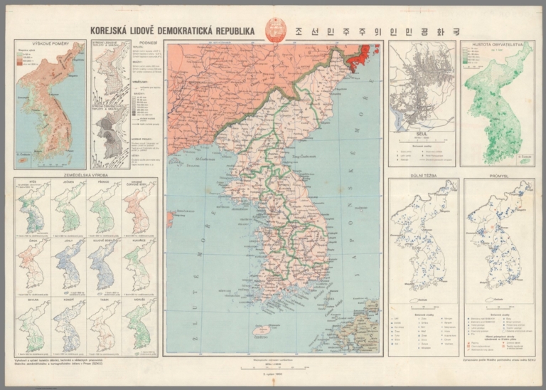
Author
Zaichikov’, V. T.
Full Title
Korea. Soubor Politickych map č.1
List No
15362.002
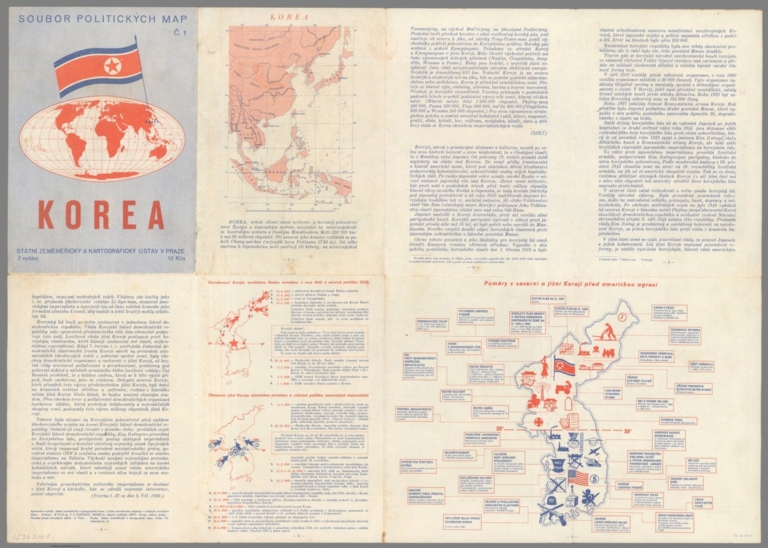
Author
Zaichikov’, V. T.
Full Title
(Text page to) Korea. Soubor Politickych map č.1
List No
15362.003
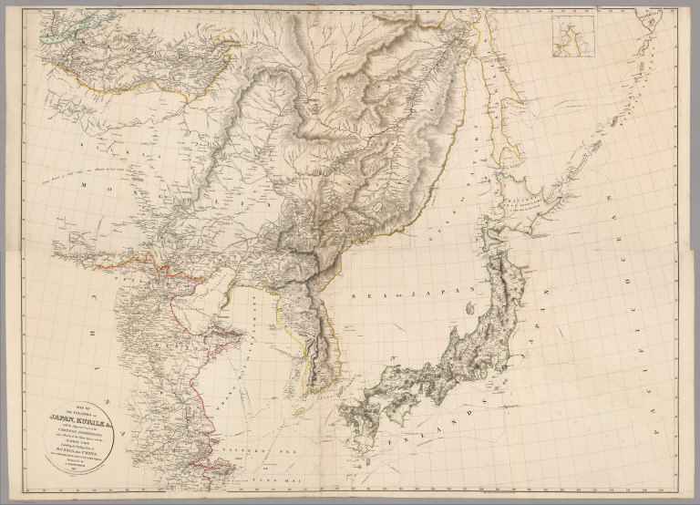
Author
Philip, George, 1870-1937.
Full Title
The Japanese Empire and Korea.
List No
15487.093
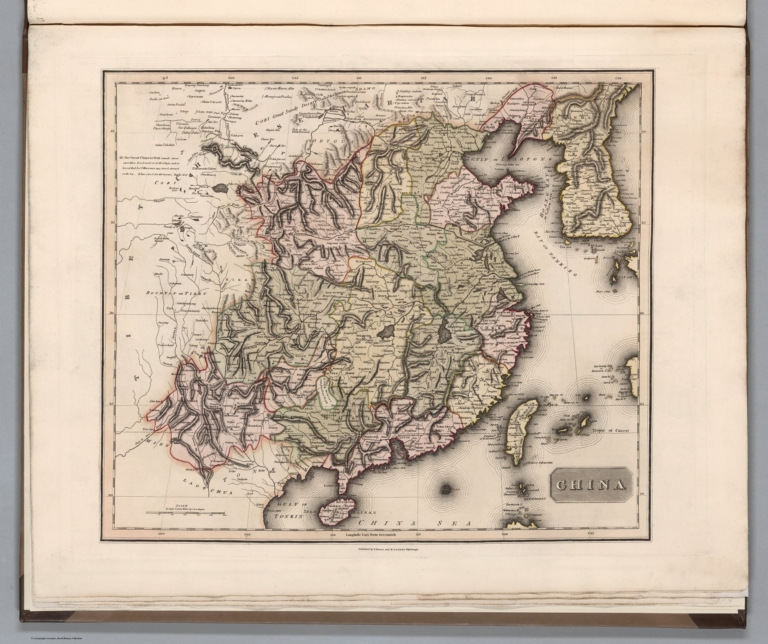
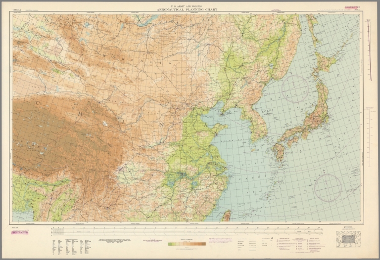
Author
[U.S. Coast and Geodetic Survey, U.S. Army Air Forces]
Full Title
China
List No
15328.003
Author
China History Museum 中国历史博物馆
Full Title
[First Sino-Japanese War. 1894 - 1895.]. 中日战争图. 1894 - 1895年. [Zhong Ri zhan zheng tu. 1894 - 1895 nian].
List No
15078.002
Author
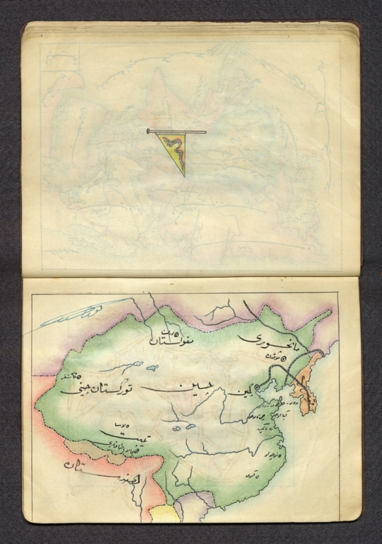
شكوفه مقبل [Şukufe Mukbil]
Full Title
(China and Korea)
List No
10992.025
Note
Dimensions are sheet size.
Author
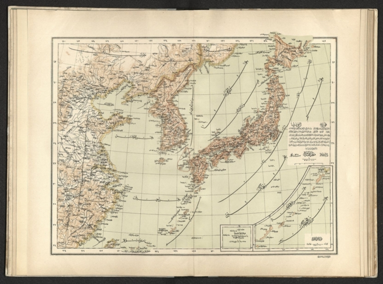
[Pasa, Ali Seref, Esref, Hafiz Ali]
Full Title
Kore; Japonya = Korea; Japan. 1311 (1895). Tabie ve Nnashiri Hasan Ferid. (to accompany) Yeni cografya atlasi - ىگى جغرافىا آطلسى = New geographical atlas. Dersa'adet (Istanbul), 1307-1309 (1891-1893).
List No
13621.027
Note
Map of Korea and Japan, covers East of China. Includes 2 insets: Kuril Islands; Osaka and Hiroshima.
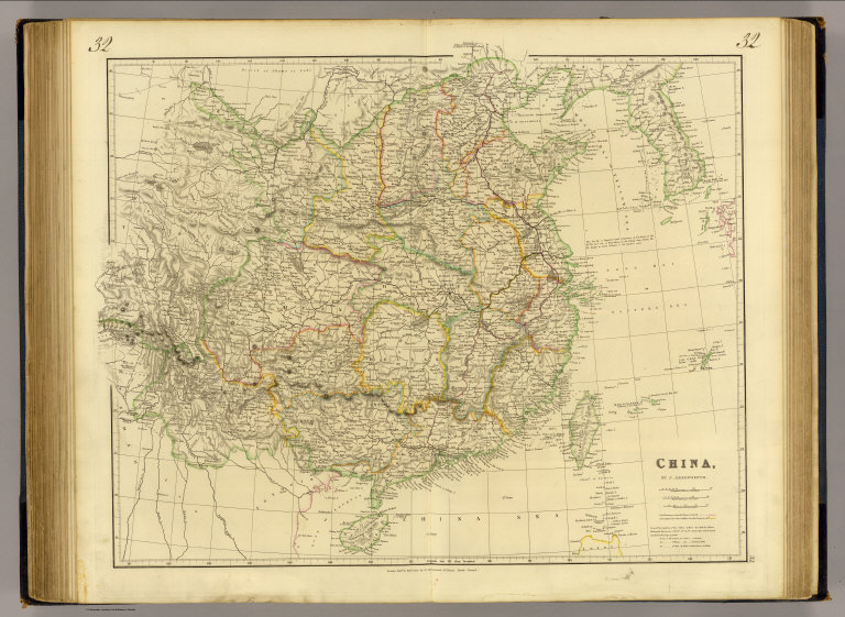
Author
[Lizars, William Home, 1788-1859, Lizars, Daniel]
Full Title
China. Published by T. Brown & W. & D. Lizars, Edinburgh. (to accompany) New Edinburgh general atlas ... The maps drawn and engraved by W. & D. Lizars.
List No
13230.045
Note
Hand colored engraved map, with inset map: Isle of Ceylon. Shows administrative boundaries. Relief shown by hachures and pictorially. Prime meridian is Greenwich.
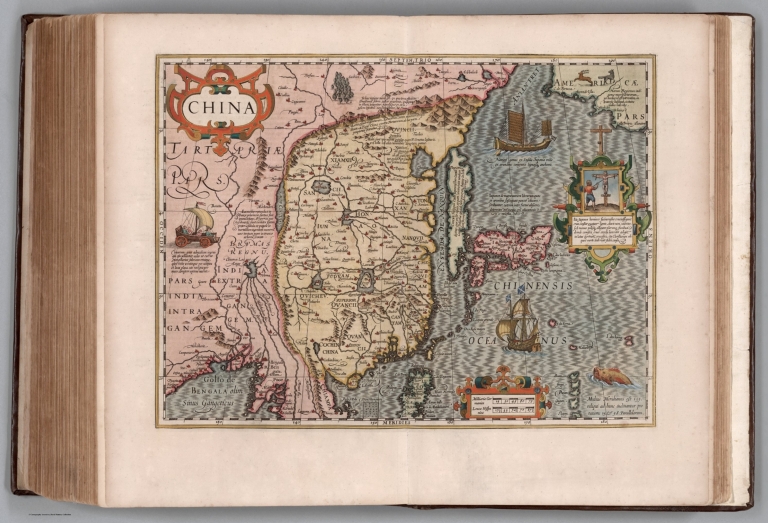
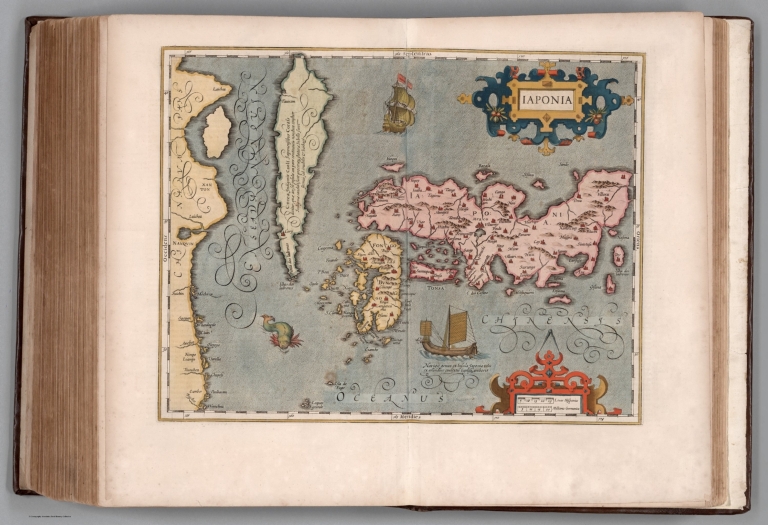
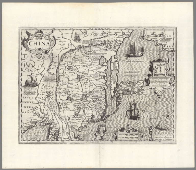
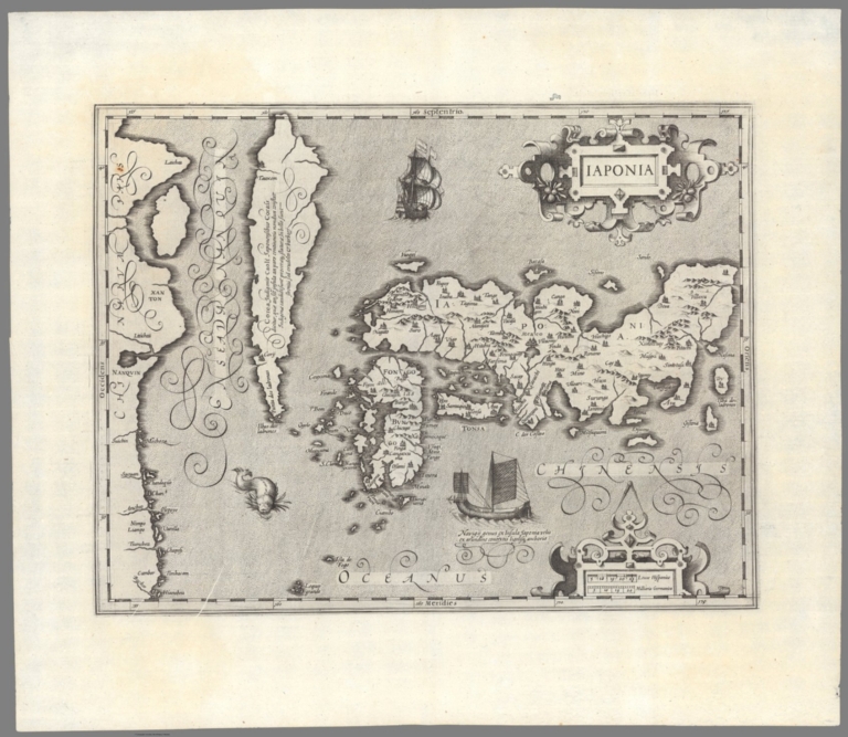
Author
[Mercator, Gerhard, 1512-1594, Hondius, Jodocus, 1563-1612, Hondius, Hendrik, 1597-1651]
Full Title
China.
List No
10534.345
Author
[Mercator, Gerhard, 1512-1594, Hondius, Jodocus, 1563-1612, Hondius, Hendrik, 1597-1651]
Full Title
laponia
List No
10534.351
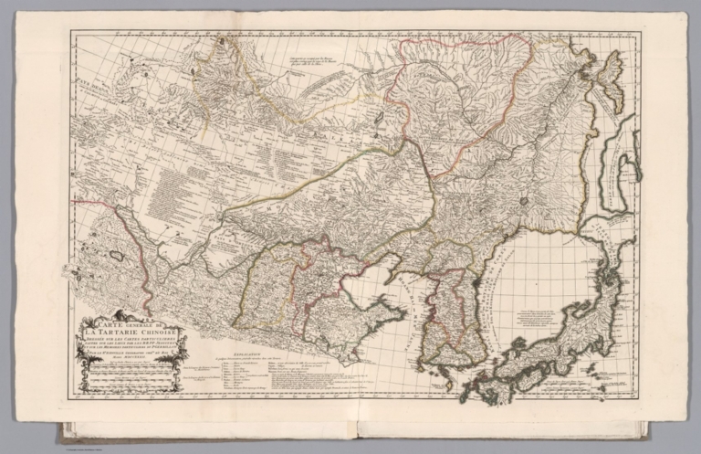
Anville, Jean Baptiste Bourguignon, 1697... Carte generale de la Tartarie Chinoise 1732 13322.027 Related Author
Anville, Jean Baptiste Bourguignon, 1697-1782
Full Title
Carte generale de la Tartarie Chinoise : dressee sur les cartes particulieres faites sur les lieux par les RR PP jesuites et sur les memoires particulieres du P Gerbillon par le Sr. d'Anville, geographe ordre. du Roi Mars MDCCXXXII (1732). (to accompany) Nouvel atlas de la Chine, de la Tartarie chinoise, et du Thibet. Redigees par Mr. d’ Anville. M D CC XXX VII (1737).
List No
13322.027
Note
Hand color outline folded map of the Chinese Tartary region. Covers Korea, Japan and China, centered on Mongolia. Relief shown pictorially. Includes explanation and text.
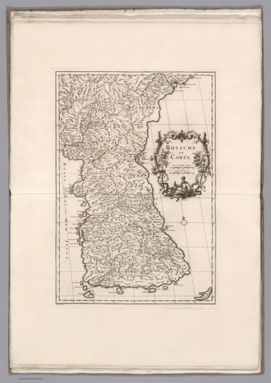
Author
Anville, Jean Baptiste Bourguignon, 1697-1782
Full Title
Royaume de Coree. C. Kondet scrip. (to accompany) Nouvel atlas de la Chine, de la Tartarie chinoise, et du Thibet. Redigees par Mr. d’ Anville. M D CC XXX VII (1737).
List No
13322.030
Note
Engraved map of the Kingdom of Korea. Shows numerous place names. Relief shown pictorially. Includes notes.
Author
[Mercator, Gerhard, 1512-1594, Hondius, Jodocus, 1563-1612]
Full Title
China.
List No
10501.487
Author
[Mercator, Gerhard, 1512-1594, Hondius, Jodocus, 1563-1612]
Full Title
laponia
List No
10501.496
Author
Anonymous
Full Title
(Japan, Korea, and Taiwan.)
List No
8851.000
Note
Date estimated.
Author
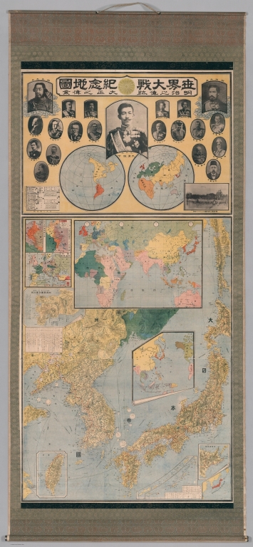
Anonymous
Full Title
(Taisho Japanese map of the world. Taisho Japanese map of Japan and Korea). (9 insets).
List No
11670.000
Note
Wall map of the world commemorating Japanese involvement in World War I on sheet 190x87. Mounted on bamboo rods framed with decorative cloth. In 2 parts: The upper part showing double hemisphere projection map of the world, omitting the Antarctic and any small islands, with numerous portraits of world leaders, most of whom were in power during the first world war. At center is an image of the Japanese Emperor Taisho. The top left corner is an image of someone made to look like Emperor Jimmu, the 1st emperor of Japan. The top right corner is an image of Emperor Meji (1868 – 1912), who preceded Taisho and is known for moving the capitol to Edo (present day Tokyo). Other world leaders shown above the map include King George V (Great Britain) Tsar Nicolas II (Russia), Sultan Mehmed V (Ottoman), Franz Joseph (Austria – Hungary), Woodrow Wilson (United States of America), and Albert I (Belgium), to name a few. The lower part Includes map of Japan and Korea with 9 insets: including map of the world during WWI, map of Taiwan, map of the north extension of Kurile Islands, etc. Includes legend. Date estimated 1918.
Author
Arrowsmith, Aaron
Full Title
(Composite Map of) Map of the Island of Japan, Kurile &c. with the Adjacent Coasts of the Chinese Dominions and a Sketch of the River Amoor and the Baikal Lake Including the Trading Posts of Russia and China and their relative situations with Peking. Delineated by A. Arrowsmith 1811. London, Published by A. Arrowsmith, No. 10 Soho Square, Hydrographer to H.R.H. the Prince of Wales, 4th January, 1811. Additions to 1818.
List No
6733.003
Note
"Large and detailed map of Japan and the northeast coast of Asia.This map is a fine example of Arrowsmith's relentless updating of his maps. First issued in 1811, the map shows the tracks of some of the most important naval expeditions of the late eighteenth and early nineteenth century, which charted the waters around Japan, Korea, North East China, and Russia's Pacific coast. These include those made by La Perouse (1787); HMS 'Hindostan' which carried Lord George Macartney on his embassy to China; Broughton in HMS 'Providence' (1797); and the "track of the Russian's in 1805" - Admiral Krusenstern, who led the first Russian circumnavigation. For this 1818 edition Arrowsmith has also added the the track of HMS 'Alceste', and HC Ship 'Discovery' which, made several voyages around the Yellow Sea in 1816. Arrowsmith most probably drew upon the surgeon aboard the 'Alceste', John McCloed, and his book 'A narrative of a Voyage to the Yellow Sea' (1818), for the most up-to-date information." (Lyon and Turnbull).
Author
Arrowsmith, John
Full Title
China, by J. Arrowsmith. London, pubd. 15 Feby. 1832 by J. Arrowsmith, 35 Essex Street, Strand.
List No
0036.032
Note
Engraved map. Hand colored boundaries. Relief shown by hachures.
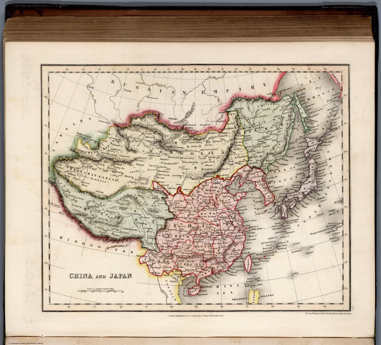
Author
[Dower, John, Higgins, W.M.]
Full Title
China and Japan.
List No
0247.100
La Perouse, Jean-Francois de Galaup, com... Discoveries made in 1787 In the Seas of ... 1799 0414.039 Related Author
La Perouse, Jean-Francois de Galaup, comte de, 1741-1788
Full Title
Chart of Discoveries made in 1787 In the Seas of China and Tartary between Manilla and Avateha by the Boussole & Astrolabe. Published as the Act directs Novr. 1st 1798, by G.G. & J. Robinson, Paternoster Row, London. Neele, sculpt., Strand. No. 39.
List No
0414.039
Note
Engraved. Inset of plan and various views of Necker Island. Meridian Paris.
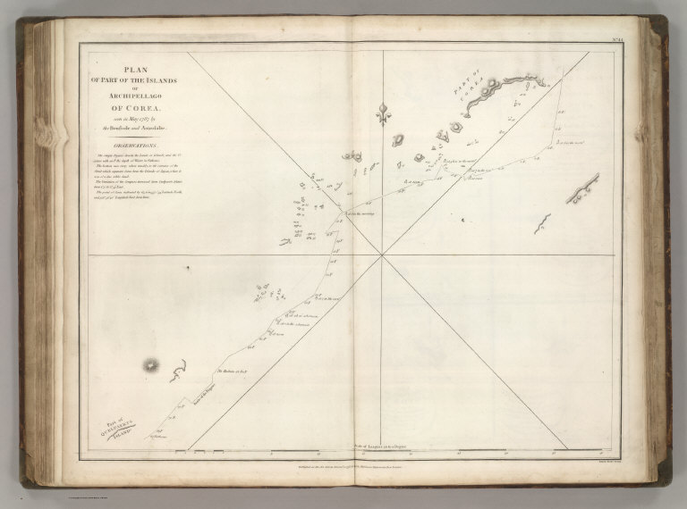
La Perouse, Jean-Francois de Galaup, com... Plan of the Islands or Archipellago of C... 1799 0414.044 Related Author
La Perouse, Jean-Francois de Galaup, comte de, 1741-1788
Full Title
Plan of the Islands or Archipellago of Corea seen in May 1787 by Boussole and Astrolabe. Published as the Act directs Novr. 1st 1798, by G.G. & J. Robinson, Paternoster Row, London. S. Neele sculpt. Strand. No. 44.
List No
0414.044
Note
Engraved. Meridian Paris.
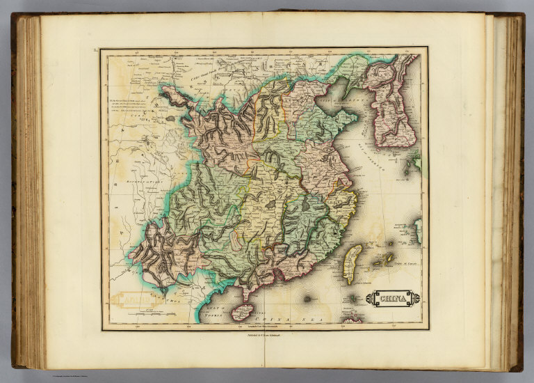
Author
Lizars, Daniel
Full Title
China. Published by D. Lizars, Edinburgh. (1831?)
List No
0436.048
Note
Hand colored engraved map. Relief shown by hachures. Includes Korea.
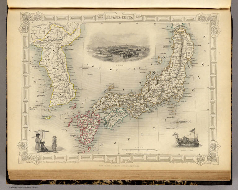
Author
[Martin, R.M., Tallis, J. & F.]
Full Title
Japan & Corea. The Illustrations by H. Warren & Engraved by J.H. Kernot. The Map Drawn & Engraved by J. Rapkin.
List No
0466.047
Note
Countries and regions in outline color with illustrations in black and white of Yedo, a state barge and "Coreans." A geometrically designed borders accented by flowers in the corners.
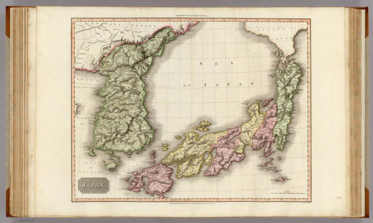
Author
Pinkerton, John, 1758-1826
Full Title
Japan. Drawn under the direction of Mr. Pinkerton by L. Hebert. Neele sculpt. 352 Strand. London: published 1st. March 1809, by Cadell & Davies, Strand & Longman, Hurst, Rees, Orme, & Brown, Paternoster Row.
List No
0732.035
Note
Engraved map. Full hand col. Relief shown by hachures. Covers also Korea. "Pinkerton's modern atlas."
Author
Polish Army Topography Service
Full Title
U.S.S.R. - Far East, Korea, Japan. Pergamon World Atlas. Pergamon Press, Ltd. & P.W.N. Poland 1967. Sluzba Topograficzna W.P.
List No
0737.138
Note
Detailed physical and political map.
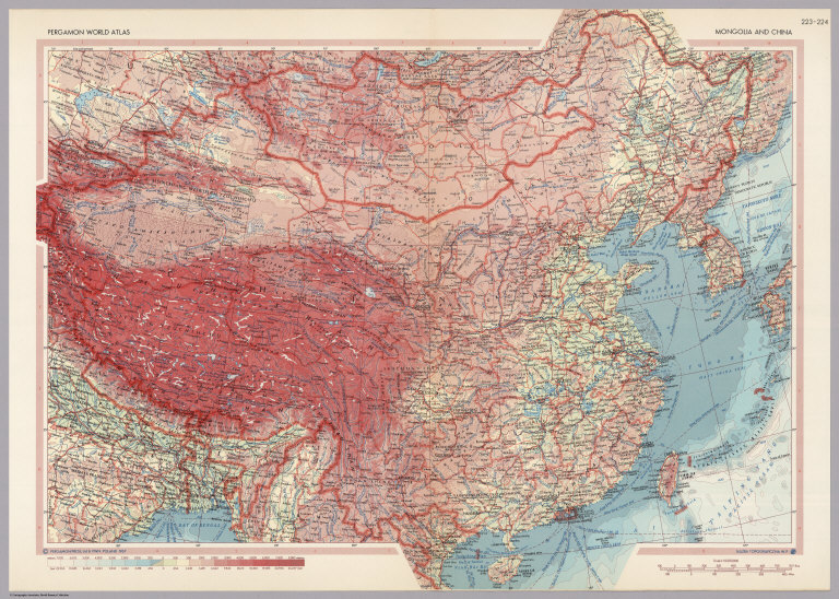
Author
Polish Army Topography Service
Full Title
Mongolia and China. Pergamon World Atlas. Pergamon Press, Ltd. & P.W.N. Poland 1967. Sluzba Topograficzna W.P.
List No
0737.142
Note
Detailed political and physical map.
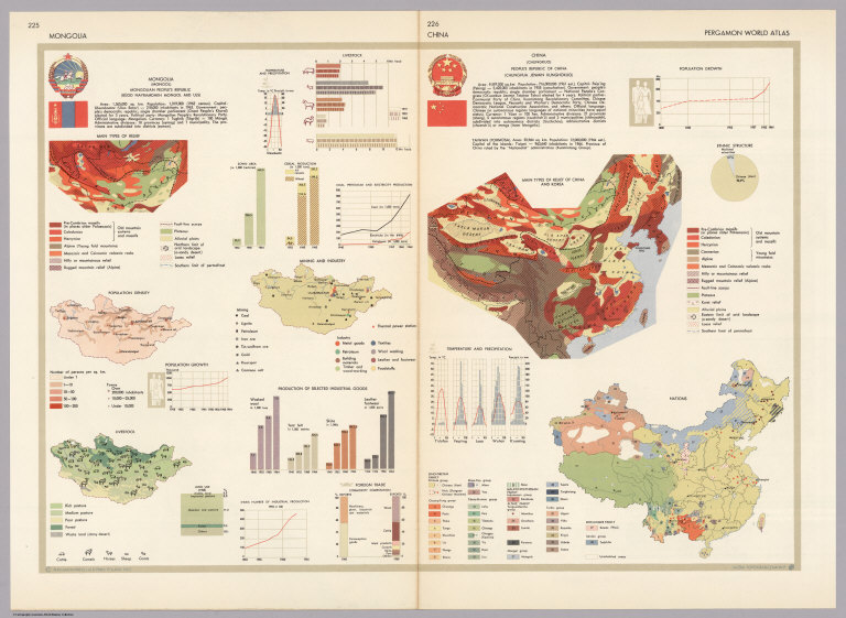
Author
Polish Army Topography Service
Full Title
Mongolia. China. Pergamon World Atlas. Pergamon Press, Ltd. & P.W.N. Poland 1967. Sluzba Topograficzna W.P.
List No
0737.143
Note
Small maps and graphics: thirteen of Mongolia, five of China. Topics include: climate, land use, industrial goods, foreign trade, nations, ethnicity, relief types, livestock, mining, industry, and population.
Author
Polish Army Topography Service
Full Title
Korea. (inset) Cheju-do. Pergamon World Atlas. Pergamon Press, Ltd. & P.W.N. Poland 1967. Sluzba Topograficzna W.P.
List No
0737.148
Note
Detailed political and physical map.
Author
Polish Army Topography Service
Full Title
Korea. Pergamon World Atlas. Pergamon Press, Ltd. & P.W.N. Poland 1967. Sluzba Topograficzna W.P.
List No
0737.149
Note
Fourteen maps and graphics including: industry, population, social structure, land use, agriculture, mining and industry, and foreign trade.
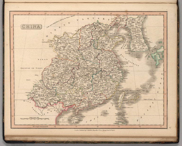
Author
Smith, Charles
Full Title
China.
List No
0908.038
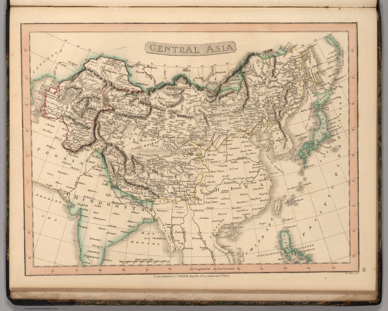
Author
Smith, Charles
Full Title
Central Asia.
List No
0908.039
|
![Covers: 圖勢現 [Statistical Charts]](https://media.davidrumsey.com/MediaManager/srvr?mediafile=/Size3/RUMSEY~8~1/213/15877001.jpg)
![Text: 圖勢現 [Statistical Charts]](https://media.davidrumsey.com/MediaManager/srvr?mediafile=/Size3/RUMSEY~8~1/213/15877002.jpg)
![(1) 圖勢現 [Statistical Charts]](https://media.davidrumsey.com/MediaManager/srvr?mediafile=/Size3/RUMSEY~8~1/213/15877003.jpg)
![(2-3) 圖勢現 [Statistical Charts]](https://media.davidrumsey.com/MediaManager/srvr?mediafile=/Size3/RUMSEY~8~1/213/15877004.jpg)
![(4-5) 圖勢現 [Statistical Charts]](https://media.davidrumsey.com/MediaManager/srvr?mediafile=/Size3/RUMSEY~8~1/213/15877005.jpg)
![(6-7) 圖勢現 [Statistical Charts]](https://media.davidrumsey.com/MediaManager/srvr?mediafile=/Size3/RUMSEY~8~1/213/15877006.jpg)
![(8-9) 圖勢現 [Statistical Charts]](https://media.davidrumsey.com/MediaManager/srvr?mediafile=/Size3/RUMSEY~8~1/213/15877007.jpg)
![(10-11) 圖勢現 [Statistical Charts]](https://media.davidrumsey.com/MediaManager/srvr?mediafile=/Size3/RUMSEY~8~1/213/15877008.jpg)
![(12-13) 圖勢現 [Statistical Charts]](https://media.davidrumsey.com/MediaManager/srvr?mediafile=/Size3/RUMSEY~8~1/213/15877009.jpg)
![(14-15) 圖勢現 [Statistical Charts]](https://media.davidrumsey.com/MediaManager/srvr?mediafile=/Size3/RUMSEY~8~1/213/15877010.jpg)
![(16-17) 圖勢現 [Statistical Charts]](https://media.davidrumsey.com/MediaManager/srvr?mediafile=/Size3/RUMSEY~8~1/213/15877011.jpg)
![(18-19) 圖勢現 [Statistical Charts]](https://media.davidrumsey.com/MediaManager/srvr?mediafile=/Size3/RUMSEY~8~1/213/15877012.jpg)
![(20-21) 圖勢現 [Statistical Charts]](https://media.davidrumsey.com/MediaManager/srvr?mediafile=/Size3/RUMSEY~8~1/213/15877013.jpg)
![(22-23) 圖勢現 [Statistical Charts]](https://media.davidrumsey.com/MediaManager/srvr?mediafile=/Size3/RUMSEY~8~1/213/15877014.jpg)
![(24-25) 圖勢現 [Statistical Charts]](https://media.davidrumsey.com/MediaManager/srvr?mediafile=/Size3/RUMSEY~8~1/213/15877015.jpg)
![(26-27) 圖勢現 [Statistical Charts]](https://media.davidrumsey.com/MediaManager/srvr?mediafile=/Size3/RUMSEY~8~1/213/15877016.jpg)
![(28-29) 圖勢現 [Statistical Charts]](https://media.davidrumsey.com/MediaManager/srvr?mediafile=/Size3/RUMSEY~8~1/213/15877017.jpg)
![(30-31) 圖勢現 [Statistical Charts]](https://media.davidrumsey.com/MediaManager/srvr?mediafile=/Size3/RUMSEY~8~1/213/15877018.jpg)
![(32-33) 圖勢現 [Statistical Charts]](https://media.davidrumsey.com/MediaManager/srvr?mediafile=/Size3/RUMSEY~8~1/213/15877019.jpg)

![[First Sino-Japanese War. 1894 - 1895.]. 中日战争图. 1894 - 1895年. [Zhong Ri zhan zheng tu. 1894 - 1895 nian].](https://media.davidrumsey.com/MediaManager/srvr?mediafile=/Size3/RUMSEY~8~1/199/15078002.jpg)