|
Author
[Fisher, Joseph R., Planters Peanuts (Firm)]
Full Title
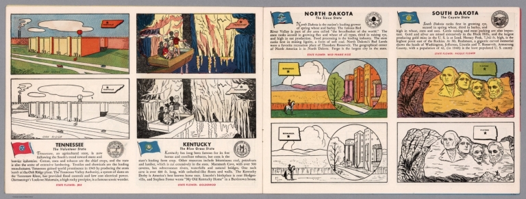
Tennessee : The volunteer state -- Kentucky : The blue grass state -- North Dakota : The Sioux state -- South Dakota : The coyote state.
List No
14374.013
Note
Four views, representing Tennessee, Kentucky, North Dakota and South Dakota. Views show examples of the landscape and natural resources. Each view includes an inset map of the state, which marks the location of the capital city with a star. Accompanied by descriptive text, the state flags, seals and flowers: iris, goldenrod, wild prairie rose and pasque flower, respectively. The view of each state appears both in color (on top) and in black and white (bottom), the latter inviting coloration. Together, views are 18 x 52 cm, on two sheets 20 x 54 cm.
Author
Cram, George Franklin, 1841-1928
Full Title
Railroad and county map of Kentucky and Tennessee. Geo. F. Cram, engraver and publisher, Chicago.
List No
14250.040
Note
Map of Kentucky and Tennessee, showing railroads (both finished and unfinished), county boundaries, cities and towns, and drainage. Political boundary lines in color. Includes a legend. With index numbers along the perimeter, and decorative border. Also, with hand-drawn annotations tracing routes of travel across landscapes where no official transit appears. 39 x 55 cm, on sheet 45 x 58 cm.
Author
Appleton, D. & Co.
Full Title
Map of Kentucky and Tennessee. Copyright 1891 by Matthews-Northrup Co. ... Buffalo, New York. (to accompany) The Library Atlas Of Modern Geography ... New York, D. Appleton And Company 1892. (on upper margin) Kentucky and Tennessee. 66.
List No
0026.173
Note
Color map. Shows county boundaries and county seat, capital, railways, roads, etc. "Size of type indicates importance of the places". Includes notes. Prime meridians are Greenwich and Washington.
Author
Asher & Adams
Full Title
Asher & Adams' Kentucky & Tennessee. Entered according to Act of Congress in the year 1874 by Asher & Adams ... at Washington. (New York, 1874)
List No
0041.012
Note
Hand col. engraved map. Relief shown by hachures. Shows townships, distances along railroads, etc. Prime meridians: Greenwich and Washington.
Author
[Bartholomew, John, Black, Adam & Charles]
Full Title
Kentucky and Tennessee. Published by A. & C. Black. Edinburgh. Printed in Colours by Schenck & Macfariane. Edinburgh. Drawn & Engraved by J. Bartholomew, Edinburgh.
List No
0073.012
Note
States outlined in color. Land tinted.
Author
Burr, David H., 1803-1875
Full Title
Map of Kentucky & Tennessee Exhibiting the Post Offices, Post Roads, Canals, Rail Roads, &c. By David H. Burr. (Late Topographer to the Post Office.) Geographer to the House of Representatives of the U.S. John Arrowsmith. Entered ... July 10th, 1839, by David H. Burr ... District of Columbia.
List No
0104.011
Note
In full color by county. Postal routes by coach, stage, sulkey, cross, rail roads and canals shown. In 8 sections mounted on linen. Label on back states "No. 11. Kentucky, Tennessee."
Author
Colton, G.W.
Full Title
Kentucky And Tennessee. Published By J.H. Colton & Co. No. 172 William St. New York. Entered ... 1855 by J.H. Colton & Co. ... New York. No. 38.
List No
0149.043
Note
In full color by county.
Author
Colton, G.W.
Full Title
Colton's Kentucky and Tennessee. Published By J. H. Colton. No. 172 William St. New York.
List No
0151.049
Note
Map showing the county boundaries in color. Prime meridians are Greenwich and Washington D.C.
Author
Colton, G.W.
Full Title
Colton's Kentucky and Tennessee. Published By G. W & C. B. Colton & Co. No. 172 William St. New York.
List No
0152.048
Note
Prime meridians are Washington D.C. and Greenwich.
Author
Cram, George Franklin
Full Title
New Rail Road and County Map of Kentucky & Tennessee.
List No
0210.032
Note
Prime meridians Greenwich and Washington.
Author
Finley, Anthony
Full Title
Map of Kentucky And Tennessee Compiled from the Latest Authorities. D.H. Vance Del. J.H. Young Sculp. Philadelphia Published by A. Finley.
List No
0278.010
Note
In full color by county. Statistical table by state and status (white, free black, slave) in 1790, 1800, 1810, and 1820 given. Occupational status shown for 1820.
Author
Finley, Anthony
Full Title
Map of Kentucky and Tennessee, Constructed from the Latest Authorities.
List No
0279.014
Note
Date estimated.
Author
Finley, Anthony
Full Title
Map of Kentucky and Tennessee, compiled for the Latest Authorities. D.H. Vance Del., Philadelphia Published by A. Finley. J.H. Young Sculp.
List No
0280.010
Note
Relief shown by hachures. Prime meridian Washington. Statistical table for each state.
Author
Finley, Anthony
Full Title
(Covers to) Map of Kentucky And Tennessee Compiled from the Latest Authorities. Philadelphia Published by A. Finley. D.H. Vance Del. J.H. Young Sculp.
List No
0281.001
Note
Appears to be the same state of the map that is found in Finley's American Atlas of 1826. In brown leather covers 15x9 with "Kentucky & Tennessee" in gilt; no date on map. Full color.
Author
Finley, Anthony
Full Title
Map of Kentucky And Tennessee Compiled from the Latest Authorities. Philadelphia Published by A. Finley. D.H. Vance Del. J.H. Young Sculp.
List No
0281.002
Note
Appears to be the same state of the map that is found in Finley's American Atlas of 1826. In brown leather covers 15x9 with "Kentucky & Tennessee" in gilt; no date on map. Full color. Prime meridian is Washington D.C. Relief shown pictorially.
Author
Gray, O.W.
Full Title
Gray's Atlas Map of Kentucky and Tennessee.
List No
0310.058
Author
[Gray, Frank A., Gray, O.W.]
Full Title
Gray's New Map of Kentucky and Tennessee by Frank A. Gray. Copyright 1876 by O.W. Gray & Son. (insets) Outline Map of Kentucky and Tennessee illustrating the System of Railroads. Hyposometric Sketch of Kentucky Tennessee. Outline Map of Kentucky and Tennessee illustrating the Density of Population.
List No
0312.033
Author
Johnson, A.J.
Full Title
Johnson's Kentucky And Tennessee By Johnson and Ward.
List No
0352.034
Note
Full color by county, with heavy outlines around the state. Includes vignettes of the State House in Nashville, the Navy Yard in Memphis, and Entrance to the Mammoth Cave. Prime meridians are Greenwich and Washington D.C. Relief shown by hachures.
Author
Johnson, A.J.
Full Title
Johnson's Kentucky and Tennessee. Entered ... 1865.
List No
0358.039
Author
Leahy, J.F.
Full Title
Leahy's Hotel Guide and Railway Distance Map of the State of Tennessee. Published by American Hotel Register Company. Leahy Build., 228-234 W. Ontario St., Chicago, Ill. Copyrighted by J.F. Leahy, Jan., 1934.
List No
0425.113
Note
Map printed without color. Includes name of the railroad entering the town, and distance between towns.
Author
Johnson, A.J.
Full Title
Johnson's Kentucky And Tennessee By Johnson and Ward.
List No
0535.032
Note
In full color by county. Vignettes of the State House in Nashville, and the Navy Yard in Memphis. Relief shown by hachures. Meridians Greenwich and Washington D.C.
Author
Mitchell, Samuel Augustus
Full Title
County Map Of Kentucky, And Tennessee. 24. Entered ... 1860, by S. Augustus Mitchell, Jr. ... Pennsylvania.
List No
0565.016
Note
In full color by county.
Author
Mitchell, Samuel Augustus Jr.
Full Title
County map of Kentucky, and Tennessee. Entered ... 1860 by S. Augustus Mitchell, Jr. ... Pennsylvania.
List No
0572.025
Note
Full color map by county. Relief shown by hachures. Prime meridians are Greenwich and Washington, D.C.
Author
Mitchell, Samuel Augustus Jr.
Full Title
County map of Kentucky and Tennessee. Entered ... 1867 by S. Augustus Mitchell, Jr. ... Pennsylvania.
List No
0579.025
Note
Color map by county. Relief shown by hachures. Prime meridians are Greenwich and Washington, D.C.
Author
Mitchell, Samuel Augustus
Full Title
County map of Kentucky and Tennessee. Drawn and engraved by W.H. Gamble, Philadelphia. Entered ... 1879 by S. Augustus Mitchell ... Washington. (1880)
List No
0586.023
Note
Hand colored. Relief shown by hachures. Shows settlements, railroads, rivers, etc. Prime meridians: Greenwich and Washington.
Author
Mitchell, Samuel Augustus Jr.
Full Title
County map of Kentucky and Tennessee. Copyright by S. Augustus Mitchell 1884.
List No
0592.025
Note
Hand colored. Relief shown by hachures. Shows settlements, railroads, rivers, etc. Prime meridians: Greenwich and Washington.
Full Title
County map of Kentucky and Tennessee. Copyright 1887 by Wm. M. Bradley & Bro. (1890)
List No
0594.024
Note
Hand colored. Relief shown by hachures. Shows settlements, railroads, rivers, etc. Prime meridians: Greenwich and Washington.
Author
[Morse, Charles W., Colby, Charles A.]
Full Title
Kentucky and Tennessee.
List No
0623.032
Author
Rand McNalley & Company
Full Title
Rand McNally road map : Kentucky -- Tennessee.
List No
14003.025
Note
Road map of Kentucky andTennessee, showing interstate and state highways, paved and dirt roads, and ferries, as well as drainage and ports, and state and national parks. Includes compass rose, time zones, and bar scale with scale statement: One inch equals approximately 22.1 miles. Features legend indicating population. Copyright by Rand McNally & Company, Chicago, Ill. Lithographed in the U.S.A.
Author
Cram, George Franklin, 1841-1928
Full Title
Kentucky and Tennessee : Western half. 1899, by Geo. F. Cram.
List No
14372.135
Note
Map of Kentucky and Tennessee (western half). Shows political boundaries, counties, towns, railroads, steamship lines, topography, bodies of water, drainage, coastlines and islands. Relief shown with hachures. Includes key with explanation, latitudinal and longitudinal lines, as well as a bar scale given in miles. With alphanumeric grid corresponding to "Index of Kentucky" on pages 254-255, 260-261 and 266-267; "Index of Tennessee" on pages 257-259, 262-265 and 268-269. Colored lithograph. Map is 50 x 41 cm, on double sheet 67 x 45 cm. "Index of maps" and "Index of cities" in margins, providing navigation for atlas as a whole. Eastern half of map follows on pages 260-261.
Author
Cram, George Franklin, 1841-1928
Full Title
Kentucky and Tennessee : Eastern half. 1899, by Geo. F. Cram.
List No
14372.138
Note
Map of Kentucky and Tennessee (eastern half). Shows political boundaries, counties, towns, railroads, steamship lines, topography, bodies of water, drainage, coastlines and islands. Relief shown with hachures. Includes key with explanation, latitudinal and longitudinal lines, as well as a bar scale given in miles. With alphanumeric grid corresponding to "Index of Kentucky" on pages 254-255, 260-261 and 266-267; "Index of Tennessee" on pages 257-259, 262-265 and 268-269. Colored lithograph. Map is 50 x 39 cm, on double sheet 67 x 45 cm. "Index of maps" and "Index of cities" in margins, providing navigation for atlas as a whole. Eastern half of map precedes on pages 254-255.
Author
Cram, George Franklin, 1841-1928
Full Title
(Composite Map to) Kentucky and Tennessee : Western half. -- Kentucky and Tennessee : Eastern half. 1899, by Geo. F. Cram.
List No
14372.139
Note
Composite map of Kentucky and Tennessee (western and eastern halves). Shows political boundaries, counties, towns, railroads, steamship lines, topography, bodies of water, drainage, coastlines and islands. Relief shown with hachures. Includes keys with explanations, latitudinal and longitudinal lines, as well as bar scales given in miles. With alphanumeric grid corresponding to "Index of Kentucky" on pages 254-255, 260-261 and 266-267; "Index of Tennessee" on pages 257-259, 262-265 and 268-269. Colored lithograph. Together, map is 50 x 80 cm, on two double sheets 67 x 90 cm. "Index of maps" and "Index of cities" in margins, providing navigation for atlas as a whole.
Author
Cram, George Franklin, 1841-1928
Full Title
Kentucky; Tennessee. 1899, by Geo. F. Cram.
List No
14372.142
Note
Map of Kentucky and Tennessee. Shows political boundaries, counties, towns, railroads, steamship lines, topography, bodies of water, drainage, coastlines and islands. Relief shown with hachures. Includes keys with explanations, latitudinal and longitudinal lines, as well as bar scales given in miles. Inset map: Vicinity of Covington and Newport. With alphanumeric grid corresponding to "Index of Kentucky" on pages 254-255, 260-261 and 266-267; "Index of Tennessee" on pages 257-259, 262-265 and 268-269. Colored lithograph. Map is 39 x 58 cm, on double sheet 45 x 67 cm. "Index of maps" and "Index of cities" in margins, providing navigation for atlas as a whole.
Author
Mid-West Map Company
Full Title
Highway map & guide of Kentucky & Tennessee. Mid-West Map Company, Aurora, Mo.
List No
14418.002
Note
Pocket road map for the states of Kentucky and Tennessee. Shows state boundaries, cities, highways, roads, airports, topography, bodies of water and drainage. Relief shown with hachures. Includes explanatory text, a legend and bar scale given in miles. Indexed, with key on verso. With inset views: New Cairo Bridge, Illinois to Missouri -- Jewel Cave in Tennessee City, Tennessee. Advertisements in margins. Printed in blue. Map is 40 x 53 cm, on sheet 44 x 56 cm.
Author
Greenleaf, Jeremiah
Full Title
Kentucky And Tennessee.
List No
15176.053
Note
Full color by county. Engraved. Relief shown by hachures. Meridians Greenwich and Washington.
Author
Colton, G.W.
Full Title
Colton's Kentucky and Tennessee. Published By G. W & C. B. Colton & Co., No. 182 William St. New York.
List No
1550.044
Note
Prime meridian is Greenwich.
Author
[Black, Adam, Black, Charles]
Full Title
Kentucky and Tennessee.
List No
1585.072
Author
[Colton, G.W., Fisher, Richard Swainson]
Full Title
Ohio, Indiana, Kentucky, and Tennessee. (inset) Vicinity of Cincinnati.
List No
1690.102
Note
Relief depicted by hachures.
Author
[Cram, George, Wood Brothers]
Full Title
Kentucky. (with) Tennessee. (to accompany) The Columbian World's Fair atlas ... Published for: Wood Brothers Cash Store ... Unadilla, New York. (inset) Vicinity of Nashville and West Nashville.
List No
1773.057
Note
Outline hand color map. Shows state and county boundaries, cities and towns. Includes Tennessee's Includes population and area square miles. Prime meridians are Greenwich and Washington.
Author
United States. War Department
Full Title
Map showing the system of rebel fortifications on the Mississippi River at Island No. 10 and New Madrid, also the operations of the U.S. forces under General John Pope against these positions. (with) Route from Keetsville to Fayetteville, Ark. (with) Plan of the battle-field of Pea Ridge, Ark. Surveyed by H.A. Ulffers ... and A. Hoeppner ... (with) Route followed by the command of Maj. Joseph Conrad ... from near Bentonville, Ark. to Cassville, Mo., March 4-7, 1862. (with) Sketch A. Battle-field of Pea Ridge, Ark, March 7th, 1862 accompanying Report of Capt. Louis Hoffmann ... (with) Sketch B. Battle-field of Pea Ridge, Ark, March 8th, 1862 ... (with) Rebel position at Centreville, reconnaissance of March 14th, 1862 by M.D. McAlester ... (with) Battle at Leetown, March 7th, 1862. (with) Manassas Junction and vicinity surveyed by party of U.S. Coast Survey ... to act under orders of Lt. Col. J.N. Macomb ... Field work under direction of H.L. Whiting ... April 1862. (with) Sketch of battle-field at Shiloh near Pittsburg Landing, Tenn., April 6 and 7, 1862. Julius Bien & Co., Lith., N.Y. (1891-1895)
List No
1780.010
Note
Col. map with 9 ancillary maps. Relief in some ancillary maps shown by contours or hachures.
Author
United States. War Department
Full Title
Section of map prepared to exhibit the campaigns in which the Army of the Cumberland took part during the War of the Rebellion by order of Maj. Gen. Geo. H. Thomas, U.S.A. Compiled under the direction of Brevt. Maj. Gen. Z.B. Tower ... by Ed. Ruger ... assistants Capt. A. Kilp and Lieut. R. Flach, U.S. Colored Artillery (Heavy) and Asst. Top. Engrs. ... (with) Topographical plan of the city and battle-field of Baton Rouge, La. fought on the 5th of August 1862 drawn by Joseph Gorlinski ... (with) Map of the battle-field of Perryville, Ky ... October 8th 1862. Surveyed and compiled by order of Major General George H. Thomas, U.S.A. (with) Map of the battle-field of Perryville, Ky ... prepared by Walter J. Morris. (with) E. Sketch showing the position of the attacking and defending forces at the Siege of Washington, N.C., March 29 to April 16, 1863. Report of Maj. Gen. J.G. Foster ... Julius Bien & Co., Lith., N.Y. (1891-1895)
List No
1780.024
Note
Col. map with 4 ancillary maps. Relief shown by hachures.
Author
[United States. War Department, Warren, Gouverneur Kemble, 1830-1882]
Full Title
Engineer Department, U.S.A. Bvt. Maj. Gen. A.A. Humphreys, Brig. Gen. and Chief of Engineers. Map of the battle-field of Gettysburg. Surveyed and drawn under the direction of Bvt. Maj. Gen. G.K. Warren, Maj. of Engineers, by 1st Lieut. W.H. Chase ..., assisted by 1st. Lieut. Thomas Turtle ..., 2d. Lieut. F.A. Hinman ... and civil assistants Capt. C.E. Davis (topography), Gen. H. A. Frink (Levels), W.F. Hill (Levels), John H. Dager (Topography), Edwin A. Chase (Topography), E.C. Morrison (Levels). Draughtsmen: Edwin A. Chase, W.A. Wansleben, John H. Dager, C.F. Trill. (with) Map of the field of operations of Gregg's, Union, and Stuart's, Confederate, cavalry at the battle of Gettysburg, July 3, 1863. Surveyed by Frank O. Maxson, C.E. under the direction of John B. Bachelder ... approved June 9th 1880. (with) Map showing the gaps in the mountains from Winters' Gap in Tenn. to Louisa in Kentucky. Charles Foster, draughtsman. W.F. Foster, Major of Engineers, C.S.A.. Julius Bien & Co., Lith., N.Y. (1891-1895)
List No
1780.095
Note
Col. map with 2 ancillary maps. Relief shown by contours and spot heights.
Author
[Julius Bien & Co., United States. War Department]
Full Title
General topographical map. Sheet XV. Julius Bien & Co., Lith., N.Y. (1891-1895)
List No
1780.153
Note
Col. map. Relief shown by hachures. Shows settlements, railroads, roads, ferries, etc.
Author
[Julius Bien & Co., United States. War Department]
Full Title
General topographical map. Sheet XVIII. Julius Bien & Co., Lith., N.Y. (1891-1895)
List No
1780.156
Note
Col. map. Relief shown by hachures. Shows settlements, railroads, roads, ferries, etc.
Author
[Cram, George Franklin, Murray-Aaron, Eugene, 1852-1941.]
Full Title
Map of Kentucky. (with) Tennessee. Published by George F. Cram, Chicago, Ill. (to accompany) Cram's atlas of the world, ancient and modern : new census edition -- indexed. (inset) Convington, Newport and vicinity.
List No
1910.043
Note
In full color on 2 pages. Shows administrative divisions, cities and towns, railroads, roads, rivers, etc. Prime meridian is Greenwich.
Author
Rand McNally and Company
Full Title
Rand, McNally & Co.'s Kentucky and Tennessee. New County and Railroad Map of Kentucky. County and Railroad Map of Tennessee.
List No
2094.030
Note
Counties outlined in color. Meridians Washington and Greenwich. Railroads highlighted. One inset. Relief shown by hachures.
Author
[Breese, Samuel, 1802-1873, Morse, Sidney E. (Sidney Edwards), 1794-1871]
Full Title
Kentucky and Tennessee. Entered ... 1845 by Sidney E. Morse and Samuel Breese ... New York. (New York: Published by Harper & Brothers, 1845)
List No
2301.022
Note
Col. wax engraved map. Relief shown by hachures. Prime meridians: Greenwich and Washington.
Author
[Black, Adam & Charles, Hall, Sidney, Hughes, William]
Full Title
Kentucky and Tennessee. Edinburgh, Published by A. &. C. Black. Drawn and Engraved by J. Bartholomew, Edinburgh
List No
2305.057
Note
Engraved. Counties shown by tinting.
Author
[Jones, C.H., Hamilton, T.H., Williams, J.David]
Full Title
Map of Delaware, Maryland, Virginia, West Virginia, North Carolina, Kentucky, Tennessee, Ohio and Indiana.
List No
2307.018
Note
Relief shown in hachures.
Author
Colton, G.W.
Full Title
Colton's Kentucky and Tennessee.
List No
2441.089
|