|
Author
United States. Post Office Department
Full Title
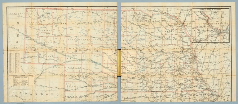
Post Route Map of the States of Kansas and Nebraska.
List No
15913.002
Note
Date estimated.
Author
United States. Post Office Department
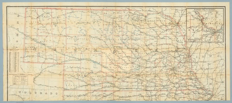
Full Title
(Post Route Map of the States of Kansas and Nebraska.)
List No
15914.002
Note
Date estimated.
Author
United States. Post Office Department
Full Title
(Post Route Map of the States of Kansas and Nebraska.)
List No
15914.003
Note
Date estimated.
Author
[White, Ruth Taylor, Western Air Express]
Full Title
Los Angeles-Kansas City : 1,417 miles - 12 hours. First and fastest all daylight passenger airway. Cartograph by Ruth Taylor White. (to accompany) Western Air Express Travel by Air : Travel by Western Air Express : Speend - comfort - dependability. Cartograph by Ruth Taylor White. Printed in U.S.A. in October, 1929.
List No
11777.003
Note
Double page pictorial map. Showing Western Air express routes, flying times and distance, major cites landmarks, forest, winter and Summer sports, recreational activities, places of interest, industry, farms, rivers and mountains. Relief shown pictorially. Includes photo of a Tri-motored Fokker type aircraft, compass rose decorated with arrowhead logo and text "The Western Air Express Los Angeles-Kansa City passenger service was established in May 1929 ..."
Author
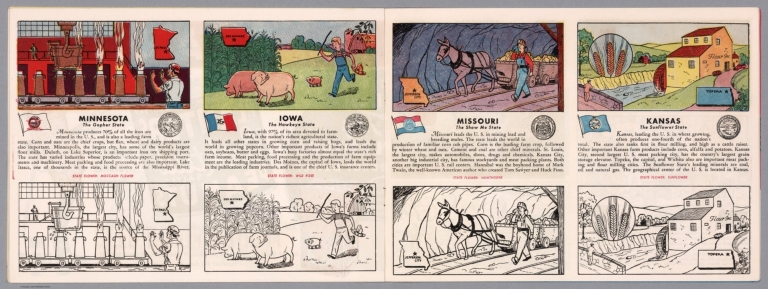
[Fisher, Joseph R., Planters Peanuts (Firm)]
Full Title
Minnesota : The gopher state -- Iowa : The hawkeye state -- Missouri : The show me state -- Kansas : The sunflower state.
List No
14374.011
Note
Four views, representing Minnesota, Iowa, Missouri and Kansas. Views show examples of the landscape and natural resources. Each view includes an inset map of the state, which marks the location of the capital city with a star. Accompanied by descriptive text, the state flags, seals and flowers: moccasin flower, wild rose, hawthorne and sunflower, respectively. The view of each state appears both in color (on top) and in black and white (bottom), the latter inviting coloration. Together, views are 18 x 52 cm, on two sheets 20 x 54 cm.
Author
Cram, George Franklin, 1841-1928
Full Title
Cram's railroad and township map of Kansas. Published by Geo. F. Cram, proprietor of the Western Map Depot. 262-264 Wabash Ave. Chicago Ills. 1882.
List No
14250.024
Note
Map of Kansas, showing railroads, county boundaries, cities and towns, and drainage. Political boundary lines in color. Features territories of indigenous peoples, such as the Cheyenne, Osage and Cherokee. Includes a bar scale and a scale statement: Scale 19 miles to an inch. With index numbers along the perimeter, and decorative border. 39 x 53 cm, on sheet 45 x 58.
Author
[Atchison and Nebraska Railroad, Chicago, Burlington, and Quincy Railroad]
Full Title
Composite: 24 sheets. A. & N. R.R. (Plans for route of Atchison and Nebraska Railroad)
List No
10287.025
Note
A set of 24 hand-drawn and colored maps showing the route of the proposed Atchison and Nebraska Railroad in northern Kansas and southern Nebraska, just west of the Missouri River. Many annotations in pencil list the land owners of parcels the proposed railroad line goes through and the cost per acre under sale contract. There are also notes on sheet 8 on the Condemnation of land for an owner who will not sell. The line appears to have been built approximately according to the drawings although in some areas the route was changed - this is based on comparing the routes shown on the 1887 county maps. The set of maps provides a detailed record of how land was secured for the railroads and how the lines were surveyed. View in Google Earth https://rumsey3.s3.amazonaws.com/Atchison_and_Nebraska_Railroad_1872.kmz
Author
[Atchison and Nebraska Railroad, Chicago, Burlington, and Quincy Railroad]
Full Title
Composite: County maps of Richardson county in Nebraska, and Doniphan, Brown, and Atchison counties in Kansas.
List No
10287.026
Note
A set of 24 hand-drawn and colored maps showing the route of the proposed Atchison and Nebraska Railroad in northern Kansas and southern Nebraska, just west of the Missouri River. Many annotations in pencil list the land owners of parcels the proposed railroad line goes through and the cost per acre under sale contract. There are also notes on sheet 8 on the Condemnation of land for an owner who will not sell. The line appears to have been built approximately according to the drawings although in some areas the route was changed - this is based on comparing the routes shown on the 1887 county maps. The set of maps provides a detailed record of how land was secured for the railroads and how the lines were surveyed. View in Google Earth https://rumsey3.s3.amazonaws.com/Atchison_and_Nebraska_Railroad_1872.kmz
Author
[Atchison and Nebraska Railroad, Chicago, Burlington, and Quincy Railroad]
Full Title
Composite: 24 sheets. A. & N. R.R. (Plans for route of Atchison and Nebraska Railroad)
List No
10287.027
Note
A set of 24 hand-drawn and colored maps showing the route of the proposed Atchison and Nebraska Railroad in northern Kansas and southern Nebraska, just west of the Missouri River. Many annotations in pencil list the land owners of parcels the proposed railroad line goes through and the cost per acre under sale contract. There are also notes on sheet 8 on the Condemnation of land for an owner who will not sell. The line appears to have been built approximately according to the drawings although in some areas the route was changed - this is based on comparing the routes shown on the 1887 county maps. The set of maps provides a detailed record of how land was secured for the railroads and how the lines were surveyed. View in Google Earth https://rumsey3.s3.amazonaws.com/Atchison_and_Nebraska_Railroad_1872.kmz
Author
[Atchison and Nebraska Railroad, Chicago, Burlington, and Quincy Railroad]
Full Title
1. A. & N. R.R. (Plans for route of Atchison and Nebraska Railroad)
List No
10287.001
Note
A set of 24 hand-drawn and colored maps showing the route of the proposed Atchison and Nebraska Railroad in northern Kansas and southern Nebraska, just west of the Missouri River. Many annotations in pencil list the land owners of parcels the proposed railroad line goes through and the cost per acre under sale contract. There are also notes on sheet 8 on the Condemnation of land for an owner who will not sell. The line appears to have been built approximately according to the drawings although in some areas the route was changed - this is based on comparing the routes shown on the 1887 county maps. The set of maps provides a detailed record of how land was secured for the railroads and how the lines were surveyed. View in Google Earth https://rumsey3.s3.amazonaws.com/Atchison_and_Nebraska_Railroad_1872.kmz
Author
[Atchison and Nebraska Railroad, Chicago, Burlington, and Quincy Railroad]
Full Title
2. A. & N. R.R. (Plans for route of Atchison and Nebraska Railroad)
List No
10287.002
Note
A set of 24 hand-drawn and colored maps showing the route of the proposed Atchison and Nebraska Railroad in northern Kansas and southern Nebraska, just west of the Missouri River. Many annotations in pencil list the land owners of parcels the proposed railroad line goes through and the cost per acre under sale contract. There are also notes on sheet 8 on the Condemnation of land for an owner who will not sell. The line appears to have been built approximately according to the drawings although in some areas the route was changed - this is based on comparing the routes shown on the 1887 county maps. The set of maps provides a detailed record of how land was secured for the railroads and how the lines were surveyed. View in Google Earth https://rumsey3.s3.amazonaws.com/Atchison_and_Nebraska_Railroad_1872.kmz
Author
[Atchison and Nebraska Railroad, Chicago, Burlington, and Quincy Railroad]
Full Title
3. A. & N. R.R. (Plans for route of Atchison and Nebraska Railroad)
List No
10287.003
Note
A set of 24 hand-drawn and colored maps showing the route of the proposed Atchison and Nebraska Railroad in northern Kansas and southern Nebraska, just west of the Missouri River. Many annotations in pencil list the land owners of parcels the proposed railroad line goes through and the cost per acre under sale contract. There are also notes on sheet 8 on the Condemnation of land for an owner who will not sell. The line appears to have been built approximately according to the drawings although in some areas the route was changed - this is based on comparing the routes shown on the 1887 county maps. The set of maps provides a detailed record of how land was secured for the railroads and how the lines were surveyed. View in Google Earth https://rumsey3.s3.amazonaws.com/Atchison_and_Nebraska_Railroad_1872.kmz
Author
Cram, George Franklin
Full Title
(Covers to) New Rail Road & township map of Missouri and Kansas : Published by Geo. F. Cram & Co. Western Map Depot. 148 Lake Street, Chicago Ills.
List No
7827.001
Note
Regional Cram's pocket map, 1st. edition. With full color map, 37X79, with 3 vignettes. Folded into black cloth covers 14x9 with "New Rail-Road & Township Map Of Kansas and Missouri : Published By Geo. F. Cram & Co." in gilt. Geo. F. Cram & Co. advertisement on verso of front cover.
Author
Cram, George Franklin
Full Title
New Rail Road & township map of Missouri and Kansas : Published by Geo. F. Cram & Co. Western Map Depot. 148 Lake Street, Chicago Ills.
List No
7827.002
Note
Outline color regional map, with 3 vignettes. Folded into black cloth covers 14x9 with "New Rail-Road & Township Map Of Kansas and Missouri : Published By Geo. F. Cram & Co." in gilt. Identifies counties and clearly shows railroad lines.
Author
U.S. War Department
Full Title
(Covers to) Engineer Bureau, War Department. Map Of The States Of Kansas And Texas And Indian Territory, With Parts Of The Territories Of Colorado And New Mexico. From the most recent official surveys and explorations and other authentic information. 1867. J. Bien, Lith. 24 Vesey St. N.Y.
List No
2320A
Author
U.S. War Department
Full Title
Engineer Bureau, War Department. Map Of The States Of Kansas And Texas And Indian Territory, With Parts Of The Territories Of Colorado And New Mexico. From the most recent official surveys and explorations and other authentic information. 1867. J. Bien, Lith. 24 Vesey St. N.Y.
List No
2320.001
Note
1st edition. Not in Streeter, Phillips, Wheat. Map shows routes of important reconnaissances, Indian trails, roads, railroads in operation, projected railroads, army routes, Indian lands and reservations. One of the earliest detailed Army surveys of the area. The map was printed in two sheets, a north sheet and a south sheet. The north sheet appears in the Atlas to Accompany the Official Records of the Union and Confederate Armies as Plate CXIX, with the same title as this map, but with the title placed in the upper right corner of the north sheet. We also have the North sheet without title, dated c1875, with much additional information on new routes, railroads, etc. This map is signed by William E. Merrill, Maj. Engrs., and dated August 10, 1867. Merrill also signed our copy of the Warren Map of the U.S., 1867, with a signature date of August 26, 1867 Merrill later made maps of Kansas (See Karrow). Graff misspells Merrill's name, as does Streeter (his signature is hard to read). Dissected into 48 sections and mounted on linen. Map folds into two dark green cloth end boards 22.5x13.5 with paper label reading "Kansas, Texas, And Indian Territory, With Parts Of Colorado And New Mexico. Engineer Bureau, W.D. Prepared for Issue in Engineer Office, M.D. Mo. All Person Into Whose Hands The Map Falls Are Particularly Requested To Send All Corrections And Additions To The Chief Engineer, Mil. Div. Of The Mo., St. Louis." With hand painted color.
Author
Colton, J. H.
Full Title
(Covers to) Nebraska And Kansas. Published By J.H. Colton & Co. No. 172 William St. New York. Entered ... 1854 by J.H. Colton ... New York. (inset) Map Of The Territory acquired from Mexico by the Gadsden Treaty, 1854. (untitled inset of U.S., Mexico, Central America). Printed by D. Mc Lellan, 26 Spruce St. N.Y.
List No
3873A
Author
Colton, J. H.
Full Title
Nebraska And Kansas. Published By J.H. Colton & Co. No. 172 William St. New York. Entered ... 1854 by J.H. Colton ... New York. (inset) Map Of The Territory acquired from Mexico by the Gadsden Treaty, 1854. (untitled inset of U.S., Mexico, Central America). Printed by D. Mc Lellan, 26 Spruce St. N.Y.
List No
3873.001
Note
First edition, first state. First map to show the new Kansas and Nebraska; also shows the important Gadsden Purchase of the same year. This state precedes all other copies we have seen - it is an early pull from the late 1854, early 1855 Colton Map of the United States of America... wall map plate (see our #2834, indicating it appeared in middle or late 1854 - see our 1855 wall map copy #2278 for the corrected topography), with the title different from the second 1854 state, in that the letters of Nebraska and Kansas have stars in them and are open as opposed to the black letters of the second state. Also, this first state has numerous areas that are "cleaned up" in the second state: the trail that crosses the two forks of the Colorado in southern Utah near the map edge has the word "Route" on it - this is removed in the second state; the vine border is reversed from the first to the second state; Louisiana is written straight across in the first - it curves down in the second; Bucksport and San Augustine are shown in Texas along the map southern edge in the second state and not in the first; Sacket's Well and Laguna in California in the inset map are given dots for their location in the second state but not in the first. There are other changes. Streeter shows a second edition in 1855, Heaston a third edition in 1856, but both copyrighted 1855. These have various route changes and place names added when compared to the 1854. A fourth edition appeared in 1857 (see Karrow 12-0361.2 and Graff 836) with the inset of the U.S. changed to Eastern Nebraska and Kansas. Map is full color by state, folded into red cloth covers 15x9 with "Nebraska And Kansas" stamped in gilt, advertisement for Colton on inside front cover.
Author
Appleton, D. & Co.
Full Title
Map of Kansas. Copyright 1891 by Matthews-Northrup Co. ... Buffalo, New York. (to accompany) The Library Atlas Of Modern Geography ... New York, D. Appleton And Company 1892. (on upper margin) Kansas. 65.
List No
0026.170
Note
Color map. Shows county boundaries and county seat, capital, railways, roads, etc. "Size of type indicates importance of the places". Includes notes. Prime meridians are Greenwich and Washington.
Author
Arbuckle Bros.
Full Title
Territory of Wyoming, Alabama, Louisiana, Kansas. Copyright 1889 Arbuckle Bros. N.Y.
List No
0027.011
Note
Sheet with maps of four states in full color. Wyoming's information includes a long paragraph on Yellowstone National Park, which is noted on the card as well. It is mentioned that in Louisiana, yellow fever epidemics swept through the state in 1853, 1867 and 1878. Each card measures 7.5 x 12.5 cm.
Author
Asher & Adams
Full Title
Asher & Adams' Kansas. Entered according to Act of Congress in the year 1874 by Asher & Adams ... at Washington. (New York, 1874)
List No
0041.026
Note
Hand col. engraved map. Shows townships, distances along railroads, etc. Prime meridians: Greenwich and Washington.
Author
Asher & Adams
Full Title
Asher & Adams' Nebraska. Entered according to Act of Congress in the year 1874 by Asher & Adams ... at Washington. (New York, 1874)
List No
0041.027
Note
Hand col. engraved map. Shows townships, distances along railroads, etc. Prime meridians: Greenwich and Washington.
Author
Colton, G.W.
Full Title
Nebraska And Kanzas. Published By J.H. Colton & Co. No. 172 William St. New York. Entered ... 1855 by J.H. Colton & Co. ... New York. No. 50.
List No
0149.055
Note
In full color by state. Nebraska extends from the western banks of the Missouri to the Rocky Mountains from east to west and from the northern border of the US to the 40th parallel from north to south. Route of the proposed Pacific Railroad shown.
Author
Colton, G.W.
Full Title
Colton's Map of Kansas, Nebraska, Dakota & Indian Territory. Published By J. H. Colton. No. 172 William St. New York.
List No
0151.058
Note
Map showing the boundaries in color. Prime meridians are Greenwich and Washington D.C.
Author
Colton, G.W.
Full Title
Colton's Kansas. Published By G. W & C. B. Colton & Co. No. 172 William St. New York.
List No
0152.063
Note
Prime meridians are Washington D.C. and Greenwich.
Author
Cram, George Franklin
Full Title
Kansas.
List No
0210.044
Note
Prime meridians Greenwich and Washington.
Author
Gray, O.W.
Full Title
Gray's Atlas Map of Kansas.
List No
0310.071
Author
[Gray, Frank A., Gray, O.W.]
Full Title
Gray's New Map of Kansas by Frank A. Gray. Entered ... 1881 by O.W. Gray & Son.
List No
0312.047
Author
Johnson, A.J.
Full Title
Johnson's Missouri And Kansas By Johnson And Ward.
List No
0352.039
Note
Full color by county or region, with heavy outlines around the states. Includes three vignettes: Santa Fe from the Great Missouri Trail, Spearing Fish, and Fire on the Prairie. Shows railroads, roads, and Indian reservations. Prime meridians are Greenwich and Washington D.C. Relief shown by hachures.
Author
Johnson, A.J.
Full Title
Johnson's Missouri and Kansas. Entered ... 1865.
List No
0358.044
Author
Leahy, J.F.
Full Title
(Index to) Leahy's Hotel Guide and Railway Distance Maps. Kansas.
List No
0425.042
Note
Alphabetical index list of the Hotels of the town with the number of rooms of each, their rates per day and the population of the town. Includes population of the state, Explanation of abbreviation of the railroad of the state, and advertisements.
Author
Leahy, J.F.
Full Title
Leahy's Hotel Guide and Railway Distance Map of the State of Kansas. Published by American Hotel Register Company. Leahy Build., 228-234 W. Ontario St., Chicago, Ill. Copyrighted by J.F. Leahy, Jan., 1934.
List No
0425.043
Note
Map printed without color. Includes name of the railroad entering the town, and distance between towns.
Author
Leahy, J.F.
Full Title
(Index to) Leahy's Hotel Guide and Railway Distance Maps. Kansas.
List No
0425.044
Note
Alphabetical index list of the Hotels of the town with the number of rooms of each, their rates per day and the population of the town. Includes population of the state, Explanation of abbreviation of the railroad of the state, and advertisements.
Author
Leahy, J.F.
Full Title
Leahy's Hotel Guide and Railway Distance Map of the State of Kansas. Published by American Hotel Register Company. Leahy Build., 228-234 W. Ontario St., Chicago, Ill. Copyrighted by J.F. Leahy, Jan., 1934.
List No
0425.045
Note
Map printed without color. Includes name of the railroad entering the town, and distance between towns.
Author
Johnson, A.J.
Full Title
Johnson's Missouri And Kansas By Johnson And Ward.
List No
0535.037
Note
In full color by county or region. Includes three vignettes: Santa Fe from the Great Missouri Trail, Spearing Fish, and Fire on the Prairie. Relief shown by hachures. Meridians Greenwich and Washington D.C.
Author
Johnson, A.J.
Full Title
Johnson's Nebraska, Dakota, Idaho, and Montana Published By Johnson And Ward.
List No
0535.039
Note
Relief shown by hachures. Meridians Greenwich and Washington D.C.
Author
Mitchell, Samuel Augustus Jr.
Full Title
Map of Kansas, Nebraska and Colorado. Showing also the southern portion of Dacotah. Drawn & Engraved by W.H. Gamble Philada. Entered ... 1861 by S. Augustus Mitchell, Jr. ... Pennsylvania.
List No
0572.037
Note
Full color map by county. Shows settlements, Indian tribes, railroads, etc. Covers also parts of Wyoming, Iowa, Indian Territory, New Mexico and Texas. Relief shown by hachures. Prime meridians are Greenwich and Washington, D.C.
Author
Mitchell, Samuel Augustus Jr.
Full Title
Map of Kansas, Nebraska and Colorado. Showing the Southern Portion of Dacotah. Drawn and Engraved by W.H. Gamble Philada. Entered ... 1867 by S. Augustus Mitchell, Jr. ... Pennsylvania.
List No
0579.040
Note
Color map by state and county. Relief shown by hachures. Prime meridians are Greenwich and Washington, D.C.
Author
Mitchell, Samuel Augustus
Full Title
County & township map of the states of Kansas and Nebraska. Drawn and engraved by W.H. Gamble, Philadelphia. Entered ... 1879 by S. Augustus Mitchell ... Washington. (1880)
List No
0586.041
Note
Hand colored. Shows settlements, railroads, rivers, etc. Prime meridians: Greenwich and Washington.
Author
Mitchell, Samuel Augustus Jr.
Full Title
County & township map of the states of Kansas and Nebraska. Copyright by S. Augustus Mitchell 1884.
List No
0592.043
Note
Hand colored. Shows settlements, rivers, railroads, etc. Prime meridians: Greenwich and Washington.
Full Title
County & township map of the states of Kansas and Nebraska. Copyright 1887 by Wm. M. Bradley & Bro. (1890)
List No
0594.041
Note
Hand colored. Shows settlements, rivers, railroads, etc. Prime meridians: Greenwich and Washington.
Author
Gunnison, J.W.
Full Title
From the Western Boundary of Missouri to the Mouth of Trap Creek; from Explorations and Surveys made under the direction of the Hon. Jefferson Davis Secretary of War by Capt. J.W. Gunnison. Topl. Engrs. assisted by Capt. E.G. Beckwith 3d Artillery. R.H. Kern Topographer in the field. 1855. Explorations and surveys for a railroad route from the Mississippi River to the Pacific Ocean. War Department. Route near the 38th & 39th Parallels. Map No. 1. Engraved by Selmar Siebert.
List No
0693.033
Note
Map begins at the 5th principal meridian and covers the area west to Tecumseh (Kansas). Uncolored. Numerous railway lines shown.
Author
Gunnison, J.W.
Full Title
From the Mouth of Trap Creek to the Santa Fe Crossing; from Explorations and Surveys made under the direction of the Hon. Jefferson Davis Secretary of War by Capt. J.W. Gunnison. Topl. Engrs. assisted by Capt. E.G. Beckwith 3d Artillery. R.H. Kern Topographer in the field. Map made under the supervision of Capt. E.G. Beckwith 3d Artillery by F.W. Egloffstein, Topographer for the Route. 1855. Explorations and surveys for a railroad route from the Mississippi River to the Pacific Ocean. War Department. Route near the 38th & 39th Parallels. Map No. 2. Engr. by Selmar Siebert.
List No
0693.034
Note
Uncolored map stretching from Uniontown (Kansas) and along the Santa Fe trail to Ft. Atkinson on the Arkansas River.
Author
Gunnison, J.W.
Full Title
From the Santa Fe Crossing to the Coo-che-to-pa Pass; from Explorations and Surveys made under the direction of the Hon. Jefferson Davis Secretary of War by Capt. J.W. Gunnison. Topl. Engrs. assisted by Capt. E.G. Beckwith 3d Artillery. R.H. Kern Topographer in the field. Map made under the supervision of Capt. E.G. Beckwith 3d Artillery by F.W. Egloffstein, Topographer for the Route. 1855. Explorations and surveys for a railroad route from the Mississippi River to the Pacific Ocean. War Department. Route near the 38th & 39th Parallels. Map No. 3. Engr. by Selmar Siebert.
List No
0693.035
Note
Uncolored map covers the area from Elk Island in the Arkansas River (Kansas) to Sahwatch Creek (Colorado). Pueblo, Colorado and Pike's Peak are shown. Settlements can be seen running south from the Sangre de Cristo Mountains to Taos (New Mexico).
Author
[Scovel, James L., O'Brien, Emmett J]
Full Title
Streams. Stream Piracy. Kaaterskill, N.Y. (on opposite page) Alluvial Plains. Weston, Mo-Kans. Scale 1:24,000.
List No
0889.052
Note
Two maps, with text, and location map. Relief shown by contours and spot heights.
Author
[Touring club italiano, Funk & Wagnalls Company.]
Full Title
Stati Uniti, United States of America, Colorado, Kansas. (with San Francisco, Oakland, Berkeley region). Propr. Artistico-letteraria del T.C.I. Ufficio cartografico del T.C.I. (1929)
List No
1012.076
Note
Color map. Relief shown by hachures and spot heights. Includes inset map of the Grand Canyon at 1:1,000,000.
Author
[Touring club italiano, Funk & Wagnalls Company.]
Full Title
(Legend to) Stati Uniti, United States of America, Colorado, Kansas ... New Mexico, Oklahoma, Texas. Propr. Artistico-letteraria del T.C.I. Ufficio cartografico del T.C.I. (1929)
List No
1012CT
Note
Explanation to maps (2 facing sheets)
Author
[Atchison and Nebraska Railroad, Chicago, Burlington, and Quincy Railroad]
Full Title
5. A. & N. R.R. (Plans for route of Atchison and Nebraska Railroad)
List No
10287.004
Note
A set of 24 hand-drawn and colored maps showing the route of the proposed Atchison and Nebraska Railroad in northern Kansas and southern Nebraska, just west of the Missouri River. Many annotations in pencil list the land owners of parcels the proposed railroad line goes through and the cost per acre under sale contract. There are also notes on sheet 8 on the Condemnation of land for an owner who will not sell. The line appears to have been built approximately according to the drawings although in some areas the route was changed - this is based on comparing the routes shown on the 1887 county maps. The set of maps provides a detailed record of how land was secured for the railroads and how the lines were surveyed. View in Google Earth https://rumsey3.s3.amazonaws.com/Atchison_and_Nebraska_Railroad_1872.kmz
Author
[Atchison and Nebraska Railroad, Chicago, Burlington, and Quincy Railroad]
Full Title
6. A. & N. R.R. (Plans for route of Atchison and Nebraska Railroad)
List No
10287.005
Note
A set of 24 hand-drawn and colored maps showing the route of the proposed Atchison and Nebraska Railroad in northern Kansas and southern Nebraska, just west of the Missouri River. Many annotations in pencil list the land owners of parcels the proposed railroad line goes through and the cost per acre under sale contract. There are also notes on sheet 8 on the Condemnation of land for an owner who will not sell. The line appears to have been built approximately according to the drawings although in some areas the route was changed - this is based on comparing the routes shown on the 1887 county maps. The set of maps provides a detailed record of how land was secured for the railroads and how the lines were surveyed. View in Google Earth https://rumsey3.s3.amazonaws.com/Atchison_and_Nebraska_Railroad_1872.kmz
Author
[Atchison and Nebraska Railroad, Chicago, Burlington, and Quincy Railroad]
Full Title
7. A. & N. R.R. (Plans for route of Atchison and Nebraska Railroad)
List No
10287.006
Note
A set of 24 hand-drawn and colored maps showing the route of the proposed Atchison and Nebraska Railroad in northern Kansas and southern Nebraska, just west of the Missouri River. Many annotations in pencil list the land owners of parcels the proposed railroad line goes through and the cost per acre under sale contract. There are also notes on sheet 8 on the Condemnation of land for an owner who will not sell. The line appears to have been built approximately according to the drawings although in some areas the route was changed - this is based on comparing the routes shown on the 1887 county maps. The set of maps provides a detailed record of how land was secured for the railroads and how the lines were surveyed. View in Google Earth https://rumsey3.s3.amazonaws.com/Atchison_and_Nebraska_Railroad_1872.kmz
Author
[Atchison and Nebraska Railroad, Chicago, Burlington, and Quincy Railroad]
Full Title
8. A. & N. R.R. (Plans for route of Atchison and Nebraska Railroad)
List No
10287.007
Note
A set of 24 hand-drawn and colored maps showing the route of the proposed Atchison and Nebraska Railroad in northern Kansas and southern Nebraska, just west of the Missouri River. Many annotations in pencil list the land owners of parcels the proposed railroad line goes through and the cost per acre under sale contract. There are also notes on sheet 8 on the Condemnation of land for an owner who will not sell. The line appears to have been built approximately according to the drawings although in some areas the route was changed - this is based on comparing the routes shown on the 1887 county maps. The set of maps provides a detailed record of how land was secured for the railroads and how the lines were surveyed. View in Google Earth https://rumsey3.s3.amazonaws.com/Atchison_and_Nebraska_Railroad_1872.kmz
Author
[Atchison and Nebraska Railroad, Chicago, Burlington, and Quincy Railroad]
Full Title
9. A. & N. R.R. (Plans for route of Atchison and Nebraska Railroad)
List No
10287.008
Note
A set of 24 hand-drawn and colored maps showing the route of the proposed Atchison and Nebraska Railroad in northern Kansas and southern Nebraska, just west of the Missouri River. Many annotations in pencil list the land owners of parcels the proposed railroad line goes through and the cost per acre under sale contract. There are also notes on sheet 8 on the Condemnation of land for an owner who will not sell. The line appears to have been built approximately according to the drawings although in some areas the route was changed - this is based on comparing the routes shown on the 1887 county maps. The set of maps provides a detailed record of how land was secured for the railroads and how the lines were surveyed. View in Google Earth https://rumsey3.s3.amazonaws.com/Atchison_and_Nebraska_Railroad_1872.kmz
Author
[Atchison and Nebraska Railroad, Chicago, Burlington, and Quincy Railroad]
Full Title
10. A. & N. R.R. (Plans for route of Atchison and Nebraska Railroad)
List No
10287.009
Note
A set of 24 hand-drawn and colored maps showing the route of the proposed Atchison and Nebraska Railroad in northern Kansas and southern Nebraska, just west of the Missouri River. Many annotations in pencil list the land owners of parcels the proposed railroad line goes through and the cost per acre under sale contract. There are also notes on sheet 8 on the Condemnation of land for an owner who will not sell. The line appears to have been built approximately according to the drawings although in some areas the route was changed - this is based on comparing the routes shown on the 1887 county maps. The set of maps provides a detailed record of how land was secured for the railroads and how the lines were surveyed. View in Google Earth https://rumsey3.s3.amazonaws.com/Atchison_and_Nebraska_Railroad_1872.kmz
Author
[Atchison and Nebraska Railroad, Chicago, Burlington, and Quincy Railroad]
Full Title
11. A. & N. R.R. (Plans for route of Atchison and Nebraska Railroad)
List No
10287.010
Note
A set of 24 hand-drawn and colored maps showing the route of the proposed Atchison and Nebraska Railroad in northern Kansas and southern Nebraska, just west of the Missouri River. Many annotations in pencil list the land owners of parcels the proposed railroad line goes through and the cost per acre under sale contract. There are also notes on sheet 8 on the Condemnation of land for an owner who will not sell. The line appears to have been built approximately according to the drawings although in some areas the route was changed - this is based on comparing the routes shown on the 1887 county maps. The set of maps provides a detailed record of how land was secured for the railroads and how the lines were surveyed. View in Google Earth https://rumsey3.s3.amazonaws.com/Atchison_and_Nebraska_Railroad_1872.kmz
Author
[Atchison and Nebraska Railroad, Chicago, Burlington, and Quincy Railroad]
Full Title
12. A. & N. R.R. (Plans for route of Atchison and Nebraska Railroad)
List No
10287.011
Note
A set of 24 hand-drawn and colored maps showing the route of the proposed Atchison and Nebraska Railroad in northern Kansas and southern Nebraska, just west of the Missouri River. Many annotations in pencil list the land owners of parcels the proposed railroad line goes through and the cost per acre under sale contract. There are also notes on sheet 8 on the Condemnation of land for an owner who will not sell. The line appears to have been built approximately according to the drawings although in some areas the route was changed - this is based on comparing the routes shown on the 1887 county maps. The set of maps provides a detailed record of how land was secured for the railroads and how the lines were surveyed. View in Google Earth https://rumsey3.s3.amazonaws.com/Atchison_and_Nebraska_Railroad_1872.kmz
Author
[Atchison and Nebraska Railroad, Chicago, Burlington, and Quincy Railroad]
Full Title
13. A. & N. R.R. (Plans for route of Atchison and Nebraska Railroad)
List No
10287.012
Note
A set of 24 hand-drawn and colored maps showing the route of the proposed Atchison and Nebraska Railroad in northern Kansas and southern Nebraska, just west of the Missouri River. Many annotations in pencil list the land owners of parcels the proposed railroad line goes through and the cost per acre under sale contract. There are also notes on sheet 8 on the Condemnation of land for an owner who will not sell. The line appears to have been built approximately according to the drawings although in some areas the route was changed - this is based on comparing the routes shown on the 1887 county maps. The set of maps provides a detailed record of how land was secured for the railroads and how the lines were surveyed. View in Google Earth https://rumsey3.s3.amazonaws.com/Atchison_and_Nebraska_Railroad_1872.kmz
Author
[Atchison and Nebraska Railroad, Chicago, Burlington, and Quincy Railroad]
Full Title
14. A. & N. R.R. (Plans for route of Atchison and Nebraska Railroad)
List No
10287.013
Note
A set of 24 hand-drawn and colored maps showing the route of the proposed Atchison and Nebraska Railroad in northern Kansas and southern Nebraska, just west of the Missouri River. Many annotations in pencil list the land owners of parcels the proposed railroad line goes through and the cost per acre under sale contract. There are also notes on sheet 8 on the Condemnation of land for an owner who will not sell. The line appears to have been built approximately according to the drawings although in some areas the route was changed - this is based on comparing the routes shown on the 1887 county maps. The set of maps provides a detailed record of how land was secured for the railroads and how the lines were surveyed. View in Google Earth https://rumsey3.s3.amazonaws.com/Atchison_and_Nebraska_Railroad_1872.kmz
Author
[Atchison and Nebraska Railroad, Chicago, Burlington, and Quincy Railroad]
Full Title
15. A. & N. R.R. (Plans for route of Atchison and Nebraska Railroad)
List No
10287.014
Note
A set of 24 hand-drawn and colored maps showing the route of the proposed Atchison and Nebraska Railroad in northern Kansas and southern Nebraska, just west of the Missouri River. Many annotations in pencil list the land owners of parcels the proposed railroad line goes through and the cost per acre under sale contract. There are also notes on sheet 8 on the Condemnation of land for an owner who will not sell. The line appears to have been built approximately according to the drawings although in some areas the route was changed - this is based on comparing the routes shown on the 1887 county maps. The set of maps provides a detailed record of how land was secured for the railroads and how the lines were surveyed. View in Google Earth https://rumsey3.s3.amazonaws.com/Atchison_and_Nebraska_Railroad_1872.kmz
Author
[Atchison and Nebraska Railroad, Chicago, Burlington, and Quincy Railroad]
Full Title
16. A. & N. R.R. (Plans for route of Atchison and Nebraska Railroad)
List No
10287.015
Note
A set of 24 hand-drawn and colored maps showing the route of the proposed Atchison and Nebraska Railroad in northern Kansas and southern Nebraska, just west of the Missouri River. Many annotations in pencil list the land owners of parcels the proposed railroad line goes through and the cost per acre under sale contract. There are also notes on sheet 8 on the Condemnation of land for an owner who will not sell. The line appears to have been built approximately according to the drawings although in some areas the route was changed - this is based on comparing the routes shown on the 1887 county maps. The set of maps provides a detailed record of how land was secured for the railroads and how the lines were surveyed. View in Google Earth https://rumsey3.s3.amazonaws.com/Atchison_and_Nebraska_Railroad_1872.kmz
Author
[Atchison and Nebraska Railroad, Chicago, Burlington, and Quincy Railroad]
Full Title
17. A. & N. R.R. (Plans for route of Atchison and Nebraska Railroad)
List No
10287.016
Note
A set of 24 hand-drawn and colored maps showing the route of the proposed Atchison and Nebraska Railroad in northern Kansas and southern Nebraska, just west of the Missouri River. Many annotations in pencil list the land owners of parcels the proposed railroad line goes through and the cost per acre under sale contract. There are also notes on sheet 8 on the Condemnation of land for an owner who will not sell. The line appears to have been built approximately according to the drawings although in some areas the route was changed - this is based on comparing the routes shown on the 1887 county maps. The set of maps provides a detailed record of how land was secured for the railroads and how the lines were surveyed. View in Google Earth https://rumsey3.s3.amazonaws.com/Atchison_and_Nebraska_Railroad_1872.kmz
Author
[Atchison and Nebraska Railroad, Chicago, Burlington, and Quincy Railroad]
Full Title
18. A. & N. R.R. (Plans for route of Atchison and Nebraska Railroad)
List No
10287.017
Note
A set of 24 hand-drawn and colored maps showing the route of the proposed Atchison and Nebraska Railroad in northern Kansas and southern Nebraska, just west of the Missouri River. Many annotations in pencil list the land owners of parcels the proposed railroad line goes through and the cost per acre under sale contract. There are also notes on sheet 8 on the Condemnation of land for an owner who will not sell. The line appears to have been built approximately according to the drawings although in some areas the route was changed - this is based on comparing the routes shown on the 1887 county maps. The set of maps provides a detailed record of how land was secured for the railroads and how the lines were surveyed. View in Google Earth https://rumsey3.s3.amazonaws.com/Atchison_and_Nebraska_Railroad_1872.kmz
Author
[Atchison and Nebraska Railroad, Chicago, Burlington, and Quincy Railroad]
Full Title
19. A. & N. R.R. (Plans for route of Atchison and Nebraska Railroad)
List No
10287.018
Note
A set of 24 hand-drawn and colored maps showing the route of the proposed Atchison and Nebraska Railroad in northern Kansas and southern Nebraska, just west of the Missouri River. Many annotations in pencil list the land owners of parcels the proposed railroad line goes through and the cost per acre under sale contract. There are also notes on sheet 8 on the Condemnation of land for an owner who will not sell. The line appears to have been built approximately according to the drawings although in some areas the route was changed - this is based on comparing the routes shown on the 1887 county maps. The set of maps provides a detailed record of how land was secured for the railroads and how the lines were surveyed. View in Google Earth https://rumsey3.s3.amazonaws.com/Atchison_and_Nebraska_Railroad_1872.kmz
Author
[Atchison and Nebraska Railroad, Chicago, Burlington, and Quincy Railroad]
Full Title
20. A. & N. R.R. (Plans for route of Atchison and Nebraska Railroad)
List No
10287.019
Note
A set of 24 hand-drawn and colored maps showing the route of the proposed Atchison and Nebraska Railroad in northern Kansas and southern Nebraska, just west of the Missouri River. Many annotations in pencil list the land owners of parcels the proposed railroad line goes through and the cost per acre under sale contract. There are also notes on sheet 8 on the Condemnation of land for an owner who will not sell. The line appears to have been built approximately according to the drawings although in some areas the route was changed - this is based on comparing the routes shown on the 1887 county maps. The set of maps provides a detailed record of how land was secured for the railroads and how the lines were surveyed. View in Google Earth https://rumsey3.s3.amazonaws.com/Atchison_and_Nebraska_Railroad_1872.kmz
Author
[Atchison and Nebraska Railroad, Chicago, Burlington, and Quincy Railroad]
Full Title
21. A. & N. R.R. (Plans for route of Atchison and Nebraska Railroad)
List No
10287.020
Note
A set of 24 hand-drawn and colored maps showing the route of the proposed Atchison and Nebraska Railroad in northern Kansas and southern Nebraska, just west of the Missouri River. Many annotations in pencil list the land owners of parcels the proposed railroad line goes through and the cost per acre under sale contract. There are also notes on sheet 8 on the Condemnation of land for an owner who will not sell. The line appears to have been built approximately according to the drawings although in some areas the route was changed - this is based on comparing the routes shown on the 1887 county maps. The set of maps provides a detailed record of how land was secured for the railroads and how the lines were surveyed. View in Google Earth https://rumsey3.s3.amazonaws.com/Atchison_and_Nebraska_Railroad_1872.kmz
Author
[Atchison and Nebraska Railroad, Chicago, Burlington, and Quincy Railroad]
Full Title
21a. A. & N. R.R. (Plans for route of Atchison and Nebraska Railroad)
List No
10287.021
Note
A set of 24 hand-drawn and colored maps showing the route of the proposed Atchison and Nebraska Railroad in northern Kansas and southern Nebraska, just west of the Missouri River. Many annotations in pencil list the land owners of parcels the proposed railroad line goes through and the cost per acre under sale contract. There are also notes on sheet 8 on the Condemnation of land for an owner who will not sell. The line appears to have been built approximately according to the drawings although in some areas the route was changed - this is based on comparing the routes shown on the 1887 county maps. The set of maps provides a detailed record of how land was secured for the railroads and how the lines were surveyed. View in Google Earth https://rumsey3.s3.amazonaws.com/Atchison_and_Nebraska_Railroad_1872.kmz
Author
[Atchison and Nebraska Railroad, Chicago, Burlington, and Quincy Railroad]
Full Title
27. A. & N. R.R. (Plans for route of Atchison and Nebraska Railroad)
List No
10287.022
Note
A set of 24 hand-drawn and colored maps showing the route of the proposed Atchison and Nebraska Railroad in northern Kansas and southern Nebraska, just west of the Missouri River. Many annotations in pencil list the land owners of parcels the proposed railroad line goes through and the cost per acre under sale contract. There are also notes on sheet 8 on the Condemnation of land for an owner who will not sell. The line appears to have been built approximately according to the drawings although in some areas the route was changed - this is based on comparing the routes shown on the 1887 county maps. The set of maps provides a detailed record of how land was secured for the railroads and how the lines were surveyed. View in Google Earth https://rumsey3.s3.amazonaws.com/Atchison_and_Nebraska_Railroad_1872.kmz
Author
[Atchison and Nebraska Railroad, Chicago, Burlington, and Quincy Railroad]
Full Title
28. A. & N. R.R. (Plans for route of Atchison and Nebraska Railroad)
List No
10287.023
Note
A set of 24 hand-drawn and colored maps showing the route of the proposed Atchison and Nebraska Railroad in northern Kansas and southern Nebraska, just west of the Missouri River. Many annotations in pencil list the land owners of parcels the proposed railroad line goes through and the cost per acre under sale contract. There are also notes on sheet 8 on the Condemnation of land for an owner who will not sell. The line appears to have been built approximately according to the drawings although in some areas the route was changed - this is based on comparing the routes shown on the 1887 county maps. The set of maps provides a detailed record of how land was secured for the railroads and how the lines were surveyed. View in Google Earth https://rumsey3.s3.amazonaws.com/Atchison_and_Nebraska_Railroad_1872.kmz
Author
[Atchison and Nebraska Railroad, Chicago, Burlington, and Quincy Railroad]
Full Title
29. A. & N. R.R. (Plans for route of Atchison and Nebraska Railroad)
List No
10287.024
Note
A set of 24 hand-drawn and colored maps showing the route of the proposed Atchison and Nebraska Railroad in northern Kansas and southern Nebraska, just west of the Missouri River. Many annotations in pencil list the land owners of parcels the proposed railroad line goes through and the cost per acre under sale contract. There are also notes on sheet 8 on the Condemnation of land for an owner who will not sell. The line appears to have been built approximately according to the drawings although in some areas the route was changed - this is based on comparing the routes shown on the 1887 county maps. The set of maps provides a detailed record of how land was secured for the railroads and how the lines were surveyed. View in Google Earth https://rumsey3.s3.amazonaws.com/Atchison_and_Nebraska_Railroad_1872.kmz
Author
U.S. General Land Office
Full Title
(12) Map Showing the progress of the Public surveys in Kansas and Nebraska. 1866. Surveyor General's Office, Leavenworth, Kansas, August 25th, 1866. Department of the Interior, General Land Office, October 2nd 1866. Jo. S. Wilson, Commissioner. No. 15. Bowen & Co. lith. Philada.
List No
1070.015
Note
In outline color with the land offices in pink and the surveyor general's office in green. The legend includes coal, lead, platina, marble, and salt lands.
Author
U.S. General Land Office
Full Title
(Map 11 - Wyoming, Nebraska, Colorado, Kansas, South Dakota).
List No
1071.013
Note
One of the series of adjacent sixteen maps. Mounted on linen. Relief shown in hachures.
Author
U.S. General Land Office
Full Title
Department of the Interior, General Land Office. S.S. Burdett, Commissioner. State of Kansas. 1876. Compiled from the official records of the General Land Office and other sources by C. Roeser, Principal Draughtsman G.L.O. Photolith. & Print by Julius Bien 16 & 18 Park Place, N.Y.
List No
11179.005
Note
Color map. Includes references. Relief shown by hachures. Prime meridian is Greenwich.
Author
George Franklin Cram Company
Full Title
Railroad and county map of Kansas. Geo. F. Cram. Engraver and publisher, Chicago. (Cover title) 1885 Cram's township and rail road map of Kansas.
List No
11374.003
Note
Color map 40x56, on sheets 48x61, folded in cover 15x10, with 9 pages of text and index. Shows county boundaries, major cities, rivers, railroads and state capital. Relief shown by hachures. Includes explanation.
Author
Larrance, Isaac, 1804-1896
Full Title
Counties in Kansas. (to accompany) Larrance's Post office chart, and maps of ten states ... By Isaac Larrance. Cincinnati : Printed and for sale by I. A. Pittman. 1866.
List No
11666.026
Note
Map of Counties in Kansas, printed in red with decorative blue borders. Shows county boundaries and major roads.
Author
Larrance, Isaac, 1804-1896
Full Title
(Index Page to) County Seats in Kansas. (to accompany) Larrance's Post office chart, and maps of ten states ... By Isaac Larrance. Cincinnati : Printed and for sale by I. A. Pittman. 1866.
List No
11666.027
Note
Index to County Seats in Kansas.
Author
Larrance, Isaac, 1804-1896
Full Title
County Seats in Kansas. (to accompany) Larrance's Post office chart, and maps of ten states ... By Isaac Larrance. Cincinnati : Printed and for sale by I. A. Pittman. 1866.
List No
11666.028
Note
Map of County Seats in Kansas, printed in red with decorative blue borders. Shows county boundaries and major roads.
Author
[George F. Cram Company collection 1845-1955, National Highways Association]
Full Title
Kansas. The George F. Cram Company, Chicago. (to accompany) Auto trails and commercial survey of the United States.
List No
13688.035
Note
State of Kansas, with inset map of Leavenworth. Showing Names Highways and connecting roads in red. Includes list of Named Highways.
Author
[George F. Cram Company collection 1845-1955, National Highways Association]
Full Title
Kansas. The George F. Cram Company, Chicago. (to accompany) Auto trails and commercial survey of the United States.
List No
13688.036
Note
State of Kansas, with inset map of Leavenworth. Showing electric lines in red and administrative boundaries.
Author
Rand McNalley & Company
Full Title
Rand McNally road map : Kansas.
List No
14003.024
Note
Road map of Kansas, showing interstate and state highways, paved and dirt roads, as well as drainage and ports, and state and national parks. Includes compass rose, time zones, and bar scale with scale statement: One inch equals approximately 19.5 miles. Features legend indicating population. Copyright by Rand McNally & Company, Chicago, Ill. Lithographed in the U.S.A.
Author
[Bates, Ernest Sutherland, 1879-1939, Schiff, Herman S., Reeves, Norman, Smith, Robert E.]
Full Title
Kansas, 1861.
List No
14244.077
Note
Pictorial map of Kansas, showing political boundaries with bordering states and major rivers. Features natural resources and manufactured items (including wheat, cheese, oil and private planes). Includes a compass rose and a scroll listing notable places and events - such as Pioneer Days, Leavenworth - which are pictured in vignettes below map, in order of listing. Map is 17 x 29 cm, on sheet 23 x 29 cm. Accompanied by historical text on facing page.
Author
Cram, George Franklin, 1841-1928
Full Title
Kansas. 1899, by Geo. F. Cram.
List No
14372.107
Note
Map of Kansas. Shows political boundaries, counties, towns, railroads, topography, bodies of water, drainage, coastlines and islands. Relief shown with hachures. Includes key with explanation, latitudinal and longitudinal lines, as well as a bar scale given in miles. With alphanumeric grid corresponding to "Index of Kansas" on pages 192-197 and 200. Colored lithograph. Map is 39 x 55 cm, on double sheet 45 x 67 cm. "Index of maps" and "Index of cities" in margins, providing navigation for atlas as a whole.
Author
Mid-West Map Company
Full Title
Highway map & guide of Kansas. Mid-West Map Company, Aurora, Mo.
List No
14417.002
Note
Pocket road map for the state of Kansas. Shows state boundaries, cities, highways, roads, airports, topography, bodies of water and drainage. Relief shown with hachures. Includes explanatory text, a legend and bar scale given in miles. Indexed, with key on verso. Advertisements in margins. Printed in blue. Map is 40 x 53 cm, on sheet 44 x 56 cm.
Author
Colton, G.W.
Full Title
Colton's Kansas. Published By G. W & C. B. Colton & Co., No. 182 William St. New York.
List No
1550.058
Note
Prime meridians are Washington D.C. and Greenwich.
Author
USSR (Union of Soviet Socialist Republics).
Full Title
206-207. United States of America, South Central. The World Atlas.
List No
1603.218
Author
[Colton, G.W., Fisher, Richard Swainson]
Full Title
Nebraska and Kansas. Minnesota. (inset) vicinity, of the Falls of St. Anthony.
List No
1690.120
Author
[Cram, George, Wood Brothers]
Full Title
Kansas. (to accompany) The Columbian World's Fair atlas ... Published for: Wood Brothers Cash Store ... Unadilla, New York.
List No
1773.065
Note
Outline hand color map. Shows state and county boundaries, cities and towns. Prime meridians are Greenwich and Washington.
Author
United States. War Department
Full Title
Campaign against Sterling Price, 1864, Maj. Gen. S.R. Curtis, commanding. Executed under the direction of Lieut. G.T. Robinson, Chief Engineer, by Jacob Miller ... Westport and Big Blue, Mo. Westport and Big Blue, Oct. 22 and 23, 1864, by L.G. Bennett, Topogr. Engineer. Battle-ground of Westport, Oct. 23, 1864 by L.G. Bennett. Battle-ground of Charlot, Oct. 25, 1864. Battle-ground of Newtonia, Mo., October 28, 1864. (Harrison's Landing, Va., July 4, 1862) Osage or Mine Creek, Kans. Map of battle-field of Five Forks, Va., April 1st 1865 and of field of operation preliminary to it, showing the operations of the Fifth Army Corps, commanded by Maj. Gen. G.K. Warren. A sketch of the military prison on Johnson's Island, Ohio. Map of the battle-field of Five Forks, Va., April 1st, 1865 showing the positions of movements of the Fifth Army Corps, commanded by ... G.K. Warren. ... Julius Bien & Co., Lith., N.Y. (1891-1895)
List No
1780.066
Note
Eleven col. maps. Relief shown by hachures. Accompany documents of S.R. Curtis, William Gamble and S.P. Heintzelman.
Author
United States. War Department
Full Title
Engineer Bureau, War Department. Section of map of the states of Kansas and Texas and Indian Territory, with parts of the territories of Colorado and New Mexico. From the most recent official surveys and explorations and other authentic information. 1867. Julius Bien & Co., Lith., N.Y. (1891-1895)
List No
1780.119
Note
Col. map. Relief shown by hachures. Shows settlements, Indian reservations, roads, railroads, forts, etc. Includes table of locations with coordinates and list of authorities.
Author
[Julius Bien & Co., United States. War Department]
Full Title
General topographical map. Sheet XXV. Julius Bien & Co., Lith., N.Y. (1891-1895)
List No
1780.163
Note
Col. map. Relief shown by hachures. Shows settlements, railroads, roads, Indian reservations, etc.
Author
[Julius Bien & Co., United States. War Department]
Full Title
General topographical map. Sheet XXVI. Julius Bien & Co., Lith., N.Y. (1891-1895)
List No
1780.164
Note
Col. map. Relief shown by hachures. Shows settlements, railroads, roads, ferries, Indian reservations, etc.
Author
Hammond, C.S.
Full Title
Kansas. 5366.
List No
1954.092
Author
Bradstreet Company
Full Title
Kansas. (to accompany) Bradstreet's Pocket Atlas Of The United States. Published Exclusively for Macullar, Parker & Company, Boston, Massachusetts ... New York: The Bradstreet Company, 1885. (on verso) Entered ... 1879, by The Bradstreet Company ... Washington.
List No
2054.048
Note
Full color map. Prime meridian is Washington, D.C.
Author
Rand McNally and Company
Full Title
(Text Page) Louisiana. Kansas.
List No
2094CT
Note
List of geographical features indexed to map.
Author
Rand McNally and Company
Full Title
(Text Page) Kansas.
List No
2094CU
Note
List of geographical features indexed to map.
Author
Rand McNally and Company
Full Title
Rand, McNally & Co.'s Kansas.
List No
2094.046
Note
Counties outlined in color. Meridians Washington and Greenwich. Railroads highlighted. Relief shown by hachures.
Author
Rand McNally and Company
Full Title
(Text Page) Kansas. Nebraska.
List No
2094CV
Note
List of geographical features indexed to map.
Full Title
Kansas. (Published by George F. Cram, Chicago, Ill. 1909)
List No
2134.085
Note
Map in full color. Shows counties, settlements, railroads, etc.
Author
[Delavault, A., Vandermaelen, Philippe, 1795-1869]
Full Title
Parties des Etats-Unis et du Nouveau Mexique. Amer. Sep. no. 48. Dressee et dessinee par Ph. Vandermaelen. La lettre par Ph. Lippens. Desee. sur pierre et Lithie. par H. Ode, Avril 1825. (Quatrieme partie. - Amer. sept. Bruxelles. 1827)
List No
2212.253
Note
Hand col. lithographed map. Relief shown by hachures. Shows Indian tribes with populations. Covers parts of Colorado, Kansas, Nebraska, Texas, New Mexico and Oklahoma.
Author
[Jones, C.H., Hamilton, T.H., Williams, J.David]
Full Title
Map of Illinois, Missouri, Kansas, Arkansas, and Indian Territory.
List No
2307.020
Note
Relief shown in hachures.
Author
Cram, George Franklin
Full Title
(Covers to) Cram's Rail Road & Township Map Of Kansas. Published By Geo. F. Cram. Proprietor Of The Western Map Depot. 66 Lake St. Chicago Ills.
List No
2370.001
Note
From Cram's 1875/1878 railroad atlas. Full hand color. 16 page catalogue and Index. Folded into dark brown cloth covers 14x9 with "Indexed Railroad And Township Map Of Kansas Published By Geo. F. Cram." in gilt.
Author
Cram, George Franklin
Full Title
Cram's Rail Road & Township Map Of Kansas. Published By Geo. F. Cram. Proprietor Of The Western Map Depot. 66 Lake St. Chicago Ills.
List No
2370.002
Note
From Cram's 1875/1878 railroad atlas. Full hand color. 16 page catalogue and Index. Folded into dark brown cloth covers 14x9 with "Indexed Railroad And Township Map Of Kansas Published By Geo. F. Cram." in gilt.
Author
Wiggin, C.P.
Full Title
(Covers to) MacLean & Lawrences Sectional Map Of Kansas Territory Compiled From The U.S. Surveys By C.P. Wiggin. I hereby Certify that the above Map was compiled from the field notes of the Surveys on file in this Office. L.A MacLean, Chief Clerk. Surveyor General Office Lecompton, K.T. April 1857. Wm. Schuchman & Bro. lith. Pittsburgh.
List No
2378.001
Author
Wiggin, C.P.
Full Title
MacLean & Lawrences Sectional Map Of Kansas Territory Compiled From The U.S. Surveys By C.P. Wiggin. I hereby Certify that the above Map was compiled from the field notes of the Surveys on file in this Office. L.A MacLean, Chief Clerk. Surveyor General Office Lecompton, K.T. April 1857. Wm. Schuchman & Bro. lith. Pittsburgh.
List No
2378.002
Note
Important map showing important routes in detail. Large scale, very fine coloring. Graff 4652; Phillips Maps p346. Folded into stamped brown cloth covers 17x11.5 with "MacLean & Lawrence's Sectional Map Of Kansas Territory" in gilt.
Author
Colton, G.W.
Full Title
Colton's Kansas and Nebraska.
List No
2441.110
Author
Colton, G. W. & C. B.
Full Title
(Covers to) Colton's New Sectional Map of the State of Kansas Compiled From The United States Surveys & Other Authentic Sources. Published by G.W. & C.B. Colton. & Co. New York, 1870. Entered ... 1867 by G.W. & C.B. Colton & Co. ... New York.
List No
2453.001
Note
A two sheet map, separated into east and west halves. Heaston: "One of the first Kansas maps split into two sections." One of the largest scale maps of Kansas of the period. Full color by county, with both halves folded into dark brown cloth covers 15x10 with "Sectional Map Of The State Of Kansas Published By G.W. & C.B. Colton & Co. New York." in gilt.
Author
Colton, G. W. & C. B.
Full Title
Colton's New Sectional Map of the State of Kansas Compiled From The United States Surveys & Other Authentic Sources. Published by G.W. & C.B. Colton. & Co. New York, 1870. Entered ... 1867 by G.W. & C.B. Colton & Co. ... New York.
List No
2453.002
Note
A two sheet map, separated into east and west halves. Heaston: "One of the first Kansas maps split into two sections." One of the largest scale maps of Kansas of the period. Full color by county, with both halves folded into dark brown cloth covers 15x10 with "Sectional Map Of The State Of Kansas Published By G.W. & C.B. Colton & Co. New York." in gilt.
Author
Colton, G. W. & C. B.
Full Title
(Composite of) Colton's New Sectional Map of the State of Kansas Compiled From The United States Surveys & Other Authentic Sources. Published by G.W. & C.B. Colton. & Co. New York, 1870. Entered ... 1867 by G.W. & C.B. Colton & Co. ... New York.
List No
2453.003
Note
A two sheet map, separated into east and west halves. Heaston: "One of the first Kansas maps split into two sections." One of the largest scale maps of Kansas of the period. Full color by county, with both halves folded into dark brown cloth covers 15x10 with "Sectional Map Of The State Of Kansas Published By G.W. & C.B. Colton & Co. New York." in gilt.
Author
U.S. War Department
Full Title
Map of the States of Kansas and Texas and Indian Territory with Parts of the Territories of Colorado and New Mexico (North half sheet only).
List No
2464.000
Note
See 1st edition 1867. Untitled and undated. Updates the first edition (north half only) with more routes, battles, etc. Unfolded separate issue. No title on the map. Probably issued with the south half which had the title and is now separated. Map is without color. Shows roads, railroads, rivers, and Indian lands and reservations. Relief shown by hachures.
Author
Mitchell, Samuel Augustus
Full Title
Map of Kansas, Nebraska and Colorado. Showing also the southern portion of Dacotah. Drawn and engraved by W.H. Gamble, Philada. Entered ... 1870 by S. Augustus Mitchell, Jr. ... Pennsylvania.
List No
2483.036
Note
Hand colored. Relief shown by hachures. Shows counties, settlements, Indian tribes, railroads, etc. Covers also parts of Wyoming, Iowa, Indian Territory, New Mexico and Texas. Prime meridians: Greenwich and Washington.
Author
Mitchell, Samuel Augustus
Full Title
A New Map of Nebraska, Kansas, New Mexico and Indian Territories. Published by Charles Desilver, Philadelphia. Entered ... 1856 by Charles Desilver ... Pennsylvania.
List No
2514.040
Note
Full color map by state and region. Shows capitals, cities and towns, military and trading posts and routes of Pacific railroads. Relief shown by hachures.
Author
Mitchell, Samuel Augustus Jr., 1792-1868
Full Title
Kansas, Colorado, New Mexico & Indian Territory. (to accompany) Mitchell's New Reference Atlas for the Use of Colleges, Libraries, Families and Counting Houses. Philadelphia: Published By E.H. Butler & Co. 1865.
List No
2516.018
Note
Hand colored map. Relief shown by hachures. Showing administrative divisions, major cities, Indian reservations,rivers, lakes, and mountains. Prime meridians are Greenwich and Washington.
Author
[Lloyd, H.H., Warner & Beers]
Full Title
Atlas of the United States, Map of Utah, Arizona, New Mexico, Kansas, Colorado, and Indian Territory. Warner & Beers, Publishers. From H.H. Lloyd & Co.'s Atlas of the United States.
List No
2585.076
Note
Relief shown in hachures.
Author
Rand McNally and Company
Full Title
Kansas.
List No
2790.220
Author
Rand McNally and Company
Full Title
Relief Map of Kansas.
List No
2790.222
Author
Cram, George Franklin
Full Title
Kansas.
List No
2809.028
Note
Locations of banking towns shown by red circles. Railroads are indicated by numbers and colors and patterns, and each railroad has the same number and color and pattern in every state through which it passes. All railroads on each map are in a list keyed to the map. Border of map has a table of contents for the atlas. Relief shown by hachures. Prime meridians Washington D.C. and Greenwich.
Author
[Everts & Co., L.H. Everts & Co.]
Full Title
(Covers to) The official state atlas of Kansas compiled from government surveys, county records and personal investigations. Philadelphia. L.H. Everts & Co. 1887.
List No
2818A
Note
Huge atlas, many maps and views, scarce. With 340 numbered pages (plus many unnumbered pages) of maps and views this must be the largest State Atlas published (Andreas' Iowa has 250 pages of maps and views). The views show the remarkable development of the state over two decades after the Civil War. Many large folding maps of cities are included. Bound in new burgandy cloth covered boards with "The Official Atlas Of Kansas 1887" stamped in gilt. Maps hand painted in full color.
Author
[Everts & Co., Haskell & Wood, L.H. Everts & Co.]
Full Title
(Title Page to) The official state atlas of Kansas compiled from government surveys, county records and personal investigations. Philadelphia. L.H. Everts & Co. 1887. (on verso:) Copyright, 1887, L.H. Everts & Co. (with view:) State Capitol, Topeka, Kan. Haskell & Wood, Arch's. F.F. Goist Sc.
List No
2818B
Note
Huge atlas, many maps and views, scarce. With 340 numbered pages (plus many unnumbered pages) of maps and views this must be the largest State Atlas published (Andreas' Iowa has 250 pages of maps and views). The views show the remarkable development of the state over two decades after the Civil War. Many large folding maps of cities are included. Bound in new burgandy cloth covered boards with "The Official Atlas Of Kansas 1887" stamped in gilt. Maps hand painted in full color.
Author
[Everts & Co., L.H. Everts & Co.]
Full Title
(Contents to) The official state atlas of Kansas compiled from government surveys, county records and personal investigations. Philadelphia. L.H. Everts & Co. 1887.
List No
2818C
Note
Huge atlas, many maps and views, scarce. With 340 numbered pages (plus many unnumbered pages) of maps and views this must be the largest State Atlas published (Andreas' Iowa has 250 pages of maps and views). The views show the remarkable development of the state over two decades after the Civil War. Many large folding maps of cities are included. Bound in new burgandy cloth covered boards with "The Official Atlas Of Kansas 1887" stamped in gilt. Maps hand painted in full color.
Author
[Everts & Co., L.H. Everts & Co.]
Full Title
(Contents to) The official state atlas of Kansas compiled from government surveys, county records and personal investigations. Philadelphia. L.H. Everts & Co. 1887.
List No
2818D
Note
Huge atlas, many maps and views, scarce. With 340 numbered pages (plus many unnumbered pages) of maps and views this must be the largest State Atlas published (Andreas' Iowa has 250 pages of maps and views). The views show the remarkable development of the state over two decades after the Civil War. Many large folding maps of cities are included. Bound in new burgandy cloth covered boards with "The Official Atlas Of Kansas 1887" stamped in gilt. Maps hand painted in full color.
Author
[Everts & Co., L.H. Everts & Co.]
Full Title
(Contents to) The official state atlas of Kansas compiled from government surveys, county records and personal investigations. Philadelphia. L.H. Everts & Co. 1887.
List No
2818E
Note
Huge atlas, many maps and views, scarce. With 340 numbered pages (plus many unnumbered pages) of maps and views this must be the largest State Atlas published (Andreas' Iowa has 250 pages of maps and views). The views show the remarkable development of the state over two decades after the Civil War. Many large folding maps of cities are included. Bound in new burgandy cloth covered boards with "The Official Atlas Of Kansas 1887" stamped in gilt. Maps hand painted in full color.
Author
[Everts & Co., L.H. Everts & Co.]
Full Title
(Contents to) The official state atlas of Kansas compiled from government surveys, county records and personal investigations. Philadelphia. L.H. Everts & Co. 1887.
List No
2818F
Note
Huge atlas, many maps and views, scarce. With 340 numbered pages (plus many unnumbered pages) of maps and views this must be the largest State Atlas published (Andreas' Iowa has 250 pages of maps and views). The views show the remarkable development of the state over two decades after the Civil War. Many large folding maps of cities are included. Bound in new burgandy cloth covered boards with "The Official Atlas Of Kansas 1887" stamped in gilt. Maps hand painted in full color.
Author
[Everts & Co., L.H. Everts & Co.]
Full Title
(Contents to) The official state atlas of Kansas compiled from government surveys, county records and personal investigations. Philadelphia. L.H. Everts & Co. 1887.
List No
2818G
Note
Huge atlas, many maps and views, scarce. With 340 numbered pages (plus many unnumbered pages) of maps and views this must be the largest State Atlas published (Andreas' Iowa has 250 pages of maps and views). The views show the remarkable development of the state over two decades after the Civil War. Many large folding maps of cities are included. Bound in new burgandy cloth covered boards with "The Official Atlas Of Kansas 1887" stamped in gilt. Maps hand painted in full color.
Author
[Everts & Co., L.H. Everts & Co.]
Full Title
(Contents to) The official state atlas of Kansas compiled from government surveys, county records and personal investigations. Philadelphia. L.H. Everts & Co. 1887.
List No
2818H
Note
Huge atlas, many maps and views, scarce. With 340 numbered pages (plus many unnumbered pages) of maps and views this must be the largest State Atlas published (Andreas' Iowa has 250 pages of maps and views). The views show the remarkable development of the state over two decades after the Civil War. Many large folding maps of cities are included. Bound in new burgandy cloth covered boards with "The Official Atlas Of Kansas 1887" stamped in gilt. Maps hand painted in full color.
Author
[Everts & Co., L.H. Everts & Co.]
Full Title
(Contents to) The official state atlas of Kansas compiled from government surveys, county records and personal investigations. Philadelphia. L.H. Everts & Co. 1887.
List No
2818I
Note
Huge atlas, many maps and views, scarce. With 340 numbered pages (plus many unnumbered pages) of maps and views this must be the largest State Atlas published (Andreas' Iowa has 250 pages of maps and views). The views show the remarkable development of the state over two decades after the Civil War. Many large folding maps of cities are included. Bound in new burgandy cloth covered boards with "The Official Atlas Of Kansas 1887" stamped in gilt. Maps hand painted in full color.
Author
[Everts & Co., L.H. Everts & Co.]
Full Title
Official topographical map of Kansas. Compiled from government surveys, official records and personal investications (sic). L.H. Everts & Co., publishers, Philadelphia. (1887)
List No
2818.001
Note
Hand col. lithographed map. Shows land district boundaries, rail road land grants, military and Indian reservations, townships and sections, sand and sand hills, etc. Prime meridians: Washington and Greenwich.
Author
[Everts & Co., L.H. Everts & Co.]
Full Title
Leavenworth County, Kansas. L.H. Everts & Co., publishers, Philadelphia. (1887)
List No
2818.002
Note
Hand col. lithographed map. Shows townships, sections, quarter sections, rural structures, etc. Certification dated 1886.
Author
[Everts & Co., L.H. Everts & Co.]
Full Title
First National Bank ... The New Delmonico Hotel ... (both) Leavenworth, Kansas. (L.H. Everts & Co., publishers, Philadelphia, 1887)
List No
2818.003
Note
Two lithographed views.
Author
[Everts & Co., L.H. Everts & Co.]
Full Title
North part of Leavenworth, Kansas. L.H. Everts & Co., publishers, Philadelphia. (1887)
List No
2818.004
Note
Hand col. lithographed map. Shows block and lot numbers, tracts, owners of large parcels, etc.
Author
[Everts & Co., L.H. Everts & Co.]
Full Title
Home of Disabled Volunteer Soldiers ... Morris Public School ... (both) Leavenworth, Kansas. (L.H. Everts & Co., publishers, Philadelphia, 1887)
List No
2818.005
Note
Two lithographed views.
Author
[Everts & Co., L.H. Everts & Co.]
Full Title
Anthony's Stock Farm, Huron ... (with) Residence of Col. D.R. Anthony, Leavenworth ... (with) Anthony Stock Farm ... Baileyville ... (with) Leavenworth Times Office. (with) Neely's Forest Addition ... Leavenworth ... (with) Truth ... weekly paper ... (building) (with map) Fenn's Fairground and Morris Metropolitan additions ... (L.H. Everts & Co., publishers, Philadelphia, 1887)
List No
2818.006
Note
Ten lithographed views with 1 map. Includes views of Anthony Farm tennant house and cattle, and houses in Neely's Addition.
Author
[Everts & Co., L.H. Everts & Co.]
Full Title
South part of Leavenworth, Kansas. L.H. Everts & Co., publishers, Phila., Pa. (1887)
List No
2818.007
Note
Hand col. lithographed map. Shows block and lot numbers, tracts, owners of large parcels, etc.
Author
[Everts & Co., L.H. Everts & Co.]
Full Title
(Composite) North (South) part of Leavenworth, Kansas. L.H. Everts & Co., publishers, Phila., Pa. (1887)
List No
2818.008
Note
Hand col. lithographed map on 2 sheets. Hand col. lithographed map. Shows block and lot numbers, tracts, owners of large parcels, etc.
Author
[Everts & Co., L.H. Everts & Co.]
Full Title
Kansas State Penitentiary, near Leavenworth, Kansas. 1887. (L.H. Everts & Co., publishers, Philadelphia)
List No
2818.009
Note
Lithographed view.
Author
[Everts & Co., L.H. Everts & Co.]
Full Title
Kickapoo ... (with) Linwood platted as Stranger ... (with) Fairmount ... (with) Reno ... (with) Lenape ... (with) Fall Leaf ... (with) Jarbalo ... (all, except Reno) Leavenworth Co. (L.H. Everts & Co., publishers, Phila., Pa. 1887)
List No
2818.010
Note
Seven hand col. lithographed maps. Show block and lot numbers, etc. Scale of Reno is (1:6,000)
Author
[Everts & Co., L.H. Everts & Co.]
Full Title
Lansing ... Progress ... (with) Easton ... (with) Tonganoxie ... (all) Leavenworth Co. (with) Severance ... Doniphan Co. (with) Lecompton ... Douglas Co. (L.H. Everts & Co., publishers, Phila., Pa. 1887)
List No
2818.011
Note
Five hand col. lithographed maps. Show block and lot numbers, tracts, etc. Scale of Severance is (1:4,200)
Author
[Allen, C. R., Everts & Co., L.H. Everts & Co.]
Full Title
Douglas Co., Kansas. L.H. Everts & Co., publishers, Phila., Pa. (1887)
List No
2818.012
Note
Hand col. lithographed map. Shows townships, sections, quarter sections, rural structures, etc. Certification dated 1886. "... made by C.R. Allen for L.H. Everts & Co's. Kansas atlas ..."
Author
[Everts & Co., L.H. Everts & Co.]
Full Title
Baldwin City, sit. in sec. 3 & 4, T15 R20 & sec. 34 T14 R20, Douglas Co. (L.H. Everts & Co., publishers, Phila., Pa. 1887)
List No
2818.013
Note
Hand col. lithographed map. Shows block and lot numbers, tracts, owners of large parcels, site of Prairie City, etc.
Author
[Everts & Co., L.H. Everts & Co.]
Full Title
S.B. Pierson's Sons, merchant millers, established 1874, Lawrence, Kansas (Pierson's Roller Mills. L.H. Everts & Co., publishers, Philadelphia, 1887)
List No
2818.014
Note
Lithographed view.
Author
[Everts & Co., L.H. Everts & Co.]
Full Title
The University of Kansas, Lawrence, Douglas Co. (with) Snow Hall, natural history building ... (L.H. Everts & Co., publishers, Philadelphia, 1887)
List No
2818.015
Note
Two lithographed views.
Author
[Allen, C. R., Everts & Co., L.H. Everts & Co.]
Full Title
Lawrence, Kansas. L.H. Everts & Co., Philadelphia. (1887)
List No
2818.016
Note
Hand col. lithographed map. Shows block and lot numbers, tracts, owners of large parcels, etc. Relief shown by hachures. " ... prepared by C.R. Allen for L.H. Everts & Co.'s Atlas of Kansas ..."
Author
[Everts & Co., L.H. Everts & Co.]
Full Title
Eudora ... Douglas Co. (with) White Cloud, Doniphan Co. (with) Maynard ... Doniphan Co. (L.H. Everts & Co., publishers, Phila., Pa., 1887)
List No
2818.017
Note
Three hand col. lithographed maps. Show block and lot numbers, etc.
Author
[Allen, C. R., Everts & Co., L.H. Everts & Co.]
Full Title
Doniphan Co., Kansas. L.H. Everts & Co., publishers, Phila., Pa. (1887)
List No
2818.018
Note
Hand col. lithographed map. Shows townships, sections, quarter sections, rural structures, etc. Certification dated 1886. "... prepared for L.H. Everts & Co. ... by C.R. Allen, Engineer and Surveyor ..."
Author
[Everts & Co., L.H. Everts & Co.]
Full Title
Highland ... (with) Wathena ... (with) Eagle Springs ... (with) Fanning ... (with) Highland Station ... (with) Leona ... (with) East Norway ... (all) Doniphan Co. (L.H. Everts & Co., publishers, Phila., Pa., 1887)
List No
2818.019
Note
Seven hand col. lithographed maps. Show block and lot numbers, tracts, etc.
Author
[Everts & Co., L.H. Everts & Co.]
Full Title
Troy ... county seat of Doniphan Co. (with) Doniphan, Doniphan Co. (with) Larkin, Atchison Co. ... Jackson Co. (with) Monrovia ... (with) Farmington ... (with) Parnell Sta. ... (with) Huron ... (with) Plan of Cummings ... (all) Atchison Co. (L.H. Everts & Co., publishers, Phila., Pa., 1887)
List No
2818.020
Note
Nine hand col. lithographed maps. Show block and lot numbers, tracts, etc.
Author
[Everts & Co., L.H. Everts & Co.]
Full Title
Topeka Starch Works ... Topeka, Kansas. (with) Residence of D.M. Howard, Rossville, Shawnee Co., Kansas. (L.H. Everts & Co., publishers, Philadelphia, 1887)
List No
2818.021
Note
Two lithographed views with 2 insets.
Author
[Everts & Co., L.H. Everts & Co.]
Full Title
Howell, Jewett & Co., wholesale lumber yard, Atchison, Kansas. (with) The D. McLeod Photographic Galleries ... Atchison, Kansas. (L.H. Everts & Co., publishers, Philadelphia, 1887)
List No
2818.022
Note
Four lithographed views.
Author
[Allen, C. R., Everts & Co., L.H. Everts & Co.]
Full Title
Atchison County, Kansas. L.H. Everts & Co., publishers, Phila., Pa. (1887)
List No
2818.023
Note
Hand col. lithographed map. Shows townships, sections, quarter sections, rural structures, etc. Certification dated 1886. "... prepared by C.R. Allen, for L.H. Everts & Co. ... "
Author
[Everts & Co., L.H. Everts & Co.]
Full Title
Effingham ... (with) Muscotah ... (with) Plan of Lancaster ... (all) Atchison Co. (with) Trading Post ... (with) Prescott ... (with) Barnard ... (all) Linn Co. (L.H. Everts & Co., publishers, Phila., Pa., 1887)
List No
2818.024
Note
Six hand col. lithographed maps. Show block and lot numbers, tracts, etc.
Author
[Allen, C. R., Everts & Co., L.H. Everts & Co.]
Full Title
Atchison and vicinity, Kansas. L.H. Everts & Co., Philadelphia, (1887)
List No
2818.025
Note
Hand col. lithographed map. Shows block and lot numbers, tracts, owners of large parcels, etc. " ... prepared by C.R. Allen, for L.H. Everts & Co. ..."
Author
[Everts & Co., L.H. Everts & Co.]
Full Title
Residence of Judge A.G. Otis ... (with) "Price Villa," residence of John M. Price ... (both) Atchison, Kansas. (L.H. Everts & Co., publishers, Philadelphia, 1887)
List No
2818.026
Note
Two lithographed views, with inset: River view from the park.
Author
[Everts & Co., L.H. Everts & Co.]
Full Title
B. Rockwell & Co., Junction City, Kansas. (with) Residence of George Rockwell. (L.H. Everts & Co., publishers, Philadelphia, 1887)
List No
2818.027
Note
Two lithographed views, with insets of the Company store (1865 and 1887).
Author
[Everts & Co., L.H. Everts & Co.]
Full Title
Linn County, Kansas. (L.H. Everts & Co., publishers, Phila., Pa., 1887)
List No
2818.028
Note
Hand col. lithographed map. Shows townships, sections, quarter sections, rural structures, etc. Certification dated 1886.
Author
[Everts & Co., L.H. Everts & Co.]
Full Title
Mound City, Linn County. (with) Blue Mound, Linn Co. (with) Arrington ... Atchison Co. (L.H. Everts & Co., publishers, Phila., Pa., 1887)
List No
2818.029
Note
Three hand col. lithographed maps. Show block and lot numbers, tracts, owners of large parcels, etc.
Author
[Everts & Co., L.H. Everts & Co.]
Full Title
Residence of L.F. Keller, Marion, Kansas. (with) Valley Farm -- Aug. 12th., 1886. Home of E.W. Pinkston, Cedar Point, Chase Co., Kansas, on Cottonwood River, north view. (L.H. Everts & Co., publishers, Philadelphia, 1887)
List No
2818.030
Note
Two lithographed views, with 2 insets: South view -- First settlement, Aug. 12, 1857.
Author
[Everts & Co., L.H. Everts & Co.]
Full Title
Archibald Miller's stock farm, Falls Tp. ... (with) "Palmer Ranch," owned by A.R. Palmer, one half mile from Bazar Station ... (both) Chase Co., Kansas. (L.H. Everts & Co., publishers, Philadelphia, 1887)
List No
2818.031
Note
Two lithographed views.
Author
[Everts & Co., L.H. Everts & Co.]
Full Title
Pleasanton, Linn Co. (with) Mapleton, Bourbon Co. (with) Hammond, Bourbon Co. (L.H. Everts & Co., publishers, Phila., Pa., 1887)
List No
2818.032
Note
Three hand col. lithographed maps. Show block and lot numbers, tracts, etc.
Author
[Everts & Co., L.H. Everts & Co.]
Full Title
La Cygne, Linn Co. (with) Uniontown ... (with) Hiattville ... (with) Fulton ... (with) Devon (and) Eastwood ... (with) Marmaton ... (all) Bourbon Co. (L.H. Everts & Co., publishers, Phila., Pa., 1887)
List No
2818.033
Note
Six hand col. lithographed maps. Show block and lot numbers, tracts, etc.
Author
[Allen, C. R., Everts & Co., L.H. Everts & Co.]
Full Title
Fort Scott, Bourbon Co, Kansas. L.H. Everts & Co., publishers, Phila, Pa. (1887)
List No
2818.034
Note
Hand col. lithographed map. Shows block and lot numbers, tracts, owners of large parcels, etc.
Author
[Everts & Co., L.H. Everts & Co., Scholer, M. J.]
Full Title
Fairview Farm, residence of Solomon W. Miller ... Scott Township, Bourbon County, Kansas. (with) Ft. Scott Sulpho-Saline Sanitarium, Ft. Scott, Kan. M.J. Scholer, archt., Kansas City, Mo. (L.H. Everts & Co., publishers, Philadelphia, 1887)
List No
2818.035
Note
Two lithographed views.
Author
[Everts & Co., L.H. Everts & Co.]
Full Title
Residence of J.D. Hill ... Fort Scott, Kansas. (with) Elledge & Sons, merchants ... (with) Residence of W.H. Elledge ... (both) Hiattville, Bourbon Co., Kansas. (L.H. Everts & Co., publishers, Philadelphia, 1887)
List No
2818.036
Note
Three lithographed views.
Author
[Everts & Co., L.H. Everts & Co.]
Full Title
Bourbon Co., Kansas. (L.H. Everts & Co., publishers, Phila., Pa., 1887)
List No
2818.037
Note
Hand col. lithographed map. Shows townships, sections, quarter sections, rural structures, etc. Certification dated 1886.
Author
[Everts & Co., L.H. Everts & Co.]
Full Title
Perry ... Jefferson Co. (with) Memphis ... (with) Pawnee ... (with) Bronson ... (with) Redfield ... (with) Xenia ... (all) Bourbon Co. (with) McLouth ... Jefferson Co. (L.H. Everts & Co., publishers, Phila., Pa., 1887)
List No
2818.038
Note
Seven hand col. lithographed maps. Show block and lot numbers, tracts, etc.
Author
[Everts & Co., L.H. Everts & Co.]
Full Title
Residence of Dr. G.H.T. Johnson, Atchison, Kansas. (with) "Forest Hill" residence of F.D. Mills, Atchison, Kansas. (L.H. Everts & Co., publishers, Philadelphia, 1887)
List No
2818.039
Note
Two lithographed views.
Author
[Everts & Co., L.H. Everts & Co.]
Full Title
Orchard Hill stock farm, Webster & Son, proprietors ... (with) Cedar Grove stock farm, T.A. Hatfield, proprietor ... (with) Octagon Hotel ... (all) Valley Falls, Jefferson County (or Co.), Kansas. (L.H. Everts & Co., publishers, Philadelphia, 1887)
List No
2818.040
Note
Four lithographed views, with 8 insets. Includes text.
Author
[Everts & Co., L.H. Everts & Co.]
Full Title
Jefferson Co., Kansas. L.H. Everts & Co., publishers, Phila., Pa., (1887)
List No
2818.041
Note
Hand col. lithographed map. Shows townships, sections, quarter sections, rural structures, etc. Certification dated 1886.
Author
[Everts & Co., L.H. Everts & Co.]
Full Title
Nortonville ... (with) Osawkie ... (with) Winchester ... (with) Meriden ... (with) Grantville ... (all) Jefferson Co. (L.H. Everts & Co., publishers, Phila., Pa., 1887)
List No
2818.042
Note
Five hand col. lithographed maps. Show block and lot numbers, tracts, etc.
Author
[Everts & Co., L.H. Everts & Co.]
Full Title
Paint Creek stock farm -- J.W. Smith & Co., proprietors -- Hiattville, Bourbon Co., Kansas. (L.H. Everts & Co., publishers, Philadelphia, 1887)
List No
2818.043
Note
Lithographed view, with 4 insets.
Author
[Everts & Co., L.H. Everts & Co.]
Full Title
Residence of W.R. Benton, Blaine ... (with) Residence of Henry W. Shove, English Ridge ... (with) LaClede stock farm and res. of S.R. Timmons, LaClede ... (with) Farm, farm buildings and hotel, Butler City - Thomas Downey proprietor ... (all) Pottawatomie Co., Kansas. (L.H. Everts & Co., publishers, Philadelphia, 1887)
List No
2818.044
Note
Five lithographed views, with 3 insets.
Author
[Everts & Co., L.H. Everts & Co.]
Full Title
Valley Falls ... Jefferson Co. (with) Williamstown ... Jefferson Co. (with) Lowell, Cherokee Co. (L.H. Everts & Co., publishers, Phila., Pa., 1887)
List No
2818.045
Note
Hand col. lithographed map with 2 inset maps. Show block and lot numbers, tracts, etc.
Author
[Everts & Co., L.H. Everts & Co.]
Full Title
Oskaloosa ... Jefferson Co. (with) Lea Walk ... (with) Bonanza ... (with) Sherman City ... (with) Neutral ... (all) Cherokee Co. (L.H. Everts & Co., publishers, Phila., Pa., 1887)
List No
2818.046
Note
Hand col. lithographed map with 4 inset maps. Show block and lot numbers, tracts, etc.
Author
[Everts & Co., L.H. Everts & Co.]
Full Title
Baxter Springs, Cherokee Co., Kansas. (L.H. Everts & Co., publishers, Phila., Pa., 1887)
List No
2818.047
Note
Hand col. lithographed map. Show block and lot numbers, tracts, owners of large parcels, etc.
Author
[Everts & Co., L.H. Everts & Co.]
Full Title
Galena ... (with) Scammonville ... (with) Crestline ... (with) Empire City ... (with) Corlin ... (all) Cherokee Co. (L.H. Everts & Co., publishers, Phila., Pa., 1887)
List No
2818.048
Note
Two hand col. lithographed maps, with 3 insets. Show block and lot numbers, tracts, etc.
Author
[Everts & Co., L.H. Everts & Co.]
Full Title
Windsor Farm, property of S.L. Cheney, six miles S.W. of Columbus, Cherokee Co., Kansas. (L.H. Everts & Co., publishers, Philadelphia, 1887)
List No
2818.049
Note
Lithographed view.
Author
[Everts & Co., L.H. Everts & Co.]
Full Title
Cherokee Co., Kansas. L.H. Everts & Co., publishers, Phila., Pa., (1887)
List No
2818.050
Note
Hand col. lithographed map. Shows townships, sections, quarter sections, rural structures, etc. Certification dated 1886.
Author
[Everts & Co., L.H. Everts & Co.]
Full Title
Columbus, Cherokee Co. (L.H. Everts & Co., publishers, Phila., Pa., 1887)
List No
2818.051
Note
Hand col. lithographed map. Show block and lot numbers, tracts, owners of large parcels, etc.
Author
[Everts & Co., L.H. Everts & Co.]
Full Title
Buckeye Farm - owned by John Lind, and situated two miles north of Safford, Chase Co., Kansas. (L.H. Everts & Co., publishers, Philadelphia, 1887)
List No
2818.052
Note
Lithographed view with 3 insets.
Author
[Everts & Co., L.H. Everts & Co.]
Full Title
Clover Cliff stock farm -- J.R. Blackshere -- 3 1/2 miles west of Elm Dale, Chase Co., Kansas. (L.H. Everts & Co., publishers, Philadelphia, 1887)
List No
2818.053
Note
Lithographed view.
Author
[Everts & Co., L.H. Everts & Co.]
Full Title
Weir City, Cherokee Co. (with) Stippsville, Cherokee Co. (with) Messer, Cherokee Co. (with) Wonsivu, Chase Co. (with) Hallowell and Lola, Cherokee Co. (with) Cedar Point ... (with) Crawfordsville ... (with) Toledo ... (with) Elmdale ... (with) Matfield Green ... (all) Chase Co. (L.H. Everts & Co., publishers, Phila., Pa., 1887)
List No
2818.054
Note
Hand col. lithographed map, with 9 insets. Show block and lot numbers, tracts, etc.
Author
[Everts & Co., L.H. Everts & Co.]
Full Title
Cottonwood Falls, Chase Co. Strong City, Chase Co. (with) Safford, Chase Co. (L.H. Everts & Co., publishers, Phila., Pa., 1887)
List No
2818.055
Note
Two hand col. lithographed maps, with inset. Show block and lot numbers, tracts, owners of large parcels, etc. Certification dated 1886.
Author
[Everts & Co., L.H. Everts & Co.]
Full Title
Spring Hill farm and stock ranch, property of S.F. Jones, on Fox Creek, three miles north of Strong City, Chase Co., Kansas. (L.H. Everts & Co., publishers, Philadelphia, 1887)
List No
2818.056
Note
Lithographed view.
Author
[Everts & Co., L.H. Everts & Co.]
Full Title
Deer Park Place -- blooded stock farm, Strong City, Chase Co., Kan. -- Barney Lantry owner and proprietor. (L.H. Everts & Co., publishers, Philadelphia, 1887)
List No
2818.057
Note
Lithographed view with 2 insets.
Author
[Everts & Co., L.H. Everts & Co.]
Full Title
Chase Co., Kansas. L.H. Everts & Co., publishers, Phila., Pa., (1887)
List No
2818.058
Note
Hand col. lithographed map. Shows townships, sections, quarter sections, rural structures, etc. Certification dated 1886.
Author
[Allen, C. R., Everts & Co., L.H. Everts & Co.]
Full Title
Brown Co., Kansas. L.H. Everts & Co., publishers, Phila., Pa., (1887)
List No
2818.059
Note
Hand col. lithographed map. Shows townships, sections, quarter sections, rural structures, etc. Certification dated 1886. " ... prepared by C.R. Allen for the State atlas of Kansas ..."
Author
[Everts & Co., L.H. Everts & Co.]
Full Title
Rosedale, farm buildings and residence of Jno. A. Dowell, Robinson ... (with) Hickory Grove stock farm & residence of J.J. Figley, Willis ... (both) Brown Co., Kan. (L.H. Everts & Co., publishers, Philadelphia, 1887)
List No
2818.060
Note
Two lithographed views with 7 insets.
Author
[Everts & Co., L.H. Everts & Co.]
Full Title
First National Bank, Westmoreland ... (with) Residence of Augustin J. Beakey, real estate agent, St. Marys ... (with) Shannon Hollow, residence of John Dial, Blue Twp. ... (all) Pottawatomie Co., Kansas. (with) Residence of F.J. Robbins, Walnut Tp. ... (with) Twin Oaks Farm and res. of Geo. R.T. Roberts, Hamlin Tp. ... (both) Brown Co., Kan. (L.H. Everts & Co., publishers, Philadelphia, 1887)
List No
2818.061
Note
Five lithographed views with 4 insets.
Author
[Everts & Co., L.H. Everts & Co.]
Full Title
Hiawatha, Brown Co., Kansas. (with) Everest ... (with) Morrill ... (with) Baker ... (with) Padonia ... (all) Brown Co. (L.H. Everts & Co., publishers, Phila., Pa., 1887)
List No
2818.062
Note
Hand col. lithographed map, with 4 insets. Show block and lot numbers, tracts, owners of large parcels, etc.
Author
[Everts & Co., L.H. Everts & Co.]
Full Title
Map of Garnett, Anderson Co., Kansas. (with) Robinson ... (with) Hamlin ... (with) Willis ... (with) Reserve ... (all) Brown Co. (L.H. Everts & Co., publishers, Phila., Pa., 1887)
List No
2818.063
Note
Hand col. lithographed map, with 4 insets. Show block and lot numbers, tracts, etc.
Author
[Everts & Co., L.H. Everts & Co.]
Full Title
Mt. Pleasant stock farm. Colony, Anderson Co., Kansas. J.S. Hawes. (L.H. Everts & Co., publishers, Philadelphia, 1887)
List No
2818.064
Note
Lithographed views with 6 insets.
Author
[Everts & Co., L.H. Everts & Co.]
Full Title
Residence of the late Col. J.E. Hayes, occupied by H.E. Hayes, breeder of shorthorn cattle, Olathe, Kansas. (with) Residence and stock farm of Hon. V.R. Ellis, Gardner, Johnson County, Kansas. (L.H. Everts & Co., publishers, Philadelphia, 1887)
List No
2818.065
Note
Two lithographed views.
Author
[Everts & Co., L.H. Everts & Co.]
Full Title
Anderson County, Kansas. L.H. Everts & Co., publishers, Phila., Pa., (1887)
List No
2818.066
Note
Hand col. lithographed map. Shows townships, sections, quarter sections, rural structures, etc. Certification dated 1886.
Author
[Everts & Co., L.H. Everts & Co.]
Full Title
Colony ... (with) Kincade ... (with) Mont Ida ... (with) Westphalia ... (with) Greeley ... (with) Welda ... (all) Anderson Co. (L.H. Everts & Co., publishers, Phila., Pa., 1887)
List No
2818.067
Note
Six hand col. lithographed maps. Show block and lot numbers, tracts, etc.
Author
[Everts & Co., L.H. Everts & Co.]
Full Title
Farm & res. of Edgar S. Robbins near Humboldt. (L.H. Everts & Co., publishers, Philadelphia, 1887)
List No
2818.068
Note
Lithographed view of farm from south west corner, with 3 insets: Looking south east from house -- (House) -- View of barns.
Author
[Everts & Co., L.H. Everts & Co.]
Full Title
Residence and stock barns of Col. C. Huntington ... Fort Scott, Kansas. (with) Residence of Hon. Samuel J. Stewart -- Cottage Grove Tp., Allen Co., Kansas. (with) Riverside stock farm, residence of S.D. Brandenburg, Marmaton Tp., Allen Co., Kansas, Bronson P.O. (L.H. Everts & Co., publishers, Philadelphia, 1887)
List No
2818.069
Note
Four lithographed views with 2 insets.
Author
[Everts & Co., L.H. Everts & Co.]
Full Title
Allen County, Kansas. (L.H. Everts & Co., publishers, Phila., Pa., 1887)
List No
2818.070
Note
Hand col. lithographed map. Shows townships, sections, quarter sections, rural structures, etc. Certification dated 1886.
Author
[Everts & Co., L.H. Everts & Co.]
Full Title
City of Humboldt, Allen Co. (with) Moran City, Allen Co. (with) Laharp, Allen Co. (L.H. Everts & Co., publishers, Phila., Pa., 1887)
List No
2818.071
Note
Hand col. lithographed map with 3 insets. Show block and lot numbers, tracts, etc.
Author
[Everts & Co., L.H. Everts & Co.]
Full Title
Residence of L.W. Brown, lumber merchant, Osage City, Kansas. (with) Residence of O.P. Watson -- Mound City, Kansas. (with) Residence of Howard T. Lamborn -- Burlington, Kansas. (with) E.N. Wert Humboldt Livery. (L.H. Everts & Co., publishers, Philadelphia, 1887)
List No
2818.072
Note
Four lithographed views.
Author
[Everts & Co., L.H. Everts & Co.]
Full Title
Residence and stock farm of Richard Clinchy, Salem Tp., Allen Co., Kansas. (L.H. Everts & Co., publishers, Philadelphia, 1887)
List No
2818.073
Note
Lithographed view.
Author
[Everts & Co., L.H. Everts & Co.]
Full Title
City of Iola, Allen Co. (with) Mulligan's Out Lots to City of Iola ... (with) East Geuda Springs ... (with) Torrance ... (with) Kellogg ... (with) New Salem ... (all) Cowley Co. (L.H. Everts & Co., publishers, Phila., Pa., 1887)
List No
2818.074
Note
Hand col. lithographed map with 5 insets. Show block and lot numbers, tracts, etc.
Author
[Everts & Co., L.H. Everts & Co.]
Full Title
Junction City, Davis Co. L.H. Everts & Co., publishers, Phila., Pa. (1887)
List No
2818.075
Note
Hand col. lithographed map. Shows block and lot numbers, tracts, owners of large parcels, etc. With certification dated 1887.
Author
[Everts & Co., L.H. Everts & Co.]
Full Title
Geneva ... Allen Co. (with) Atlanta ... (with) Dexter ... (with) Grand Summit ... (with) Udall ... (with) Floral ... (with) Cambridge ... (with) Seeley, filed as Barstow ... (all) Cowley Co. (L.H. Everts & Co., publishers, Phila., Pa., 1887)
List No
2818.076
Note
Eight hand col. lithographed maps. Show block and lot numbers, tracts, owners of large parcels, etc.
Author
[Everts & Co., L.H. Everts & Co.]
Full Title
Residence of Theodore D. Leinbach -- Lincoln Tp., Pottawatomie Co., Kansas. (with) Glenwood Nursery and Fruit Farm, William Cutter & Son proprietors -- Junction City, Kansas. (with) Fort Riley -- geographical centre of the United States -- Davis Co., Kansas. (with) Pontoon Bridge, Fort Riley. (L.H. Everts & Co., publishers, Philadelphia, 1887)
List No
2818.077
Note
Three lithographed views with 1 inset.
Author
[Everts & Co., L.H. Everts & Co.]
Full Title
Residence of M.S. Beal, Westmoreland ... (with) Residence and stock farm of Amos Plummer ... Rock-Creek Tp. ... (both) Pottawatomie Co., Kansas. (with) Maple Park stock farm -- J.F. Denneler, proprietor, Winchester, Jefferson Co., Kansas. (L.H. Everts & Co., publishers, Philadelphia, 1887)
List No
2818.078
Note
Three lithographed views with 3 insets.
Author
[Everts & Co., L.H. Everts & Co.]
Full Title
Arkansas City, Cowley Co. L.H. Everts & Co., publishers, Phila., Pa. (1887)
List No
2818.079
Note
Hand col. lithographed map. Shows block and lot numbers, tracts, owners of large parcels, etc.
Author
[Everts & Co., L.H. Everts & Co.]
Full Title
Colwich ... (with) Garden Plains ... (with) Maize ... (with) Bayneville ... (with) Greenwich ... (with) Oatville ... (all) Sedgwick Co. (with) Freeport ... Harper Co. (L.H. Everts & Co., publishers, Phila., Pa., 1887)
List No
2818.080
Note
Seven hand col. lithographed maps. Show block and lot numbers, tracts, etc.
Author
[Everts & Co., L.H. Everts & Co.]
Full Title
Cowley Co., Kansas. (with) Burden, Cowley Co. (with) Wilmot, Cowley Co. L.H. Everts & Co., publishers, Phila., Pa., 1887.
List No
2818.081
Note
Hand col. lithographed map with 2 insets. Shows townships, sections, quarter sections, rural structures, etc. Insets show block and lot numbers, tracts, etc. and are at (1:7,200) scale.
Author
[Everts & Co., L.H. Everts & Co.]
Full Title
Cheney ... (with) Andale ...(with) Mulvane ... (all) Sedgwick Co. (with) Milan, Sumner Co. (L.H. Everts & Co., publishers, Phila., Pa., 1887)
List No
2818.082
Note
Four hand col. lithographed maps. Show block and lot numbers, tracts, owners of large parcels, etc.
Author
[Everts & Co., L.H. Everts & Co.]
Full Title
Residence of W.P. Hackney ... Winfield, Kansas. (with) Residence of T.H. Soward ... Winfield, Cowley Co., Kan. (L.H. Everts & Co., publishers, Philadelphia, 1887)
List No
2818.083
Note
Two lithographed views with 3 insets.
Author
[Everts & Co., L.H. Everts & Co.]
Full Title
Residence and stock farm of Capt. A.J. Jennings ... Eudora Tp., Douglas Co., Kansas. (with) Wilder Bros. shirt manufactory & steam laundry ... Lawrence, Kansas. (with) Cedar Lawn and residence of James W. Belts, Walnut Tp., Brown Co., Kan. (L.H. Everts & Co., publishers, Philadelphia, 1887)
List No
2818.084
Note
Three lithographed views.
Author
[Everts & Co., L.H. Everts & Co.]
Full Title
Valley-Center, Sedgwick Co., Kan. (with) Goddard ... Sedgwick Co. (with) Argonia ... Sumner Co. (L.H. Everts & Co., publishers, Phila., Pa., 1887)
List No
2818.085
Note
Hand col. lithographed map, with 2 insets. Show block and lot numbers, tracts, etc. Scale of insets (1:7,200).
Author
[Everts & Co., L.H. Everts & Co.]
Full Title
Clay Center, Clay Co. L.H. Everts & Co., publishers, Phila., Pa. (1887)
List No
2818.086
Note
Hand col. lithographed map. Shows block and lot numbers, tracts, owners of large parcels, etc.
Author
[Everts & Co., L.H. Everts & Co.]
Full Title
Santa Fe, Haskel Co. (with) Dalton ... Sumner Co. , G.W. Doughty Sr., proprietor. (with) South Haven ... Sumner Co. (L.H. Everts & Co., publishers, Phila., Pa. , 1887)
List No
2818.087
Note
Three hand col. lithographed maps. Show block and lot numbers, tracts, etc. Scale of Dalton map (ca. 1:2,400)
Author
[Everts & Co., L.H. Everts & Co.]
Full Title
Clearwater ... Sedgwick Co. (with) Hunnewell ... Sumner Co. (with) Danville ... Harper Co. (with) Corbin ... Sumner Co. (L.H. Everts & Co., publishers, Phila., Pa. , 1887)
List No
2818.088
Note
Four hand col. lithographed maps. Show block and lot numbers, tracts, etc.
Author
[Everts & Co., L.H. Everts & Co.]
Full Title
Winfield Roller Mills, Bliss & Wood, proprietors ... Winfield, Cowley Co., Kansas. (L.H. Everts & Co., publishers, Philadelphia, 1887)
List No
2818.089
Note
Lithographed view.
Author
[Everts & Co., L.H. Everts & Co.]
Full Title
Johnson Loan & Trust Co., Arkansas City, Cowley Co., Kan. (with) First National Bank, Arkansas City, Kansas. (L.H. Everts & Co., publishers, Philadelphia, 1887)
List No
2818.090
Note
Lithographed view.
Author
[Everts & Co., L.H. Everts & Co.]
Full Title
Winfield, Cowley Co. L.H. Everts & Co., publishers, Phila., Pa. (1887)
List No
2818.091
Note
Hand col. lithographed map. Shows block and lot numbers, tracts, owners of large parcels, etc. Relief shown by hachures.
Author
[Everts & Co., L.H. Everts & Co.]
Full Title
Southwest Kansas College, Winfield, Kansas. Established in 1885. (L.H. Everts & Co., publishers, Philadelphia, 1887)
List No
2818.092
Note
Lithographed view.
Author
[Everts & Co., L.H. Everts & Co.]
Full Title
Maple Wood Farm -- residence of Hon. R.E. Lawrence ... (with) "Pretty-View Stock Farm" -- Hiram Smith, proprietor ... (both) Wichita, Kansas. (L.H. Everts & Co., publishers, Philadelphia, 1887)
List No
2818.093
Note
Two lithographed views, with 7 insets.
Author
[Everts & Co., L.H. Everts & Co.]
Full Title
N.F. Niederlander ... real estate, abstract, insurance and loan broker ... Wichita, Kansas. (with) Citizens Bank, Wichita, Kansas. (L.H. Everts & Co., publishers, Philadelphia, 1887)
List No
2818.094
Note
Two lithographed views.
Author
[Everts & Co., L.H. Everts & Co.]
Full Title
Norwood Stock Farm, residence of E.A. Smith ... Wakarusa Tp., Douglas County, Kansas. (L.H. Everts & Co., publishers, Philadelphia, 1887)
List No
2818.095
Note
Lithographed view with inset: View of res. from north & east.
Author
[Everts & Co., L.H. Everts & Co.]
Full Title
Oxford ... Sumner Co. (with) Geuda Springs ... Salt City ... Sumner Co. (L.H. Everts & Co., publishers, Phila., Pa. , 1887)
List No
2818.096
Note
Two hand col. lithographed maps. Show block and lot numbers, tracts, etc.
Author
[Allen, C. R., Everts & Co., L.H. Everts & Co.]
Full Title
Sedgwick County, Kansas. (with) Mount Hope ... Sedgwick Co. (with) Derby ... Sedgwick Co. (L.H. Everts & Co., publishers, Phila., Pa., 1887)
List No
2818.097
Note
Hand col. lithographed map with 2 insets. Shows townships, sections, quarter sections, rural structures, etc. Insets show block and lot numbers, tracts, etc. and are at (1:7,200) scale. " ... drawn by Mr. C.R. Allen ..." Certification dated 1886.
Author
[Everts & Co., L.H. Everts & Co.]
Full Title
Attica ... (with) Crisfield ... (with) Crystal Springs ... (all) Harper Co. (L.H. Everts & Co., publishers, Phila., Pa. , 1887)
List No
2818.098
Note
Hand col. lithographed map, with 2 insets. Show block and lot numbers, tracts, owners of large parcels, etc.
Author
[Everts & Co., L.H. Everts & Co.]
Full Title
Residence of Henry Schweiter ... Wichita, Kansas. (with) Residence of William Mathewson (the original Buffalo Bill), Wichita, Kansas. (L.H. Everts & Co., publishers, Philadelphia, 1887)
List No
2818.099
Note
Two lithographed views.
Author
[Everts & Co., L.H. Everts & Co.]
Full Title
"The Jewett Farm," Henry C. Jewett, proprietor. Cheney, Sedgwick Co., Kansas. (L.H. Everts & Co., publishers, Philadelphia, 1887)
List No
2818.100
Note
Lithographed view with 9 insets.
Author
[Allen, C. R., Everts & Co., L.H. Everts & Co., Niederlander, N. F.]
Full Title
Map of Wichita, Kansas. 1887. Compiled by the publishers L.H. Everts & Co., Philadelphia, Pa. Assisted by N.F. Niederlander, real estate agent. L.H. Everts & Co., publishers, Phila., Pa.
List No
2818.101
Note
Hand col. lithographed map. Shows block and lot numbers, tracts, owners of some parcels, etc. " ... drawn by Mr. C.R. Allen ..."
Author
[Everts & Co., L.H. Everts & Co.]
Full Title
Garfield University -- Memorial, Wichita, Kan. Proudfoot & Bird, architects. (with) Residence and business block of E.A. Dorsey, Wichita, Kan. (L.H. Everts & Co., publishers, Philadelphia, 1887)
List No
2818.102
Note
Two lithographed views.
Author
[Everts & Co., L.H. Everts & Co.]
Full Title
Wichita University, of the Reform Church in the U.S. ... (with) Kansas Wholesale Furniture Co. (Kansas Furniture & Carpet Co.) ... (with) Residence of J.A. Wallace ... (with) "Lyndhurst," residence of C.R. Miller ... (all) Wichita, Kansas. (L.H. Everts & Co., publishers, Philadelphia, 1887)
List No
2818.103
Note
Four lithographed views.
Author
[Everts & Co., L.H. Everts & Co.]
Full Title
Residence of J.A. Stevens. (with map view) Stevens Addition to Garden City, Garden City, Kansas. (with) Stevens Opera House and business block. (with) Residence of H.A. Ensign ... Newton, Kansas. (with) Business blocks, property of Peter Getto, Wichita, Kansas. (L.H. Everts & Co., publishers, Philadelphia, 1887)
List No
2818.104
Note
Six lithographed views and two map views of real estate tracts, with 6 inset views of catttle. Tract maps shown block or block numbers. Second map entitled: Getto's Addition to Wichita.
Author
[Everts & Co., L.H. Everts & Co.]
Full Title
Bitting Brothers, one price clothiers, hatters and furnishers ... Wichita, Kansas. (L.H. Everts & Co., publishers, Philadelphia, 1887)
List No
2818.105
Note
Two lithographed views (exterior and interior).
Author
[Everts & Co., L.H. Everts & Co.]
Full Title
Harper, Harper Co. L.H. Everts & Co., publishers, Phila., Pa.
List No
2818.106
Note
Hand col. lithographed map. Shows block and lot numbers, tracts, etc.
Author
[Allen, C. R., Everts & Co., L.H. Everts & Co.]
Full Title
Sumner Co., Kansas. (with) Conway Springs ... (with) Belle Plaine ... (L.H. Everts & Co., publishers, Phila., Pa., 1887)
List No
2818.107
Note
Hand col. lithographed map with 2 insets. Shows townships, sections, quarter sections, rural structures, etc. Insets show block and lot numbers, tracts, owners of large parcels, etc. and are at (1:7,200) scale. " ... prepared by C.R. Allen, engineer and surveyor for L.H. Everts & Co.'s Atlas of the State of Kansas ..." Certification dated 1886.
Author
[Everts & Co., L.H. Everts & Co.]
Full Title
Douglass ... (with) Leon ... (with) Wingate ... (with) Latham ... (all) Butler Co. (L.H. Everts & Co., publishers, Phila., Pa. , 1887)
List No
2818.108
Note
Four hand col. lithographed maps. Show block and lot numbers, tracts, etc.
Author
[Everts & Co., L.H. Everts & Co.]
Full Title
Magnolia Farm -- res. and stock farm of Arthur H. Green ... Pleasant Valley, Tp., Cowley Co., Kansas. (L.H. Everts & Co., publishers, Philadelphia, 1887)
List No
2818.109
Note
Lithographed view.
Author
[Everts & Co., L.H. Everts & Co.]
Full Title
Glenhaven stock farm -- J.H. Brady, proprietor, Solomon City, Kansas. (with) Pleasant View stock farm -- residence of J. Edgar Clemons ... P.O. Alida, Davis Co., Kansas. (L.H. Everts & Co., publishers, Philadelphia, 1887)
List No
2818.110
Note
Two lithographed views.
Author
[Everts & Co., L.H. Everts & Co.]
Full Title
Anthony, Harper Co. L.H. Everts & Co., publishers, Phila., Pa.
List No
2818.111
Note
Hand col. lithographed map. Shows block and lot numbers, tracts, etc.
Author
[Everts & Co., L.H. Everts & Co.]
Full Title
Wellington, Sumner Co. (with) Beaumont ... (with) Brainard ... (with) Benton ... (all) Butler Co. L.H. Everts & Co., publishers, Phila., Pa.
List No
2818.112
Note
Hand col. lithographed map. Shows block and lot numbers, tracts, owners of large parcels, etc.
Author
[Allen, C. R., Everts & Co., L.H. Everts & Co.]
Full Title
Harper County. L.H. Everts & Co., publishers, Phila., Pa. (1887)
List No
2818.113
Note
Hand col. lithographed map. Shows townships, sections, quarter sections, rural structures, etc. " ... prepared by C.R. Allen..." Certification dated 1886.
Author
[Everts & Co., L.H. Everts & Co.]
Full Title
Eldorado, Butler Co., Kansas. L.H. Everts & Co., publishers, Phila., Pa. (1887)
List No
2818.114
Note
Hand col. lithographed map. Shows block and lot numbers, tracts, owners of large parcels, etc.
Author
[Everts & Co., L.H. Everts & Co.]
Full Title
Residence of A.A. Irvin, McPherson, Kansas. (with) First National Bank -- McPherson, Kansas. (L.H. Everts & Co., publishers, Philadelphia, 1887)
List No
2818.115
Note
Two lithographed views.
Author
[Everts & Co., L.H. Everts & Co.]
Full Title
The El Dorado University, El Dorado, Kansas. (with) View of the City of El Dorado, looking southwest from the University. (L.H. Everts & Co., publishers, Philadelphia, 1887)
List No
2818.116
Note
Lithographed view with inset.
Author
[Everts & Co., L.H. Everts & Co.]
Full Title
"Grand View Farm" residence of Wm. Finley Lowrey, Lyons, Rice Co., Kansas. (with) Residence of D.M. Bronson, El Dorado, Butler Co., Kansas. (L.H. Everts & Co., publishers, Philadelphia, 1887)
List No
2818.117
Note
Two lithographed views.
Author
[Everts & Co., L.H. Everts & Co.]
Full Title
Augusta ... (with) Degraff ... (with) Rosalia ... (all) Butler Co. (with) Ottumwa ... (with) Aliceville ... (all) Coffee Co. L.H. Everts & Co., publishers, Phila., Pa.
List No
2818.118
Note
Five hand col. lithographed maps. Show block and lot numbers, tracts, etc. Rosalia map shows owners of large parcels.
Author
[Everts & Co., L.H. Everts & Co., Thomas, I. C.]
Full Title
Butler Co., Kansas. (with) Pontiac ... (with) Andover ... (with) Keighley ... L.H. Everts & Co., publishers, Phila., Pa. (1887)
List No
2818.119
Note
Hand col. lithographed map with 3 insets. Shows townships, sections, quarter sections, rural structures, etc. " ... drawn by Mr. I.C. Thomas..." Certification dated 1886.
Author
[Everts & Co., L.H. Everts & Co.]
Full Title
Coffey Co., Kansas. L.H. Everts & Co., publishers, Phila., Pa. (1887)
List No
2818.120
Note
Hand col. lithographed map. Shows townships, sections, quarter sections, rural structures, etc. Certification dated 1886.
Author
[Everts & Co., L.H. Everts & Co.]
Full Title
Residence of Wm. Addis, Emporia, Kansas. (with) Residence of Harmon Harrison (deceased) ... Emporia, Lyon County, Kansas. (with) Capt. S.B. Warren ... Emporia, Kansas. (L.H. Everts & Co., publishers, Philadelphia, 1887)
List No
2818.121
Note
Three lithographed views.
Author
[Everts & Co., L.H. Everts & Co.]
Full Title
Res. of Orson Kent, of the firm of Lane and Kent, real estate agents and brokers, Burlington, Kansas. (with) Residence of J.M. Lane, of the firm of Lane and Kent ... (L.H. Everts & Co., publishers, Philadelphia, 1887)
List No
2818.122
Note
Two lithographed views.
Author
[Everts & Co., L.H. Everts & Co.]
Full Title
City of Burlington, Coffee County. L.H. Everts & Co., publishers, Phila., Pa. (1887)
List No
2818.123
Note
Hand col. lithographed map. Shows block and lot numbers, tracts, owners of large parcels, etc.
Author
[Everts & Co., L.H. Everts & Co.]
Full Title
Riley Co., Kansas. (with) Randolph ... (with) Cleburne ... (with) Leonardville ... (with) Ogden ... L.H. Everts & Co., publishers, Phila., Pa. (1887)
List No
2818.124
Note
Hand col. lithographed map with 4 insets. Shows townships, sections, quarter sections, rural structures, etc. Inset maps at (1:7,200) scale. Certification dated 1886.
Author
[Everts & Co., L.H. Everts & Co.]
Full Title
Lebo, Coffee Co. (with) Le Roy, Coffee Co. (with) Strawn, Coffee Co. (L.H. Everts & Co., publishers, Phila., Pa., 1887)
List No
2818.125
Note
Two hand col. lithographed maps with inset. Show block and lot numbers, tracts, etc.
Author
[Everts & Co., L.H. Everts & Co.]
Full Title
Cedar Grove stock farm -- Theodore Saxon, proprietor, St. Clere ... (with) Roberts Ranch, farm view of J.M. Roberts, Blaine ... (both) Pottawatomie Co., Kansas. (L.H. Everts & Co., publishers, Philadelphia, 1887)
List No
2818.126
Note
Two lithographed views with 6 insets.
Author
[Everts & Co., L.H. Everts & Co.]
Full Title
Res. of A. Richards, Sec. 14, Rock-Creek Tp., Pottawatomie Co., Kansas. (L.H. Everts & Co., publishers, Philadelphia, 1887)
List No
2818.127
Note
Lithographed view with 5 insets.
|