|
REFINE
Browse All : Images of Italy from 1813
1-8 of 8
Author
[Geographisches Institut (Weimar), Streit, Friedrich Wilhelm, 1772-1839]
Full Title
Sect. 189. Theil von Tyrol = Partie du Tyrol. Weimar, im Verlage des Geographischen Institut. (to accompany) Topographisch-militairische Charte von Teutschland : in 204 Sectionen ... 1807. = Carte topographique et militaire de L'Allemagne ... 1807-1813.
List No
11803.202
Note
Engraved map of Lavis and environs, Tylor. Relief shown by hachures and form lines.
Author
[Geographisches Institut (Weimar), Streit, Friedrich Wilhelm, 1772-1839]
Full Title
Sect. 190. Theil von Tyrol = Partie du Tyrol. Weimar, im Verlage des Geographischen Institut. (to accompany) Topographisch-militairische Charte von Teutschland : in 204 Sectionen ... 1807. = Carte topographique et militaire de L'Allemagne ... 1807-1813.
List No
11803.203
Note
Engraved map of Botzen and environs, Tylor. Relief shown by hachures and form lines.
Author
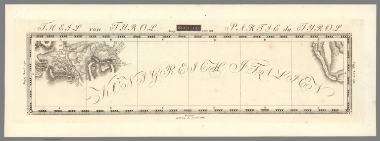
[Geographisches Institut (Weimar), Streit, Friedrich Wilhelm, 1772-1839]
Full Title
Sect. 191. Theil von Tyrol = Partie du Tyrol. Weimar, im Verlage des Geographischen Institut. (to accompany) Topographisch-militairische Charte von Teutschland : in 204 Sectionen ... 1807. = Carte topographique et militaire de L'Allemagne ... 1807-1813.
List No
11803.204
Note
Engraved map of part of Tylor. Relief shown by hachures and form lines.
Author
[Geographisches Institut (Weimar), Streit, Friedrich Wilhelm, 1772-1839]
Full Title
Sect. 196. Theil von Tyrol = Partie du Tyrol. Weimar, im Verlage des Geographischen Institut. (to accompany) Topographisch-militairische Charte von Teutschland : in 204 Sectionen ... 1807. = Carte topographique et militaire de L'Allemagne ... 1807-1813.
List No
11803.209
Note
Engraved map of Trient and environs, Tyrol. Relief shown by hachures and form lines.
Author
[Geographisches Institut (Weimar), Streit, Friedrich Wilhelm, 1772-1839]
Full Title
Sect. 197. Theil von Tyrol = Partie du Tyrol. Weimar, im Verlage des Geographischen Institut. (to accompany) Topographisch-militairische Charte von Teutschland : in 204 Sectionen ... 1807. = Carte topographique et militaire de L'Allemagne ... 1807-1813.
List No
11803.210
Note
Engraved map of Bassano and environs, Tyrol. Relief shown by hachures and form lines.
Author
[Geographisches Institut (Weimar), Streit, Friedrich Wilhelm, 1772-1839]
Full Title
Sect. 198. Theil der Illyrischen Provinzen = Partie des Provinces Illyriennes. Weimar, im Verlage des Geographischen Institut. (to accompany) Topographisch-militairische Charte von Teutschland : in 204 Sectionen ... 1807. = Carte topographique et militaire de L'Allemagne ... 1807-1813.
List No
11803.211
Note
Engraved map of Gorz and environs, Ilirske Province. Relief shown by hachures and form lines.
Author
[Geographisches Institut (Weimar), Streit, Friedrich Wilhelm, 1772-1839]
Full Title
Sect. 199. Theil der Illyrischen Provinzen = Partie des Provinces Illyriennes. Weimar, im Verlage des Geographischen Institut. (to accompany) Topographisch-militairische Charte von Teutschland : in 204 Sectionen ... 1807. = Carte topographique et militaire de L'Allemagne ... 1807-1813.
List No
11803.212
Note
Engraved map of Idria and environs, Ilirske Province. Relief shown by hachures and form lines.
Author
Darton, William
Full Title
Italy. Published May 21st 1811, by Wm. Darton Junr., Holborn Hill.
List No
4767.020
Note
Hand colored engraved map. Relief shown pictorially. Includes Corsica and the Dalmatian coast.
1-8 of 8
|