|
Author
[Coronelli, Vincenzo (1650-1718), Accademia cosmografica degli Argonauti.]
Full Title
(Text Page to) Isolario del P. Coronelli. (to accompany) Isolario descrittione geografico-historica, sacro-profana, antico-moderna ... e in supplimento dei XIV volumi del Bleau. Tomo II dell' Atlante veneto. Opera, e Studio del P. Maestro Vincenzo Coronelli ... A Spese dell Auttore MDCLXXXXVI (1696).
List No
11391.123
Note
Text to Isolario del P. Coronelli. Parte II.
Author
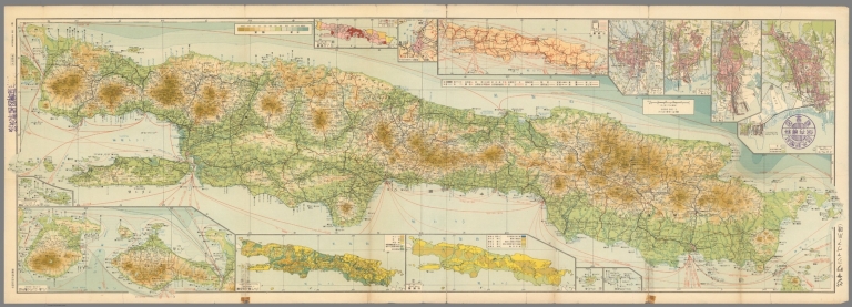
Topographisch Bureau (Batavia)
Full Title
Kaart der Residentie Besoeki. Topographisch Bureau te Batavia, April 1887. Chromo lithographie.
List No
11425.000
Note
Color topographic map. Shows administrative boundaries, rivers major cities and towns. Relief shown by contours and spot heights. Includes legend and index. Prime meridian is Greenwich.
Author
[Rossi, Giovanni Giacomo de, 1627-1691, Cantelli, Giacomo, 1643-1695, Rossi, Domenico de, 1647-1729, Widman, Giorgia]
Full Title
Isole dell' India cioe le Molucche, le Filippine e della Sonda : Parte de Paesi di nuoua scoperta e l' Isole de Ladri nel Mare del Zud : descritte da Giacomo Cantelli da Vignola, su l'Esemplare delle carte piu esatte con l'aggion: ta di nuoue notizie cauate da gl'itinerary modernii; e data in luce Da Gio : Giacomo de Rossi alla Pace con Priu. del S. Pont. 1683. Franus Donia Mefsis, Sculp. (To accompany) Mercurio geografico overo Guida geografica in tutte le parti del mondo conforme le tavole di Giacomo Cantelli da Vignola ... Tomo secondo ... l'anno 1692. (Map 178).
List No
11438.158
Note
Outline hand colored Detailed map of Southeast Asia and north coast of Australia, with decorative title cartouche. Relief shown pictorially. Shows administrative divisions, cities, towns, rivers and mountains. Includes notes. Pagination is not continuous, see the index.
Author
[Harrison, Richard Edes, St. Louis Post dispatch, Petruccelli , antonio]
Full Title
Indonesia : Question mark of the Far East. Special Atlas Section - St. Louis Post Dispatch. Sunday, September 12, 1954. Copyright, 1954. by Pulitzer Publishing Co.
List No
11507.007
Note
Color map, with descriptive text. Shows political and administrative divisions, and place names. Relief shown by shadings. Note "From a map by Antonio Petruccelli for TIME magazine.
Author
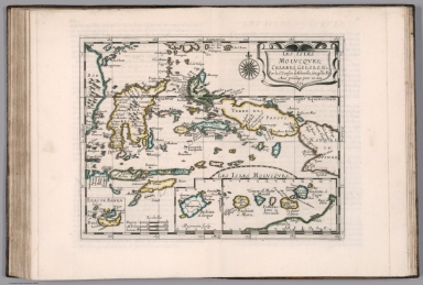
Sanson, Nicolas, 1600-1667
Full Title
Les Isles Molvcqves, Celebes, Gilolo, &c. Par le Sr. Sanson d'Abbeville, Geog. du Roy. Avec privilege pour 20 ans. 1652. A. Peyrounin sculp. (to accompany) L'Asie en plvsievrs cartes novvelles, et exactes ... A Paris, Chez l'Autheur ... (insets) Isles de Banda. (with) Les Isles Molucques. (with) Bachian ol Seque.
List No
11574.081
Note
Copper engraved double page, hand colored in outline map of East Indies, Celebes, Moluccas and New Guinea. Includes decorative cartouche and compass rose. Showing boundaries, major cities, towns, villages, rivers, mountains, drainage, etc. Relief shown pictorially.
Author
Sanson, Nicolas, 1600-1667
Full Title
Les Isles De La Sonde entre lesquelles sont Svmatra, Iave, Borneo, &c. Par le Sr. Sanson d'Abbeville, Geographe du Roy. Avec privil. pour 20 ans. 1652. A. Peyrounin sculp. (to accompany) L'Asie en plvsievrs cartes novvelles, et exactes ... A Paris, Chez l'Autheur ...
List No
11574.0835
Note
Copper engraved double page, hand colored in outline, with decorative cartouche. Covers Indonesia and the area from the Malay Peninsula and Borneo in the north to Java and the Sonda Straits in the south. Showing boundaries, major cities, towns, villages, rivers, mountains, drainage, etc. Relief shown pictorially.
Author
[Sohr, Karl, Berghaus, Heinrich, 1797-1884, Handtke, Friedrich, 1815-1879, Klein, H.J.]
Full Title
Hinter-Indien und Ostindische Inseln. Druck und Verlag von C. Flemming in Glogau. (to accompany) Sohr-Berghaus Hand-Atlas uber alle Theile der Erde. Neu bearbeitet von F. Handtke, Achte vermehrte und verbesserte Auflage. No. 79. (inset) Mergui Archipel.
List No
11640.087
Note
Outline color lithograph engraving double page map, color coded by region. Relief shown by hachures. Prime meridians are Greenwich, Paris and Ferro. Includes legend and tables.
Author
[Sohr, Karl, Berghaus, Heinrich, 1797-1884, Handtke, Friedrich, 1815-1879, Klein, H.J.]
Full Title
China und Japan. Druck und Verlag von C. Flemming in Glogau. (to accompany) Sohr-Berghaus Hand-Atlas uber alle Theile der Erde. Neu bearbeitet von F. Handtke, Achte vermehrte und verbesserte Auflage. No. 80.
List No
11640.088
Note
Outline color lithograph engraving double page map, color coded by region. Relief shown by hachures. Prime meridians are Greenwich, Paris and Ferro. Includes legend and tables.
Author
Meyer, Joseph, 1796-1856
Full Title
Asiatische Archipel und Neu Holland 1849. Stahlstich (Direction v. Kleinknecht) aus der Schweinfurter Geographischen Graviranstalt des Bibliographischen Instituts zu Hildburghausen, Amsterdam, Paris u. Philadelphia. (in upper margin) Meyer's Zeitung Atlas. No. 15. (to accompany) Neuester Zeitungs-Atlas fur Alte und Neue Erdkunde. Herausgegeben von J. Meyer. (insets) Neu-Sud-Wales. (with) Sudwestspitze vom Austram lande.
List No
11652.089
Note
Engraved outline hand color map. Shows political boundaries, cities and towns. Relief shown by hachures. Depth shown by isolines. Includes colored coded European possessions in the region.
Author
Fer, Nicolas de, 1646-1720
Full Title
Plan de Batavia. (to accompany) Les forces de l'Europe ... Le tout recueilli par les soins du Sr. de Fer ... Septieme partie. A Paris, chez l'auteur dans l'Isle du palais. M. DC. XCVI (1696).
List No
11668.176
Note
Engraved plan of the city of Jakarta, the Dutch colonial capital. Shows roads, rivers, bridges and buildings. Includes compass rose. The title and key cartouche appears in drape form, and refers important sites.
Author
Visscher, Nicolaes, 1649-1702.
Full Title
Indiae Orientalis nec non Insularum Adiacentium Nova Descriptio, Per Nicolaum Visscher. (to accompany) Atlas minor sive totius orbis terrarum contracta delinea ex conatibus Nico. Visscher. 1690. (half title page) Atlas Minor sive Geographia Compendiosa, qua Orbis Terrarum.
List No
11755.116
Note
Hand colored in outline engraved map, covers Northeast Asia. Map shows political and administrative boundaries, cities, towns, waterways, canals, landmarks, lakes and mountains. Includes decorative carouche and compass rose. Relief shown pictorially.
Author
Wilkinson, Robert
Full Title
The Islands of the East Indies with the Channels between India, China & New Holland.
List No
1201.045
Author
Wilkinson, Robert
Full Title
The Islands of the East Indies with the Channels between India, China & New Holland.
List No
1202.046
Author
[Harrison, Richard Edes, Army Orientation Course. Special Service Division Army Service Forces]
Full Title
Land of the Setting Sun. Prepared and Distributed by the Army Orientation Course. Morale Services Division, Army Service Forces, War Dept.,2E581 Pentagon Bldg., Washington D.C. U.S. Government Printing Office: 1943 - 538110. Eastern Front. Southwest New Britain. Netherlands Indies.
List No
12026.001
Author
[Santini, Paolo, Robert]
Full Title
37. Archipel des Indes Orientales.
List No
12039.118
Author
[Brue, Picquet, Chles.]
Full Title
Carte du Grand Archipel D'Asie.
List No
12050.054
Author
Speed, John, 1542-1629
Full Title
A New Map of East India.
List No
12058.219
Author
[Bellin, Jacques Nicolas, 1703-1772, Depot de la Marine]
Full Title
Carte Reduite des Detroits de Malaca, Sincapour, et du Gouverneur.
List No
12059.129
Note
From J.F. Letenneur: "Exceptional onboard document of this rare and fabulous maritime atlas, a masterpiece by the greatest French hydrographer of the 18th century, with maps of all the coastlines known at the time. Bound with the coat of arms of the King of France, the atlas was taken by the English aboard the frigate la Nymphe, off the coasts of Ushant August 10, 1780, during one of the naval battles of the American War of Independence which took place on European waters. In the context of the war at the end of the 18th century, and of the rivalry between the French and British Navy, maritime atlases, were strategic tools, and this “Hydrographie Françoise” more so than any other, because its purpose was to provide the best maritime charts for the French ships that were fighting on the American side against the British. (The handwritten captions throughout most of the atlas are prices for individual maps and all include the same mention: “for sailors”). These atlases were not the kind to be kept in a library, but precious tools, based on the observations of the travelers and continuously improved upon, as reflect in the present copy. It was bound with the engraved title page of the edition of 1737-1765, but the index includes maps printed after 1765 (until 1772), and the copy was augmented by six maps that do not appear in the index (until 1776), as well as 14 pages of text from the Versailles edition of 1773. The later maps are signed by Verdun de la Crenne and were done during the campaigns of the Flore (1771-1772) and of the Isis led by Fleurieu in 1768-1769. The captions explain that the maps were created using the latest technology of the day that could measure longitude (maritime clocks)." (Continued in the Pub Note field).
Author
Heck, Johann Georg, 1795 -1857
Full Title
61. Carte Generale de l'Austalie et du Grand Archipel d'Asie.
List No
12128.065
Author
[Jaillot, Alexis Hubert, 1632?-1712, Mortier, Pierre, Sanson, Nicolas, 1600-1667]
Full Title
Troisieme Partie de l'Asie.
List No
12178.204
Author
[Jaillot, Alexis Hubert, 1632?-1712, Mortier, Pierre, Sanson, Nicolas, 1600-1667]
Full Title
Le Royaume de Siam.
List No
12178.207
Author
Goos, Pieter, 1616-1675
Full Title
Paskaerte Zunde t'Oosterdeel Van Oost Indien.
List No
12179.033
Note
North to the left.
Author
[Ewald, Ludwig 1813-1881, Bauerkeller, Georg Leonhart]
Full Title
No. 68. Ostindien und die ostindischen Inseln.
List No
12189.102
Author
[Handtke, F., Flemming, Carl, Sohr, Karl]
Full Title
Die Ostindischen Inseln.
List No
12206.071
Author
Marmocchi, Francesco C.
Full Title
16. Le Isole della Sonda, Borneo, Sumatra, Giava, Celebes e le Molucche.
List No
12235.017
Author
Stieler, Adolf
Full Title
64. Ostindische Inseln. (inset) Java. Die Strassen. Atjeh oder Atschin. Batavia.
List No
12240.077
Author
[Stieler, Adolf, Haack, H.]
Full Title
72. Malaiische Inselwelt. (insets) Riukiu - Inseln. Hanoi. Der Canton-Strom.
List No
12248.153
Author
[Stieler, Adolf, Haack, H.]
Full Title
73. Ostindische Inseln. (insets) (Various East Indian island groups).
List No
12248.155
Author
Chapin, Jr., R.M.
Full Title
Blood on Four Flags.
List No
12391.000
Author
[Boisseau, Jean, Jollain, G.]
Full Title
Les Isles des Indes Orientalle.
List No
12496.031
Author
[Schraembl, Franz Anton, D'Anville]
Full Title
13. Zweiter Theil der Karte von Asien, (southern sheet) welcher China, einen Theil der Tartarei, Indien jenseits des Ganges, die Inseln Sumatra, Java, Borneo, Moluken, Philippinen und Japon enthaet Verfass von Herrn D'Anville Nach den neueesten Karten Verbessert herausgegeben von Herrn F.A. Schraembl. MDCCLXXXVI.
List No
12498.027
Author
Du Val, Pierre, 1619-1683
Full Title
Isles de La Sonde.
List No
12503.264
Author
Du Val, Pierre, 1619-1683
Full Title
Isles Molucques.
List No
12503.276
Author
[Depot General de la Marine, Apres de Mannevillette, Jean-Baptiste-Nicolas-Denis d', 1707-1780]
Full Title
Plan de la rade d'Achem et des Isles Circonvoisines situees a la partie du nord-ouest de Sumatra. Guil. de-la-Haye. (to accompany) Neptune Oriental. De d'Apres.
List No
13102.051
Note
Charts of the Aceh coast on the northwestern Sumatra, with a profile view. Depth shown by soundings. Relief shown pictorially.
Author
[Depot General de la Marine, Apres de Mannevillette, Jean-Baptiste-Nicolas-Denis d', 1707-1780]
Full Title
Carte plate de la partie septentrionale du detroit de Malac, depuis la rade d'Achem jusqu'a Malac. (to accompany) Neptune Oriental. De d'Apres.
List No
13102.052
Note
Charts of the Malacca Strait and Malay Peninsula. Depth shown by soundings. Includes notes.
Author
[Depot General de la Marine, Apres de Mannevillette, Jean-Baptiste-Nicolas-Denis d', 1707-1780]
Full Title
Nouveau plan des Detroits, situes a l'Est de Java et de Madura. Guill. De-la-Haye. (inset) Plan de la Baye de Ballambouang. (to accompany) Neptune Oriental. De d'Apres.
List No
13102.058
Note
Charts of the straits in the East of Java and Madura, with 2 profile views. Depth shown by soundings. Includes notes.
Author
[Depot General de la Marine, Apres de Mannevillette, Jean-Baptiste-Nicolas-Denis d', 1707-1780]
Full Title
Carte pour aller du Detroit de la Sonde ou de Batavia au Detroit de Banca. (inset) Plan des Isles Remouw, Kandang, High et Voody, situees au sud-est de l'isle Sumatra, au detroit de la Sonde. (to accompany) Neptune Oriental. De d'Apres.
List No
13102.059
Note
Charts of the coast of East Sumatra and North-West of Java. Depth shown by soundings.
Author
[Depot General de la Marine, Apres de Mannevillette, Jean-Baptiste-Nicolas-Denis d', 1707-1780]
Full Title
Plan du Detroit de Banca. Guill. De-La-Haye. (inset) Petit plan du detroit a l'est de Banca. (to accompany) Neptune Oriental. De d'Apres.
List No
13102.060
Note
Charts of the Strait of Bangka, with a profile view of the Monopin Mountain. Depth shown by soundings.
Author
Luffman, John, 1756-1846
Full Title
Batavia. Engraved for Luffman's Select plans. Engrav'd & Publish'd Feby. 1.1802, by J. Luffman. London.
List No
13189.145
Note
Hand colored plan. Prime meridian is London. Includes historical text at the foot of map and key to the important sites.
Author
[Lizars, William Home, 1788-1859, Lizars, Daniel]
Full Title
East India. Published by T. Brown & W. & D. Lizars, Edinburgh. (to accompany) New Edinburgh general atlas ... The maps drawn and engraved by W. & D. Lizars.
List No
13230.046
Note
Hand colored engraved map. Relief shown by hachures and pictorially. Prime meridian is Greenwich.
Author
Arrowsmith, Aaron
Full Title
Chart of the Indian Ocean, drawn from a variety of charts, plans, journals etc., both M. S. S. and printed by A. Arronsmith. 1802. Additions to ... 1812. London. Published May 24th., 1802, by A. Arrowsmith, 10 Soho Square. (inset) Chart of the N. W. part of New Holland.
List No
13270.002
Note
Nautical chart of Indian Ocean, published in 4 sheets, the library lacks Northwest sheet No. 1. Depth shown by soundings. Relief shown by hachures. Prime meridian is Greenwich. Includes notes about routes and islands. Title from Northeast sheet.
Author
[Chatelain Henri, 1684-1743, Gueudeville, Nicolas]
Full Title
Vue et description de surate et de Batavia. Tom. V. No. 46. Pag. 128. ((to accompany) Atlas Historique ... Tom. V. A Amsterdam, chez L'Honore & Chatelain Libraires. M DCC XIX (1719).
List No
13272.562
Note
Engraved plan of Jakarta, with view of town and harbor of Surate on the northwest coast of India. Includes descriptive text.
Author
[Chatelain Henri, 1684-1743, Gueudeville, Nicolas]
Full Title
Carte de l'Ile de Java: partie Occidentale, partie Orientale, Dressee tout nouvellement sur les Memoirs les plus exacts ... Tom. V. No. 47. Pag. 128. ((to accompany) Atlas Historique ... Tom. V. A Amsterdam, chez L'Honore & Chatelain Libraires. M DCC XIX (1719).
List No
13272.563
Note
Engraved folded map of Java, Madura and part of Sumatra, with inset map: Le port de Batavia. Covers the island in full as well as adjacent parts of Sumatra and Bali. Shows rice plantations, mountain ranges, forests and landmarks. Includes table of the principal towns, compass rose and descriptive text.
Author
[Chatelain Henri, 1684-1743, Gueudeville, Nicolas]
Full Title
Le Royaume de Siam avec les Royaumes qui luy sont Tributaires et les Isles de Sumatra, Andemaon etc ...Tom. V. No. 57. Pag. 173. (to accompany) Atlas Historique ... Tom. V. A Amsterdam, chez L'Honore & Chatelain Libraires. M DCC XIX (1719).
List No
13272.596
Note
Engraved map of Southeast Asia, extending from Thailand, Cambodia, Vietnam, and the Malay Peninsula and Gulf of Bengal in the North to Java and Sumatra in the South, centered on Malacca and Borneo. Shows exploration routes, major cities and towns. Relief shown pictorially.
Author
Andriveau-Goujon, Eugene
Full Title
Asie Orientale comprenant L'Empire Chinois et le Japon, les Etats de L'Indo-Chine et le Grand Archipel d'Asie. (to accompany) Atlas classique et universel de geograparphie ancienne et moderne ... Nouvelle edition. 1863.
List No
13421.049
Note
1 hand color map on 2 sheets. Northern part of East Asia. Title from sheet 39. Shows political boundaries. Relief shown by hachures.
Author
Andriveau-Goujon, Eugene
Full Title
Asie Orientale comprenant L'Empire Chinois et le Japon, les Etats de L'Indo-Chine et le Grand Archipel d'Asie. (to accompany) Atlas classique et universel de geograparphie ancienne et moderne ... Nouvelle edition. 1863.
List No
13421.050
Note
1 hand color map on 2 sheets. Southern part of East Asia. Title from sheet 39. Shows political boundaries. Relief shown by hachures.
Author
Andriveau-Goujon, Eugene
Full Title
Oceanie. Paris - 1862. E. Andriveau-Goujon. Rue du Bac. 21. Impie. de Louis Antoine. Gravee par Melle. Flauhaut et Smith ; les ecritures par P. Rousset ; les eaux par Mme. Fontaine. (to accompany) Atlas classique et universel de geograparphie ancienne et moderne ... Nouvelle edition. 1863.
List No
13421.053
Note
Hand color map of Oceania. Relief shown by hachures. Includes color coded reference to European colonies.
Author
Giamusho Nan'yō- Kyoku
Full Title
ジャワ = Jawa. Giamusho Nan'yō- Kyoku. Showa 17 (1942).
List No
13492.000
Author
[Sydow, Emil von., 1812-1873, Wagner, Hermann, 1840-1929]
Full Title
Japan und Indonesien. Gotha : Justus Perthes. Sydow-Wagners method. Schul-Atlas. XXI.
List No
13557.125
Note
2 maps on 1 sheet. with insets: Java; Singapur; Tokyo. Lambert Azimuthal equal-area projection.
Author
[Sydow, Emil von., 1812-1873, Wagner, Hermann, 1840-1929]
Full Title
Japan und Indonesien. Gotha : Justus Perthes. Sydow-Wagners method. Schul-Atlas. XXII.
List No
13558.126
Note
2 maps on 1 sheet. with insets: Java; Singapur; Tokyo. Lambert Azimuthal equal-area projection.
|