|
REFINE
Browse All : Images of Indiana and Illinois
1-44 of 44
Author
Burr, David H., 1803-1875
Full Title
Map of the northern parts of Ohio, Indiana and Illinois with Michigan and that part of the Ouisconsin territory lying east of the Mississippi River
List No
15634.000
Author
[Brown, Constance, Widmer, Ted]
Full Title
Lincoln's Odyssey. "to travel sea and land, as fast as wind." Hom Od. 1:99
List No
15608.000
Note
This map was a collaboration between author Ted Widmer and Connie Brown to create map end papers for Widmer's Book "Lincoln on the Verge: Thirteen Days to Washington," published in 2020.
Author
Ensign & Thayer
Full Title
Pictorial Map of the Great West.
List No
15332.000
Author
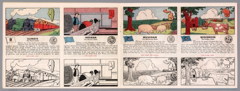
[Fisher, Joseph R., Planters Peanuts (Firm)]
Full Title
Illinois : The prairie state -- Indiana : The hoosier state -- Michigan : The wolverine state -- Wisconsin : The badger state.
List No
14374.009
Note
Four views, representing Illinois, Indiana, Michigan and Wisconsin. Views show examples of the landscape and natural resources. Each view includes an inset map of the state, which marks the location of the capital city with a star. Accompanied by descriptive text, the state flags, seals and flowers: violet, zinnia, apple blossom and violet, respectively. The view of each state appears both in color (on top) and in black and white (bottom), the latter inviting coloration. Together, views are 18 x 52 cm, on two sheets 20 x 54 cm.
Author
[Bartholomew, John, Black, Adam & Charles]
Full Title
Ohio, Indiana & Illinois. Published by A. & C. Black. Edinburgh. Printed in Colours by Schenck & Macfariane. Edinburgh. Drawn & Engraved by J. Bartholomew, Edinburgh.
List No
0073.008
Note
States outlined in color. Land tinted.
Author
Finley, Anthony
Full Title
Map of the States Of Ohio Indiana & Illinois And Part Of Michigan Territory Compiled from the Latest Authorities. D.H. Vance Del. J.H. Young Sc. Philada. Published by A. Finley 1825.
List No
0278.011
Note
In full color by county or region of the state. Statistical information includes mileage, population broken down by White Males, White Females, Free People of Colour, Slaves and Militia.
Author
Finley, Anthony
Full Title
Map of the States of Ohio, Indiana & Illinois and Part of the Michigan Territory, Complied from the Latest Athorities.
List No
0279.015
Author
Finley, Anthony
Full Title
Map of the States of Ohio, Indiana, & Illinois, and Part of the Michigan Territory, Compiled from the Latest Authorities. D.H. Vance Del., Philada. Published by A. Finley 1827. J.H. Young Sc.
List No
0280.011
Note
Relief shown by hachures. Prime meridian Washington. Statistical table for each state.
Author
Mitchell, Samuel Augustus
Full Title
(Covers to) Map of the States Of Ohio, Indiana And Illinois with the settled part of Michigan. Published by S. Augustus Mitchell Philadelphia: 1834. Sold by Mitchell & Hinman No. 6 North 5th St. Entered ... 1834 by S. Augustus Mitchell ... Pennsylvania. Engraved by J.H. Young. (inset) Lead Region East of the Mississippi River. (inset) Falls Of Ohio. (inset) Vicinity Of Cincinnati. (inset) Vicinity Of Detroit.
List No
0514.001
Note
Updated version of Finley American Atlas map of 1825; changes from the 1831 Mitchell issue include the four inset maps, moving the title to the lower right, a table of Steamboat Routes, and new counties throughout. Folded into dark green leather covers 13.5x8 with "Mitchell's Map Of Ohio, Indiana, Illinois & Michigan." and a decorative border stamped in gilt. Full color. Prime meridian is Washington D.C.
Author
Mitchell, Samuel Augustus
Full Title
Map of the States Of Ohio, Indiana And Illinois with the settled part of Michigan. Published by S. Augustus Mitchell Philadelphia: 1834. Sold by Mitchell & Hinman No. 6 North 5th St. Entered ... 1834 by S. Augustus Mitchell ... Pennsylvania. Engraved by J.H. Young. (inset) Lead Region East of the Mississippi River. (inset) Falls Of Ohio. (inset) Vicinity Of Cincinnati. (inset) Vicinity Of Detroit.
List No
0514.002
Note
Updated version of Finley American Atlas map of 1825; changes from the 1831 Mitchell issue include the four inset maps, moving the title to the lower right, a table of Steamboat Routes, and new counties throughout. Folded into dark green leather covers 13.5x8 with "Mitchell's Map Of Ohio, Indiana, Illinois & Michigan." and a decorative border stamped in gilt. Full color. Prime meridian is Washington D.C.
Author
Society for the Diffusion of Useful Knowledge (Great Britain)
Full Title
North America sheet IX. Parts of Missouri, Illinois and Indiana. Published under the superintendence of the Society for the Diffusion of Useful Knowledge. Engraved by J. & C. Walker. Published July 1st. 1833 by Baldwin & Cradock, 47 Paternoster Row, London. Printed by Russell, Penge. (London: Chapman & Hall, 1844)
List No
0890.136
Note
Engraved map. Relief shown by hachures. County boundaries hand col. Source: Tanner.
Author
U.S. General Land Office
Full Title
(Map 7 - Iowa, Indiana, Illinois, Michigan, Wisconsin, Minnesota, Missouri).
List No
1071.009
Note
One of the series of adjacent sixteen maps. Mounted on linen.
Author
Meyer, Joseph, 1796-1856
Full Title
Die staaten von Missouri, Illinois, Indiana, Ohio,Kentucky & Tennessee 1850. United States of North America. Stahlstich (Direction v. Kleinknecht) aus der Schweinfurter Geographischen Graviranstalt des Bibliographischen Instituts zu Hildburghausen, Amsterdam, Paris und Philadelphia. (in upper margin) Meyer's Zeitung Atlas. No. 68. (to accompany) Neuester Zeitungs-Atlas fur Alte und Neue Erdkunde. Herausgegeben von J. Meyer. (insets) Cincinnati. (with) Nashville. (with) Lexington.
List No
11652.096
Note
Engraved outline hand color map of the American Midwest. Shows administrative boundaries, cities and towns. Relief shown by hachures. Prime meridians are Greenwich and Washington.
Author
Smith, Karl
Full Title
Abraham Lincoln,1809-1865 : A pictorial outline of the life of the sixteenth president of the United States. Karl Smith, Jan. 1934. Copyrighted 1934 by John Speed and Karl Smith, Louisville, Kentucky. Historical data by John Speed.
List No
13411.000
Author
[Black, Adam, Black, Charles]
Full Title
Illinois, Indiana & Ohio.
List No
1585.073
Author
[Julius Bien & Co., United States. War Department]
Full Title
General topographical map. Sheet XV. Julius Bien & Co., Lith., N.Y. (1891-1895)
List No
1780.153
Note
Col. map. Relief shown by hachures. Shows settlements, railroads, roads, ferries, etc.
Author
[Julius Bien & Co., United States. War Department]
Full Title
General topographical map. Sheet XVI. Julius Bien & Co., Lith., N.Y. (1891-1895)
List No
1780.154
Note
Col. map. Relief shown by hachures. Shows settlements, railroads, roads, ferries, etc.
Author
[Birkbeck, Morris, Melish, John]
Full Title
English Prairie and Adjacent Country. T.V.K & Co. Sc. J. Melish Del.
List No
2666.002
Note
An uncolored map showing the townships in Illinois and Indiana.
Author
Carey, Mathew
Full Title
The Upper Territories of the United States. Kneass & Delleker Sc.
List No
2721.030
Note
Outline color by territory. U.S. land is marked. Prime meridians Philadelphia and London. Relief shown by hachures.
Author
Mitchell, Samuel Augustus
Full Title
(Covers to) Map of the States Of Ohio, Indiana And Illinois with the settled part of Michigan. Published by S. Augustus Mitchell Philadelphia: 1837. Sold by Mitchell & Hinman No. 6 North 5th St. Entered ... 1834 by S. Augustus Mitchell ... Pennsylvania. Engraved by J.H. Young. (inset) Lead Region East of the Mississippi River. (inset) Falls Of Ohio. (inset) Vicinity Of Cincinnati. (inset) Vicinity Of Detroit.
List No
2843.001
Note
Many changes from the 1834 issue: Lake Michigan has been redrawn, new counties in Indiana (Porter, Newton, Jasper, etc.), and a curious extension of Wisconsin Territory appears in place of Iowa. Full color map is folded into black leather covers 13.5x8 with "Mitchell's Map Of Ohio, Indiana, Illinois & Michigan." in gilt. Inside the front cover "Census, 1830" for all four states. Prime meridian is Washington D.C.
Author
Mitchell, Samuel Augustus
Full Title
Map of the States Of Ohio, Indiana And Illinois with the settled part of Michigan. Published by S. Augustus Mitchell Philadelphia: 1837. Sold by Mitchell & Hinman No. 6 North 5th St. Entered ... 1834 by S. Augustus Mitchell ... Pennsylvania. Engraved by J.H. Young. (inset) Lead Region East of the Mississippi River. (inset) Falls Of Ohio. (inset) Vicinity Of Cincinnati. (inset) Vicinity Of Detroit.
List No
2843.002
Note
Many changes from the 1834 issue: Lake Michigan has been redrawn, new counties in Indiana (Porter, Newton, Jasper, etc.), and a curious extension of Wisconsin Territory appears in place of Iowa. Full color map is folded into black leather covers 13.5x8 with "Mitchell's Map Of Ohio, Indiana, Illinois & Michigan." in gilt. Inside the front cover "Census, 1830" for all four states. Prime meridian is Washington D.C.
Author
Mitchell, Samuel Augustus
Full Title
Map of the States Of Ohio, Indiana And Illinois with the settled part of Michigan. Published by S. Augustus Mitchell Philadelphia: 1837. Sold by Mitchell & Hinman No. 6 North 5th St. Entered ... 1834 by S. Augustus Mitchell ... Pennsylvania. Engraved by J.H. Young. (inset) Lead Region East of the Mississippi River. (inset) Falls Of Ohio. (inset) Vicinity Of Cincinnati. (inset) Vicinity Of Detroit.
List No
2843.003
Note
Many changes from the 1834 issue: Lake Michigan has been redrawn, new counties in Indiana (Porter, Newton, Jasper, etc.), and a curious extension of Wisconsin Territory appears in place of Iowa. Full color map is folded into black leather covers 13.5x8 with "Mitchell's Map Of Ohio, Indiana, Illinois & Michigan." in gilt. Inside the front cover "Census, 1830" for all four states. Prime meridian is Washington D.C.
Author
Page, H.R. & Co.
Full Title
(Index Pages) Guide to Illinois (continued). Guide to Indiana.
List No
2871.006
Author
Fullarton, A. & Co.
Full Title
United States North America According to Calvin, Smith & Tanner. By G.H. Swanston Edinr. The North Central Section Comprising Michigan, Illinois, Wisconsin, Iowa, Indiana, Nebraska, Minnisota (sic), and part of Missouri & Kentucky. LVII. Engraved by G.H. Swanston Edinburgh. A. Fullarton & Co. Edinburgh, London & Dublin.
List No
3007.058
Note
In full color. Township lines are shown throughout the map.
Author
[U.S. Army Corps of Engineers, Moser, C.]
Full Title
No. 47-48: Map Of The Ohio River, Reduced from the following surveys ... 1837-8, Lieut. Sanders ... 1844, C.A. Fuller ... 1867-8, W.M. Roberts ... Made under the direction of Major W.E. Merrill, Corps of Engineers, By C. Moser.
List No
3070.040
Note
Two uncolored maps. Showing roads, towns, streets, blocks, etc. Relief shown by hachures.
Author
Smith, J. Calvin
Full Title
(Illinois, Indiana, Ohio).
List No
3471.006
Note
Estimated Date. Part of a sixteen piece map combined digitally as a composite in final map of series.
Author
Mitchell, Samuel Augustus
Full Title
Map of the States Of Ohio, Indiana & Illinois And Part Of Michigan Territory Compiled from the Latest Authorities. Published by S. Augustus Mitchell Philadelphia. 1831. J.H. Young Sc.
List No
3884.011
Note
Full color by county or territory.
Author
National Map Company
Full Title
Illinois. (Copyrighted by) National Map Company, Indianapolis. (Scale 1:1,800,000) (inset) Chicago. Indiana. (Copyrighted by) National Map Company, Indianapolis. (Scale 1:1,300,000) (insets) Lake Co. ; Marion Co. (to accompany) Official Paved Road and Commercial Survey of the United States.
List No
4048.028
Note
2 outline color maps on 2 pages, with insets. Shows administrative divisions, roads, rivers, etc. Prime meridian is Greenwich.
Author
[Walling, Henry Francis, 1825-1888, Lloyd, H.H.]
Full Title
Railroad map of Ohio, Indiana and Illinois. Published for Henry S. Stebbins By H.H. Lloyd & Co. New York. (to accompany) Atlas Of The State Of Ohio. 1868.
List No
4726.036
Note
Hand colored map. Shows counties, roads, railroads, canals, cities and towns for Ohio, Indiana and Illinois. Relief shown by hachures.
Author
[Hammond, John T., Squire, B.S.]
Full Title
Travellers guide & emigrants directory, through the states of Ohio, Illinois, Indiana and Michigan. Entered ... Southern District of the state of New-York, in the year 1836, by H. Phelps & B.S. Squire, Jun.
List No
4877B
Note
Gives population statistics, history and general information as well as advice for emigrants.
Author
Rand McNally and Company
Full Title
(Text Page) Industrial Statistics of the United States. Idaho. Illinois. Indiana.
List No
5028Y
Note
Industrial statistics by state and county including county seat, area, and statistics on population, agriculture and manufacturing. Includes descriptions of mines, quarries, and wells.
Author
Rand McNally and Company
Full Title
Commercial Atlas of America. Rand McNally AutoTrails Map, District Number 1. Illinois, Western Indiana, S.E. Iowa, N.E. Missouri.
List No
5028.088
Note
Shows roads and distances. Shows table of highway names, numbers, and markings.
Author
Strong, Ezra
Full Title
The States Of Ohio Indiana & Illinois And Michigan Territory From the Latest Authorities. Published by Ezra Strong New York, 1835.
List No
5059.000
Note
The third edition, with La Porte and La Grange counties added in northern Indiana. This copy lacking the covers. Full color by county, with alphabetical list of counties and population. Includes Explanatory remarks. Prime meridian is Washington, D.C.
Author
Strong, Ezra
Full Title
(Covers to) The States Of Ohio Indiana & Illinois And Michigan Territory From the Latest Authorities. Published by Ezra Strong New York 1834.
List No
5145.001
Note
Second edition. This map is almost a copy of the Young/Mitchell map of similar title (see our #514) but it is from an entirely new plate, and has a different title and three tables of population that are not present in the source map. Karrow lists editions of 1833, 1835, and 1836. Strong published a Map of the United States, Hartford, 1837 (Karrow 1-1499) with another edition in 1847 issued by House and Brown of Hartford.
Author
Strong, Ezra
Full Title
The States Of Ohio Indiana & Illinois And Michigan Territory From the Latest Authorities. Published by Ezra Strong New York 1834.
List No
5145.002
Note
Second edition. This map is almost a copy of the Young/Mitchell map of similar title (see our #514) but it is from an entirely new plate, and has a different title and three tables of population that are not present in the source map. Karrow lists editions of 1833, 1835, and 1836. Strong published a Map of the United States, Hartford, 1837 (Karrow 1-1499) with another edition in 1847 issued by House and Brown of Hartford.
Author
Letts, Son & Co.
Full Title
Eastern United States. No. 5. Letts's popular atlas. Letts, Son & Co. Limited, London. (1883)
List No
5371.122
Note
Colored map. The 10-sheet set shows cities, British consular offices, railroads, canals, roads, lights and lighthouses, relief by hachures, etc. This sheet covers parts of Illinois, Indiana, Iowa and Missouri.
Author
G.W. & C.B. Colton & Co.
Full Title
Maps showing the Indiana & Illinois Central Railway. And Its Connections. Prepared By G.W. & C.B. Colton & Co. 172 William Street New York. Entered ... 1872 by G.W. & C.B. Colton & Co. ... Washington. (with) Untitled inset map of railway connections from the Eastern Seaboard to Colorado and Wyoming.
List No
5439.000
Note
Outline hand coloring with rail lines highlighted in blue and red. Fingers point the way on the large map to New York, Boston, Philadelphia, Baltimore and Norfolk.
Author
[Kensett, T., Shelton, W.]
Full Title
Shelton & Kensett's Map Of The State Of Indiana. Protracted from manuscript surveys communicated to the publishers By the Honorable Christopher Harrison. Lieut. Govr. of that State, to which are added the surveys of the Illinois Territory By Genl. Mansfield. Engraved by A. Doolittle, New Haven. (with) A Sketch of the existing connection of the State of Indiana and Illinois Territory, with the adjoining States. Entered ... 25th day of Decr. 1817 by Shelton & Kensett.
List No
5522.000
Note
In outline color by county. Shows townships for Indiana and Illinois.
Author
W. & A.K. Johnston Limited
Full Title
Illinois, Indiana, Ohio, Kentucky.
List No
6921.124
Author
[United Air Lines, White, Ruth Taylor]
Full Title
Iowa City - Chicago. Chicago - Toledo.
List No
7824.007
Note
Date estimated.
Author
[Hader, Berta Hoerner (1890-1976), Hader, Elmer Stanley (1889-1973]
Full Title
Illinois. Indiana.
List No
8763.034
Author
Smith, Karl
Full Title
Abraham Lincoln, 1809-1865. (Indiana, Kentucky, Illinois.)
List No
8893.000
Note
Vignettes and labels pertaining to this homeland of President Lincoln. Inset of the Gettysburg Address. Portrait of Lincoln.
Author
Smith, Karl
Full Title
1809-1865,Abraham Lincoln, A Pictorial Outline of the Life of the Sixteenth President of the United States. (Indiana, Kentucky, Illinois.)
List No
8894.000
Note
Vignettes and labels pertaining to this homeland of President Lincoln. Portrait of Lincoln.
Author
Taintor Brothers & Merrill
Full Title
Map of Ohio, Indiana, Illinois, and Kentucky.
List No
9731.014
1-44 of 44
|