|
Author
Lindgren - Turner Co.
Full Title
A Hysterical Map Of Idaho. It's Got Everything and Plenty Of It.
List No
15999.001
Author
United States. Post Office Department
Full Title
Post Route Map of the States of Montana, Idaho, and Wyoming. Frank H. Hitchcock... David M. Hildreth.
List No
15912.002
Author
United States. Post Office Department
Full Title
(Composite map to) Post Route Map of the States of Montana, Idaho, and Wyoming. Frank H. Hitchcock... David M. Hildreth.
List No
15912.003
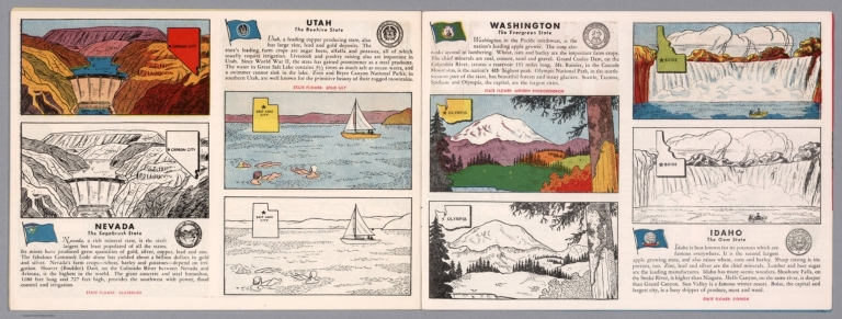
Author
[Fisher, Joseph R., Planters Peanuts (Firm)]
Full Title
Nevada : The sagebrush state -- Utah : The beehive state -- Washington : The evergreen state -- Idaho : The gem state.
List No
14374.015
Note
Four views, representing Nevada, Utah, Washington and Idaho. Views show examples of the landscape and natural resources. Each view includes an inset map of the state, which marks the location of the capital city with a star. Accompanied by descriptive text, the state flags, seals and flowers: sagebrush, sego lily, western rhododendron and syringa, respectively. The view of each state appears both in color (on top) and in black and white (bottom), the latter inviting coloration. Together, views are 18 x 52 cm, on two sheets 20 x 54 cm.
Author
Fremont John Charles, 1813-1890
Full Title
(Emigrant route in Bear River Valley). Lith. by E. Weber & Co. Baltimore. (to accompany) Report of The Exploring Expedition to The Rocky Mountains in the Year 1842, and to Oregon & North California In The Years 1843-44. By Brevet Capt. J. C. Fremont ... Washington : Gales and Seaton, Printers. 1845.
List No
13406.013
Note
Untitled folded map of emigrant route in Bear River Valley. Relief shown by hachures. Oriented with the north to upper right.
Author
Union Pacific Railway Company.
Full Title
World's pictorial line : birdseye view of the great Salt Lake Basin reached via the Union Pacific, the overland route. Knight, Leonard & Co., Printers and engravers, Chicago, Ill. Copyrighted. 1893, by E.L. Lomax, General passenger and ticket agent, Union Pacific System, Omaha, Neb.
List No
13206.003
Note
Color pictorial map, on sheet 114 x 45, folded to 23 x 10. Title from cover, with 28 pages of text. On verso 24 pages of text "Sights and scenes in Idaho and Montana", on recto text pages 25-28. Includes logo of "Union Pacific, the overland route" on cover. Map shows major cities, routes, rivers and mountains. Relief shown pictorially.
Author
[Weiland, Carl Ferdinand, 1782 -1847, Hassel, Georg, 1770-1829]
Full Title
Geographisch-statistische und historische Charte von Missouri und Oregan.
List No
12293.027
Author
Amerine, C.H.
Full Title
C.H. Amerine's : Sectional map of Washington, Oregon, Idaho, and western Montana. Compiled from latest official data exploration and other sources. Compiled and published by C.H. Amerine, 1891. Copyrighted by C.H. Amerine, Tacoma, Wash. Photo - Litho by Schmidt Lable & Lith Co. S.F.
List No
6744.000
Note
Amerine published several maps of Washington, Oregon, Puget Sound and other areas of the Pacific Northwest, but this is his only multi-state map that we know of and it is not held in any libraries listed in WorldCat. Full color map, backed with linen. Shows capitals, county, towns, wagon roads, railroads, trails, reservations, light houses, blocks, subdivisions, etc. Includes explanation and table of township subdivision. Relief shown by hachures. Prime meridian is Washington.
Author
Northern Pacific Railroad Company
Full Title
(Covers to) Map showing land grant of the Northern Pacific Railroad Co. in Western Washington and Northern Oregon. Corrected up to August 20, 1888 ... Matthews, Northrup & Co., Art-Printing Works, Buffalo, N.Y.
List No
5392A
Note
"Northern Pacific Country. View of Tacoma, Washington Territory. The Pacific Coast terminus of the Northern Pacific Railroad." Back cover: ... Ths sectional land map of western and central Washington ...
Author
Northern Pacific Railroad Company
Full Title
(Text Page to) Map showing land grant of the Northern Pacific Railroad Co. in Western Washington and Northern Oregon. Corrected up to August 20, 1888 ... Matthews, Northrup & Co., Art-Printing Works, Buffalo, N.Y.
List No
5392B
Note
3 p. on 1 sheet. Text, illustrations, "Map Of Washington, Northern Idaho & Oregon. Rand, McNally & Co., Chicago," fare table, climate tables, etc. Text entitled: Sectional land map showing the lands of the Northern Pacific Railroad Co. in Western Washington and Northern Oregon, with condensed information relating to the Northern Pacific country.
Author
Appleton, D. & Co.
Full Title
Map of Montana, Idaho and Wyoming. Copyright 1891 by Matthews-Northrup Co. ... Buffalo, New York. (to accompany) The Library Atlas Of Modern Geography ... New York, D. Appleton And Company 1892. (on upper margin)
List No
0026.205
Note
Color map. Shows state and county boundaries and county seat, capital, railways, roads, etc. "Size of type indicates importance of the places". Includes notes. Relief shown by hachures. Prime meridians are Greenwich and Washington.
Author
Arbuckle Bros.
Full Title
Washington, Idaho, Mississippi, California. Copyright 1889 Arbuckle Bros. N.Y.
List No
0027.010
Note
Sheet with maps of four states in full color. It is noted that one-third of the state of Idaho is entirely sterile, yielding nothing but sage brush and a little buffalo grass. The major industry of the state is salt production. California is "termed the great fruit State of the Union." Each card measures 7.5 x 12.5 cm.
Author
Asher & Adams
Full Title
Asher & Adams' Idaho, Montana western portion. Entered according to Act of Congress in the year 1874 by Asher & Adams ... at Washington. (New York, 1874)
List No
0041.037
Note
Hand col. engraved map. Relief shown by hachures. Shows townships, etc. Prime meridians: Greenwich and Washington.
Author
Asher & Adams
Full Title
(Composite of) Asher & Adams' Montana eastern portion. Entered according to Act of Congress in the year 1874 by Asher & Adams ... at Washington. (New York, 1874)
List No
0041.038
Note
Composite of 2 maps. Hand col. engraved map. Relief shown by hachures and spot heights. Shows townships, etc. Prime meridians: Greenwich and Washington.
Author
Colton, G.W.
Full Title
Colton's Map of Oregon, Washington, Idaho, British Columbia & Montana. Published By J. H. Colton. No. 172 William St. New York.
List No
0151.063
Note
Map showing the state boundaries in color, including portion of California, Nevada, Dakota and Utah. Prime meridians are Greenwich and Washington D.C. Relief shown by hachures.
Author
Colton, G.W.
Full Title
Colton's Oregon, Washington, Idaho, Montana and British Columbia. Published By G. W & C. B. Colton & Co. No. 172 William St. New York.
List No
0152.065
Note
Prime meridians are Washington D.C. and Greenwich.
Author
Cram, George Franklin
Full Title
Idaho.
List No
0210.050
Note
Prime meridians Greenwich and Washington.
Author
Gray, O.W.
Full Title
Gray's Atlas Map of Idaho, Montana and Wyoming.
List No
0310.078
Author
[Gray, Frank A., Gray, O.W.]
Full Title
Gray's Idaho, Montana and Wyoming.
List No
0312.049
Author
Johnson, A.J.
Full Title
Johnson's Nebraska, Dakota, Colorado, Idaho, Kansas. By Johnson And Ward.
List No
0352.041
Note
Full color by county, with heavy outlines around the states. Idaho and Kansas printed uncolored. Interesting transitional map of the region, featuring a massive oversized Idaho. Shows rivers and springs. Relief shown by hachures. Prime meridians are Greenwich and Washington D.C.
Author
Johnson, A.J.
Full Title
Johnson's Washington, Oregon and Idaho By Johnson and Ward.
List No
0352.043
Note
Full color by counties, with heavy outlines around the states. Shows towns, rivers, Indian reservations, roads, railroads, and forts clearly indicated and named. Includes the proposed route and line of the Pacific railroad. Relief shown by hachures. Prime meridians are Greenwich and Washington D.C.
Author
Johnson, A.J.
Full Title
Johnson's Nebraska, Dakota, Idaho, Montana and Wyoming. Entered ... 1865.
List No
0358.047
Author
Leahy, J.F.
Full Title
(Index Page to) Leahy's Hotel Guide and Railway Distance Maps. Idaho.
List No
0425.026
Note
Alphabetical index list of the Hotels of the town with the number of rooms of each, their rates per day and the population of the town. Includes population of the state, Explanation of abbreviation of the railroad of the state, and advertisements.
Author
Leahy, J.F.
Full Title
Leahy's Hotel Guide and Railway Distance Map of the State of Idaho. Published by American Hotel Register Company. Leahy Build., 228-234 W. Ontario St., Chicago, Ill. Copyrighted by J.F. Leahy, Jan., 1934.
List No
0425.027
Note
Map printed without color. Includes name of the railroad entering the town, and distance between towns.
Author
Leahy, J.F.
Full Title
Leahy's Hotel Guide and Railway Distance Map of the State of Illinois. Published by American Hotel Register Company. Leahy Build., 228-234 W. Ontario St., Chicago, Ill. Copyrighted by J.F. Leahy, Jan., 1934.
List No
0425.029
Note
Map printed without color. Includes name of the railroad entering the town, and distance between towns.
Author
Mitchell, Samuel Augustus Jr.
Full Title
Map of Oregon, Washington, Idaho, and Part of Montana. Entered ... 1860 by S. Augustus Mitchell, Jr. ... Pennsylvania.
List No
0572.039
Note
Full color map by county. Relief shown by hachures. Prime meridians are Greenwich and Washington, D.C.
Author
Mitchell, Samuel Augustus Jr.
Full Title
Map of Oregon, Washington, Idaho, and part of Montana. Entered ... 1867 by S. Augustus Mitchell, Jr. ... Pennsylvania.
List No
0579.042
Note
Color map by state and county. Relief shown by hachures. Prime meridians are Greenwich and Washington, D.C.
Author
Mitchell, Samuel Augustus
Full Title
Map of Oregon, Washington, Idaho, and part of Montana. Entered ... 1879 by S. Augustus Mitchell ... Washington. (1880)
List No
0586.048
Note
Hand colored. Relief shown by hachures. Shows settlements, railroad, rivers, etc. Prime meridians: Greenwich and Washington.
Full Title
Territory of Idaho. 1876. (Entered ... 1879 by S. Augustus Mitchell ... Washington. 1880)
List No
0586.049
Note
Hand colored. Relief shown by hachures. Shows counties, Indian reservations, townships, settlements, rivers, etc. Prime meridians: Greenwich and Washington.
Author
Mitchell, Samuel Augustus Jr.
Full Title
County & township map Montana, Idaho, and Wyoming. Entered by Wm. M. Bradley & Bro. 1884.
List No
0592.044
Note
Hand colored. Shows settlements, rivers, railroads, etc. Prime meridians: Greenwich and Washington. Relief shown by hachures.
Full Title
County and township map, Montana, Idaho and Wyoming. Copyright 1887 by Wm. M. Bradley & Bro. (1890)
List No
0594.042
Note
Hand colored. Relief shown by hachures. Shows settlements, Indian reservations, railroads, rivers, etc. Prime meridians: Greenwich and Washington.
Author
[Rand McNally and Company, Amerine, C.H.]
Full Title
(Covers to) Rand, McNally & Co's Sectional Map Of Washington. The Map Includes The Coeur d'Alene Mining District In Idaho. It shows Railroad Lines in operation and under construction ... Compiled from official data, and from field notes and general observations furnished by C.H. Amerine, C.E., Spokane Falls. Rand, McNally & Co., Map Publishers And Engravers. 1891 ... Copyright 1889, by Rand, McNally & Co.
List No
0763.001
Note
8 miles to one inch series; very large hand colored map, wax engraved. Compare to Rand McNally maps of Montana (1884) and California and Nevada (1888). Folded into brown cloth covers 17.5x11 stamped in gold with "Ran, McNally & Co's Sectional Map of Washington." Prime meridians are Greenwich and Washington D.C. Relief shown by hachures.
Author
[Rand McNally and Company, Amerine, C.H.]
Full Title
Rand, McNally & Co's Sectional Map Of Washington. The Map Includes The Coeur d'Alene Mining District In Idaho. It shows Railroad Lines in operation and under construction ... Compiled from official data, and from field notes and general observations furnished by C.H. Amerine, C.E., Spokane Falls. Rand, McNally & Co., Map Publishers And Engravers. 1891 ... Copyright 1889, by Rand, McNally & Co.
List No
0763.002
Note
8 miles to one inch series; very large hand colored map, wax engraved. Compare to Rand McNally maps of Montana (1884) and California and Nevada (1888). Folded into brown cloth covers 17.5x11 stamped in gold with "Ran, McNally & Co's Sectional Map of Washington." Prime meridians are Greenwich and Washington D.C. Relief shown by hachures.
Author
[Rand McNally and Company, Texas Company]
Full Title
(Covers to) Texaco road map Idaho, Montana, Wyoming. Copyright by Rand McNally & Company, Chicago, Illinois. Made in U.S.A. ... Texaco Touring Service, 210 Fourteenth Street, Denver, Colo. (seal) Texaco T Reg. T.M. Made by the Texas Company. Gasoline. Motor oil. (1937)
List No
0806A
Note
Green and red self wrappers printed with "Texaco touring map. Idaho, Montana, Wyoming and North & South Dakota. Texaco T Reg. T.M. The dealer who gives you this map can get you the most comfortable routing for any trip. Tour with Texaco." "3-37."
Author
[Rand McNally and Company, Texas Company]
Full Title
Texaco road map Idaho, Montana, Wyoming. Copyright by Rand McNally & Company, Chicago, Illinois. Made in U.S.A. ... Texaco Touring Service, 210 Fourteenth Street, Denver, Colo. (seal) Texaco T Reg. T.M. Made by the Texas Company. Gasoline. Motor oil. (1937)
List No
0806.001
Note
Relief shown by hachures and spot heights. Indexed. Full color. Folded to 19 x 9. "S.3227."
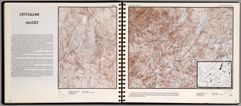
Author
[Scovel, James L., O'Brien, Emmett J]
Full Title
Crystalline Masses. Batholith. Rocky Bar, Idaho. (on opposite page) Rectangular Drainage. Elizabethtown, N.Y. Scale 1:62,500.(inset) Resulting in a rectangular drainage pattern.
List No
0889.030
Note
Contour map, with text, and location map. Relief shown by contours and spot height.
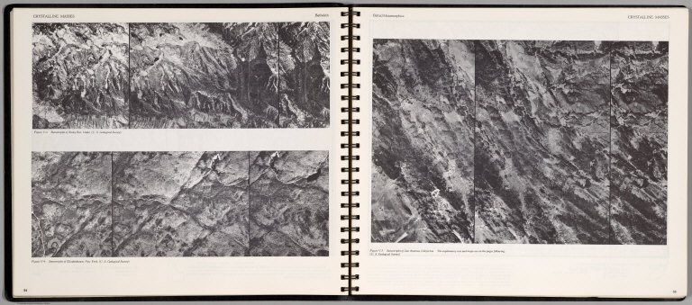
Author
[Scovel, James L., O'Brien, Emmett J]
Full Title
Crystalline Masses. Batholith. Stereotriplet of Rocky Bar, Idaho ... Stereotriplet of Elizabethtown, New York ... (on opposite page) Belted Metamorphic. Stereotriplet of San Andreas, California ...
List No
0889.031
Note
Three stereotriplets.
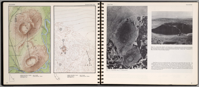
Author
[Scovel, James L., O'Brien, Emmett J]
Full Title
Vulcanism. Extrusive Cinder Cones. Menan Buttes, Idaho. Amboy Cratet, Calif. (on opposite page) Cinder Cones. (Views of) Manon Buttes, Idaho, and Amboy Crater, California.
List No
0889.035
Note
Two contour maps on one page. With location maps. Two views, and text on opposite page. Relief shown by contours and spot height.
Author
[Scovel, James L., O'Brien, Emmett J]
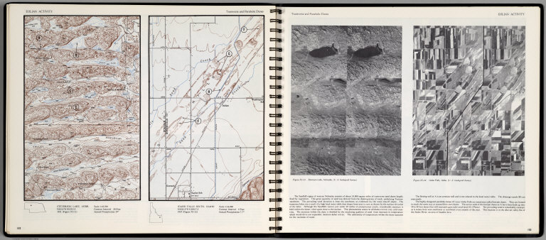
Full Title
Eolian Activity. Transverse and Parabolic Dunes. Steverson Lake, Nebr. Idaho Falls South, Idaho. Scale 1:24,000. (with aerial view on opposite page) Steverson Lake Nebraska, and Idaho Falls, Idaho.
List No
0889.080
Note
Contour color maps, with location map and text. Relief shown by contours and spot heights.
Author
[Thomas Bros., Thomas Brothers]
Full Title
Highway Map State of Idaho. (inset) City of Boise.
List No
0994.011
Author
Vandermaelen, Philippe, 1795-1869
Full Title
Partie de L'Oregon. Amer. Sep. 39... 1825
List No
10071.000
Note
This is an earlier variant edition of our 2212.244. Substantial changes to the topography. Hand col. lithographed map. Relief shown by hachures. Shows Indians tribes with populations, Lewis and Clarke's route, etc. Covers parts of Idaho, Montana and Wyoming.
Author
[Touring club italiano, Funk & Wagnalls Company.]
Full Title
(Legend to) Stati Uniti, United States of America, Washington, Oregon, Idaho. Propr. Artistico-letteraria del T.C.I. Ufficio cartografico del T.C.I. (1929)
List No
1012CR
Note
Explanation to map.
Author
[Touring club italiano, Funk & Wagnalls Company.]
Full Title
Stati Uniti, United States of America, Washington, Oregon, Idaho. Propr. Artistico-letteraria del T.C.I. Ufficio cartografico del T.C.I. (1929)
List No
1012.074
Note
Color map. Relief shown by hachures and spot heights; depths by isolines. Inset maps at 1:250,000 scale of the Seattle region and at 1:1,500,000 scale of the Puget Sound region.
Author
U.S. General Land Office
Full Title
(Map 15 - California, Nevada, Utah, Idaho).
List No
1071.017
Note
One of the series of adjacent sixteen maps. Mounted on linen. Relief shown in hachures.
Author
U.S. General Land Office
Full Title
(Map 16 - Washington, Oregon, Montana, Idaho).
List No
1071.018
Note
One of the series of adjacent sixteen maps. Mounted on linen. Relief shown in hachures.
Author
U.S. General Land Office
Full Title
Territory of Idaho. 1876. Compiled from the Official Records of the General Land Office and Other Sources by C. Roeser, PrincipaL Draughtsman, G.L.O. Photo Lith. & Print by Julius Bien, 16 & 18 Park Place N.Y.
List No
1074.000
Note
Mitchell copies this map in his1876 Atlas. From the 1876 Annual Report. in black and white. Shows township, railroad, county, & land district lines, and Indian reservations. Relief shown by hacures.
Author
U.S. General Land Office
Full Title
Department of the Interior, General Land Office. S.S. Burdett, Commissioner. Territory of Idaho. 1876. Compiled from the official records of the General Land Office and other sources by C. Roeser, Principal Draughtsman G.L.O. Photolith. & Print by Julius Bien 16 & 18 Park Place, N.Y.
List No
11179.004
Note
Color map. Includes references. Relief shown by hachures. Prime meridian is Greenwich.
Author
[Wallen, Henry Davies, 1819-1886, Dixon, Joseph H]
Full Title
Map Exhibiting The Routes between Fort Dalles And The Great Salt Lake. By Bvt. 2d Lieut. Joseph Dixon Topl. Engrs. From Explorations made by him while attached to the Wagon Road Expedition to the Valley of the Great Salt Lake under the command of Capt. H.D. Wallen 4th Infy. Compiled under the direction of Capt. Geo. Thom, Topl. Engrs. from the orders of Brig. Gen. W.S. Harney Commanding The Department Of Oregon. 1859. "Copy" Bureau of Topog. Engineers, November 9th 1860. Lith. of J. Bien, 180 Broadway N.Y.
List No
1144.000
Note
Large Dixon map showing Owyhee area; in case. With inset profile titled "Profile Of The Route From The Dalles To The Great Salt Lake City." Above the neat line reads "Sen. Ex. Doc. No. 1, 2nd Sess. 36th Cong." Map is without color. Relief shown by hachures.
Author
Rand McNally & Company
Full Title
Pictorial Map Idaho - Montana - Wyoming. Waterton-Glacier International Peace Park. Yellowstone National Park.
List No
12008.001
Note
Date estimated based on population note.
Author
Rand McNally & Company
Full Title
Idaho - Montana - Wyoming.
List No
12008.002
Note
Date estimated based on population note. Includes a western states mileage chart and a western states radio guide.
|