|
REFINE
Browse All : Images of Greenland and Canada
1-37 of 37
Author
Colton, G.W.
Full Title
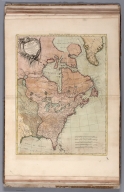
Northern America. British, Russian & Danish Possessions In North America. Published by J.H. Colton And Co. 172 William St. New York. Entered ... 1855 by J.H. Colton & Co. ... New York. No. 3.
List No
0149.012
Note
In full color.
Author
Malte-Brun, Conrad, 1775-1826
Full Title
Amerique Russe, Nouvelle Bretagne et Canada, 1836. No. 63. Grave par Thierry.
List No
0458.061
Note
Engraved map. Countries trimmed in color. Rivers, lakes, and islands shown. Major relief shown by hachures. Includes 3 scales.
Author
Polish Army Topography Service
Full Title
Canada - East. (inset) Quebec. (inset) Ottawa. Pergamon World Atlas. Pergamon Press, Ltd. & P.W.N. Poland 1967. Sluzba Topograficzna W.P.
List No
0737.189
Note
Detailed physical and political map.
Author
Society for the Diffusion of Useful Knowledge (Great Britain)
Full Title
British North America. Published under the superintendence of the Society for the Diffusion of Useful Knowledge. Engraved by J. & C. Walker. Published Decr. 1st. 1834 by Baldwin & Cradock, 47 Paternoster Row, London. (London: Chapman & Hall, 1844)
List No
0890.126
Note
Engraved map. Relief shown by hachures. Boundaries hand col.
Author
Thomson, John
Full Title
A chart of the discoveries of Captains Ross, Parry & Franklin in the Arctic Regions in the years 1818, 1819, 1820, 1821 & 1822. (with) Capt. Franklin's journey from Coppermine River to the head of Bathurst Inlet & return by Hood's River. J. Aspin delt. Hewitt sc., Buckingham Place. (Drawn & engraved for Thomson's New general atlas) (1822?)
List No
1007.082
Note
Engraved map with inset. Hand colored. David Rumsey Collection copy has the names "Mag. Pole" and "C. Garry" added in pencil. An added sheet.
Author
[Touring club italiano, Funk & Wagnalls Company.]
Full Title
(Legend to) Canada, Alasca, Groenlandia, Canada, Alaska, Gronland. Propr. Artistico-letteraria del T.C.I. Ufficio cartografico del T.C.I. (1929)
List No
1012CL
Note
Explanation to map.
Author
[Touring club italiano, Funk & Wagnalls Company.]
Full Title
Canada, Alasca, Groenlandia, Canada, Alaska, Gronland. Propr. Artistico-letteraria del T.C.I. Ufficio cartografico del T.C.I. (1929)
List No
1012.067
Note
Color map. Relief shown by hachures and spot heights; depths by isolines. Includes inset map at 1:500,000 scale of Ottawa region.
Author
[Lattre, Jean, 1743 -1793, Bonne, Rigobert, 1727-1794]
Full Title
Partie de l'Amerique Septentrionale : qui comprend le Canada, la Louisiane, le Labrador, le Groenland, les Etats-Unis et la Floride &c. Par Mr. Bonne. 1776. (to accompany) Atlas Geographique contenant la Mappemonde et les quatre parties, avec les differents Etats, avec apprpbation & privilage du Roy MDCC.LXIII (1763).
List No
11335.042
Note
Engraved outlined hand color map. Includes place names, and descriptive notes. Relief shown pictorially. Sheets also numbered XXXIV.
Author
[Wytfliet, Corneille, Magini, Giovanni Antonio]
Full Title
Estotilandia et Laboratoris terra. (to accompany) Histoire universelle des Indes occidentales et orientales, et de la conversion des Indiens : divisee en trois parties par Cornille Wytfliet & Anthoine Magin & autres historiens. Premiere Partie. A Douay, Chez Francois Fabri, l'An 1611.
List No
11622.064
Note
Uncolored engraved double page map of northeastern Canada, Greeland, Iceland, Labrador and includes the mystical island of Frisland and Estotiland. Shows cities, towns, landmarks, rivers, forests and mountains. Relief shown pictorially. Includes decorative title cartouche.
Author
Goos, Pieter, 1616-1675
Full Title
Paskaert Zynde de Noordelijckste Zeekusten Van America.
List No
12179.038
Author
Marmocchi, Francesco C.
Full Title
33. Islanda Groenlandia e Mediterraneo Artico.
List No
12235.034
Author
[Meyer, Herrmann Julius, 1826-1909., Ravenstein, Ludwig]
Full Title
Karte von Britisch Nord-America, Alaska und Gronland. Gez. E.G. Revenstein in London. 1869. Bibliographischen Instituts zu Hildburghausen. (to accompany) Meyer's Hand-Atlas ... 1872.
List No
13324.114
Note
Outline hand colored map, with inset map: Sudl. theil von Britisch Columbia. Showing political and administrative boundaries, Canadian states, major cites, towns, roads, rivers and mountains. Relief shown by hachures. Includes legend.
Author
[3, Soviet Union. Glavnoe upravlenie geodezii i kartografii]
Full Title
Северная Канада и Гренландия = Severnaia Kanada i Grenlandiia. 218-219. Atlas Mira : 1954.
List No
13682.232
Note
Physical map of Northern Canada and Greenland. Relief shown by gradient tints and spot heights. Depths shown by gradient tints, isolines and soundings.
Author
[3, Soviet Union. Glavnoe upravlenie geodezii i kartografii]
Full Title
Канада = Kanada. 220. Atlas Mira : 1954.
List No
13682.233
Note
Political map of Canada, part of the United States and Greenland. Relief shown by shadings and spot heights. Depths shown by gradient tints, isolines and soundings.
Author
[Československá akademie věd., Klíma, Jan]
Full Title
Kanada, Aljaška, Gronsko. Československý vojenský atlas̊.
List No
13684.157
Note
Map covers Canada, Alaska and Greenland. Equidistant Kuzelov projection. Showing Political and administrative boundaries, capitals, regions, and major cities. Relief shown by gradient tints, hachures and spot heights. Depth shown by bathymetric tints, isolines and soundings. Prime meridian: Greenwich.
Author
Hossein
Full Title
(Outline map of Canada) .جغرافیای عمومی اطلسی = Atlas of general geography. Istanbul 1300 (1923).
List No
13686.025
Note
Outline color map of Canada, Greenland, Iceland, Alaska and the Great Lakes.
Author
Colton, G.W.
Full Title
Northern America. Published by G. W & C. B. Colton & Co., No. 182 William St. New York.
List No
1550.015
Note
Prime meridians are Greenwich and Washington D.C.
Author
USSR (Union of Soviet Socialist Republics).
Full Title
(Map Title Page) 185-186. North Canada, Greenland. 187. Canada, Political.
List No
1603.196
Author
USSR (Union of Soviet Socialist Republics).
Full Title
185-186. North Canada and Greenland. The World Atlas.
List No
1603.197
Author
[White, James, Canada. Department of Interior]
Full Title
Department of Interior : Atlas of Canada, No. 29 : Aborigines of Canada, Alaska and Greenland. (to accompany) Department of the Interior, Canada ... 1906.
List No
1645.045
Note
Color map. With color coded legend. Shows major railway systems.
Author
[Canada. Department of Interior, Chalifour, J.E.]
Full Title
Aborigines of Canada, Alaska and Greenland. (on upper margin) Aborigines. Atlas of Canada. (to accompany) Department of the Interior Canada. Atlas Of Canada, 1915.
List No
1646.041
Note
Color map. Shows major cities, rivers, railways, etc. Indian tribes indicated by colors.
Author
Debenham, Frank
Full Title
Canada,Alaska, and Greenland. (copyright) G.P. Ltd.
List No
1794.017
Note
Relief map and text. Relief shown by gradient tints.
Author
[Fullback Academy, Peterson, Augusts]
Full Title
Greenland and Labrador. (Moravia Church establishments). Lithe. by A. Peterson, 9, Charing Cross. (1853)
List No
1868.005
Note
Color lithographed map. Shows Moravia stations with founding dates.
Author
Fullback Academy
Full Title
(Greenland), Labrador (compiled from the most recent and authentic sources, by the teachers of the Fullback Academy, 1853)
List No
1868K
Note
Continuation.
Author
[Instituto Geographico di Agostini, Bayer, Herbert]
Full Title
Canada, Alasca, Groenlandia. (insets) Toronto, Ottawa, Montreal, and Aleutine Occident.
List No
2170.091
Note
Relief shown as combined hachures and hypsometric tints; bathymetry also tinted.
Author
[Lowry, J.W., Sharpe, J.]
Full Title
Sharpe's Corresponding Maps. British North America. London - Published by Chapman and Hall, 186 Strand, 1848. Continental Series.
List No
2175.044
Note
Relief shown by hachures. Countries and provinces outlined in color.
Author
Colton, G.W.
Full Title
British, Russian & Danish Possessions in North America.
List No
2441.023
Author
Bonne, Rigobert, 1727-1794
Full Title
Partie de l'Amerique Septentrionale, qui comprend le Canada, la Louisiane, le Labrador, le Groenland, les Etats-Unis et la Floride. (1ere. feuille). Projettee et assujettie aux observations. Par Mr. Bonne. A Paris, chez Lattre, rue St. Jacques, a la Ville de Bordeaux. Avec priv. du Roy. Revue et corrigee 1783.
List No
2612.071
Note
Engraved map. Sheet 1 (north) of 2 sheets. Boundaries outlined in hand col. Relief shown pictorially. Ornamental cartouche. Prime meridian: Ferro. "XXXIV."
Author
Carey, Mathew
Full Title
The British Possessions in North America From the latest Authorities 1814. W. Robinson Sc.
List No
2721.009
Note
An outline color map centered around Hudsons Bay. Prime meridian Washington D.C. Relief shown by sketches.
Author
Lange, Henry, 1821-1893.
Full Title
Britisches Nord Amerika. H. Lange's Atlas v. Nord Amerika Blatt XIV. Braunschweig: Verlag v. George Westermann. Lith. Anst. von L. Kraatz in Berlin.
List No
2743.014
Note
Engraved map. Borders hand col. Shows meteorological stations, administrative divisions, northern limit of forests, etc. Relief shown by hachures. Covers also part of Greenland.
Author
Melish, John
Full Title
A General Chart Showing the Track and Discoveries of H.M. Ships Isabella & Alexander to Davis's Straits & Baffin Islands Bay in an Attempt to Discover a Passage into the Pacific Ocean. Commanded by Capn. Ross R.N. Drawn under his Inspection by J. Bushman, Midn. R.N. (1824)
List No
2803.017
Note
Engraved. Meridian Greenwich. Shows position of the sea ice.
Author
Carey, Mathew
Full Title
The British Possessions in North America From the latest Authorities 1814. W. Robinson Sc.
List No
4577.004
Note
An outline color map centered around Hudsons Bay.
Author
[Marzolla, Benedetto, Society for the Diffusion of Useful Knowledge (Great Britain)]
Full Title
America Settentrionale Inglese e Russa, Groenlandia, Islanda, Terre Artiche col passaggio Nord-Ovest, soverto dalla nave l'Investigatore sotto il comando del Capitano Mac-Clure nel 1853. La presente Carta e stata eseguita su quella, pubblicata in Londra nel 1834, dalla Societa per la diffuzione delle utili conoscenze ... Essa fa parte dell'Atlante Geografico che si pubblica da B. Marzolla. Napoli 1854.
List No
4714.038
Note
Lithographed map. Borders hand col. Relief shown by hachures. Includes notes.
Author
Colton, G.W.
Full Title
Northern America, British, Russian & Danish Possessions in North America. No. 3. Published by J.H. Colton & Co., No 172 William St., New York.
List No
5479.006
Note
Meridians Washington and Greenwich. States tinted in color. Relief shown in hachures.
Author
Hayes, Isaac Israel
Full Title
Baffin Bay, illustrating an Arctic boat journey in 1854. I.I. Hayes. (1855?)
List No
5722.000
Note
Black and red pen-and-ink on tracing paper. Shows routes of Dr. Hayes, Dr. Kane (1855), prevailing direction of ocean currents, etc. Includes inset. Laid in: Atlas encyclopedique ... 1827 (our no. 1801)
Author
[Bayer, Herbert, Container Corporation of America]
Full Title
Canada. Alaska and Greenland. (insets) (Vicinity of Toronto, Ottawa, and Montreal).
List No
5842.090
Note
Relief depicted by hachures and hypsometric tints.
Author
[Sanson, Nicolas, 1600-1667, Sanson, Guillaume (1633-1703)]
Full Title
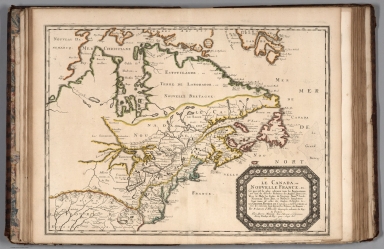
Le Canada ou Nouvelle France. (Canada or New France.)
List No
9741.136
1-37 of 37
|