|
Author
Bolitho, Edwin
Full Title
Map of the Dahlonega Distrtict, GA. (to accompany) Pocket Mining Atlas. Compiled From The Latest Official Surveys, And The Most Authentic Sources. Edwin Bolitho, Engineering and Mining Journal, New York, 1880. Price, $1.00 per copy. (on following page) Entered ... 1880 ... Washington, D.C., by Trask & Francis, Bankers ... 70 Broadway, New York ...
List No
3054.006
Note
Full color map. Showing districts and counties.
Author
Leahy, J.F.
Full Title
(Index Page to) Leahy's Hotel Guide and Railway Distance Maps. Georgia.
List No
0425.024
Note
Alphabetical index list of the Hotels of the town with the number of rooms of each, their rates per day and the population of the town. Includes population of the state.
Author
Leahy, J.F.
Full Title
Leahy's Hotel Guide and Railway Distance Map of the State of Georgia. Published by American Hotel Register Company. Leahy Build., 228-234 W. Ontario St., Chicago, Ill. Copyrighted by J.F. Leahy, Jan., 1934.
List No
0425.025
Note
Map printed without color. Includes name of the railroad entering the town, and distance between towns. With Explanation of abbreviation of the railroad of the state.
Author
Finley, Anthony
Full Title
Map Of North and South Carolina And Georgia, Constructed from the Latest Authorities. 1825. Copyright secured. J.H. Young Sculp. Published by A. Finley Philada. 1824.
List No
0278.008
Note
In full color by county. Topographical table includes population by state from the 1820 census for "White, Free Black & Slave Population".
Author
W. & A.K. Johnston Limited
Full Title
Virginia, West Virginia, Maryland, Delaware. North Carolina, South Carolina, Georgia.
List No
6921.122
Author
Tanner, Henry S.
Full Title
Georgia and Alabama By H.S. Tanner. Published by H.S. Tanner, Philadelphia. Engraved by H.S. Tanner & Assistants. Entered ... 20th day of August 1823, by H.S. Tanner... Pennsylvania. American Atlas.
List No
2589.034
Note
In full color by county. Trimmed close at bottom of map.
Author
Tanner, Henry S.
Full Title
Georgia and Alabama By H.S. Tanner. Published by H.S. Tanner, Philadelphia. Engraved by H.S. Tanner & Assistants. Entered ... 20th day of August 1823, by H.S. Tanner... Pennsylvania. American Atlas.
List No
5022.029
Note
In full color by county.
Author
Tanner, Henry S.
Full Title
Georgia and Alabama By H.S. Tanner. Improved to 1825. Published by H.S. Tanner, Philadelphia. Engraved by H.S. Tanner & Assistants. Entered ... 20th day of August 1823, by H.S. Tanner... Pennsylvania. American Atlas.
List No
2593.031
Note
In full color by county.
Author
Bellin, Jacques Nicolas, 1703-1772
Full Title
Carte de la Nouvelle Georgie.
List No
6903.046
Note
uncolored map. Showing rivers, canals, ports, etc.
Author
Bellin, Jacques Nicolas, 1703-1772
Full Title
Carte De L'Armenie, Georgie et Pays Voisins.
List No
6903.226
Note
Decorative title cartouche. Relief shown pictorially. Shows settlements, rivers, etc.
Author
[Gray, Ormando Willis, Lloyd, H.H., Walling, H. F.]
Full Title
Atlas of the United States. Florida, Georgia, and South Carolina. (Published by Stedman, Brown & Lyon, Cincinnati. 1872. Entered ... 1872, by H.F. Walling, and O.W. Gray, and H.H. Lloyd & Co. ... Washington)
List No
2710.035
Note
Hand col. lithographed map. Counties in full color.
Author
Mitchell, Samuel Augustus Jr.
Full Title
County map of Georgia, and Alabama. Entered ... 1860 by S. Augustus Mitchell, Jr. ... Pennsylvania.
List No
0572.026
Note
Full color map by county. Prime meridians are Greenwich and Washington, D.C.
Author
Mitchell, Samuel Augustus Jr.
Full Title
County map of North Carolina. (Scale: 1:2,800,000). Map of South Carolina. (Scale: 1:2,550,000). (inset) 31. Map of Charleston Harbor. County map of Florida. (Scale:1:3,700,000). Entered ... 1860 by S. Augustus Mitchell, Jr. ... Pennsylvania.
List No
0572.027
Note
Three color maps on one page. Relief shown by hachures. Prime meridians are Greenwich and Washington, D.C.
Author
Carey, Mathew
Full Title
Georgia from the latest Authorities. W. Barker, sculp. Engraved for Carey's American Edition of Guthrie's Geography improved.
List No
2931.040
Note
Uncolored.
Author
[Bowen, Emanuel, Gibson, John]
Full Title
Carolina And Georgia. (to accompany) Atlas Minimus or a New Set of Pocket Maps of the Several Empires, Kingdoms and States of the Known World, with Historical Extracts relative to each. Drawn and Engraved by J. Gibson from the Best Authorities, Revis'd, Corrected and Improv'd by Eman: Bowen Geographer to His Majesty.
List No
0300.048
Note
First edition. The "Historical Extracts" are short bits of text printed on the maps giving relevant geographical information. A revised edition was published in London in 1792. In 1759, another edition was published adding separate geographical descriptions and correcting some of the maps (see our copy). The Philadelphia 1798 edition by Mathew Carey incorporates the 1759 edition text word for word (excepting the maps of United States which Carey omits in favor of his pocket atlas of the U.S.). Gibson and Bowen made the four sheet map of North America (Stevens 49), and Gibson made the four sheet map of America (Stevens 3).
Author
Carey, Mathew
Full Title
Georgia from the latest Authorities. W. Barker, sculp. Engraved for Carey's American Edition of Guthrie's Geography improved.
List No
2862.039
Note
Uncolored.
Author
[Andree, Richard, Scobel, Albert]
Full Title
Kaukasuslader. Sept. 1905.
List No
1463.076
Note
Outline color map. Shows settlements, inhabitants, telegraph cables, railways, canals, etc. Includes note. Shows Caucasus Mountain Region. Relief shown by hachures and spot heights. Depth shown by bathymetric tints and soundings. Prime meridian is Greenwich.
Author
Tanner, Henry S.
Full Title
Georgia and Alabama. (engraved by) J. Knight. Sc. (to accompany) A New Pocket Atlas of the United States With The Roads and Distances, Designed For the Use of Travelers. By H.S. Tanner. Philadelphia: Published by the Author. 1828. (on verso) ...on the seventeenth day of November ... 1828, Henry S. Tanner ... hath deposited ... a book ... Pennsylvania.
List No
2782.012
Note
Outline colored map. Prime meridian is Washington, D.C. Rare. Same maps used in Darby's View of U.S. Although this appears in Tanner's catalogues for several years after 1828, it must not have sold well, as few copies have survived. Bound with half leather and paper covered boards. "Pocket Atlas" embossed on spine.
Author
Vandermaelen, Philippe, 1795-1869
Full Title
Partie de la Russie d'Europe. Europe no. 23. (Dresse par Ph. Vandermaelen, lithographie par H. Ode. Premier partie. - Europe. Bruxelles. 1827)
List No
2212.027
Note
Hand col. lithographed map. Relief shown by hachures. Covers parts of Russia and Georgia. Prime meridian: Paris.
Author
Johnson, A.J.
Full Title
Johnson's Georgia And Alabama By Johnson & Browning. No. 28-29.
List No
2905.018
Note
In full color by county.
Author
Mitchell, Samuel Augustus Jr.
Full Title
County map of the States of Georgia and Alabama. Entered ... 1874, by S. Augustus Mitchell ... Washington. (with inset maps) Savannah, Georgia. City of Atlanta, the capital of Georgia.
List No
3804.026
Note
Hand colored map. Shows settlements, railroads, rivers, etc. Prime meridians are Greenwich and Washington.
Author
Mitchell, Samuel Augustus
Full Title
A New Map of Georgia.
List No
4835.029
Author
Delamarche, Felix.
Full Title
Carte de L'Asie Mineure ... 1845.
List No
4758.014
Author
[Raynal, G.T., Bonne, R.]
Full Title
Carte de la Perse, de la Georgie, et de la Tartarie Independante. Par M. Bonne, Ingenieur, Hdrographe de la Marine. (on upper margin) Liv. III, IV et V.: No. 18. (on lower margin) 19. (to accompany) Histoire Philosophique et Politique Des Establissements et Du Commerce Des Europeens Dans Les Deux Indes.
List No
3083.034
Note
Uncolored copper engraving map. Relief shown pictorially. Prime meridians are Ferro and Paris.
Author
[Raynal, G.T., Bonne, R.]
Full Title
Carte de la partie sud des Etats Unis de l'Amerique septentrionale. Par M. Bonne, Ingenieur-Hydrographe de la Marine. (Grave par) Dien. (on upper margin) Liv. XVII, XVIII. : No. 48. (on lower margin) 49. (to accompany) Histoire Philosophique et Politique Des Establissements et Du Commerce Des Europeens Dans Les Deux Indes.
List No
3083.064
Note
Detailed map, uncolored copper engraving. Relief shown by pictorially. Prime meridians are Ferro and Paris.
Author
Mitchell, Samuel Augustus Jr.
Full Title
County map of the States of Georgia and Alabama. Entered ... 1876 by S. Augustus Mitchell, . ... Washington. (inset maps): Savannah Georgia. (with reference to squares), and City of Atlanta, the capital of Georgia.
List No
4564.027
Note
Full color map by county. Shows settlements, roads, railroads, rivers, etc. Prime meridians are Greenwich and Washington.
Author
Mitchell, Samuel Augustus
Full Title
A New Map of Georgia. With its Roads & Distances. Published by Charles Desilver, No. 251 Market Street Philadelphia. Entered ... 1856 by Charles Desilver ... Pennsylvania.
List No
2514.022
Note
Full color map. Shows state capital, towns, railroads, canals, etc. With table of steam boat routes. Relief shown by hachures. Prime meridian is Washington.
Author
[Rand McNally and Company, State Farm Insurance Companies Travel Bureau]
Full Title
Rand McNally Road map: Georgia. Copyright by Rand McNally & Company, Chicago, Ill. Lithorgaphed in the U.S.A. U.3620. (to accompany) State Farm road atlas : United States, Canada, Mexico.
List No
6825.024
Note
Color map. U.S. interstate highways shown in red. Shows time zone boundaries, roads, ferries, highways, rivers and streams. Includes population of cities and towns. Relief shown by hachures.
Author
National Map Company
Full Title
Georgia. (Copyrighted by) National Map Company, Indianapolis. (to accompany) Official Paved Road and Commercial Survey of the United States.
List No
4048.032
Note
Outline color map. Shows administrative divisions, roads, rivers, etc. Prime meridian is Greenwich.
Author
Tanner, Henry S.
Full Title
Georgia And Alabama By H.S. Tanner. Improved To 1825. American Atlas. Entered ... 20th day of August 1823, by H.S. Tanner ... Pennsylvania. Published by H.S. Tanner, Philadelphia. Engraved by H.S. Tanner & Assistants.
List No
2755.015
Note
In full color by county.
Author
Appleton, D. & Co.
Full Title
Map of Georgia. Copyright 1891 by Matthews-Northrup Co. ... Buffalo, New York. (inset) Map of Atlanta. (to accompany) The Library Atlas Of Modern Geography ... New York, D. Appleton And Company 1892. (on upper margin) Georgia. 60.
List No
0026.155
Note
Color map. Shows county boundaries and county seat, capital, railways, roads, etc. "Size of type indicates importance of the places". Includes notes. Relief shown by hachures. Prime meridians are Greenwich and Washington.
Author
[Johnston, Alexander Keith, 1804-1871, Rogers, Henry Darwin]
Full Title
States Of South Carolina, Georgia, Alabama, And Florida. By Prof. H.D. Rogers & A. Keith Johnston, F.R.S.E. Entered in Sta. Hall. London ... & according to an act of Congress ... 1857, by H.D. Rogers ... Massachusetts. London, John Murray, Albemarle Street, Edinburgh, W. & A.K. Johnston. Engraved by W. & A.K. Johnston, Edinburgh.
List No
3825.016
Note
States and counties shown in outline printed color. Bahamas shown off the Florida coast.
Author
Gray, O.W.
Full Title
Gray's Atlas Map of Georgia.
List No
0310.051
Author
Bradford, Thomas G.
Full Title
North Carolina, South Carolina and Georgia. (to accompany) A Comprehensive Atlas, Geographical, Historical & Commercial. By T.G. Bradford. Boston: American Stationers' Company. Entered ... 1835, by Thos. G. Bradford ... Massachusetts.
List No
2120.041
Note
Color map. Shows administrative boundaries, cities and towns, roads, railroads, rivers, canals, mountains, etc. Includes explanation. Relief shown by hachures. Prime meridians are Washington and Greenwich.
Author
Bradford, Thomas G.
Full Title
Georgia. (to accompany) A Comprehensive Atlas, Geographical, Historical & Commercial. By T.G. Bradford. Boston: American Stationers' Company. Entered ... 1835, by Thos. G. Bradford ... Massachusetts.
List No
2120.042
Note
Color map. Shows administrative boundaries, county, cities and towns, roads, railroads, rivers, canals, mountains, etc. Includes explanation. Relief shown by hachures. Prime meridians are Washington and Greenwich.
Author
Bradford, Thomas G.
Full Title
(Text Page to) Georgia. South Carolina). (to accompany) A Comprehensive Atlas, Geographical, Historical & Commercial. By T.G. Bradford. Boston: American Stationers' Company. Entered ... 1835, by Thos. G. Bradford ... Massachusetts.
List No
2120.043
Note
Text to the General map of South Carolina and Georgia. Includes population products, history, etc.
Author
Bradford, Thomas G.
Full Title
North Carolina, South Carolina and Georgia. (to accompany) A Comprehensive Atlas, Geographical, Historical & Commercial. By T.G. Bradford. William D. Ticknor, Boston. Wiley & Long, New-York. Entered ... 1835, by Thos. G. Bradford ... Massachusetts.
List No
2643.041
Note
Outline color map by administrative boundaries. Shows cities and towns, roads, railroads, rivers, canals, mountains, etc. Includes explanation. Relief shown by hachures. Prime meridians are Washington and Greenwich.
Author
Bradford, Thomas G.
Full Title
Georgia. (to accompany) A Comprehensive Atlas, Geographical, Historical & Commercial. By T.G. Bradford. William D. Ticknor, Boston. Wiley & Long, New-York. Entered ... 1835, by Thos. G. Bradford ... Massachusetts.
List No
2643.042
Note
Outline color map by administrative boundaries. Shows cities and towns, canals, roads, rivers, mountains, etc. Includes explanation. Relief shown pictorially. Prime meridians are Washington and Greenwich.
Author
Finley, Anthony
Full Title
Map of North and South Carolina and Georgia, Constructed from the Latest Authorities, 1827.
List No
0279.012
Author
[Gray, Frank A., Gray, O.W.]
Full Title
Gray's New Map of Georgia by Frank A. Gray. Copyright 1877 by O.W. Gray & Son. (insets) Entrance to Savannah River. Savannah.
List No
0312.026
Author
Cram, George Franklin
Full Title
Cram's Rail Road & Township Map of Georgia.
List No
4533.019
Author
Tanner, Henry S.
Full Title
A New Map of Georgia with Its Canals, Roads & Distances by H.S. Tanner.
List No
0976.022
Author
Tanner, Henry S.
Full Title
A New Map of Georgia.
List No
7858.029
Author
[Morse, Sidney E. (Sidney Edwards), 1794-1871, Breese, S.]
Full Title
Georgia. Entered ... 1842, by Sidney E. Morse and Samuel Breese ... New-York. (to accompany) Supplement To The New-York Observer. The Cerographic Atlas Of The United States. By Sidney E. Morse, A.M. And Samuel Breese, A.M. New-York: Published By Sidney E. Morse & Co. 1843.
List No
4180.017
Note
Uncolored map. Shows state capital, county, towns, roads, railroads, rivers, canals, etc. Relief shown by hachures. Prime meridian is Washington. Includes explanation.
Author
Tanner, Henry S.
Full Title
A New Map of Georgia with Its Canals, Roads & Distances by H.S. Tanner.
List No
0980.022
Author
Mitchell, Samuel Augustus
Full Title
A New Map of the State of Georgia Exhibiting Its Internal Improvements, Roads, Distances &c. By J.H. Young. Philadelphia, Published By Charles Desilver, No. 714 Chestnut St. 20. Entered ... 1859, by Charles Desilver ... Pennsylvania. (to accompany) A New Universal Atlas Containing Maps of the various Empires, Kingdoms, States and Republics Of The World.
List No
8065.022
Note
Colored by county. Prime Meridian is Washington. Relief shown by hachures. Shows capital, railroads, roads, major cities and towns.
Author
[Morse, Sidney E. (Sidney Edwards), 1794-1871, Breese, Samuel]
Full Title
Georgia. Entered ... 1842, by Sidney E. Morse and Samuel Breese ... New York. (New York: Published by Harper & Brothers, 1845). (to accompany) Morse's Cerographic Maps. No. VII.
List No
4861.057
Note
Color wax engraved map. Shows capital, towns, road, railroads, rivers, canals, etc. Includes explanation. Relief shown by hachures. Prime meridians are Greenwich and Washington.
Author
Bradstreet Company
Full Title
Georgia. (to accompany) Bradstreet's Pocket Atlas Of The United States. Published Exclusively for Macullar, Parker & Company, Boston, Massachusetts ... New York: The Bradstreet Company, 1885. (on verso) Entered ... 1879, by The Bradstreet Company ... Washington.
List No
2054.030
Note
Full color map. Relief shown by hachures. Prime meridian is Washington, D.C.
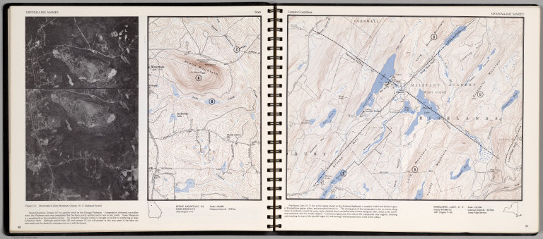
Author
[Scovel, James L., O'Brien, Emmett J]
Full Title
Crystalline Masses. Stock. Stone Mountain, GA. (inset) Stereotriplet of Stone Mountain, Georgia. (on opposite page) Complex Crystallines. Popolopen Lake, N.Y. Scale 1:25,000.
List No
0889.033
Note
Two contour maps on two pages, with text, and location map. Relief shown by contours and spot height.
Author
Mitchell, Samuel Augustus
Full Title
A New Map of the State of Georgia Exhibiting Its Internal Improvements, Roads, Distances &c. By J.H. Young. Philadelphia, Published By Charles Desilver, No. 714 Chesnut Street. Entered according to Act of Congress in the year 1860 by Charles Desilver in the Clerk's office if the District Court of the Eastern District of Pennsylvania. 20.
List No
6727.022
Note
Counties tinted in color. Meridians Washington and Greenwich. Relief shown in hachures.
|