|
Author
[Weekly Dispatch, Weller, Edward, 1819-1884]
Full Title
The Caucasus (Circassia, Georgia &c) and Armenia / by Edwd. Weller F. R. G. S. ; engraved by Edwd. Weller, Duke Street, Bloomsbury ; E. Weller Lithogr.
List No
14360.159
Note
Map of Caucasus (including Circassia and Georgia) and Armenia. Shows political boundaries, cities, railways, roads, canals, topography, bodies of water, drainage, coastlines and islands. Relief shown with hachures. Includes latitudinal and longitudinal lines, as well as three bar scales given in geographical and British miles and Russian versts. Hand-colored lithograph. Map is 32 x 42 cm, on sheet 33 x 48 cm. Plate number handwritten in ink at upper left corner of sheet; "9/10/59" in pencil at bottom of sheet. Appears in Vol. II : Foreign.
Author
شكوفه مقبل [Şukufe Mukbil]
Full Title
(The Caucasus with railroads)
List No
10992.021
Note
Dimensions are sheet size.
Author
Rand McNally and Company
Full Title
Rand McNally junior auto road map Georgia. Copyright by Rand McNally & Co., Chicago, Ill. (1927)
List No
5755.011
Note
Color map. Relief shown by hachures. Shows settlements, classified roads with distances, etc. "I-13."
Author
Rand McNally and Company
Full Title
Atlanta and vicinity. Jacksonville and vicinity. Memphis and vicinity. Cleveland and vicinity. Copyright by Rand McNally & Co., Chicago, Ill. (1927)
List No
5755.046
Note
Four maps on facing pages. In blue ink. Relief shown by hachures. Show settlements, classified roads with distances, etc.
Author
[Berghaus, Heinrich, 1797-1884, Sohr, Karl, Flemming, Carl]
Full Title
Generalkarte vom Kaukasus. Entw. u. gez. v. F. Handtke. Druck und Verlag von C. Flemming in Glogau. (to accompany) Vollstandiger Universal-Handatlas der neueren Erdbeschreibung ,,, Heinrich Berghaus ... 1859.
List No
13250.091
Note
1 map on 2 sheets. Hand colored in outline. In upper margin: Kaukasus No. I. Relief shown by hachures. Includes explanation and administrative table.
Author
[Berghaus, Heinrich, 1797-1884, Sohr, Karl, Flemming, Carl]
Full Title
Generalkarte vom Kaukasus. Entw. u. gez. v. F. Handtke. Druck und Verlag von C. Flemming in Glogau. (to accompany) Vollstandiger Universal-Handatlas der neueren Erdbeschreibung ,,, Heinrich Berghaus ... 1859.
List No
13250.092
Note
1 map on 2 sheets. Hand colored in outline. In upper margin: Kaukasus No. II. Relief shown by hachures. Includes explanation and administrative table.
Author
[Berghaus, Heinrich, 1797-1884, Sohr, Karl, Flemming, Carl]
Full Title
(Composite Map) Generalkarte vom Kaukasus. Entw. u. gez. v. F. Handtke. Druck und Verlag von C. Flemming in Glogau. (to accompany) Vollstandiger Universal-Handatlas der neueren Erdbeschreibung ,,, Heinrich Berghaus ... 1859.
List No
13250.093
Note
Composite map of Kaukasus, Sheets I-II.
Author
United States. Post Office Department
Full Title
Post Route Map of the State of Georgia Showing Post Offices with the Intermediate Distances on Mail Route ... November 2, 1959.
List No
9224.000
Full Title
Georgia. (Published by George F. Cram, Chicago, Ill. 1909)
List No
2134.072
Note
Map in full color. Shows counties, settlements, railroads, etc. Includes index to counties.
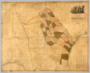
Author
Burr, David H., 1803-1875
Full Title
Georgia. Entered ... 1834, by Thos. Illman ... New York.
List No
4628.052
Note
In full color by county.
Author
Bache, A. D.
Full Title
Savannah River. Reconnaissance of the approaches to the city of Savannah including Front & Back Rivers. U.S. Coast Survey. A.D. Bache, Superintendent. By the hydrographic party under the command of Lieut. J.N. Maffitt, U.S.N. & asst. U.S.C.S. 1851. (with logo) U.S. Coast Survey Office.
List No
2470.036
Note
Engraved nautical chart. Depths shown by soundings. Includes descriptive notes. In upper margin "Presented under authority of an act of Congress of the United States of June 3d 1844 by direction of the Treasury Department, A.D. Bache Superintendent Coast Survey."
Author
[Cram, George Franklin, Murray-Aaron, Eugene, 1852-1941.]
Full Title
Map of Georgia. Published by George F. Cram, Chicago, Ill. (to accompany) Cram's atlas of the world, ancient and modern : new census edition -- indexed.
List No
1910.046
Note
In full color on 2 pages. Shows administrative divisions, cities and towns, railroads, roads, rivers, etc. Prime meridian is Greenwich.
Full Title
(Map of Alabama, Georgia and part of Florida. Raleigh: Branson, Farrar & Co., Publishers. Biblical Recorder Print. 1863)
List No
2915.004
Note
Black and white map. Shows state boundaries, settlements, railroads, etc.
Author
Heck, Johann Georg, 1795 -1857
Full Title
14. Aste Mineure Ancienne, l'Armenie, la Syrie, la Mesopotemie &.
List No
12128.017
Author
[Emory University, Wrigley]
Full Title
Atlanta campus : Emory University 1940-1941. Wrigley's.
List No
11342.000
Note
Colored pictorial map of the University of Emory campus. Covered with buildings and facilities. Shows various games in progress. Shows roads, railroads and wooded areas. Includes decorative title carthouche and compass rose.
Author
[Chatelain Henri, 1684-1743, Gueudeville, Nicolas]
Full Title
Vue et description des principales villes de l'Armenie et de la Georgie. Tom. V. No. 11. Pag. 28. (to accompany) Atlas Historique ... Tom. V. A Amsterdam, chez L'Honore & Chatelain Libraires. M DCC XIX (1719).
List No
13272.466
Note
Engraved folded plate of views and description of the major cities of Armenia and Georgia, with the costumes of women and Priests and religious figures of the region.
Author
Gannett, Henry, 1846-1914
Full Title
Sketch map showing the position of the center of the Negro population and the median point in 1880, 1890 and 1900. Compiled by Henry Gannett, Geographer. (United States Census Office, 1903). Julius Bien & Co., N.Y.
List No
2152.052
Note
Lithographed map. Covers parts of Alabama, Georgia and Tennessee. Also shows counties, cities, railroads, etc.
Author
United States. Post Office Department
Full Title
Post Route Map of the State of Georgia Showing Post Offices with the Intermediate Distances on Mail Route ... November 2, 1959.
List No
9378.000
Author
Lewis, Samuel
Full Title
Georgia. Drawn by S. Lewis. D. Fairman sc. (Boston: Published by Thomas & Andrews. 1812)
List No
0028.045
Note
Engraved map, uncolored. Relief shown by hachures. Prime meridians: Philadelphia and London.
Author
Mitchell, Samuel Augustus.
Full Title
A new map of Georgia with its roads & distances. Published By S. Augustus Mitchell, N.E. corner of Market & 7th Streets. Philadelphia. Entered ... 1846, by H.N. Burroughs ... Pennsylvania. (to accompany) A New Universal Atlas Containing Maps of the various Empires, Kingdoms, States and Republics Of The World.
List No
3697.024
Note
Color copper lithograph map by county. Shows roads, railroads, capitals, canals, important towns, rivers and mountains. Includes explanation, notes and steamboat routes. Relief shown by hachures. Prime meridian is Washington.
Author
Lewis, Samuel
Full Title
Georgia. Drawn by S. Lewis. D. Fairman sc. (Published by John Conrad & Co., Philadelphia. 1804)
List No
2436.050
Note
Engraved map, uncolored. Relief shown by hachures. Prime meridians: Philadelphia and London.
Author
Scheda, Joseph Ritter (1815-1888)
Full Title
XX. (Georgia, Azerbaijan, Armenia, Iran).
List No
7927.022
Author
[Baranov, Anatolij Nikolaevič, Soviet Union. Glavnoe upravlenie geodezii i kartografii]
Full Title
Kavkaz. 46-47. Atlas Mira : 1954.
List No
13682.060
Note
Political and physical map of Caucasus. Showing political and regional boundaries, rivers, railways and roads. Relief shown by gradient tints, contours and spot heights. Depth shown by bathymetric tints, isolines and soundings.
Author
[Baranov, Anatolij Nikolaevič, Soviet Union. Glavnoe upravlenie geodezii i kartografii]
Full Title
Gruzinskaia SSR. 49. Atlas Mira : 1954.
List No
13682.062
Note
Detailed map of Georgia. Showing political and regional boundaries, rivers, railways and roads. Relief shown by shadings and spot heights.
Author
[3, Soviet Union. Glavnoe upravlenie geodezii i kartografii]
Full Title
Юго-Восток США = IUgo-Vostok Ssha. 236-237. Atlas Mira : 1954.
List No
13682.250
Note
Physical map of the Southeast of the United States. Showing state boundaries. Relief shown by shadings and spot heights. Depths shown by gradient tints, isolines and soundings.
Author
[Kellogg, Sanford Cobb, 1842-, Mergell, C. S., United States. Army. Corps of Engineers]
Full Title
The Chattanooga Campaign of August and September 1863, enlarged from a map compiled in 1865, by C.S. Mergell, under the direction of Col. W.E. Merrill, 1st U.S. V.V. Eng'rs, and published by the Chief of Engineers of the Army in 1874. Drawn by J. von Glumer. Positions of troops located in 1891 by Captain S.C. Kellogg, 5th Cavalry. Julius Bien & Co. lith. (Washington, D.C.: U.S. Government Printing Office, 1891)
List No
4249.004
Note
Col. lithographed map. Relief shown by hachures and spot heights. Includes lengthy note "Legend." Shows actions July 15-Aug. 31.
Author
[Kellogg, Sanford Cobb, 1842-, Mergell, C. S., United States. Army. Corps of Engineers]
Full Title
The Chattanooga Campaign of August and September 1863, enlarged from a map compiled in 1865, by C.S. Mergell, under the direction of Col. W.E. Merrill, 1st U.S. V.V. Eng'rs, and published by the Chief of Engineers of the Army in 1874. Drawn by J. von Glumer. Positions of troops located in 1891 by Captain S.C. Kellogg, 5th Cavalry. Julius Bien & Co. lith. (Washington, D.C.: U.S. Government Printing Office, 1891)
List No
4249.005
Note
Col. lithographed map. Relief shown by hachures and spot heights. Includes lengthy note "Legend." Shows actions Aug. 29-Sept. 17.
Author
[Kellogg, Sanford Cobb, 1842-, Mergell, C. S., United States. Army. Corps of Engineers]
Full Title
The Chattanooga Campaign of August and September 1863, enlarged from a map compiled in 1865, by C.S. Mergell, under the direction of Col. W.E. Merrill, 1st U.S. V.V. Eng'rs, and published by the Chief of Engineers of the Army in 1874. Drawn by J. von Glumer. Positions of troops located in 1891 by Captain S.C. Kellogg, 5th Cavalry. Julius Bien & Co. lith. (Washington, D.C.: U.S. Government Printing Office, 1891)
List No
4249.006
Note
Col. lithographed map. Relief shown by hachures and spot heights. Includes lengthy note "Legend." Shows actions Sept. 9-19.
Author
[Kellogg, Sanford Cobb, 1842-, Mergell, C. S., United States. Army. Corps of Engineers]
Full Title
The Chattanooga Campaign of August and September 1863, enlarged from a map compiled in 1865, by C.S. Mergell, under the direction of Col. W.E. Merrill, 1st U.S. V.V. Eng'rs, and published by the Chief of Engineers of the Army in 1874. Drawn by J. von Glumer. Positions of troops located in 1891 by Captain S.C. Kellogg, 5th Cavalry. Movements and positions preceding Battle of Chickamauga, locations made by Captain S.C. Kellogg, 5th Cavalry, 1891. Julius Bien & Co. lith. (Washington, D.C.: U.S. Government Printing Office, 1891)
List No
4249.007
Note
Two col. lithographed maps on 1 sheet. Scale of "Movements and positions preceding Battle of Chickamauga ..." (ca. 1:82,000), covering W 85o 20'--W 85o05'/N 35o10'--N 34o40'). Relief shown by hachures and spot heights. Includes lengthy note "Legend." In margin: Errata * In last line of legend for westward read eastward. Shows actions July 10-Sept. 13.
Author
Fullarton, A. & Co.
Full Title
United States North America According to Calvin, Smith & Tanner. By G.H. Swanston Edinr. The South Eastern States Comprising Mississippi, Alabama, Tennessee, Georgia, Nth. & Sth. Carolina, and part of Florida, Virginia & Kentucky. LVIII. Engd. by G.H. Swanston Edinburgh. A. Fullarton & Co. Edinburgh, London & Dublin.
List No
3007.059
Note
In full color by state.
Author
Johnson, A.J.
Full Title
Johnson's Georgia and Alabama. Published by Alvin J. Johnson & Co., New York. 53. 54. Entered according to the Act of Congress, in the year 1863, by A.J. Johnson in the Clerk's Office of the District Court of the United States for the Southern District of New York.
List No
4828.039
Note
Engraved color map with districts differentiated by color. Shows roads and railroads. Major relief shown by hachures. Swamps shown.
Full Title
Carte geographique, statistique et historique de la Georgie. Georgie. Fonderie et Imprimerie de J. Carez. (1825)
List No
0102.025
Note
Hand colored engraved map. Relief shown by hachures. Text and tables at sides and bottom. Prime meridians: Washington and Paris.
Author
Cassini, Gio. Ma. (Giovanni Maria), 1745-approximately 1824
Full Title
(28) Gli Stati Uniti dell'America delineati sulle ultime osservazioni. Quinto foglio che comprende la Georgia, e parte della Carolina con, la Florida. Roma, presso la Calcografia Camerale, 1797.
List No
14000.199
Note
Relief shown pictorially. Includes decorative title cartouche and bar scales. In Volume III.
Author
[Bates, Ernest Sutherland, 1879-1939, Schiff, Herman S., Reeves, Norman, Smith, Robert E.]
Full Title
Georgia, 1732.
List No
14244.033
Note
Pictorial map of Georgia, showing political boundaries with bordering states and coastline. Features significant sites (Clay Hills), as well as natural resources and manufactured items (including corn, pecans, marble quarries and bamboo farms). Includes a compass rose and a scroll listing notable places - such as Obelisk Chimney - which are pictured in vignettes to the right of map, in order of listing. Map is 22 x 24 cm, on sheet 23 x 29 cm. Accompanied by historical text on facing page.
Author
[Mercator, Gerhard, 1512-1594, Hondius, Jodocus, 1563-1612, Hondius, Hendrik, 1597-1651]
Full Title
Virginiae Item et Floridae Americae Provinciarum, nova Descriptio.
List No
10534.359
Author
Clason Map Company
Full Title
Clason's Road Map of Georgia. Showing paved roads, All weather roads and other throughfares. (U.S. Highways shown in red.) Published by the Clason Map Co., Denver. Copyrighted Clason Map. All rights reserved. Map No. R-245A.
List No
4423.018
Note
Color map. Includes road legend, and Index of cities and towns giving 1930 Census populations and Key to map.
Author
Letts, Son & Co.
Full Title
Russia. No. 9. Letts's popular atlas. Letts, Son & Co. Limited, London. (1883)
List No
5371.065
Note
Colored map. Sheet 9 (southeast) of 9 sheets. Relief shown by hachures and spot heights. Shows cities, British consulates, vice-consulates and consular agents, lights and lighthouses, railroads, etc. Includes statistical tables. Covers the Caucasus.
Author
Du Val, Pierre, 1619-1683
Full Title
Georgie.
List No
12503.195
Full Title
The state of Georgia. Gridley sc. (Philadelphia: Published by Robert Desilver, 1822)
List No
5738.007
Note
Hand colored engraved map. Relief shown by hachures. Shows counties, settlements, roads, swamps and rivers. Prime meridians: Philadelphia and London "20" on map; listed as 19 on title page.
Author
Asher & Adams
Full Title
Asher & Adams' Georgia & Alabama. Entered according to Act of Congress 1874 by Asher & Adams in the Office of the Librarian of Congress at Washington.
List No
4977.022
Note
Washington Meridian. Hand tinted full color. Relief shown in hachures. Shows railroads, settlements, counties, waterways, and lakes. Engraved.
Author
Tanner, Henry S.
Full Title
Louisiana and Mississippi. By H.S. Tanner. American Atlas. Engraved & Published by H.S. Tanner, Philadelphia. Entered according to Act of Congress, 20th Day of December, 1820, by H.S. Tanner, of the State of Pennsylvania.
List No
4862.022
Note
Engraved. Counties differentiated by full color. Relief shown by hachures.
Author
Tanner, Henry S.
Full Title
Georgia and Alabama. By H.S. Tanner. 1825. American Atlas. Published by H.S. Tanner, Philadelphia. Entered according to Act of Congress, 20th Day of August, 1823, by H.S. Tanner, of the State of Pennsylvania. Engraved by H.S. Tanner & Assistants.
List No
4862.021
Note
Engraved. Counties differentiated by full color. Relief shown by hachures.
Author
[Bourquin, Frederick, Mitchell, Samuel Augustus, Tanner, Henry S.]
Full Title
A New Map of Georgia with its Roads & Distances. By H. S. Tanner. Entered according to Act of Congress in the 1839 by H.S. Tanner - in the Clerk's Office of the Eastern District of Pennsylvania. 20.
List No
4578.021
Note
Lithographed. Canals, roads, railroads, and rivers shown. Table of distances. Relief shown with hachures.
Author
Lucas, Fielding Jr.
Full Title
Georgia. 24. H.S. Tanner, sc. (1816)
List No
4534.024
Note
Engraved, hand colored. Counties shown. Relief shown with hachures. Meridian London.
Author
Greenleaf, Jeremiah
Full Title
Georgia.
List No
2866.052
Note
Full color by county. Engraved. Relief shown by hachures. Meridians Greenwich and Washington.
Author
Lucas, Fielding Jr.
Full Title
Georgia. Drawn & Published by F. Lucas Jr., Baltimore. B.T.Welch & Co. Sc. (1822)
List No
4866.047
Note
Engraved. Colored by county. Meridians Greenwich and Washington. Swamps shown.
Author
Johnson, A.J.
Full Title
Johnson's Georgia and Alabama. Published by A. J. Johnson, New York. 53. 54. Entered according to the Act of Congress, in the year 1863, by A.J. Johnson in the Clerk's Office of the District Court of the United States for the Southern District of New York.
List No
4574.025
Note
Engraved color map with districts differentiated by color. Shows roads and railroads. Major relief shown by hachures. Swamps shown.
Author
Marshall, John
Full Title
Theatre des Operations les plus importantes de l'Armee du Sud, dans la Virginie, dans les deux Carolines, et dans la Georgie. (1807)
List No
0462.011
Note
Engraved. Folded map. Relief shown by hachures.
Author
Marshall, John
Full Title
A Map of those parts of Virginia, North Carolina, South Carolina, & Georgia, which were the scenes of the most important Operations of the Southern Armies. Compiled by S. Lewis. Engraved for the Life of Washington. Plate VIII. Engraved by Francis Shallus. Published by C.P. Wayne. Philadelphia. (1807)
List No
2559.008
Note
Engraved. Folded map. Relief shown by hachures.
Author
Melish, John
Full Title
Map of the Country belonging to the Cherokee and Creek Indians From the Original Drawing in the War Department. J. Melish del. (1824)
List No
2803.020
Note
Engraved. Meridians Washington and London. Bound with sheet inverted. Shows routes taken by General Jackson's Army to the Creek Nation and by General Cock's Army.
Author
Colton, G.W.
Full Title
The City of Savannah, Georgia. The City of Charleston, South Carolina. No. 28. Published by J.H. Colton & Co., No 172 William St., New York. Entered according to the Act of Congress in the year 1855 by J.H. Colton & Co. in the Clerk's Office of the District Court of the United States for the Southern District of New York.
List No
5479.061
Note
Two maps on one sheet. Neighborhoods tinted in color. Swampland shown. Street map with key to significant places.
Author
Colton, G.W.
Full Title
Georgia. No. 29. Published by J.H. Colton & Co., No 172 William St., New York. Entered according to the Act of Congress in the year 1855 by J.H. Colton & Co. in the Clerk's Office of the District Court of the United States for the Southern District of New York.
List No
5479.063
Note
Meridians Wasington and Greenwich. Counties tinted in color. Relief shown in hachures.
Author
Mitchell, Samuel Augustus
Full Title
A New Map of the State of Georgia Exhibiting Its Internal Improvements, Roads, Distances &c. By J.H. Young. Philadelphia, Published By Charles Desilver, No. 714 Chestnut Street. Entered according to Act of Congress in the year 1856 by Charles Desilver in the Clerk's office if the District Court of the Eastern District of Pennsylvania. 20.
List No
4557.020
Note
Counties tinted in color. Meridians Washington and Greenwich. Relief shown in hachures.
Author
Rand McNally and Company
Full Title
Rand, McNally & Co.'s Georgia.
List No
2844.034
Note
Relief shown by hachures. Railroads and chief cities listed and keyed to map.
Author
Johnston, Alexander Keith
Full Title
Turkey in Asia (Asia Minor) and Transcaucasia. By Keith Johnston, F.R.S.E. Keith Johnston's General Atlas. Engraved, Printed, and Published by W. & A.K. Johnston, Edinburgh & London.
List No
3287.034
Note
Countries outlined in color. Relief shown by hachures. Five scales.
Full Title
County map of the states of Georgia and Alabama. (with) Savannah, Georgia. (with) City of Atlanta, the capitol of Georgia. Copyright 1886 by Wm. M. Bradley & Bro.
List No
5784.025
Note
Hand colored with 2 insets. Shows settlements, railroads, rivers, etc. Prime meridians: Greenwich and Washington.
Author
Rand McNally and Company
Full Title
Rand, McNally & Co.'s Georgia.
List No
4520.032
Note
In outline color by county. Shows named railroads. Relief shown by hachures. Prime meridians: Greenwich and Washington.
Author
Tanner, Henry S.
Full Title
A New Map Of Georgia With Its Roads & Distances by H.S. Tanner. Engraved by J. Knight. Entered ... 1839 by H.S. Tanner ... Pennsylvania. Published by Carey & Hart Philadelphia. (above neat line) Tanner's Universal Atlas.
List No
5363.021
Note
In full color by county with steamboat route distances listed. Engraved. Relief by hachure. Meridian Washington.
Author
Lange, Henry, 1821-1893.
Full Title
Alabama, Georgia, Sud Carolina und Florida. H. Lange's Atlas v. Nord Amerika Blatt V. Braunschweig: Verlag v. George Westermann. Lith. Anst. von L. Kraatz in Berlin.
List No
2743.005
Note
Engraved map. Borders hand col. Shows roads, railroads, swamps, etc. Relief shown by hachures.
Author
[Bartholomew, John, Black, Adam & Charles]
Full Title
Georgia & Florida. Published by A. & C. Black. Edinburgh. Printed in Colours by Schenck & Macfariane. Edinburgh. Drawn & Engraved by J. Bartholomew, Edinburgh.
List No
0073.014
Note
States outlined in color. Land tinted. Inset of Continuation of Florida.
Author
Johnston, Alexander Keith
Full Title
Turkey in Asia (Asia Minor) and Transcaucasia. By Keith Johnston, F.R.S.E. Keith Johnston's General Atlas. Engraved, Printed, and Published by W. & A.K. Johnston, Edinburgh & London.
List No
0377.034
Note
Countries outlined in color. Relief shown by hachures. Five scales.
Author
Mitchell, Samuel Augustus Jr.
Full Title
County map of the states of Georgia and Alabama. (with) Savannah, Georgia. (with) City of Atlanta, the capitol of Georgia. Copyright by S. Augustus Mitchell 1884.
List No
0592.026
Note
Hand colored with 2 insets. Shows settlements, railroads, rivers, etc. Prime meridians: Greenwich and Washington.
Author
Rand McNally and Company
Full Title
(Text Page) Florida. Georgia.
List No
2094CK
Note
List of geographical features indexed to map.
Author
Rand McNally and Company
Full Title
(Text Page) Georgia.
List No
2094CL
Note
List of geographical features indexed to map.
Author
Rand McNally and Company
Full Title
(Text Page) Georgia.
List No
2094CM
Note
List of geographical features indexed to map.
Author
Rand McNally and Company
Full Title
Rand, McNally & Co.'s Georgia.
List No
2094.042
Note
Counties outlined in color. Meridians Washington and Greenwich. Railroads highlighted. Relief shown by hachures.
Author
Moll, Herman, d. 1732
Full Title
Carolina by H. Moll, Geographer. (Printed and sold by Tho: Bowles next ye Chapter House in St. Pauls Church Yard, & Ino: Bowles at ye Black Horse in Cornhill, 1736?)
List No
5580.051
Note
Hand col. engraved map. Relief shown pictorially.
Author
Johnston, W. & A.K.
Full Title
Turkey in Asia (Asia Minor) and Transcaucasia. Keith Johnston's General Atlas. Oct. 1911. Engraved, Printed, and Published by W. & A.K. Johnston, Limited, Edinburgh & London.
List No
2763.035
Note
Countries outlined in color. Relief shown by hachures. Five scales.
Author
Rand McNally and Company
Full Title
(Text Page) Rand, McNally Co.'s South Carolina. Rand, McNally Co.'s Georgia.
List No
2844BB
Note
Tables of railroads and geographical features keyed to map.
Author
Rand McNally and Company
Full Title
(Text Page) Rand, McNally Co.'s Georgia.
List No
2844BC
Note
Tables of geographical features keyed to map.
Author
Rand McNally and Company
Full Title
(Text Page) Rand, McNally Co.'s Georgia.
List No
2844BD
Note
Tables of geographical features keyed to map.
Author
Rand McNally and Company
Full Title
(Text Page) Rand, McNally Co.'s Georgia. Rand, McNally Co.'s Florida.
List No
2844BE
Note
Tables of railroads and geographical features keyed to map.
Author
[Stieler, Adolf, Petermann, A.]
Full Title
49. Ost-Europa in 6 Blaettern, Bl. 6. Sued-Russland & Kaukasien.
List No
12240.059
Author
State Farm Insurance Companies Travel Bureau
Full Title
State Farm Road map: Georgia. Copyright by Rand McNally & Company, Chicago, Ill. Lithographed in U.S.A. Z.3620. (on upper corners) Georgia.
List No
4246.020
Note
Color map. Shows roads, points of interest, distances, time zone boundaries, populations, etc. U.S. interstate and principal state highways shown in red. Relief shown by hachures. Includes notes.
Author
[Lawrence, Martin, Washington, George]
Full Title
North Carolina, south Carolina, and Georgia, showing in red the places visited by George Washington; the insert map gives the rout of his whole southern tour in 1791.
List No
0465.038
Note
Color map. Showing Washington's headquarters, battlefield, capital of the United States, locality known and approximate.
Author
Stanford, Edward
Full Title
Asia Minor, the Caucasus & the Black Sea.
List No
0949.069
Note
Countries in full color. Relief shown by hachures. Shows settlements, roads, railroads, submarine cables, etc.
Author
Letts, Son & Co.
Full Title
Eastern United States. No. 8. Letts's popular atlas. Letts, Son & Co. Limited, London. (1883)
List No
5371.125
Note
Colored map. The 10-sheet set shows cities, British consular offices, railroads, canals, roads, lights and lighthouses, relief by hachures, etc. This sheet covers Georgia and parts of Tennessee, North Carolina, South Carolina, Florida and Alabama.
Author
Mitchell, Samuel Augustus
Full Title
Map Of North and South Carolina And Georgia, Constructed from the Latest Authorities. Published by S. Augustus Mitchell Philadelphia. 1831. J.H. Young Sc.
List No
3884.008
Note
Full color by county.
Author
Burr, David H., 1803-1875
Full Title
Map of Georgia & Alabama Exhibiting the Post Offices, Post Roads, Canals, Rail Roads, &c. By David H. Burr. (Late Topographer to the Post Office.) Geographer to the House of Representatives of the U.S. John Arrowsmith. Entered ... July 10th, 1839, by David H. Burr ... District of Columbia.
List No
0104.007
Note
In full color by county. Postal routes by coach, stage, sulkey, cross, rail roads and canals shown. In 8 sections mounted on linen. Label on back states "No. 7. Georgia, Alabama."
Author
Colton, G.W.
Full Title
The City Of Savannah Georgia. (with) The City of Charleston South Carolina. Published By J.H. Colton & Co. No. 172 William St. New York. Entered ... 1855 by J.H. Colton & Co. ... New York. No. 28.
List No
0149.034
Note
In full color. The Savannah map includes a history of the city and references to the numbered squares and wards. The Charleston map is also numbered but lacks a key.
Author
Colton, G.W.
Full Title
Georgia. Published By J.H. Colton & Co. No. 172 William St. New York. Entered ... 1855 by J.H. Colton & Co. ... New York. No. 29.
List No
0149.035
Note
In full color by county.
Author
[Reid, John, Winterbotham, W.]
Full Title
Georgia, from the latest Authorities. B. Tanner, sculpt. N.Y. Published by J. Reid, L. Wayland & C. Smith.
List No
0845.018
Note
Uncolored.
Author
Henshaw, Frances A.
Full Title
Georgia.
List No
2501.015
Note
In outline color. The map includes West Florida, and extends from the Atlantic to the Mississippi River.
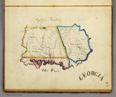
Author
Henshaw, Frances A.
Full Title
(Description of) Georgia.
List No
2501Q
Note
Text includes information on the state of Georgia, the Mississippi Territory, and West Florida.
Author
Schonberg & Co.
Full Title
Schonberg's Map of Georgia. Entered ... 1866 ... New York.
List No
5198.030
Note
Counties shown in color. Prime meridians Washington D.C. and Greenwich. Relief shown by hachures.
Author
Mitchell, Samuel Augustus
Full Title
(Covers to) Map Of The States Of North Carolina South Carolina and Georgia. Philadelphia: Published by S. Augustus Mitchell. 1836. Sold By Mitchell & Hinman No. 6 North Fifth Street. Entered ... 1835, by S. Augustus Mitchell ... Pennsylvania. Engraved by J.H. Young. (inset) Vicinity Of Charleston.
List No
0516.001
Note
First issued in Finley's American Atlas 1826, then reissued by Mitchell in 1831, this 1836 edition adds an inset of Charleston and tables of stage and steamboat routes . Folded into dark green leather covers 13.5x8 with "Mitchell's Map Of The Carolina's & Georgia" and a decorative border in gilt. Full color.
Author
Mitchell, Samuel Augustus
Full Title
Map Of The States Of North Carolina South Carolina and Georgia. Philadelphia: Published by S. Augustus Mitchell. 1836. Sold By Mitchell & Hinman No. 6 North Fifth Street. Entered ... 1835, by S. Augustus Mitchell ... Pennsylvania. Engraved by J.H. Young. (inset) Vicinity Of Charleston.
List No
0516.002
Note
First issued in Finley's American Atlas 1826, then reissued by Mitchell in 1831, this 1836 edition adds an inset of Charleston and tables of stage and steamboat routes . Folded into dark green leather covers 13.5x8 with "Mitchell's Map Of The Carolina's & Georgia" and a decorative border in gilt. Full color.
Author
Vandermaelen, Philippe, 1795-1869
Full Title
Partie des Etats Unis. Amer. Sep. no. 57. Dresse et dessinee par Ph. Vandermaelen, lithographie par H. Ode ... 1825. (Quatrieme partie. - Amer. sept. Bruxelles. 1827)
List No
2212.262
Note
Hand col. lithographed map. Relief shown by hachures. Shows Indian tribes, county boundaries, forests, etc. Covers Georgia, South Carolina and parts of North Carolina, Florida and Alabama.
Author
Shell Oil Company
Full Title
Shell Map of Georgia (cover title). Shell Highway Map of Georgia. 7-DD-1956-2.
List No
5840.025
Author
Shell Oil Company
Full Title
Savannah. Augusta. Macon. Chattanooga (Tennessee). Atlanta. (Verso to) Shell Highway Map of Georgia.
List No
5840.026
Author
Shell Oil Company
Full Title
Metropolitan Atlanta and Vicinity. (Verso to) Shell Street Map of Atlanta.
List No
5840.112
Author
Cram, George Franklin
Full Title
Railroad and County Map of Georgia. Geo. F. Cram. Engraver and Publisher, Chicago.
List No
4727.035
Note
Prime meridians Washington D.C. and Greenwich. Relief shown by hachures. With printed color.
Author
Cram, George Franklin
Full Title
Georgia.
List No
2809.043
Note
Locations of banking towns shown by red circles. Railroads are indicated by numbers and colors and patterns, and each railroad has the same number and color and pattern in every state through which it passes. All railroads on each map are in a list keyed to the map. Border of map has a table of contents for the atlas. Relief shown by hachures. Prime meridians Washington D.C. and Greenwich.
Author
[Carey, Mathew, Warner, Benjamin]
Full Title
Georgia.
List No
4864.025
Note
Prime meridians are from Philadelphia and London. Relief shown pictorially.
Author
Rand McNally and Company
Full Title
(Covers to) Rand McNally & Co.'s Georgia. Copyright, 1883, by Rand, McNally & Co., Map Publishers, Chicago ... (with 33 page index) Rand McNally & Co.'s Indexed County And Township Map Of Georgia... Chicago, U.S.A.: Rand McNally & Co. ... (on verso) Entered ... 1883, by Rand McNally & Co. ... Washington.
List No
4893.001
Note
Map is from the Indexed Atlas. Full printed color by county, folded into tan card board covers 17x10.5 cm. with same title as index printed in black. Prime meridians are Greenwich and Washington D.C.
Author
Rand McNally and Company
Full Title
(Title Page to) Rand McNally & Co.'s Georgia. Copyright, 1883, by Rand, McNally & Co., Map Publishers, Chicago ... (with 33 page index) Rand McNally & Co.'s Indexed County And Township Map Of Georgia... Chicago, U.S.A.: Rand McNally & Co. ... (on verso) Entered ... 1883, by Rand McNally & Co. ... Washington.
List No
4893.002
Note
Map is from the Indexed Atlas. Full printed color by county, folded into tan card board covers 17x10.5 cm. with same title as index printed in black. Prime meridians are Greenwich and Washington D.C.
Author
Rand McNally and Company
Full Title
Rand McNally & Co.'s Georgia. Copyright, 1883, by Rand, McNally & Co., Map Publishers, Chicago ... (with 33 page index) Rand McNally & Co.'s Indexed County And Township Map Of Georgia... Chicago, U.S.A.: Rand McNally & Co. ... (on verso) Entered ... 1883, by Rand McNally & Co. ... Washington.
List No
4893.003
Note
Map is from the Indexed Atlas. Full printed color by county, folded into tan card board covers 17x10.5 cm. with same title as index printed in black. Prime meridians are Greenwich and Washington D.C.
Author
[Breese, Samuel, 1802-1873, Morse, Sidney E. (Sidney Edwards), 1794-1871]
Full Title
Georgia. Entered ... 1842 by Sidney E. Morse and Samuel Breese ... New York. (New York: Published by Harper & Brothers, 1845)
List No
2301.026
Note
Col. wax engraved map. Relief shown by hachures. Prime meridians: Greenwich and Washington.
Author
[Bayer, Herbert, Container Corporation of America]
Full Title
Georgia. U.S. States. (inset) (Vicinity of Atlanta).
List No
5842.054
Note
Map and graphics showing principal resources, population, occupations, manufacturing, mineral production, agriculture, and land use. Includes brief history and description of state's features. Relief depicted by hachures.
Author
[Ogilby, John, 1600-1676, Montanus, Arnoldus, 1625?-1683, Moxon, James]
Full Title
A New Description of Carolina by Order of the Lords Proprietors.
List No
12241.044
Note
North to the right. Foldout.
Author
[Ogilby, John, 1600-1676, Montanus, Arnoldus, 1625?-1683]
Full Title
Virginiae Partis australis, et Floridae partis orientalis, interjacentiumq regionum Nova Descriptio .
List No
12241.045
Note
Inserted in this copy, present in the first issue 1671 but not published in this second issue 1671, replaced by the Lord Proprietors' map.
Author
Pirî Reis, d. 1554?
Full Title
fol. 371b Coastline of the Black Sea
List No
10108.754
Note
Author's name given on fol. 376b as Raʾīs al-Baḥr Pīrī ibn Muḥammad; author dates preferred by (Walters) cataloger: d. 962 AH / 1555 CE
Author
Carey, Mathew
Full Title
Georgia. W. Barker sc.
List No
4865.019
Note
Uncolored.
Author
Gautier d'Agoty, J.F. (Jean Fabien), 1717-1785
Full Title
(Southern Atlantic Seaboard, (United States))
List No
12495.009
Note
Part of volume 1. Foldout. This may be one of the earliest color printed maps of North America.
Author
Lloyd, H.H.
Full Title
Atlas of the United States. Florida, Georgia, and South Carolina. (by H.H. Lloyd. Published by Stedman, Brown & Lyon, Baltimore. 1873)
List No
2239.030
Note
Hand col. lithographed map. Counties in full color.
Author
Speed, John, 1542-1629
Full Title
A Map of Russia.
List No
12058.221
Author
Santini, Paolo
Full Title
59. Carte de la Partie Septentrionale de L'Empire Otoman (southeast sheet). L'Armenie, ;a Georgie, et la Daghistan.
List No
12039.073
Author
Santini, Paolo
Full Title
29. Carte de la Georgie.
List No
12039.109
Author
[Santini, Paolo, d'Anville]
Full Title
38. Carte de l'Empire de Perse.
List No
12039.119
Author
Meyer, Joseph, 1796-1856
Full Title
(United States of North America) : Die Staaten von N. & S. Carolina, Georgia & Florida. 1850. Aus der Geograph. Graviranstalt des Bibliograph. Instituts zu Hildburghausen. (in upper margin) Meyer's Zeitung Atlas. No. 76. (to accompany) Neuester Zeitungs-Atlas fur Alte und Neue Erdkunde. Herausgegeben von J. Meyer. (insets) Hafen von St. Augustine. (with) Gold-Region von Nord-Carolina. (with) Newberne. (with) Charleston.
List No
11652.095
Note
Engraved outline hand color map. Shows administrative boundaries, cities and towns. Relief shown by hachures. Prime meridians are Greenwich and Washington.
Author
Johnson, Alvin Jewett, 1827-1884.
Full Title
Johnson's Georgia and Alabama. Published by Alvin J. Johnson & Son, New York. Entered ... 1865, by A.J. Johnson ... New York. (to accompany) Johnson's New Illustrated Family Atlas Of The World ... MDCCCLXXX (1880).
List No
4830.081
Note
Engraved hand colored in outline map on 2 sheets. Shows state and county boundaries, state capitals, towns, roads, railroads, rivers and swamps. Depth shown by isolines. Prime meridians are Greenwich and Washington. Includes explanation.
Author
Mitchell, Samuel Augustus
Full Title
County map of Georgia, and Alabama. Entered ... 1870 by S. Augustus Mitchell, Jr. ... Pennsylvania.
List No
2483.022
Note
Hand colored. Relief shown by hachures. Shows settlements, railroads, etc. Prime meridians: Greenwich and Washington.
Author
Aitchison, R. T.
Full Title
Georgia. The Cracker State. The Mentholatum Company. Wilmington, Delaware. Copyright 1940 R.T. Aitchison.
List No
11883.000
Note
Pictorial map of Georgia, with 7 columns of historical text. Regions showing in different colors: coastal plain, coastal upland, upland plain and and highlands. Map showing towns, roads, railroads, agriculture industry, Native American settlements, rivers, mountains and landmarks. Relief shown pictorially and by spot heights. Historical events and places are identified on the map and in the surrounding text.
Author
Mitchell, Samuel Augustus
Full Title
County map of the states of Georgia and Alabama. (with) Savannah, Georgia. (with) City of Atlanta, the capitol of Georgia. Entered ... 1879 by S. Augustus Mitchell ... Washington. (1880)
List No
0586.024
Note
Hand colored with 2 insets. Shows settlements, railroads, rivers, etc. Prime meridians: Greenwich and Washington.
Full Title
The state of Georgia. Gridley sc. (Philadelphia: Robert DeSilver, 1827)
List No
0239.000
Note
Updated from M. Carey's 1818 edition General Atlas. Many changes: coastline, rivers, counties, towns. Map is missing a piece in the upper right corner -- supplied in facsimile. Outline color by county. Relief shown by hachures. "20." Prime meridians: Philadelphia and London.
Author
Rodini, Giuseppe
Full Title
Carta Generale della Russia Europea e delle Provincie Asiatiche al sud del Caucaso.
List No
12502.018
Author
Treasure Map
Full Title
Home of Jimmy Carter, our 39th Pres. Plains, GA. Copyright 1976. (on verso) Georgia : state highway system and connections. January 1975-6. Produced by : Treasure Map. Daytona Beach, Florida. (insets) Savannah. (with) Macon. (with) Augusta. (with) Columbus.
List No
11764.001
Note
2 maps on one sheet, both sides. Including: Uncolored map of Georgia highway system. Showing administrative boundaries, cities, towns, roads, railways, etc. Includes lists of counties, camping areas and index to cities and towns. On verso: Pictorial map of Plains, Georgia, the hometown of former president Jimmy Carter, issued as a souvenir for his presidential inauguration on January 20, 1977. The map has illustrations of his home, shops, schools, a railroad, and other buildings. The circular cartouche lower right bears the seal of the United States and states that the map shows the town as it appeared as of December 5, 1976. Text in upper left, is addressed to the citizens of Plains, Georgia, with recommended behavior at the inaugural in Washington ...
Author
Treasure Map
Full Title
Georgia : state highway system and connections. January 1975-6. Produced by : Treasure Map. Daytona Beach, Florida. (insets) Savannah. (with) Macon. (with) Augusta. (with) Columbus. (on verso map) Home of Jimmy Carter, our 39th Pres. Plains, GA. Copyright 1976.
List No
11764.002
Note
2 maps on one sheet, both sides. Including: Uncolored map of Georgia highway system. Showing administrative boundaries, cities, towns, roads, railways, etc. Includes lists of counties, camping areas and index to cities and towns. On verso: Pictorial map of Plains, Georgia, the hometown of former president Jimmy Carter, issued as a souvenir for his presidential inauguration on January 20, 1977. The map has illustrations of his home, shops, schools, a railroad, and other buildings. The circular cartouche lower right bears the seal of the United States and states that the map shows the town as it appeared as of December 5, 1976. Text in upper left, is addressed to the citizens of Plains, Georgia, with recommended behavior at the inaugural in Washington ...
Author
[Stieler, Adolf, Kehnert, H., Habenicht, H.]
Full Title
49. Russland, Bl. 6. Eurpaeisches Russland und Nord-Skandinavien in 6 Blaettern.
List No
0961.110
Author
[Handtke, F., Flemming, Carl, Sohr, Karl]
Full Title
Karte vom Kaukasus ...
List No
12206.064
Note
Foldout.
Author
[Black, Adam, Black, Charles]
Full Title
Georgia & Florida.
List No
1585.067
Full Title
County map of the states of Georgia and Alabama. (with) Savannah, Georgia. (with) City of Atlanta, the capitol of Georgia. Copyright 1887 by Wm. M. Bradley & Bro. (1890)
List No
0594.025
Note
Hand colored with 2 insets. Shows settlements, railroads, rivers, etc. Prime meridians: Greenwich and Washington.
Author
Rand, McNally & Co.
Full Title
Georgia.
List No
9733.073
Author
[Stieler, Adolf, Haack, H.]
Full Title
59. Kaukasien.
List No
12248.127
Author
[Stieler, Adolf, Haack, H.]
Full Title
65. Armenien - Mesopotamien - Iran.
List No
12248.139
Author
[Stieler, Adolf, Kehnert, H., Habenicht, H.]
Full Title
(Composite Map) Nr. 44-49. Europaisches Russland und Nord-Skandinavien in 6 Blaettern. ... von H. Kehnert und H. Habenicht.
List No
0962.111
Author
Zatta, Antonio, active 1757-1797
Full Title
Luigiana Inglese, colla Parte Occidentale della Florida, della Giorgia, e Carolina Meridonale. Le Colonie Unite dell' America Settentrle. Fogl. XI. (to accompany) Atlante novissimo ... Tomo IIII. Con privilegio dell Eccelimo Senato. (tomo I-IV).
List No
11598.235
Note
Engraved hand-colored in outline, double-page map. The first edition of Zatta's twelve sheet version of Mitchell's Map of North America, plus three other maps: Il Canada, La Baja D' Hudson, and Le Isole di Terra Nuova e Capo Breton. Zatta's version of Mitchell is not an exact copy: many geographical changes are introduced, and Bermuda is depicted as well as Jamaica, neither of which are shown by Mitchell. Maps showing administrative divisions, settlements, cities, towns, forts, Indian settlements, bridges, canals, mountains and rivers. Relief shown pictorially and by hacures. Includes notations.
Author
Finley, Anthony
Full Title
Georgia. Young & Delleker Sc. Published by A. Finley, Philada. (to accompany) A New General Atlas Comprising a Complete Set of Maps, representing the Grand Divisions Of The Globe ... Philadelphia: Published by Anthony Finley. 1827.
List No
0282.025
Note
Full color map on sheet 35x27. Relief shown pictorially. Prime meridians are Washington and Greenwich. Shows counties, major cities, roads and rivers.
Author
Taintor Brothers & Merrill
Full Title
Map of the State of Georgia.
List No
9731.021
Author
Piadyshev, Vasilii Petrovich, 1758-1835
Full Title
Generalnaia karta Gruzii : S pokazaniem pochtovykh i bolshikh proezzhikh dorog, stantsii i razstoianiia mezhdu onymi verst. Sochinena po noveishim i dostovernym svedeniiam, v S-t Peterburge 1829 goda = Carte generale de la Georgie. Sochinil i grav. Piadyshev. Vyr. Slova Frolov. (to accompany) Geograficheskii atlas Rossiiskoi Imperii = Atlas geographique de l' empire de Russie. No.45.
List No
11233.048
Note
Engraved hand colored in outline map. Showing provincial and district borders, rivers, roads, postal tracks and stations, landmarks, churches, major cities, towns, villages, etc. Distances are shown in versts. Legend and place names in Russian and French. Relief shown by hachures.
Full Title
North Carolina, South Carolina and Georgia. (with) Charleston and vicinity. N. & S.S. Jocelyn Sc. (New-Haven: N. & S.S. Jocelyn. 1823)
List No
4869.007
Note
Engraved map with inset and facing index page. Outline hand color. Relief shown by hachures. Prime meridians: Washington and Greenwich.
Author
[Weiland, Carl Ferdinand, 1782 -1847, Hassel, Georg, 1770-1829]
Full Title
Geographisch-statistische und historische Charte von Georgia.
List No
12293.019
Author
Greenleaf, Jeremiah
Full Title
Georgia.
List No
4850.052
Note
Full color county.
Author
Hughes, Andrew
Full Title
A Draught of South Carolina and Georgia from Sewee to St. Estaca.
List No
12434.039
Note
Foldout.
Author
[Gaspari, Adam Christian (1752-1830), Reinecke, I.C.]
Full Title
XLIII. Persien. (Persia.)
List No
9535.047
Note
Foldout.
Author
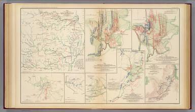
[Michler, Nathaniel, United States. War Department]
Full Title
Battle-field of Youngs Branch or Manassas Plains, battle fought July 21st, 1861. Tracing forwarded to the Chief of Engineers U.S.A. by Maj. N. Michler ... Map of the rebel fortifications at Columbus, Ky., surveyed under the direction of Brig. Genl. Geo. W. Cullum, Chief of Staff and engineers, Dept. of the Mississippi, 1862. (with) Map showing the position of the batteries used by the U.S. forces in the reduction of Fort Pulaski, April 10th & 11th, 1862. Accompanying Report of Brig. Gen. Quincy A. Gillmore, U.S. Vols. (with) Siege of Fort Pulaski, map of the mouth of Savannah River and adjacent islands ... (with) Action at Front Royal, Va., May 23d. 1862. Accompanying Report of Lieut. Col. Charles Parham, Twenty-ninth Pennsylvania Infantry. (with) Sketch of Fort Pickens, Florida, by Lt. Langdon ... 1861. (with) Reconnaissance of the battle-field at Bull Run, Va., fought July 21, 1861. Made on March 14, 1862 by Henry L. Abbot ... (with) Skirmishes near Bailey's Cross-roads, Va., August 28-30, 1861. Accompanying Report of Major S.G. Champlin ... (with) Accompanying Report of Brig. Gen. Louis Blenker, U.S. Vols., of information obtained from scouting parties, dated Hunter's Chapel, Va., Nov. 5, 1861. Julius Bien & Co., Lith., N.Y. (1891-1895)
List No
1780.005
Note
Two col. maps with 8 ancillary maps. Relief shown by contours, hachures and spot heights. Scales of main maps ca. 1:26,400 and 1:14,400.
Author
[Michler, Nathaniel, United States. War Department]
Full Title
10. New map of Tennessee by Capt. Michler, Topl. Engineers, U.S.A. (with) 9. Topographical sketch of the battle-field of Stone's River near Murphreesborough, Tenn., December 31st 1862 to January 3d. 1863. Maj. Gen. W.S. Rosecrans ... Forces of the United States. General Braxton Bragg commanding enemy's forces. (with) Position of 1st Division 3rd Corps at noon December 13, 1862. Drawn by direction of Brig. Gen. D.B. Birney ... (by) J.C. Briscoe ... (with) Position held by the 1st Division 3rd Corps after having repulsed the enemy December 13, 1862. Drawn by direction of Brig. Gen. D.B. Birney ... (by) J.C. Briscoe ... (with) Map of Huntersville line commanded by Col. Wm. L. Jackson. (with) Sketch showing the positions of Liddell's division consisting of Walthall's and Govan's brigades in the Battle of Chickamauga, September 18, 19 and 20, 1863. Accompanying report of Brig. Gen. St. John R. Liddell, C.S. Army. Julius Bien & Co., Lith., N.Y. (1891-1895)
List No
1780.030
Note
Col. map with 5 ancillary maps. Relief shown by hachures.
Author
United States. War Department
Full Title
Map of the approaches to Petersburg and their defenses, 1863. By order of the Engineer Bureau, Col. J.F. Gilmer ... Col. W.H. Stevens ... Capt. Chas. H. Dimmock, C.S.E., in charge of defenses, Petersburg, Va. Map of the battle-field of Gettysburg, Pa. July 1, 2 and 3, 1863. (with) B. Sketch showing route of the Burnside Expedition. Accompanying report of Maj. Gen. J.G. Foster, C.S. Army ... (with) C. Sketch showing the route to New Berne pursued by the Burnside Expedition, March 13 and 14, 1862. (with) Map showing the positions of Maj. Gen. S.G. French's forces at Lovejoy's Station, Ga. from Sept. 3d. to Sept. 8th, 1864. Julius Bien & Co., Lith., N.Y. (1891-1895)
List No
1780.040
Note
Two col. maps with 3 ancillary maps. Relief shown by hachures.
Author
[Brown, S. Howell, Confederate States of America. Army of Northern Virginia, Confederate States of America. Army]
Full Title
Map of the battle-field of Gettysburg with positions of troops, July 2nd, 1863. Topl. Office, A.N.V., by L. Howell Brown ... copied by Hoffmann. Accompanying report of Gen. R.E. Lee, C.S. Army. (with) Sketch of the battle of Gettysburg, July 1st, 2nd and 3rd, 1863 to accompany report of Lieut. Gen. R.S. Ewell ... by Jed. Hotchkiss. (with) Sketch of the second battle of Winchester, June 13th, 14th and 15th, 1863 ... by Jed. Hotchkiss. (with. Marietta Region) Accompanying report of Brig. Gen. K. Garrard. (with Dallas Region) Marked "McPherson" by Gen. Sherman. (with Dallas Region) Marked "McPherson" by Gen. Sherman. (with) Sketch of routes, 2nd Corps A.N.V. from Fredericksburg, Va. to Gettysburg, Pa. and return to Orange C.H., Va. from June 4th 1863 to August 1st, 1863. To accompany report of Lieut. Gen. R.S. Ewell ... by Jed. Hotchkiss. (with) Texas Coast showing points of occupation of expedition under Maj. Gen. N.P. Banks, November 1863. (with Dallas Region). Marked "McPherson" by Gen. Sherman. Julius Bien & Co., Lith., N.Y. (1891-1895)
List No
1780.043
Note
Col. map with 8 ancillary maps. Relief shown by hachures.
Author
[Ruger, Edward, United States. War Department]
Full Title
Sheet no. 1. Map of the battle-field of Chickamauga, September 19th, 1863 between the United States forces commanded by Maj. Gen. W.S. Rosecrans and the rebel army under Gen. Braxton Bragg. Compiled under the direction of Col. W.E. Merrell ... by Edward Ruger ... Sheet no. 2. Map of the battle-field of Chickamauga, September 20th, 1863 ... (with) Map showing the expedition of the 15th Army Corps, Maj. Gen. P.J. Osterhaus, commanding, Turkeytown Valley, Ala., October 24-26, 1864. (with) Battle of Chickamauga, Walker Co., Georgia, Sept. 19 and 20, 1863. From original in the possession of General Braxton Bragg, C.S. Army. Julius Bien & Co., Lith., N.Y. (1891-1895)
List No
1780.046
Note
Two col. maps with 2 ancillary maps. Relief shown by hachures. Includes tables of commanders, descriptive notes and list of authorities.
Author
[Morris, Walter J., United States. War Department]
Full Title
Map of the fall campaigns of the Army of Missouri, Maj. Gen. Sterling Price, commanding in Sept., Oct., Nov. 1864. Capt. T.J. Mackey, Chf. Engr. (with) No. 2. Map of the battle of Chickamauga showing the positions of the Confederate and Federal armies on the 19th September, 1863 ... by Walter J. Morris ... (with) No. 3. Map of the battle of Chickamauga ... 19th September 1863 ... by Walter J. Morris ... (with Marietta Region, Georgia). Accompanying letter of Maj. Gen. J.M. Scholfield ... (with Peach Tree Creek Region, Georgia) Marked "Thomas" by Gen. Sherman. (with) Mine Run, Va. and vicinity, 1863. (with) No. 1. Map showing the positions of the Confederate Army and that of the Federal Army at midnight on the 18th of September, 1863, the night previous to the general engagements of the 19th and 20th Sept., or the Battle of Chickamauga ... by Walter J. Morris ... (with) Map of the engagement at Wauhatchie, Tenn., October 28th and 29th, 1863 and of the operations of the 11th and 12th Army Corps preliminary thereto. Accompanying report of Maj. Gen. Joseph Hooker. Julius Bien & Co., Lith., N.Y. (1891-1895)
List No
1780.047
Note
Col. map with 7 ancillary maps. Relief in some ancillary maps shown by hachures or form lines.
Author
[Anstey, E. G., Confederate States of America. Army, Rockwell, Cleveland, United States. War Department]
Full Title
Map no. 1. The Chickamauga Campaign, August 16-September 22, 1863. E.G. Anstey, draughtsman. Accompanying report of Gen. Braxton Bragg, C.S. Army. Topographical map of the approaches and defenses of Knoxville, E. Tennessee, showing the positions occupied by the United States and Confederate forces during the siege. Surveyed by direction of Capt. O.M. Poe ... during Dec., Jan. and Feb., 1863-4 by Cleveland Rockwell, Sub. Asst., U.S. Coast Survey, R.H. Talcott, aide. (with Dallas Line, Georgia). Accompanying letter of Maj. Gen. Jas. B. McPherson ... (with Dallas Line, Georgia). Original marked "McPherson May 27." From original in possession of Gen. W.T. Sherman. (with) Sketch of roads from Gen. McCook's hdqrs. near junction of Acworth and Dallas and Marietta roads to Acworth and Big Shanty and R.R. ... 1864. From original in possession of Gen. W.T. Sherman. Julius Bien & Co., Lith., N.Y. (1891-1895)
List No
1780.048
Note
Two col. maps with 3 ancillary maps. Relief shown by hachures and form lines.
Author
[Howard, Oliver O., Mergell, C. S., United States. War Department]
Full Title
Map of the battle-field of Chattanooga. Prepared to accompany report of Maj. Gen. U.S. Grant. By direction of Brig. Gen. W.F. Smith ... 1864. Compiled and drawn by C.S. Mergell. Position of troops, etc. drawn by E. Hergesheimer. Map accompanying report of Maj. Gen. O.O. Howard. (with) McPherson's crossing at Roswell. From original in possession of Gen. W.T. Sherman. (with Marietta Region by) C.W. Skinner. Accompanying letter of Brig. Gen. Garrard. (with Chattahoochee River) marked "Schofield" in Gen. Sherman's handwriting. Julius Bien & Co., Lith., N.Y. (1891-1895)
List No
1780.049
Note
Two col. maps with 3 ancillary maps. Relief shown by contours and hachures.
Author
[Bush, H. M., United States. War Department]
Full Title
Map of the country between Vicksburg and Meridian, Miss. showing the route followed by the Seventeenth Army Corps under the command of Maj. Gen. J.B. McPherson in February, 1864. Surveyed by Lt. H.M. Bush and assistants S. Davis and S.W. Dunning under the direction of Capt. A. Hickenlooper, Chf. Engr. (with) Sketch of the city of Atlanta and line of defenses. L.P. Grant, Capt. Engs. (with) Sketch of battery. L.P. Grant, Capt. Engs. (with) Map of Smith's Island, N.C. Prepared under the direction of Capt. Wm. H. James, Chf. Engr. by Lieut. B.L. Blackford, Top. Engr., Nov., 1863. Accompanying letter of Maj. Gen. W.H.C. Whiting, C.S. Army. Julius Bien & Co., Lith., N.Y. (1891-1895)
List No
1780.051
Note
Col. map with 3 ancillary maps. Relief shown by hachures.
Author
United States. War Department
Full Title
Map of the battle-field of the Wilderness, Va., May 5th, 6th and 7th., 1864 showing the field of operations of the Army of the Potomac commanded by Gen. George G. Meade, U.S.A. Surveyed under the orders of Bvt. Col. J.C. Duane ... by Bvt. Maj. C.W. Howell ... Assisted by Messrs. L. C. Oswell, L. Bell and R.B. Talfor. Map of the battle-field of Spotsylvania C.H., Va. ... From May 8th to 21st, 1864. Surveyed under the orders of Bvt. Col. J.C. Duane ... by Bvt. Maj. C. W. Howell ... Assisted by Messrs L.C. Oswell, L. Bell and R.B. Talfor. Map of the country in the vicinity of Todd's Tavern, Va. with the position of the 2nd Corps, Army of the Potomac, May 8th, 1864 ... Map of the battle-fields of North Anna ... from May 3d to 27th, 1864 .. Map of the battle-fields of the Totopotomoy and Bethesda Church, Va. ... from May 28th to June 2d 1864 ... Positions of the Army of the Ohio in front of Dalton, Ga., May 8 and 9, 1864. Accompanying letter of Maj. Gen. J.M. Schofield, U.S. Army. Julius Bien & Co., Lith., N.Y. (1891-1895)
List No
1780.055
Note
Six col. maps. Relief shown by hachures.
Author
United States. War Department
Full Title
Map of the vicinity of Petersburg, Va., 1862. "Copy of map furnished General Gillmore ... June 9, 1864." Accompanying letter of Maj. Gen. B.F. Butler ... (with) No. 15. The Atlanta Campaign, operations of the 4th Army Corps from June 15th to July 3d 1864. Accompanying report of Maj. Gen. O.O. Howard ... (with) No. 16. The Atlanta Campaign, operations of the 4th Army Corps from July 3d to 5th 1864. (with) No. 17. The Atlanta Campaign, operations of the 4th Army Corps from July 5th to 18th 1864. (with) Position of the Army of the Tennessee from May 27th to June 4th 1864. (with) Battle ground of the Army of the Tennessee under command of the late Maj. Gen. James B. McPherson before Atlanta, Ga., July 22d 1864. (with) Battle-ground of the Army of the Tennessee under the command of Maj. Gen. O.O. Howard before Atlanta, Ga., July 28th 1864 ... C.B. Reese, Capt. of Engineers ... (with) No. 18. The Atlanta Campaign, operations of the 4th Army Corps from July 18th to 27th 1864. Julius Bien & Co., Lith., N.Y. (1891-1895)
List No
1780.056
Note
Col. map with 7 ancillary maps. Relief shown by hachures.
Author
United States. War Department
Full Title
Map illustrating the operations of the Army under command of General W.T. Sherman in Georgia From May the 5th to September the 4th 1864. Compiled and drawn under the direction of Bvt. Brig. Gen. O.M. Poe ... by J. v. Glumer. Map illustrating the first epoch of the Atlanta Campaign. Embracing the region from the Tennessee River to the Oostanaula River ... Commanding United States forces Major-General W.T. Sherman, commanding rebel forces Lieut. General J.E. Johnston. Compiled by Edward Ruger. Map showing the roads followed by the Army of the Tennessee in its march from Chattanooga, Tenn. to Atlanta, Ga. ... Made under the direction of Capt. C.B. Reese ... Drawn and compiled by Capt. I. Helmle ... Accompanying report of Maj. Gen. O.O. Howard ... Julius Bien & Co., Lith., N.Y. (1891-1895)
List No
1780.057
Note
Three col. maps. Relief shown by hachures.
Author
[Ruger, Edward, United States. War Department]
Full Title
Map illustrating the second epoch of the Atlanta Campaign. Embracing the region from Resaca to the Etowah River ... Commanding United States forces, Major-General W.T. Sherman. Commanding rebel forces, Lieut. General J.E. Johnston. Compiled by Edward Ruger. (with) Map showing the march of the 15th Army Corps, Maj. Gen. John A. Logan, com'd'g., through Northern Georgia in the campaign of 1864. (with) Plate 1. Position of the 15th Army Corps, Army of the Tennessee, before and during the siege of Resaca, Ga., May 10th till May 16th 1864. (with) Plate II. Position of the 15th Army Corps from the 27th to the 31st of May, 1864. (with) Plate III. Position of the 15th Army Corps, Army of the Tennessee near New Hope Church, Ga., on June the 4th, 1864. (with) Plate IV. Showing the different positions of 15th Army Corps, Maj. Gen. John A. Logan, commanding, during the siege of Kenesaw Mountain, Ga. from June 10th till July 3d 1864. Julius Bien & Co., Lith., N.Y. (1891-1895)
List No
1780.058
Note
Col. map with 5 ancillary maps. Relief shown by hachures.
Author
[Ruger, Edward, United States. War Department]
Full Title
Map illustrating the third epoch of the Atlanta Campaign. Embracing the region from the Etowah River south to include Marietta and Dallas ... Commanding United States forces, Major-General W.T. Sherman, commanding rebel forces, Lieutenant-General J.E. Johnston. Compiled by Edward Ruger. (with) Positions, 4th Division, 16th Army Corps June 11th to 22nd 1864. Accompanying report of Brig. Gen. John W. Fuller. (with) Position, 4th Division, 16th Army Corps, July 4, 1864. (with) Positions, Fourth Division, 16th Army Corps, May 13 to 16, 1864 at Resaca, Ga. (with) Position, 4th Division, 16th Army Corps, May 27, 1864. (with) Plate VII. Position of the 15th Army Corps before Jonesborough, Ga. from August 30th to September 2d, 1864. Accompanying report of Maj. Gen. John A. Logan. (with) Plate VI. Position of the 15th Army Corps before Atlanta, Ga. from July 28th to August 26th 1864. (with) Plate V. Position of the 15th Army Corps, Maj. Gen. John A. Logan, com'd'g. at Nickajack Creek, Ga. from July 7th to 10th 1864. (with) Position of the 1st Division, 15th Army Corps near Jonesborough, Ga. Maj. Gen. P.J. Osterhaus, comm'd'g. Julius Bien & Co., Lith., N.Y. (1891-1895)
List No
1780.059
Note
Col. map with 8 ancillary maps. Relief shown by hachures.
Author
[Ruger, Edward, United States. War Department]
Full Title
Map illustrating the fourth epoch of the Atlanta Campaign. Embracing the region from Pine, Lost and Kenesaw mountains south to include Atlanta and its environs ... Commanding United States forces, Major-General W.T. Sherman, commanding rebel forces, Lieutenant-General J.E. Johnston, relieved by Lieutenant-General J.B. Hood. Compiled by Edward Ruger. Map illustrating the fifth epoch of the Atlanta Campaign. Embracing the region from the Chattahoochee River south to include Jonesborough and Lovejoy's Station ... Julius Bien & Co., Lith., N.Y. (1891-1895)
List No
1780.060
Note
Two col. maps. Relief shown by hachures.
Author
United States. War Department
Full Title
Topographical sketch of the battle of Bethel, Va., June 10th, 1861. (with) Position, Left Wing, 16th Army Corps, September 3d to 5th, 1864 near Lovejoy's Station, Ga. (with) July 22, 1864. To accompany official report of Maj. Gen. Frank P. Blair ... by Lieut Levi Coffman. (with) Position of the 17th Army Corps before Atlanta, Ga., July 22d 1864 ... (with) Position near Jonesborough, Ga. occupied by 2nd Division, 15th Army Corps from August 30th to September 2, 1864. (with) Sketch of the siege of Blakely, Ala. invested April 2d. by the forces under Maj. Gen. F. Steele. Assault April 9th 1865. Drawn by Gen. C.C. Andrews, May 1866. (with) Position of the Left Wing, 16th Army Corps near Jonesborough, Ga. (with) Position of the Left Wing, 16th Army Corps, September 10, 1864. (with) Line of march of Left Wing, 16th Army Corps from April 29 to May 4, 1864. (with) Position, Left Wing, 16th Army Corps, Resaca, Ga., May 14th, 15th and 16th, 1864. (with) Position, Left Wing, 16th Army Corps ... July 4, 1864. (with) Position, 16th Army Corps, May 16, 1864. (with) Position, Left Wing, 16th Army Corps ... May 26 to June 1st 1864. (with) Position, Left Wing, 16th A.C. near Owen's Mill, Ga., June 1st to 5th 1864. (with) Position of 16th Army Corps from July 26th to August 26th 1864. Julius Bien & Co., Lith., N.Y. (1891-1895)
List No
1780.061
Note
Col. map with 14 ancillary maps. Relief shown by hachures (on most ancillary maps). Maps accompany reports of F.P. Blair, G.M. Dodge, W.B. Hazen and T.E.G. Ransom.
Author
[Morse, Charles W., Colby, Charles A.]
Full Title
Georgia.
List No
0623.025
Author
United States. War Department
Full Title
Line of march of the Left Wing, 16th Army Corps from May 5th to Sept. 8th, 1864. (with) Position of the Left Wing, 16th A.C. ... July 11, 1864. (with) Map showing the position of Left Wing, 16th Army Corps during the engagement near Atlanta July 22, 1864. (with Atlanta Campaign). (with) Diagram of the battle-field occupied by Gen. Blair, 17th Army Corps ... July 5th to 11th 1864 on the Chattahoochee. (with) Position of Left Wing ... in front of Kenesaw Mountain. (with) Map showing position of the Confederate armies of Mississippi and Tennessee under command of Gen. J.E. Johnston May 19th 1864. (with) Position of 4th Div., 17th Army Corps, July 22d, 1864. (with) Diagram of the general situation during the siege of Atlanta. (with Marietta Ga. June 10-July 3, 1864). (with) Diagram showing the advance of the 3d. Brig., 4th Div., 17th Corps on the Sandtown Road to Widow Mitchell's farm and from there east to the Nickajack. July 3, 4 and 5th 1864. (with) Diagram showing the flank movement of the 17th Army Corps from Turner's Ferry, July 16, 1864, by way of Marietta and Roswell to south of Decatur and east of Atlanta to the extreme left of the Army. (with Marietta, Ga. June 10-July 3, 1864). (with Marietta Ga. June 10-July 3, 1864). Julius Bien & Co., Lith., N.Y. (1891-1895)
List No
1780.062
Note
Col. map with 13 ancillary maps. Relief shown by hachures. Maps accompany documents from or in possession of G.M. Dodge, J.S. Fullerton, W.T. Sherman and J.M. Schofield
Author
[Palfrey, John C., United States. War Department]
Full Title
"A." Plan of siege operations against Fort Morgan, Ala., by the U.S. forces under Maj. Gen. Gordon Granger, August, 1864. Capt. John C. Palfrey, Corps of Engr's.. Lieut. A.H. Burnham, Lieut. Chas. J. Allen ... in charge of works. Surveyed and drawn by Capt. W.H. Wheeler, Lt. S.E. McGregory ... (with) Diagram of battle-field at Harrisburg, Miss. Battle fought July 14th, 1864. Drawn by Capt. D.W. Wellman. (with) Map of the roads and adjacent country between Stubb's Plantation and Brice's Cross-roads, Miss. (with) Snake Creek Gap, Ga. (with) Sketch of vicinity of 2d. Cav. Div. camp. K. Garrard ... (with) Defense of Fort Morgan by Brig. Gen. R.L. Page, P.A.C.S., August 1864. A true copy of the engineers' record, J. Gallimard ... (with) Defense of Fort Morgan, entrance of Mobile Bay ... (with) Map of the battle of Fredericksburg, Va., December 13, 1862. (with) Map of battle-field of Mechanicsville and Cold Harbor, Va. Julius Bien & Co., Lith., N.Y. (1891-1895)
List No
1780.063
Note
Col. map with 7 ancillary maps. Relief shown by hachures. Map of Harrisburg "To accompany report of Brig. Gen. J.A. Mower, U.S. Army."
Author
[United States. War Department, Walker, Tipton]
Full Title
Coast of Texas and its defenses, Capt. Tipton Walker, Chief of Topographical Bureau of Texas, New Mexico and Arizona, drawn by P. Helferich, Asst. Engr. 1864. (with) Engineer Office, 10th Army Corps, sketch no. 8 of road between Bermuda Hundred and enemy's first line of intrenchments on the north and Petersburg on the south. T.B. Brooks, Maj. A.D.C. and Directing Engineer. (with Marietta, Ga., June 10-July 3, 1864). Original marked "Thomas and Schofield." (with Marietta, Ga., June 10-July 3, 1864). Original marked "Garrard." (with) Schofield crossing the Chattahoochee. (with Marietta, Ga., June 10-July 3, 1864). (with) No. 3. Sketch of defensive works at Deep Bottom, Va. (with) Section through Dutch Gap, James River, Va. (with) Plan of Dutch Gap Canal and fortifications, James River, Va., Sept. 10, 1864. P.S. Michie. (with) No. 2. Sketch of road from pontoon-bridge at Point of Rocks to Petersburg, showing line of works captured by 18th Army Corps. Julius Bien & Co., Lith., N.Y. (1891-1895)
List No
1780.065
Note
Col. map. with 9 ancillary maps. Relief on some ancillary maps shown by hachures. Includes drawings of 14 fortifications at 1:10,000. Accompanying reports or letters of G. Weitzel and J.M. Schofield or in possession of W.T. Sherman.
Author
[Gillespie, George L., United States. War Department]
Full Title
Engineer Office, Military Division of the Gulf. Map no. 5. Upper Potomac from McCoy's Ferry to Conrad's Ferry and adjacent portions of Maryland and Virginia showing the operations of the Army of the Shenandoah. Commanded by Maj. Gen. P.H. Sheridan, U.S.A. Drawn and lithographed under the direction of Bvt. Maj. G.L. Gillespie ... October 1865. (with) Sheet no. 2. Map of the battle-field of Cedar Creek, Va. fought Oct. 19th, 1864 and cavalry fight of Tom's Brook fought Oct. 9th 1864. Union forces commanded by Maj. Gen. P.H. Sheridan, U.S.A. Confederate forces commanded by Lieut. Gen. J.A. Early, C.S.A. Drawn and lithographed under the direction of ... Col. G. Gillespie ... (with) Map showing the march routes of the Army of the Tennessee from Atlanta to Savannah during the campaign in Georgia, under the command of Maj. Gen. O.O. Howard. Compiled and drawn under the direction of Capt. C.B. Reese ... by L. Helmle ... (with) Plate showing positions of the 15th Army Corps, Maj. Gen. P.J. Osterhaus, commanding in front of Savannah, Ga., Dec. 1864. Drawn by C. v. Seutter. Julius Bien & Co., Lith., N.Y. (1891-1895)
List No
1780.069
Note
Two col. maps (with same title) and 3 ancillary maps. Relief shown by hachures.
Author
[Hader, Berta Hoerner (1890-1976), Hader, Elmer Stanley (1889-1973]
Full Title
Alabama. Georgia.
List No
8763.026
Author
Homann, Johann Baptist, 1663-1724
Full Title
Turcia Asiatica exhibems Natoliam Modernam.
List No
9753.093
Author
Homann, Johann Baptist, 1663-1724
Full Title
Dominia Anglorum in America Septentrionali. Die gros Britannische Colonie-Laender in Nord America. New Foundland, New England, Virginia und Maryland, D. Carolina.
List No
9753.106
Note
Based on four maps from Herman Moll's Atlas Minor (see our copy).
Author
Seutter, Matthaeus, 1678-1756
Full Title
44. (Coasts of South Carolina, Georgia, Florida. Savannah mills).
List No
12040.109
Note
This map is part of the following map, Plan von Neu Ebenezer. Ruderman: "Important early town plan of New Ebenezer on the Savannah River, accompanied by a large map of the region from Charleston and Augusta, GA in the north to Saint Augustine, Florida, with a smaller inset map of St. Simons River, and Great St. Simon's Island and Jekyl Isle. The map was prepared for Samuel Urlsperger's Ausfürhliche Nachrichten von den saltzburgischen emigranten, published by Matthaeus Seutter, 1747. The map illustrates one of the most interesting early colonies in the southeast. The Salzburgers were a group of Lutherans who were exiled from their homeland in Salzburg, Austria. In 1734, the English Society for Promoting Christian Knowledge sponsored the sea passage of a small group of them to America. Their first settlement, on the Ebenezer River, proved inhospitable, so in 1736 they moved to the banks of the Savannah River, where they founded New Ebenezer. With Savannah, founded only three years earlier, as a model, New Ebenezer was laid out on a grid pattern, punctuated by open squares and became a thriving locale known for its silk trade. It is now an archaeological site listed on the National Register of Historic Places; only the brick Jerusalem Lutheran Church and a few other buildings survive."
Author
Seutter, Matthaeus, 1678-1756
Full Title
44.(Composite of) Plan von Neu Ebenezer (with) (Coasts of South Carolina, Georgia, Florida. Savannah mills.)
List No
12040.121
Note
Composite of Plan von Neu Ebenezer and the adjoining (Coasts of South Carolina, Georgia, Florida. Savannah mills). Ruderman: "Important early town plan of New Ebenezer on the Savannah River, accompanied by a large map of the region from Charleston and Augusta, GA in the north to Saint Augustine, Florida, with a smaller inset map of St. Simons River, and Great St. Simon's Island and Jekyl Isle. The map was prepared for Samuel Urlsperger's Ausfürhliche Nachrichten von den saltzburgischen emigranten, published by Matthaeus Seutter, 1747. The map illustrates one of the most interesting early colonies in the southeast. The Salzburgers were a group of Lutherans who were exiled from their homeland in Salzburg, Austria. In 1734, the English Society for Promoting Christian Knowledge sponsored the sea passage of a small group of them to America. Their first settlement, on the Ebenezer River, proved inhospitable, so in 1736 they moved to the banks of the Savannah River, where they founded New Ebenezer. With Savannah, founded only three years earlier, as a model, New Ebenezer was laid out on a grid pattern, punctuated by open squares and became a thriving locale known for its silk trade. It is now an archaeological site listed on the National Register of Historic Places; only the brick Jerusalem Lutheran Church and a few other buildings survive."
Author
[Sanson, Nicolas, 1600-1667, Sanson, Guillaume (1633-1703)]
Full Title
Colchis, Iberia, Albania.
List No
9741.161
Full Title
N. & S. Carolina, Georgia & Florida. J.H. Young Sc. (Philadelphia: John Grigg, No. 9 North Fourth Street. 1830)
List No
0315.007
Note
Engraved map. Full hand color. Relief shown pictorially. Prime meridians: Greenwich and Washington.
Author
[State Farm Insurance Companies Travel Bureau, Rand McNally and Company]
Full Title
Rand McNally Road map, Georgia. Copyright by Rand McNally & Company, Chicago, Ill. Lithographed in the U.S.A. (to accompany) State Farm Road Atlas: United States, Canada, Mexico,Central and South America. Copyright 1940 by Rand McNally & Company, Chicago, Ill.
List No
5969.027
Note
Color map. U.S. interstate highways shown in red. Shows roads, capitals, population of cities and towns, etc. Relief shown by hachures and spot heights. On the lower corner: v.3620.
Author
Colton, G.W.
Full Title
Colton's Georgia.
List No
3800.069
Author
Colton, G.W.
Full Title
Colton's Turkey in Asia.
List No
3800.194
Author
Romans, Bernard
Full Title
A general map of the Southern British colonies in America, comprehending South Carolina, Georgia, East and West Florida ... by B. Romans. Reprinted 1937 by U.S. Geological Survey. (in upper margin) Georgia at the time of the ratification of the Constitution, from original maps ... Issued by the United States Constitution Sesquicentennial Commission.
List No
13081.018
Note
Map of Georgia. Insets: The settled portion of Georgia and The correct southern boundary of Georgia in 1787. Relief shown pictorially. Prime meridian is London. Includes historical text, tables and explanation. Series: "This map is one of a series of similar colored maps, depicting the 13 original states, from New Hampshire to Georgia at the time of the formation of the Constitution ..."
Full Title
The Caucasus. (Published at the office of "The Times," London, 1895)
List No
1010.046
Note
Color map. Relief shown by hachures and spot heights. Shows settlements, railroads, canals, etc.
Author
Colton, G.W.
Full Title
Colton's Turkey in Asia.
List No
2441.201
Author
Rand McNally and Company
Full Title
Georgia.
List No
2790.103
Author
Rand McNally and Company
Full Title
Relief Map of Georgia.
List No
2790.105
Author
Colton, G.W.
Full Title
Colton's Georgia.
List No
2441.073
Author
[Colton, G.W., Fisher, Richard Swainson]
Full Title
Georgia, Alabama, and Florida. (inset) Florida Keys.
List No
1690.084
Author
Finley, Anthony
Full Title
Georgia. Young & Delleker Sc. Published by A. Finley Philada.
List No
2680.024
Author
Johnson, A.J.
Full Title
Johnson's Georgia And Alabama Published By Johnson and Ward.
List No
0352.029
Note
Full color by county, with heavy outlines around the state. Relief shown by hachures. Prime meridians are Greenwich and Washington D.C.
Author
Mitchell, Samuel Augustus
Full Title
A new map of Georgia, with its Roads & Distances. Published by Thomas, Cowperthwait & Co. No. 253 Market Street, Philadelphia. Entered ... 1850 by Thomas, Cowperthwait & Co. ... Pennsylvania.
List No
4328.022
Note
Full color map. Shows state capital, towns, railroads, canals, etc. With table of steam boat routes, and distances. Relief shown by hachures. Prime meridian is Washington.
Author
Engineer Bureau War Dept
Full Title
Map Showing Route of Marches of the Army of Genl. W.T. Sherman From Atlanta, Ga. to Goldsboro, N.C. To accompany the report of operations From Savannah, Ga. to Goldsboro, N.C. Engineer Bureau. War Department. Prepared by Order of the Secretary of War For the Officers of the U.S. Army under the Command of Maj. Gen. W.T. Sherman.
List No
3855.000
Note
Smaller version of the larger Sherman campaign map, reduced to accompany a report. Color used to show the army march routes. Relief shown by hachures.
Author
U.S. War Department, Chief of Engineers
Full Title
Map III illustrating the Military Operations of the Atlanta Campaign. This map includes the region extending from Rome, Kingston and Cassville on the north to include Dallas and Marietta on the south and exhibits the Works of the United States and Confederate Forces. 1864. Maj. Genl. W.T. Sherman, commanding U.S. Forces. Genl. J.E. Johnston, commanding Conf. Forces. Compiled by Authority of the Hon. The Secretary Of War ... 1876. Authorities. Surveys made by J.T. Dodge and H.H. Ruger; Civil Eng'rs. and Captured Confederate maps. Am. Photo-Lithographic Co. N.Y. (Osborne's Process.)
List No
5338.000
Note
Map three of the Atlanta Campaign series. Colored in blue lines to indicate to indicate Union Forces and red lines to indicate Confederate Forces.
Author
U.S. War Department, Chief of Engineers
Full Title
Map IV illustrating the Military Operations of the Atlanta Campaign. Embracing the region from Pine, Lost and Kennesaw Mountains south to include Atlanta, and its environs, exhibiting the lines of operations at Pine, Lost and Kennesaw Mts., at Smyrna Camp Ground, along the Chattahoochie river, and the investment of Atlanta. 1864. Maj. Genl. W.T. Sherman ... Genl. J.E. Johnston and J.B. Hood ... Compiled by Authority of the Secretary Of War ... 1874. Authorities Surveys made by J.T. Dodge and H.H. Ruger ... under the direction of Captain O.M. Poe ... Am. Photo-Lithographic Co. N.Y. (Osborne's Process.)
List No
5339.000
Note
Map four. Colored in blue lines to indicate to indicate Union Forces and red lines to indicate Confederate Forces.
Author
U.S. War Department, Chief of Engineers
Full Title
Map I illustrating the Military Operations of the Atlanta Campaign. This map embraces the region extending from the Tennessee River to the Oostanaula River and exhibits the Works of the United States and Confederate Forces. 1864. Maj. Genl. W.T. Sherman, commanding U.S. Forces. Genl. J.E. Johnston, commanding Conf. Forces. Compiled by Authority of the Hon. The Secretary Of War in the Office of the Chief of Engineers, U.S.A. 1875 ... American Photo-Lithographic Co. N.Y. (Osborne's Process.)
List No
5336.000
Note
Map encompasses the northwestern corner of Georgia, from Chattanooga, Tennessee, to Calhoun, Georgia. Colored in blue lines to indicate to indicate Union Forces and red lines to indicate Confederate Forces.
Author
U.S. War Department, Chief of Engineers
Full Title
Map II illustrating the Military Operations of the Atlanta Campaign. This map includes the region from Resaca on the north to Ackworth on the south, and exhibits the Works of the United States and Confederate Forces. 1864. Maj. Genl. W.T. Sherman, commanding U.S. Forces. Genl. J.E. Johnston, commanding Conf. Forces. Compiled by Authority of the Hon. The Secretary Of War ...1877. Authorities made by J.T. Dodge and Edw. Ruger, Civil Eng'rs. and Captured Confederate maps. Am. Photo-Lithographic Co. N.Y. (Osborne's Process.)
List No
5337.000
Note
Map two of the series. Colored in blue lines to indicate to indicate Union Forces and red lines to indicate Confederate Forces.
Author
U.S. War Department, Chief of Engineers
Full Title
Map V illustrating the Military Operations of the Atlanta Campaign. This map includes the region from the Chattahoochee River south to Jonesboro and Lovejoy's Station, and exhibits the Works of the United States and Confederate Forces. 1864. Maj. Genl. W.T. Sherman ... Genl. J.E. Johnston and J.B. Hood ... Compiled by Authority of the Hon. The Secretary Of War ... 1877. Authorities. Surveys made by J.T. Dodge & Edw. Ruger ... under the direction of Major O.M. Poe ... Am. Photo-Lithographic Co. N.Y. (Osborne's Process.)
List No
5340.000
Note
Map five of the series. Colored in blue lines to indicate to indicate Union Forces and red lines to indicate Confederate Forces.
Author
Mitchell, Samuel Augustus
Full Title
A New Map of Georgia, with its Roads & Distances. Published by Thomas, Cowperthwait & Co., No. 253 Market Street, Philadelphia. Entered ... 1850, by Thomas, Cowperthwait & Co. ... Pennsylvania.
List No
3803.024
Note
Full color map by counties. With steam boat routes, and land distances. Explanation showing canals, roads, railroads, capitals, etc. Relief shown by hachures. Prime meridian is Washington, D.C.
Author
Mitchell, Samuel Augustus Jr.
Full Title
County Map of the States of Georgia and Alabama. (insets) Savannah, Georgia. City of Atlanta, the Capitol of Georgia. Entered ... 1874 by S. Augustus Mitchell ... Washington.
List No
5041.026
Note
Prime meridians are Washington D.C. and Greenwich.
Author
Bartholomew, John
Full Title
(Index to) U.S.S.R. Caucasus, Crimea. Conic Projection, Standard parallels 38 (degree) and 56 (degree) N. 1:2,500,000.
List No
1552.116
Note
Uncolored index map. Key to adjoining areas. Includes Glossary of Russian geographic terms, and abbreviations of principal Soviet Administration areas.
Author
Bartholomew, John
Full Title
U.S.S.R. Caucasus Crimea. The Geographical Institute Edinburgh. Edited by John Bartholomew, M.C., LL.D. (Copyright), John Bartholomew & Son, LTD. (inset map) Krym (Crimea) Continuation on same scale.
List No
1552.117
Note
Full color map. Relief shown by gradient tints and spot heights in feet. Depth shown by gradient tints and soundings. Prime meridian is Greenwich. No. 1721, and Jul. 58 marked on the lower corners of plate. The Times Atlas on the upper left corner.
Author
[Jones, C.H., Hamilton, T.H., Williams, J.David]
Full Title
Map of South Carolina, Georgia, Florida, Alabama, Mississippi, and Louisiana.
List No
2307.021
Note
Relief shown in hachures.
Author
[Jones, C.H., Hamilton, T.H., Williams, J.David]
Full Title
Turkey in Asia (Asia Minor) and Transcaucasia.
List No
2307.047
Author
[Vorzet, Ed.Dumas, Le Comte de Paris]
Full Title
Planche I. Carte Generale du Theatre de la Guerre. (inset) Cote de la Georgie. Dessine par Ed. Dumas Vorzet. Michel Levy, freres. Editeurs. Imp. Becquet, Paris. Grave par L. Wuhrer, R. Gay-Lussac 52.
List No
6323.002
Note
Relief shown in hachures.
Author
Johnson, A.J.
Full Title
Johnson's Georgia and Alabama. Entered ... 1863.
List No
0358.035
Author
Meyer, Joseph, 1796-1856
Full Title
Neueste Karte von Georgia mit seinen Strassen, Eisenbahnen und Entfernungen, 1845. Aus der Geographischen Graviranstalt des Bibliographischen Instituts zu Hildburghausen, Amsterdam, Paris u. Philadelphia, (1860)
List No
4807.151
Note
Engraved map. State boundaries hand col. Relief shown by hachures. Includes distance tables. "Meyer's Handatlas No. 79." Prime meridians: Ferro and Washington.
Author
Ruhle von Lilienstern, August
Full Title
Europaeisch Russland. Berlin. 1824 von R v L.
List No
5759.016
Note
Countries and water bodies outlined in color. Shows hydrography.
Author
[Howe, Samuel Gridley, Ruggles, Stephen P.]
Full Title
Map of South Carolina and Georgia.
List No
5956.029
Note
Embossed for use by the blind.
Author
U.S. General Land Office
Full Title
(Map 2 - North Carolina, South Carolina, Georgia) (portion of title block shown reads:) 1876 Centennial Map.
List No
1071.004
Note
One of the series of adjacent sixteen maps. Mounted on linen. Relief shown in hachures.
Author
Mitchell, Samuel Augustus
Full Title
A New Map of Georgia with its Canals, Roads & Distances from Place to Place along the Stage & Steam Boat Routes. Published By S. Augustus Mitchell. N.E. corner of Market & 7th. Streets. Philadelphia.
List No
0545.024
Note
Full color map. Includes explanation chart, and references to steam boat routes. Prime meridian is Washington D.C. Relief shown by hachures.
Author
[Early, Eleazer, Sturges, Daniel]
Full Title
Map Of The State of Georgia Prepared from actual Surveys and other Documents for Eleazer Early By Daniel Sturges. Entered According to Act of Congress by Eleazer Early Proprietor. Engraved by Saml. Harrison 1818. Published & Sold By Eleazer Early Savannah Georgia and By John Melish & Samuel Harrison Philadelphia.
List No
4874.000
Note
Ristow mentions two editions with the same title, date and imprint, and with the later edition having "a number of changes and additions... in the southern Alabama portion of the map." We believe this copy is the first edition as we can detect no plate changes in the areas mentioned. This is the first large scale map of Georgia and it ranks in importance with the other large Southern State and Territory maps of the period: Wilson's South Carolina of 1822, Madison's Virginia of 1807 and 1818, Price and Strothers' North Carolina of 1808, and Vignoles' Florida of 1823. While it was undoubtedly the most accurate Georgia map when published, it quickly came under criticism by Tanner in his Geographical Memoir of 1823 for his American Atlas - he found the delineation of the Savannah River to be more correct in the Wilson 1822 Map of South Carolina. It has a lovely cartouche vignette, a table of distances, a statistical table, and "Remarks, Statistical and Geological." Streeter: "All in all an important and elaborate map of Georgia in the first part of the nineteenth century." Full color by county, without rollers.
Author
Hillebrands, A.J.
Full Title
Atlas de Vereenigde Staten No. 6. North Carolina, South Carolina en Georgia.
List No
4323.008
Note
A scarce small atlas of ten maps published in Holland, but authored by a school teacher from the Dutch Colony in Holland, Michigan. It was most likely sold to Dutch Americans and those in Holland planning to emigrate or who had relatives in America. The date is estimated by Phillips and Koeman. Koeman lists an earlier edition of 1849, with five maps. There is a double page of text at the end of the maps, with lists of distances by steamboat and railroad. The copy listed in Phillips has a cover title, not present here. Maps are hand painted with outline color.
Author
Sherwood, Adiel
Full Title
(Covers to) A Gazetteer of the State of Georgia. By Adiel Sherwood. Second Edition. Philadelphia: Printed by J.W. Martin and W.K. Boden. 1829. (on verso) ... on the twenty-fourth day of April ... one thousand eight hundred and twenty-six ... Rene Fitzpatrick, Esq. ... has deposited ... a Book ... Georgia.
List No
3415.001
Note
2nd edition, the first with a map (27x22). 1st edition was 1827, Charleston, without a map. Editions published to 1860. The map is engraved by Wm. W. Warr of Philadelphia, who also engraved for Tanner. The map appears to be original for this book, although it is similar to the Lucas map for the American Atlas of 1822, but more up to date. With an appendix of biographical sketches, routes, etc. and the errata slip at the end. A small map included in the text entitled, "Plan of Milledgeville." Bound with half-leather and "Sherwood's Gazetteer" printed on the spine in gold.
Author
Sherwood, Adiel
Full Title
Georgia.
List No
3415.002
Note
2nd edition, the first with a map (27x22). 1st edition was 1827, Charleston, without a map. Editions published to 1860. The map is engraved by Wm. W. Warr of Philadelphia, who also engraved for Tanner. The map appears to be original for this book, although it is similar to the Lucas map for the American Atlas of 1822, but more up to date. With an appendix of biographical sketches, routes, etc. and the errata slip at the end. A small map included in the text entitled, "Plan of Milledgeville." Bound with half-leather and "Sherwood's Gazetteer" printed on the spine in gold.
Author
Bradford, Thomas G.
Full Title
Georgia. Entered ... 1838, by T.G. Bradford ... Massachusetts. Engraved by G.W. Boynton.
List No
0089.030
Note
In full color.
Author
Bolitho, Edwin
Full Title
Map of the Dahlonega Distrtict, GA. (to accompany) Pocket Mining Atlas. Compiled From The Latest Official Surveys, And The Most Authentic Sources. Edwin Bolitho, Engineering and Mining Journal, New York, 1880. Price, $1.00 per copy. (on following page) Entered ... 1880 ... Washington, D.C., by Trask & Francis, Bankers ... 70 Broadway, New York ...
List No
3054.006
Note
Full color map. Showing districts and counties.
Author
Leahy, J.F.
Full Title
(Index Page to) Leahy's Hotel Guide and Railway Distance Maps. Georgia.
List No
0425.024
Note
Alphabetical index list of the Hotels of the town with the number of rooms of each, their rates per day and the population of the town. Includes population of the state.
Author
Leahy, J.F.
Full Title
Leahy's Hotel Guide and Railway Distance Map of the State of Georgia. Published by American Hotel Register Company. Leahy Build., 228-234 W. Ontario St., Chicago, Ill. Copyrighted by J.F. Leahy, Jan., 1934.
List No
0425.025
Note
Map printed without color. Includes name of the railroad entering the town, and distance between towns. With Explanation of abbreviation of the railroad of the state.
Author
Finley, Anthony
Full Title
Map Of North and South Carolina And Georgia, Constructed from the Latest Authorities. 1825. Copyright secured. J.H. Young Sculp. Published by A. Finley Philada. 1824.
List No
0278.008
Note
In full color by county. Topographical table includes population by state from the 1820 census for "White, Free Black & Slave Population".
Author
W. & A.K. Johnston Limited
Full Title
Virginia, West Virginia, Maryland, Delaware. North Carolina, South Carolina, Georgia.
List No
6921.122
Author
Tanner, Henry S.
Full Title
Georgia and Alabama By H.S. Tanner. Published by H.S. Tanner, Philadelphia. Engraved by H.S. Tanner & Assistants. Entered ... 20th day of August 1823, by H.S. Tanner... Pennsylvania. American Atlas.
List No
2589.034
Note
In full color by county. Trimmed close at bottom of map.
Author
Tanner, Henry S.
Full Title
Georgia and Alabama By H.S. Tanner. Published by H.S. Tanner, Philadelphia. Engraved by H.S. Tanner & Assistants. Entered ... 20th day of August 1823, by H.S. Tanner... Pennsylvania. American Atlas.
List No
5022.029
Note
In full color by county.
Author
Tanner, Henry S.
Full Title
Georgia and Alabama By H.S. Tanner. Improved to 1825. Published by H.S. Tanner, Philadelphia. Engraved by H.S. Tanner & Assistants. Entered ... 20th day of August 1823, by H.S. Tanner... Pennsylvania. American Atlas.
List No
2593.031
Note
In full color by county.
Author
Bellin, Jacques Nicolas, 1703-1772
Full Title
Carte de la Nouvelle Georgie.
List No
6903.046
Note
uncolored map. Showing rivers, canals, ports, etc.
Author
Bellin, Jacques Nicolas, 1703-1772
Full Title
Carte De L'Armenie, Georgie et Pays Voisins.
List No
6903.226
Note
Decorative title cartouche. Relief shown pictorially. Shows settlements, rivers, etc.
Author
[Gray, Ormando Willis, Lloyd, H.H., Walling, H. F.]
Full Title
Atlas of the United States. Florida, Georgia, and South Carolina. (Published by Stedman, Brown & Lyon, Cincinnati. 1872. Entered ... 1872, by H.F. Walling, and O.W. Gray, and H.H. Lloyd & Co. ... Washington)
List No
2710.035
Note
Hand col. lithographed map. Counties in full color.
Author
Mitchell, Samuel Augustus Jr.
Full Title
County map of Georgia, and Alabama. Entered ... 1860 by S. Augustus Mitchell, Jr. ... Pennsylvania.
List No
0572.026
Note
Full color map by county. Prime meridians are Greenwich and Washington, D.C.
Author
Mitchell, Samuel Augustus Jr.
Full Title
County map of North Carolina. (Scale: 1:2,800,000). Map of South Carolina. (Scale: 1:2,550,000). (inset) 31. Map of Charleston Harbor. County map of Florida. (Scale:1:3,700,000). Entered ... 1860 by S. Augustus Mitchell, Jr. ... Pennsylvania.
List No
0572.027
Note
Three color maps on one page. Relief shown by hachures. Prime meridians are Greenwich and Washington, D.C.
Author
Carey, Mathew
Full Title
Georgia from the latest Authorities. W. Barker, sculp. Engraved for Carey's American Edition of Guthrie's Geography improved.
List No
2931.040
Note
Uncolored.
Author
[Bowen, Emanuel, Gibson, John]
Full Title
Carolina And Georgia. (to accompany) Atlas Minimus or a New Set of Pocket Maps of the Several Empires, Kingdoms and States of the Known World, with Historical Extracts relative to each. Drawn and Engraved by J. Gibson from the Best Authorities, Revis'd, Corrected and Improv'd by Eman: Bowen Geographer to His Majesty.
List No
0300.048
Note
First edition. The "Historical Extracts" are short bits of text printed on the maps giving relevant geographical information. A revised edition was published in London in 1792. In 1759, another edition was published adding separate geographical descriptions and correcting some of the maps (see our copy). The Philadelphia 1798 edition by Mathew Carey incorporates the 1759 edition text word for word (excepting the maps of United States which Carey omits in favor of his pocket atlas of the U.S.). Gibson and Bowen made the four sheet map of North America (Stevens 49), and Gibson made the four sheet map of America (Stevens 3).
Author
Carey, Mathew
Full Title
Georgia from the latest Authorities. W. Barker, sculp. Engraved for Carey's American Edition of Guthrie's Geography improved.
List No
2862.039
Note
Uncolored.
Author
[Andree, Richard, Scobel, Albert]
Full Title
Kaukasuslader. Sept. 1905.
List No
1463.076
Note
Outline color map. Shows settlements, inhabitants, telegraph cables, railways, canals, etc. Includes note. Shows Caucasus Mountain Region. Relief shown by hachures and spot heights. Depth shown by bathymetric tints and soundings. Prime meridian is Greenwich.
Author
Tanner, Henry S.
Full Title
Georgia and Alabama. (engraved by) J. Knight. Sc. (to accompany) A New Pocket Atlas of the United States With The Roads and Distances, Designed For the Use of Travelers. By H.S. Tanner. Philadelphia: Published by the Author. 1828. (on verso) ...on the seventeenth day of November ... 1828, Henry S. Tanner ... hath deposited ... a book ... Pennsylvania.
List No
2782.012
Note
Outline colored map. Prime meridian is Washington, D.C. Rare. Same maps used in Darby's View of U.S. Although this appears in Tanner's catalogues for several years after 1828, it must not have sold well, as few copies have survived. Bound with half leather and paper covered boards. "Pocket Atlas" embossed on spine.
Author
Vandermaelen, Philippe, 1795-1869
Full Title
Partie de la Russie d'Europe. Europe no. 23. (Dresse par Ph. Vandermaelen, lithographie par H. Ode. Premier partie. - Europe. Bruxelles. 1827)
List No
2212.027
Note
Hand col. lithographed map. Relief shown by hachures. Covers parts of Russia and Georgia. Prime meridian: Paris.
Author
Johnson, A.J.
Full Title
Johnson's Georgia And Alabama By Johnson & Browning. No. 28-29.
List No
2905.018
Note
In full color by county.
Author
Mitchell, Samuel Augustus Jr.
Full Title
County map of the States of Georgia and Alabama. Entered ... 1874, by S. Augustus Mitchell ... Washington. (with inset maps) Savannah, Georgia. City of Atlanta, the capital of Georgia.
List No
3804.026
Note
Hand colored map. Shows settlements, railroads, rivers, etc. Prime meridians are Greenwich and Washington.
Author
Mitchell, Samuel Augustus
Full Title
A New Map of Georgia.
List No
4835.029
Author
Delamarche, Felix.
Full Title
Carte de L'Asie Mineure ... 1845.
List No
4758.014
Author
[Raynal, G.T., Bonne, R.]
Full Title
Carte de la Perse, de la Georgie, et de la Tartarie Independante. Par M. Bonne, Ingenieur, Hdrographe de la Marine. (on upper margin) Liv. III, IV et V.: No. 18. (on lower margin) 19. (to accompany) Histoire Philosophique et Politique Des Establissements et Du Commerce Des Europeens Dans Les Deux Indes.
List No
3083.034
Note
Uncolored copper engraving map. Relief shown pictorially. Prime meridians are Ferro and Paris.
Author
[Raynal, G.T., Bonne, R.]
Full Title
Carte de la partie sud des Etats Unis de l'Amerique septentrionale. Par M. Bonne, Ingenieur-Hydrographe de la Marine. (Grave par) Dien. (on upper margin) Liv. XVII, XVIII. : No. 48. (on lower margin) 49. (to accompany) Histoire Philosophique et Politique Des Establissements et Du Commerce Des Europeens Dans Les Deux Indes.
List No
3083.064
Note
Detailed map, uncolored copper engraving. Relief shown by pictorially. Prime meridians are Ferro and Paris.
Author
Mitchell, Samuel Augustus Jr.
Full Title
County map of the States of Georgia and Alabama. Entered ... 1876 by S. Augustus Mitchell, . ... Washington. (inset maps): Savannah Georgia. (with reference to squares), and City of Atlanta, the capital of Georgia.
List No
4564.027
Note
Full color map by county. Shows settlements, roads, railroads, rivers, etc. Prime meridians are Greenwich and Washington.
Author
Mitchell, Samuel Augustus
Full Title
A New Map of Georgia. With its Roads & Distances. Published by Charles Desilver, No. 251 Market Street Philadelphia. Entered ... 1856 by Charles Desilver ... Pennsylvania.
List No
2514.022
Note
Full color map. Shows state capital, towns, railroads, canals, etc. With table of steam boat routes. Relief shown by hachures. Prime meridian is Washington.
Author
[Rand McNally and Company, State Farm Insurance Companies Travel Bureau]
Full Title
Rand McNally Road map: Georgia. Copyright by Rand McNally & Company, Chicago, Ill. Lithorgaphed in the U.S.A. U.3620. (to accompany) State Farm road atlas : United States, Canada, Mexico.
List No
6825.024
Note
Color map. U.S. interstate highways shown in red. Shows time zone boundaries, roads, ferries, highways, rivers and streams. Includes population of cities and towns. Relief shown by hachures.
Author
National Map Company
Full Title
Georgia. (Copyrighted by) National Map Company, Indianapolis. (to accompany) Official Paved Road and Commercial Survey of the United States.
List No
4048.032
Note
Outline color map. Shows administrative divisions, roads, rivers, etc. Prime meridian is Greenwich.
Author
Tanner, Henry S.
Full Title
Georgia And Alabama By H.S. Tanner. Improved To 1825. American Atlas. Entered ... 20th day of August 1823, by H.S. Tanner ... Pennsylvania. Published by H.S. Tanner, Philadelphia. Engraved by H.S. Tanner & Assistants.
List No
2755.015
Note
In full color by county.
Author
Appleton, D. & Co.
Full Title
Map of Georgia. Copyright 1891 by Matthews-Northrup Co. ... Buffalo, New York. (inset) Map of Atlanta. (to accompany) The Library Atlas Of Modern Geography ... New York, D. Appleton And Company 1892. (on upper margin) Georgia. 60.
List No
0026.155
Note
Color map. Shows county boundaries and county seat, capital, railways, roads, etc. "Size of type indicates importance of the places". Includes notes. Relief shown by hachures. Prime meridians are Greenwich and Washington.
Author
[Johnston, Alexander Keith, 1804-1871, Rogers, Henry Darwin]
Full Title
States Of South Carolina, Georgia, Alabama, And Florida. By Prof. H.D. Rogers & A. Keith Johnston, F.R.S.E. Entered in Sta. Hall. London ... & according to an act of Congress ... 1857, by H.D. Rogers ... Massachusetts. London, John Murray, Albemarle Street, Edinburgh, W. & A.K. Johnston. Engraved by W. & A.K. Johnston, Edinburgh.
List No
3825.016
Note
States and counties shown in outline printed color. Bahamas shown off the Florida coast.
Author
Gray, O.W.
Full Title
Gray's Atlas Map of Georgia.
List No
0310.051
Author
Bradford, Thomas G.
Full Title
North Carolina, South Carolina and Georgia. (to accompany) A Comprehensive Atlas, Geographical, Historical & Commercial. By T.G. Bradford. Boston: American Stationers' Company. Entered ... 1835, by Thos. G. Bradford ... Massachusetts.
List No
2120.041
Note
Color map. Shows administrative boundaries, cities and towns, roads, railroads, rivers, canals, mountains, etc. Includes explanation. Relief shown by hachures. Prime meridians are Washington and Greenwich.
Author
Bradford, Thomas G.
Full Title
Georgia. (to accompany) A Comprehensive Atlas, Geographical, Historical & Commercial. By T.G. Bradford. Boston: American Stationers' Company. Entered ... 1835, by Thos. G. Bradford ... Massachusetts.
List No
2120.042
Note
Color map. Shows administrative boundaries, county, cities and towns, roads, railroads, rivers, canals, mountains, etc. Includes explanation. Relief shown by hachures. Prime meridians are Washington and Greenwich.
Author
Bradford, Thomas G.
Full Title
(Text Page to) Georgia. South Carolina). (to accompany) A Comprehensive Atlas, Geographical, Historical & Commercial. By T.G. Bradford. Boston: American Stationers' Company. Entered ... 1835, by Thos. G. Bradford ... Massachusetts.
List No
2120.043
Note
Text to the General map of South Carolina and Georgia. Includes population products, history, etc.
Author
Bradford, Thomas G.
Full Title
North Carolina, South Carolina and Georgia. (to accompany) A Comprehensive Atlas, Geographical, Historical & Commercial. By T.G. Bradford. William D. Ticknor, Boston. Wiley & Long, New-York. Entered ... 1835, by Thos. G. Bradford ... Massachusetts.
List No
2643.041
Note
Outline color map by administrative boundaries. Shows cities and towns, roads, railroads, rivers, canals, mountains, etc. Includes explanation. Relief shown by hachures. Prime meridians are Washington and Greenwich.
Author
Bradford, Thomas G.
Full Title
Georgia. (to accompany) A Comprehensive Atlas, Geographical, Historical & Commercial. By T.G. Bradford. William D. Ticknor, Boston. Wiley & Long, New-York. Entered ... 1835, by Thos. G. Bradford ... Massachusetts.
List No
2643.042
Note
Outline color map by administrative boundaries. Shows cities and towns, canals, roads, rivers, mountains, etc. Includes explanation. Relief shown pictorially. Prime meridians are Washington and Greenwich.
Author
Finley, Anthony
Full Title
Map of North and South Carolina and Georgia, Constructed from the Latest Authorities, 1827.
List No
0279.012
Author
[Gray, Frank A., Gray, O.W.]
Full Title
Gray's New Map of Georgia by Frank A. Gray. Copyright 1877 by O.W. Gray & Son. (insets) Entrance to Savannah River. Savannah.
List No
0312.026
Author
Cram, George Franklin
Full Title
Cram's Rail Road & Township Map of Georgia.
List No
4533.019
Author
Tanner, Henry S.
Full Title
A New Map of Georgia with Its Canals, Roads & Distances by H.S. Tanner.
List No
0976.022
Author
Tanner, Henry S.
Full Title
A New Map of Georgia.
List No
7858.029
Author
[Morse, Sidney E. (Sidney Edwards), 1794-1871, Breese, S.]
Full Title
Georgia. Entered ... 1842, by Sidney E. Morse and Samuel Breese ... New-York. (to accompany) Supplement To The New-York Observer. The Cerographic Atlas Of The United States. By Sidney E. Morse, A.M. And Samuel Breese, A.M. New-York: Published By Sidney E. Morse & Co. 1843.
List No
4180.017
Note
Uncolored map. Shows state capital, county, towns, roads, railroads, rivers, canals, etc. Relief shown by hachures. Prime meridian is Washington. Includes explanation.
Author
Tanner, Henry S.
Full Title
A New Map of Georgia with Its Canals, Roads & Distances by H.S. Tanner.
List No
0980.022
Author
Mitchell, Samuel Augustus
Full Title
A New Map of the State of Georgia Exhibiting Its Internal Improvements, Roads, Distances &c. By J.H. Young. Philadelphia, Published By Charles Desilver, No. 714 Chestnut St. 20. Entered ... 1859, by Charles Desilver ... Pennsylvania. (to accompany) A New Universal Atlas Containing Maps of the various Empires, Kingdoms, States and Republics Of The World.
List No
8065.022
Note
Colored by county. Prime Meridian is Washington. Relief shown by hachures. Shows capital, railroads, roads, major cities and towns.
Author
[Morse, Sidney E. (Sidney Edwards), 1794-1871, Breese, Samuel]
Full Title
Georgia. Entered ... 1842, by Sidney E. Morse and Samuel Breese ... New York. (New York: Published by Harper & Brothers, 1845). (to accompany) Morse's Cerographic Maps. No. VII.
List No
4861.057
Note
Color wax engraved map. Shows capital, towns, road, railroads, rivers, canals, etc. Includes explanation. Relief shown by hachures. Prime meridians are Greenwich and Washington.
Author
Bradstreet Company
Full Title
Georgia. (to accompany) Bradstreet's Pocket Atlas Of The United States. Published Exclusively for Macullar, Parker & Company, Boston, Massachusetts ... New York: The Bradstreet Company, 1885. (on verso) Entered ... 1879, by The Bradstreet Company ... Washington.
List No
2054.030
Note
Full color map. Relief shown by hachures. Prime meridian is Washington, D.C.
Author
[Scovel, James L., O'Brien, Emmett J]
Full Title
Crystalline Masses. Stock. Stone Mountain, GA. (inset) Stereotriplet of Stone Mountain, Georgia. (on opposite page) Complex Crystallines. Popolopen Lake, N.Y. Scale 1:25,000.
List No
0889.033
Note
Two contour maps on two pages, with text, and location map. Relief shown by contours and spot height.
Author
Mitchell, Samuel Augustus
Full Title
A New Map of the State of Georgia Exhibiting Its Internal Improvements, Roads, Distances &c. By J.H. Young. Philadelphia, Published By Charles Desilver, No. 714 Chesnut Street. Entered according to Act of Congress in the year 1860 by Charles Desilver in the Clerk's office if the District Court of the Eastern District of Pennsylvania. 20.
List No
6727.022
Note
Counties tinted in color. Meridians Washington and Greenwich. Relief shown in hachures.
|