|
Author
[Ruger, Edward, United States. War Department]
Full Title
Map illustrating the fourth epoch of the Atlanta Campaign. Embracing the region from Pine, Lost and Kenesaw mountains south to include Atlanta and its environs ... Commanding United States forces, Major-General W.T. Sherman, commanding rebel forces, Lieutenant-General J.E. Johnston, relieved by Lieutenant-General J.B. Hood. Compiled by Edward Ruger. Map illustrating the fifth epoch of the Atlanta Campaign. Embracing the region from the Chattahoochee River south to include Jonesborough and Lovejoy's Station ... Julius Bien & Co., Lith., N.Y. (1891-1895)
List No
1780.060
Note
Two col. maps. Relief shown by hachures.
Author
United States. War Department
Full Title
Topographical sketch of the battle of Bethel, Va., June 10th, 1861. (with) Position, Left Wing, 16th Army Corps, September 3d to 5th, 1864 near Lovejoy's Station, Ga. (with) July 22, 1864. To accompany official report of Maj. Gen. Frank P. Blair ... by Lieut Levi Coffman. (with) Position of the 17th Army Corps before Atlanta, Ga., July 22d 1864 ... (with) Position near Jonesborough, Ga. occupied by 2nd Division, 15th Army Corps from August 30th to September 2, 1864. (with) Sketch of the siege of Blakely, Ala. invested April 2d. by the forces under Maj. Gen. F. Steele. Assault April 9th 1865. Drawn by Gen. C.C. Andrews, May 1866. (with) Position of the Left Wing, 16th Army Corps near Jonesborough, Ga. (with) Position of the Left Wing, 16th Army Corps, September 10, 1864. (with) Line of march of Left Wing, 16th Army Corps from April 29 to May 4, 1864. (with) Position, Left Wing, 16th Army Corps, Resaca, Ga., May 14th, 15th and 16th, 1864. (with) Position, Left Wing, 16th Army Corps ... July 4, 1864. (with) Position, 16th Army Corps, May 16, 1864. (with) Position, Left Wing, 16th Army Corps ... May 26 to June 1st 1864. (with) Position, Left Wing, 16th A.C. near Owen's Mill, Ga., June 1st to 5th 1864. (with) Position of 16th Army Corps from July 26th to August 26th 1864. Julius Bien & Co., Lith., N.Y. (1891-1895)
List No
1780.061
Note
Col. map with 14 ancillary maps. Relief shown by hachures (on most ancillary maps). Maps accompany reports of F.P. Blair, G.M. Dodge, W.B. Hazen and T.E.G. Ransom.
Author
United States. War Department
Full Title
Line of march of the Left Wing, 16th Army Corps from May 5th to Sept. 8th, 1864. (with) Position of the Left Wing, 16th A.C. ... July 11, 1864. (with) Map showing the position of Left Wing, 16th Army Corps during the engagement near Atlanta July 22, 1864. (with Atlanta Campaign). (with) Diagram of the battle-field occupied by Gen. Blair, 17th Army Corps ... July 5th to 11th 1864 on the Chattahoochee. (with) Position of Left Wing ... in front of Kenesaw Mountain. (with) Map showing position of the Confederate armies of Mississippi and Tennessee under command of Gen. J.E. Johnston May 19th 1864. (with) Position of 4th Div., 17th Army Corps, July 22d, 1864. (with) Diagram of the general situation during the siege of Atlanta. (with Marietta Ga. June 10-July 3, 1864). (with) Diagram showing the advance of the 3d. Brig., 4th Div., 17th Corps on the Sandtown Road to Widow Mitchell's farm and from there east to the Nickajack. July 3, 4 and 5th 1864. (with) Diagram showing the flank movement of the 17th Army Corps from Turner's Ferry, July 16, 1864, by way of Marietta and Roswell to south of Decatur and east of Atlanta to the extreme left of the Army. (with Marietta, Ga. June 10-July 3, 1864). (with Marietta Ga. June 10-July 3, 1864). Julius Bien & Co., Lith., N.Y. (1891-1895)
List No
1780.062
Note
Col. map with 13 ancillary maps. Relief shown by hachures. Maps accompany documents from or in possession of G.M. Dodge, J.S. Fullerton, W.T. Sherman and J.M. Schofield
Author
[Palfrey, John C., United States. War Department]
Full Title
"A." Plan of siege operations against Fort Morgan, Ala., by the U.S. forces under Maj. Gen. Gordon Granger, August, 1864. Capt. John C. Palfrey, Corps of Engr's.. Lieut. A.H. Burnham, Lieut. Chas. J. Allen ... in charge of works. Surveyed and drawn by Capt. W.H. Wheeler, Lt. S.E. McGregory ... (with) Diagram of battle-field at Harrisburg, Miss. Battle fought July 14th, 1864. Drawn by Capt. D.W. Wellman. (with) Map of the roads and adjacent country between Stubb's Plantation and Brice's Cross-roads, Miss. (with) Snake Creek Gap, Ga. (with) Sketch of vicinity of 2d. Cav. Div. camp. K. Garrard ... (with) Defense of Fort Morgan by Brig. Gen. R.L. Page, P.A.C.S., August 1864. A true copy of the engineers' record, J. Gallimard ... (with) Defense of Fort Morgan, entrance of Mobile Bay ... (with) Map of the battle of Fredericksburg, Va., December 13, 1862. (with) Map of battle-field of Mechanicsville and Cold Harbor, Va. Julius Bien & Co., Lith., N.Y. (1891-1895)
List No
1780.063
Note
Col. map with 7 ancillary maps. Relief shown by hachures. Map of Harrisburg "To accompany report of Brig. Gen. J.A. Mower, U.S. Army."
Author
[United States. War Department, Walker, Tipton]
Full Title
Coast of Texas and its defenses, Capt. Tipton Walker, Chief of Topographical Bureau of Texas, New Mexico and Arizona, drawn by P. Helferich, Asst. Engr. 1864. (with) Engineer Office, 10th Army Corps, sketch no. 8 of road between Bermuda Hundred and enemy's first line of intrenchments on the north and Petersburg on the south. T.B. Brooks, Maj. A.D.C. and Directing Engineer. (with Marietta, Ga., June 10-July 3, 1864). Original marked "Thomas and Schofield." (with Marietta, Ga., June 10-July 3, 1864). Original marked "Garrard." (with) Schofield crossing the Chattahoochee. (with Marietta, Ga., June 10-July 3, 1864). (with) No. 3. Sketch of defensive works at Deep Bottom, Va. (with) Section through Dutch Gap, James River, Va. (with) Plan of Dutch Gap Canal and fortifications, James River, Va., Sept. 10, 1864. P.S. Michie. (with) No. 2. Sketch of road from pontoon-bridge at Point of Rocks to Petersburg, showing line of works captured by 18th Army Corps. Julius Bien & Co., Lith., N.Y. (1891-1895)
List No
1780.065
Note
Col. map. with 9 ancillary maps. Relief on some ancillary maps shown by hachures. Includes drawings of 14 fortifications at 1:10,000. Accompanying reports or letters of G. Weitzel and J.M. Schofield or in possession of W.T. Sherman.
Author
[Gillespie, George L., United States. War Department]
Full Title
Engineer Office, Military Division of the Gulf. Map no. 5. Upper Potomac from McCoy's Ferry to Conrad's Ferry and adjacent portions of Maryland and Virginia showing the operations of the Army of the Shenandoah. Commanded by Maj. Gen. P.H. Sheridan, U.S.A. Drawn and lithographed under the direction of Bvt. Maj. G.L. Gillespie ... October 1865. (with) Sheet no. 2. Map of the battle-field of Cedar Creek, Va. fought Oct. 19th, 1864 and cavalry fight of Tom's Brook fought Oct. 9th 1864. Union forces commanded by Maj. Gen. P.H. Sheridan, U.S.A. Confederate forces commanded by Lieut. Gen. J.A. Early, C.S.A. Drawn and lithographed under the direction of ... Col. G. Gillespie ... (with) Map showing the march routes of the Army of the Tennessee from Atlanta to Savannah during the campaign in Georgia, under the command of Maj. Gen. O.O. Howard. Compiled and drawn under the direction of Capt. C.B. Reese ... by L. Helmle ... (with) Plate showing positions of the 15th Army Corps, Maj. Gen. P.J. Osterhaus, commanding in front of Savannah, Ga., Dec. 1864. Drawn by C. v. Seutter. Julius Bien & Co., Lith., N.Y. (1891-1895)
List No
1780.069
Note
Two col. maps (with same title) and 3 ancillary maps. Relief shown by hachures.
Author
[Poe, Orlando M., United States. War Department]
Full Title
Map of Savannah, Ga. and vicinity. Illustrating the operations of the army under command of Maj. Gen. W.T. Sherman resulting in the fall of that city December 21, 1864. Compiled under the direction of ... O.M. Poe ... from captured maps, Coast Survey maps and surveys made during the progress of the siege. Drawn by Maj. E.F. Hoffman, A.D.C. and Capt. H.A. Ulffers, A.A.G. ... Sept. 17, 1881. (with) Map showing the route of march of the 2d Division, 15th Army Corps from November 12th to December 21st 1864. (with) Rebel defenses in front of the 14th and 20th Army Corps before the evacuation of Savannah, Ga. John Rziha, Capt. 19th U.S. Infty. (with) Map of the city of Selma, Ala. and its defenses. Captured by assault by the Cavalry Corps, M.D.M., April 2d. 1865. Bvt. Maj. Gen. J.H. Wilson, com'd'g. Surveyed and drawn by Capt. H.E. Noyes ... Julius Bien & Co., Lith., N.Y. (1891-1895)
List No
1780.070
Note
Col. map with 3 ancillary maps. Inset maps: Fort Thunderbolt, Fort Tattnall -- Bastion on the line of defense across Whitemarsh Island -- Battery on Turner's Rocks -- Works at eastern point of Whitemarsh Island -- Fort McAllister -- Causten's Bluff, Fort Lee. Accompany documents of O.M. Poe, W.B. Hazen, H.W. Slocum and J.H. Wilson.
Author
United States. War Department
Full Title
No. 10. Map of the defenses of the city of Mobile. Rebel line of works at Blakely, Ala., captured by the Army of West Mississippi, April 9, 1865. Position and approaches by the Union forces. Expedition from Messinger's Ferry toward Canton, Miss., October 14-20, 1863. (with) Campaign maps, numbers 1 to 11 inclusive, showing position of 20th Army Corps on march from Atlanta, Ga. to Savannah, Ga., with dates and Union and rebel defenses, from surveys of Topographical Engineers 20th Army Corps. Position of troops by Lieut. Col. C.W. Asmussen ... December 1864. (with) Position occupied by troops from French's division at the crossing of the Chattahoochee River. S.G. French, Major-General, C.S. Army. Julius Bien & Co., Lith., N.Y. (1891-1895)
List No
1780.071
Note
Three col. maps, with 15 ancillary maps. Relief shown by hachures. Campaign map 11 contains 4 maps. Accompany reports of Chief of Engineers, U.S. Army, A.S. Williams and James B. McPherson.
Author
[Peseux, M., United States. War Department]
Full Title
Battle-fields in front of Nashville, Tenn., where the United States forces commanded by Major-General Geo. H. Thomas, defeated and routed the rebel army under General Hood, December 15th and 16th 1864. Surveyed and drawn under the direction of Gen. Tower by M. Peseux, C.S. Mergell, auth. (with) Battle-field in front of Franklin, Tenn., where the United States forces ... under the command of Maj. Gen. J.M. Schofield, severely repulsed the rebel army commanded by Lieutenant-General Hood, November 30th 1864. (with) Map of the battle-field of Waynesborough, Va., fought March 2d. 1865. Union cavalry commanded by Maj. Gen. P.H. Sheridan ... Confederate forces commanded by Lieut. Gen. J.A. Early. Surveyed and drawn under the direction of ... G.L. Gillespie ... by H.C. Koch. (with) Sketch of West Point, Ga. and line of defenses. Under supervision of Lieut. Heywood ... (with) Sketch of Saunders' Ford, Ala., on Mulberry Fork of the Black Warrior River. Surveyed and drawn by H.S. Heywood ... (with) Sketch of the camp of the Cav. Corps, M.D.M., extending from Eastport, Miss. to Gravelly Springs, Ala. from field notes of H.S. Heywood ... (with) Battle-field of Waynesborough, Va., 2d March 1865. Prepared by ... G.L. Gillespie ... 1873. Surveyed by John B. McMaster ... drawn by George B. Strauch. Julius Bien & Co., Lith., N.Y. (1891-1895)
List No
1780.072
Note
Col. map with 6 ancillary maps. Relief shown by hachures. Accompany reports by Geo. H. Thomas, P.H. Sheridan, and J.H. Wilson.
Author
[Gillespie, George L., United States. War Department]
Full Title
Engineer' Office, Military Division of the Gulf, map no. 6. Central Virginia, showing Maj. Gen. P.H. Sheridan's campaigns and marches of the Cavalry under his command in 1864-1865. Drawn and lithographed under the direction of ... Geo. L. Gillespie ... October 1865. Engineer Office, Military Division of the Gulf, map no. 3. Battle-field of Dinwiddie C.H., fought Friday March 31st 1865 ... Surveyed, drawn and lithographed under direction of ... G.L. Gillespie ... July 1865. Surveyed and drawn by Henry C. Koch. Drawn for stone by C.W. Drury. (with) Map of Montgomery, Ala. and its defenses. Drawn by Lieut H.S. Heywood ... from original projection by Brig. Gen. Leadbetter, C.S.A. (with) Sketch of Columbus, Ga. and its defenses. From survey made by Lieut. H.S. Heywood ... (with) Sketch of the battle-field of Ebenezer Church, Ala. Battle fought on the 1st day of April 1865 between the U.S. forces under Bvt. Maj. Gen. Wilson and the C.S. forces under Lieut. Gen. Forrest. Julius Bien & Co., Lith., N.Y. (1891-1895)
List No
1780.074
Note
Two col. maps with 3 ancillary maps. Relief shown by hachures. Text "Routes of the raids made by the Cavalry under Major-General P.H. Sheridan, U.S.A." at left. Accompany reports of P.H. Sheridan and J.H. Wilson.
Author
[Asmussen, Charles W., United States. War Department]
Full Title
Campaign maps exhibiting the line of march of the 20th Corps from Savannah, Ga. to Goldsborough, N.C., with the plans of the battle-fields of Averysborough and Bentonville, N.C., from surveys of Topographical Engineers 20th Corps. Position of troops by Lieut. Col. C.W. Asmussen ... Rough sketch of Taylor's store, Ala. and surrounding country. Julius Bien & Co., Lith., N.Y. (1891-1895)
List No
1780.080
Note
Twelve col. maps. Relief shown by hachures. "Title to maps 1 to 11 inclusive;" map 12 is Taylor's Store sketch. Maps 10 and 11 also have separate titles: Map showing the positions of the 14th and 20th Corps and Kilpatrick's cavalry in an engagement near Bentonville, N.C., March 19th, 1865. R.M. McDowell, Capt. and Topl. Engr., 20th Corps -- Map of battle of Black River, N.C., fought March 16th, 1865, Averysborough. Accompanying reports and letters of H.W. Slocum, Patton Anderson and A.S. Williams.
Author
United States. War Department
Full Title
Campaign maps accompanying report of Bvt. Maj. Gen. J.W. Geary, U.S. Army, for the campaign from Savannah, Ga. to Goldsborough, N.C. 2d Division, 20th Corps. Campaign maps to accompany report of Bvt. Maj. Gen. J.W. Geary, U.S. Army for the campaign from Goldsborough, S.C. to Washington, D.C. 2d Division, 20th Corps, by Capt. O.L.F. Browne, A.T. Engr., 2d Division, 20th Corps. Operations about Bottom's Bridge, Va., May 20-23, 1862. Julius Bien & Co., Lith., N.Y. (1891-1895)
List No
1780.086
Note
17 col. maps. Relief shown by hachures. "Title to maps 1 to 7 inclusive," "Title to maps nos. 8 to 16 inclusive."
Author
United States. War Department
Full Title
Sketch showing the positions of the union and rebel forces as situated on the 30th of November, 1863 in the vicinity of Mine Run, in Orange County, Va. (with) Map showing the picket line of the First and Third Cavalry divisions, Cavalry Corps, Army of the Potomac, by Capt. V.E. von Koerber, Topographical Engineers, U.S. Army. (with) Camp of the Army of the Potomac near Brandy Station, Va. (with) Map showing the position of the Army of Northern Virginia, from records of the Bureau of Information, U.S. Army. April 13, 1864. (with) Tracing of the picket-line, 4th Div., 2d Army Corps. (with) Maj. Gen. French's position in front of Atlanta, Ga. Julius Bien & Co., Lith., N.Y. (1891-1895)
List No
1780.087
Note
Col. map with 5 ancillary maps. Relief shown by form lines.
Author
[Ullfers, Herman. A., United States. War Department]
Full Title
Map illustrating the siege of Atlanta, Ga. by the United States forces under command of Maj. Gen. W.T. Sherman from the passage of Peach Tree Creek, July 19th 1864 to the commencement of the movement upon the enemy's lines of communication south of Atlanta August 26th 1864. Surveyed and compiled under the direction of Capt. O.M. Poe ... Drawn in June, July, August and Sept., 1865 by Capt. H.A Ulffers, A.A.G. (with) Map illustrating the operations of the Army under com'd. of Maj. Gen. W.T. Sherman in Georgia, from May 5th 1864 to Sept. 4th 1864, compiled under the direction of Capt. O.M. Poe, Chief Engr. from maps and data furnished by the engrs. of the armies of the Cumberland, Tennessee and Ohio and drawn by Lt. A.F. Brooks. Julius Bien & Co., Lith., N.Y. (1891-1895)
List No
1780.088
Note
Col. map with ancillary map. Includes drawings of rebel and U.S. fortifications. Relief shown by hachures.
Author
[Abbot, Henry L., United States. War Department]
Full Title
Department of the Gulf. Map no. 5. Approaches to New Orleans, prepared by order of Maj. Gen. N.P. Banks (by) Henry L. Abbot, Capt. and Chief Top. Engrs., Feb. 14th, 1863. (with Fairburn, Ga., Aug. 15-16, 1864). (with) Position of Army of Tennessee near Atlanta, Ga., July 22, 1864. (with) Map of Spanish Fort, Ala., made during the siege by Lieut. J.A. Chalaron ... (with) Diagrams illustrating the different positions occupied by the 4th Division, 17th Army Corps, during the battle of Atlanta, Ga., July 22, 1864. (with) Part of Paulding County, showing the position of the Left Wing, 16th A.C., June 4, 1864. (with) Section of a map showing the lines new New Hope Church, Ga., 1864. From Chief Engineer's Office, Army of Mississippi, by Capt. W.J. Morris, Chief Engineer. (with) Topographical sketch of the position of the Second Division, 14th Army Corps, in front of Savannah, Ga., December 11th, 1864. Brig. Gen. Jas. D. Morgan, commanding Division. Surveyed and drawn by Chas. Petri ... (with) Map of the vicinity of Mechanicsville, Va. (with Spanish Fort, Ala., March 29-April 8, 1865. Chas. G. Johnson). (with) Spanish Fort, 1865. Drawn during siege by assistant surgeon Bull, C.S. Army. Julius Bien & Co., Lith., N.Y. (1891-1895)
List No
1780.090
Note
Col. map with 10 ancillary maps. Accompany reports or letters of J. Kilpatrick, Giles A. Smith, J.M. McPherson and T. Seymour.
Author
[United States. War Department, Weyss, John E.]
Full Title
Map of the battle-field of The Wilderness, Va., prepared by command of Brig. Gen. A.A. Humphreys, Chief of Corps of Engineers, U.S. Army. From surveys made under direction of Bvt. Brig. Gen. N. Michler, Major of Engineers. 1867. Surveyed and drawn by Maj. J.E. Weyss, assisted by E. Theilkuhl, J. Strasser and G. Thompson. Map of the battle-field of North Anna, Va. ... 1867. Map of the battle-field of Spotsylvania Court-House, Va. Compiled from surveys made under the direction of N. Michler ... and Bvt. Maj. C.W. Howell ... 1867. The battle-field of Totopotomoy, Va. From surveys under the direction of ... N. Michler ... and ... C.W. Howell ... by command of ... A.A. Humphreys ... 1867. ... (with) Chickamauga, Ga. Accompanying report of ... Patrick. R. Cleburne, C.S. Army. (with) Engineer's Office, Army of Miss., W.J. Morris, Capt. & Chief Engr. F.G. Gutherz, Asst. Engr., June 17th 1864 for Maj. Gen. French (Marietta Region, Ga.) Julius Bien & Co., Lith., N.Y. (1891-1895)
List No
1780.096
Note
Four col. maps with 2 ancillary maps. Relief shown by hachures.
Author
[Boyd, C. H., United States. War Department]
Full Title
Battle-field of Chickamauga, Ga. Surveyed by command of Maj. Gen. G.H. Thomas, commanding Dept. of the Cumberland, by Capt. C.H. Boyd, Sub-Asst., U.S.C.S., April and May, 1864. Assisted in levelling by Lieut. Kuntze and Sergeant Wilson, Top. Engineers, 2d Division, 14th Army Corps. (with) Map showing the army movements around Chattanooga, Tenn. made to accompany the report of Maj. Gen. U.S. Grant by direction of Brig. Gen. Wm. F. Smith ... Jan. 4th 1864, compiled and drawn by H. Riemann ... (with) Map of the battle-field of Cold Harbor, Va. From surveys under the direction of ... N. Michler ... and ... P.S. Michie ..., by command of ... A.A. Humphreys ... 1867. Surveyed and drawn by Maj. J.E. Weyss, assisted by F. Theilkuhl, J. Strasser and G. Thompson. Julius Bien & Co., Lith., N.Y. (1891-1895)
List No
1780.097
Note
Col. map with 2 ancillary maps. Relief shown by contours.
Author
[Anderson, Allen, United States. War Department]
Full Title
Map of the military department of New Mexico. Drawn under the direction of Brig. Gen. James H. Carleton by Capt. Allen Anderson, 5th U.S. Infantry, Acting Engineer Officer. 1864. (with) Sketch showing the action of the reserve commanded by Maj. Gen. W.H.T. Walker, C.S.A. at the battle of Chickamauga, Ga., Sept. 18, 19 and 20, 1863. (with) Sketch of a skirmish with the rebel forces at Dardanelle, Ark., January 14, 1865. Accompanying report of Maj. A.H. Ryan ... (with) Diagram of the battle-field of Shiloh, Tenn. on Sunday, April 6, 1862. Julius Bien & Co., Lith., N.Y. (1891-1895)
List No
1780.098
Note
Col. map with 3 ancillary maps. Relief shown by hachures. Includes table of locations and list of authorities. Shows wagon roads, trails, drainage, military posts occupied and abandoned, Indian tribes, etc.
Author
[Poe, Orlando M., Ullfers, Herman. A., United States. War Department]
Full Title
Map illustrating the march of the army under command of Maj. Gen. W.T. Sherman from Atlanta, Georgia to Savannah, Georgia. November 15th to December 21st 1864. Prepared under the direction of Capt. O.M. Poe, Corps of Engrs., Chief Engineer, Mill. Div. Miss. Drawn by Capt. H.A. Ulffers, A.A.G. Vols. (with) Campaign maps showing position of the 20th Army Corps on the march from Chattanooga, Tenn. to Atlanta, Ga. With dates and Union and rebel defenses. From surveys by Capt. Samuel A. Bennett ... (with) Map showing battle-field of Peach Tree Creek, Ga. Fought July 20, 1864. (with) Map of that portion of the battle-field of Chickamauga where Gen. Thomas opened the battle. Sept. 19, 1863. Also map of country from Mission Mills to Alexander's Bridge by D. McCook. Julius Bien & Co., Lith., N.Y. (1891-1895)
List No
1780.101
Note
Col. map with 20 ancillary maps.
Author
[Hotchkiss, Jed., United States. War Department]
Full Title
Defenses of Chattanooga, Tenn. (with) Battle of Cross Keys, Va., June 8, 1862 by Jed. Hotchkiss ... Sketch showing positions of Second Corps, A.N.Va., August 26th to September 2, 1862 embracing engagements at Bristoe Station, Manassas Junction, Groveton or Second Bull Run and Ox Hill or Chantilly, Va. Prepared to accompany report of Lieut. Gen. Thos. J. Jackson by Jed. Hotchkiss ... Jan. 1863. Map of the battle-field of Chickamauga, Ga. and vicinity, fought September 18th, 19th and 20th 1863. Charles Foster, draughtsman. (with) Sketch showing position of Confederate and Federal armies at Franklin, Va., May 9th to 11th 1862 by Jed. Hotchkiss ... (with) Defenses of Cleveland, Tenn. (with) Defenses of Knoxville, Tenn. (with) Defenses of Loudon, Tenn. (with) Defenses of Charleston, Tenn. (with) Defenses of Chattanooga, Tenn. Plan of Fort Phelps. Reduced from a plan furnished by Col. W.E. Merrill ... April 18th 1865. (with) Defenses of Chattanooga, Tenn. Fort Creighton. (with) Defenses of Chattanooga, Tenn. Battery Bushnell. (with) Defenses of Chattanooga, Tenn. Lunette O'Meara. (with) Defenses of Chattanooga, Tenn. Redoubt Putnam. (with) Defenses of Chattanooga, Tenn. Fort Jones. Julius Bien & Co., Lith., N.Y. (1891-1895)
List No
1780.111
Note
Three col. maps with 12 ancillary maps and plans (5 col.). Relief shown by hachures or form lines. Some maps and plans accompany inspection report of Brig. Gen. Z.B. Tower.
Author
United States. War Department
Full Title
Topographical map of Clarksville, Tenn. Copied from the original plan prepared under the direction of Col. W.E. Merrill ... by Maj. James R. Willett ... From a survey by John H. Willett, Dec., 1864 ... 1865. Traced by W. Claypoole. Dalton, Ga. Copied from the original plan by Maj. Willett from a survey by R.M. Radford ... (with) Topographical map of Johnsonville, Tenn ... 1865. (with) Franklin, Tenn .... survey by Charles Peseux ... (with) Topographical map of Columbia, Tenn and vicinity ... (with) Gallatin, Tenn ... (with) Decatur, Ala. ... (with) Topographical sketch of Athens, Ala ... (with) Huntsville, Ala ... Surveyed by Jno. Willett and Chas. Peseux ... Julius Bien & Co., Lith., N.Y. (1891-1895)
List No
1780.115
Note
Two col. maps with 7 ancillary maps. Relief shown by hachures or contours. "Accompanying inspection report of Brig. Gen. Z.B. Tower."
Author
United States. War Department
Full Title
Territory and Military Department of Utah, compiled in the Bureau of Topograph(ica)l. Engrs. of the War Depart(men)t. chiefly for military purposes. Under the authority of Hon. J.B. Floyd, Sec. of War. 1860. (with) March routes of Army of the Tennessee from Savannah, Ga. to Columbia, S.C., 1865. Accompanying the report of Maj. Gen. O.O. Howard, U.S. Army. Julius Bien & Co., Lith., N.Y. (1891-1895)
List No
1780.120
Note
Col. map with ancillary map. Relief shown by hachures. Covers present-day Utah and Nevada and parts of California, Arizona, New Mexico, Colorado, Wyoming, Idaho and Oregon.
Author
United States. War Department
Full Title
Nashville, Tenn., from the south-east, showing the State Capitol. Accompanying letter of Col. W.E. Merrill ... (with) Fort on St. Cloud Hill, Nashville, Tenn. in course of construction, Oct. 15th '62. (with) Point of Lookout Mountain, Tenn. taken during high water, looking down the river. (with) Rossville Gap., Ga. (with) Buzzard Roost Gap and Rocky Face Ridge, Ga. (with) 100 pdr. gun battery, intrenchments at Dutch Gap, Va. (with) Canvass pontoon bridge, Appomattox River, Broadway, Va. (with) Battery Spofford, Va. (with) Signal station, Va. at Fort Wisconsin, left of line. Julius Bien & Co., Lith., N.Y. (1891-1895)
List No
1780.124
Note
Eleven sepia-toned lithographs. Three views have "Accompanying report of Lieut. P.S. Michie, U.S. Engrs." Signal station view has "Accompanying report of Big. Gen. G. Weitzel, U.S. Army."
Author
United States. War Department
Full Title
Federal Fort No. 11, Atlanta, Ga. ... looking toward No. 12. Federal Fort No. 12 ... looking towards City Hall ... Federal Fort No. 12 ... looking towards No. 11. Federal Fort No. 13 ... Federal Fort No. 19 ... looking north. Federal Fort No. 19 ... looking south. Rebel fort, south of Chattanooga R.R., Atlanta, Ga. Rebel fort, Atlanta, Ga. between Peach Tree Street and Chattanooga Railroad. Rebel fort on Chattanooga R.R., Atlanta, Ga., Potter's House. Rebel fort on Peach Tree Street, Atlanta, Ca. Casemated battery on salient of rebel line, near White Hall, looking north towards Chattanooga R.R., 2 miles S.W. of Atlanta, Ga. Rebel battery, Peach Tree Street, Atlanta, Ga. Julius Bien & Co., Lith., N.Y. (1891-1895)
List No
1780.127
Note
Twelve sepia-toned lithographs. Accompany report of Capt. O.M. Poe.
Author
United States. War Department
Full Title
Rebel lines, Atlanta, Ga. south of Chattanooga R.R. with Federal Fort No. 7. Rebel lines near Chattanooga Railroad ... showing battery silenced by our fire. Rebel line near Chattanooga Railroad ... looking across R.R. towards the south. Rebel lines near Chattanooga Railroad ... looking across Rail Road to the southwest ... Rebel lines near Chattanooga Railroad ... showing nature of obstructions. Rebel lines from Chattanooga Railroad ... Rebel lines, north side of Atlanta, Ga. Rebel lines, north side of Atlanta, Ga. between Peach Tree Street and Chattanooga Rail Road. Rebel lines east of Atlanta, Ga. looking toward Decatur. Rebel lines south-east of Atlanta, Ga., looking towards Augusta R.R. Rebel lines south-east of Atlanta, Ga. looking towards McPherson's battle-ground of July 22d. Rebel lines south-east of Atlanta, Ga. Julius Bien & Co., Lith., N.Y. (1891-1895)
List No
1780.128
Note
Twelve sepia-toned lithographs. Accompany report of Capt. O.M. Poe.
Author
United States. War Department
Full Title
Position of iron clads, January 15th, 1865. Engine "Hero" destroyed partially by rebels when avacuating (sic) Atlanta, Ga. (with) Rebel lines, Atlanta, Ga. looking across Augusta R.R. to the southward. (with) Rebel line on Augusta R.R. ... looking south. (with) Rebel lines on west side of Atlanta, Ga. looking southward. (with) Rebel lines, Atlanta, Ga. (with) U.S. Rolling Mill at Chattanooga, Tenn. (with) Ruins of rolling mill and cars destroyed by rebels on evacuation of Atlanta, Ga. (with) Round-house, Chattanooga R.R. at Atlanta, Ga. (with) Potter House, Atlanta, Ga. showing effects of bombardment. Julius Bien & Co., Lith., N.Y. (1891-1895)
List No
1780.129
Note
Ten sepia-toned lithographs. Some accompany report of Capt. O.M. Poe. U.S. Rolling Mill from original photograph in Office of the Chief of Engineers, U.S. Army. Iron clads from original in archives of the U.S. Coast Survey. Ships shown: Minnesota, Wabash, Mahopac, Canonicus, Iron Sides, Monadnock, Saugus, Malvern and Brooklyn.
Author
[Confederate States of America. Army, Confederate States of America. Army. Corps of Engineers, Walker, William A.]
Full Title
Map of Charleston and its defenses, compiled from surveys of portions of St. Andrew's and Christ Ch. parishes by Lieut. John Johnson, C.S. Engrs ... Under the direction of Maj. Wm. H. Echols, C.S. Engr's Corps ... by Wm. A Walker, draughtsman ... Drawn by John R. Key ... Charleston, S.C., Nov. 28th 1863. (with) Map of New Berne, N.C. and defenses. Copied from Cleveland Rockwell's U.S. Coast Survey chart of New Berne and approaches, with additions under the direction of Lieut. Wm. R. King, U.S. Eng'rs. by Solon M. Allis, 27th Mass., July 1864. (with) Diagrams illustrating the 1st and 7th positions occupied by the 4th Division, 17th Army Corps, during the battle of Atlanta, Ga., July 22, 1864. Julius Bien & Co., Lith., N.Y. (1891-1895)
List No
1780.131
Note
Col. map with 2 ancillary maps. Depths shown by soundings. "The harbor, James Id, Folly Id, Morris Id., Sullivan's Id. and Long Id. from United States Coast Survey. John's Id. from Mills' atlas." "Copied for his excellency M.I. Bonham, Governor of the state of South Carolina." Ancillary maps from reports of Peter S. Michie and Giles A. Smith.
Author
United States. War Department
Full Title
Section of map of parts of Brunswick and New Hanover counties showing the approaches to Wilmington, N.C. Department of Cape Fear, Maj. Gen. W.H.C. Whiting, commanding. Made under the direction of W.H. James, Ch. Eng'r. by B.L. Blackford ... Fort Caswell and adjoining works at western bar Cape Fear, N.C. Evacuated Jan. 16th 1865. Taken possession of ... Jan. 17th 1865. Line of rebel works, Smith's Island, N.C. Evacuated Jan. 16th 1865. Taken possession of ... Jan. 17th 1865. (both) North Atlantic Squadron, Read-Admiral D.D. Porter, commanding. Defenses of Augusta, Ga. From original in possession of Gen. Braxton Bragg, C.S. Army. (with) Fort Johnston, Smithville, N.C. ... (with) Augusta, Ga., 1864. (with) Plan of the fortifications at Columbus, Ga., 1864. (with) Map of the battle-field of Champion's Hill, Miss., May 16, 1863. Engineer's Office, Dept. of the Tenn., Capt. C.B. Comstock, Chief Engr. From surveys by F. Tunica ... and sketches by Brig. Gen. A.P. Hovey and Capt. A. Hickenlooper. Drawn by H.A. Ulffers ... Julius Bien & Co., Lith., N.Y. (1891-1895)
List No
1780.132
Note
Four col. maps with 4 ancillary maps.
Author
[Hoffman, Hoffmann, Ernest F., United States. War Department]
Full Title
Map illustrating the battle of Bentonville, N.C., fought March 19th 1865 between the United States forces commanded by Maj. Gen. H.W. Slocum and the rebel forces commanded by Gen. Jos. E. Johnston and the operations of March 20th and 21st under direction of Maj. Gen. W.T. Sherman ... Compiled under direction of O.M. Poe, Bvt. Col. U.S.A., by Major E.F. Hoffmann. (with) Map illustrating the battle of Averasborough, N.C. fought March 16th 1865 ... (with) Savannah, Ga., submitted with my report ... March 30th 1862. Q.A. Gillmore ... (with) Map of Bird's Point, Mo., from surveys in the summer of 1861. J.D. Webster, Mar. Actg. Engr. Julius Bien & Co., Lith., N.Y. (1891-1895)
List No
1780.133
Note
Col. map with 3 ancillary maps. Relief shown by hachures.
Author
[Confederate States of America. Army, Confederate States of America. Army. Corps of Engineers, United States. War Department]
Full Title
Sketch showing the positions of the Army on the battle-field of Chancellorsville, Va., May 1 to 5. E.F. Hoffmann, Lieut. 35th U.S. Inftry. ... Section of Map of Buckingham and Appomattox counties, Va. Surveyed under direction of A.H. Campbell ... D.V.N., by Charles E. Cassell, Lieut. Eng'rs. P.A.C.S. December 25th 1863. (with) Map of the battle-field of Wilson's Creek, Mo, Aug. 10, 1861. Wm. Hoelcke ... Hdqrs., Departmt. of the Mo., St. Louis, 1865. (with) Battle of Cedar Mountain, Va. Fought August 9th 1862. (with) Map of Hanover, Henrico and part of Chesterfield counties, Va. Section. Chief Engineer's Office, D.N.V., Col. J.F. Gilmer, Chief Engineer. Under the direction of A.H. Campbell ... 1864. Draughtsman, S.B. Linton. (with) Defenses of Macon, Ga., 1864. Julius Bien & Co., Lith., N.Y. (1891-1895)
List No
1780.135
Note
Two col. maps, with 4 ancillary maps. Relief shown by hachures.
Author
[Julius Bien & Co., United States. War Department]
Full Title
General topographical map. Sheet VIII. Julius Bien & Co., Lith., N.Y. (1891-1895)
List No
1780.146
Note
Col. map. Relief shown by hachures. Shows settlements, railroads, roads, ferries, etc.
Author
[Julius Bien & Co., United States. War Department]
Full Title
General topographical map. Sheet IX. Julius Bien & Co., Lith., N.Y. (1891-1895)
List No
1780.147
Note
Col. map. Shows settlements, railroads, roads, ferries, etc.
Author
[Julius Bien & Co., United States. War Department]
Full Title
General topographical map. Sheet X. Julius Bien & Co., Lith., N.Y. (1891-1895)
List No
1780.148
Note
Col. map. Shows settlements, railroads, roads, ferries, etc.
Author
[Julius Bien & Co., United States. War Department]
Full Title
General topographical map. Sheet XII. Julius Bien & Co., Lith., N.Y. (1891-1895)
List No
1780.150
Note
Col. map. Shows settlements, railroads, roads, etc.
Author
[Julius Bien & Co., United States. War Department]
Full Title
General topographical map. Sheet XIII. Julius Bien & Co., Lith., N.Y. (1891-1895)
List No
1780.151
Note
Col. map. Relief shown by hachures. Shows settlements, railroads, roads, ferries, etc.
Author
[Julius Bien & Co., United States. War Department]
Full Title
General topographical map. Sheet XIV. Julius Bien & Co., Lith., N.Y. (1891-1895)
List No
1780.152
Note
Col. map. Relief shown by hachures. Shows settlements, railroads, roads, ferries, etc.
Author
[Cram, George Franklin, Murray-Aaron, Eugene, 1852-1941.]
Full Title
Map of Georgia. Published by George F. Cram, Chicago, Ill. (to accompany) Cram's atlas of the world, ancient and modern : new census edition -- indexed.
List No
1910.046
Note
In full color on 2 pages. Shows administrative divisions, cities and towns, railroads, roads, rivers, etc. Prime meridian is Greenwich.
Author
Hammond, C.S.
Full Title
Georgia Northern Part. P8376. Georgia Southern Part. P8376.
List No
1954.078
Author
Bradstreet Company
Full Title
Georgia. (to accompany) Bradstreet's Pocket Atlas Of The United States. Published Exclusively for Macullar, Parker & Company, Boston, Massachusetts ... New York: The Bradstreet Company, 1885. (on verso) Entered ... 1879, by The Bradstreet Company ... Washington.
List No
2054.030
Note
Full color map. Relief shown by hachures. Prime meridian is Washington, D.C.
Author
Rand McNally and Company
Full Title
(Text Page) Florida. Georgia.
List No
2094CK
Note
List of geographical features indexed to map.
Author
Rand McNally and Company
Full Title
(Text Page) Georgia.
List No
2094CL
Note
List of geographical features indexed to map.
Author
Rand McNally and Company
Full Title
(Text Page) Georgia.
List No
2094CM
Note
List of geographical features indexed to map.
Author
Rand McNally and Company
Full Title
Rand, McNally & Co.'s Georgia.
List No
2094.042
Note
Counties outlined in color. Meridians Washington and Greenwich. Railroads highlighted. Relief shown by hachures.
Author
Bradford, Thomas G.
Full Title
North Carolina, South Carolina and Georgia. (to accompany) A Comprehensive Atlas, Geographical, Historical & Commercial. By T.G. Bradford. Boston: American Stationers' Company. Entered ... 1835, by Thos. G. Bradford ... Massachusetts.
List No
2120.041
Note
Color map. Shows administrative boundaries, cities and towns, roads, railroads, rivers, canals, mountains, etc. Includes explanation. Relief shown by hachures. Prime meridians are Washington and Greenwich.
Author
Bradford, Thomas G.
Full Title
Georgia. (to accompany) A Comprehensive Atlas, Geographical, Historical & Commercial. By T.G. Bradford. Boston: American Stationers' Company. Entered ... 1835, by Thos. G. Bradford ... Massachusetts.
List No
2120.042
Note
Color map. Shows administrative boundaries, county, cities and towns, roads, railroads, rivers, canals, mountains, etc. Includes explanation. Relief shown by hachures. Prime meridians are Washington and Greenwich.
Author
Bradford, Thomas G.
Full Title
(Text Page to) Georgia. South Carolina). (to accompany) A Comprehensive Atlas, Geographical, Historical & Commercial. By T.G. Bradford. Boston: American Stationers' Company. Entered ... 1835, by Thos. G. Bradford ... Massachusetts.
List No
2120.043
Note
Text to the General map of South Carolina and Georgia. Includes population products, history, etc.
Full Title
Georgia. (Published by George F. Cram, Chicago, Ill. 1909)
List No
2134.072
Note
Map in full color. Shows counties, settlements, railroads, etc. Includes index to counties.
Author
Gannett, Henry, 1846-1914
Full Title
Sketch map showing the position of the center of the Negro population and the median point in 1880, 1890 and 1900. Compiled by Henry Gannett, Geographer. (United States Census Office, 1903). Julius Bien & Co., N.Y.
List No
2152.052
Note
Lithographed map. Covers parts of Alabama, Georgia and Tennessee. Also shows counties, cities, railroads, etc.
Author
[Instituto Geographico di Agostini, Bayer, Herbert]
Full Title
U.R.S.S. Sezione Europea. (insets) Leningrado; Mosca.
List No
2170.062
Note
Relief shown as combined hachures, shaded relief, and hypsometric tints; bathymetry also tinted.
Author
Vandermaelen, Philippe, 1795-1869
Full Title
Partie de la Russie d'Europe. Europe no. 23. (Dresse par Ph. Vandermaelen, lithographie par H. Ode. Premier partie. - Europe. Bruxelles. 1827)
List No
2212.027
Note
Hand col. lithographed map. Relief shown by hachures. Covers parts of Russia and Georgia. Prime meridian: Paris.
Author
Vandermaelen, Philippe, 1795-1869
Full Title
Partie des Etats Unis. Amer. Sep. no. 57. Dresse et dessinee par Ph. Vandermaelen, lithographie par H. Ode ... 1825. (Quatrieme partie. - Amer. sept. Bruxelles. 1827)
List No
2212.262
Note
Hand col. lithographed map. Relief shown by hachures. Shows Indian tribes, county boundaries, forests, etc. Covers Georgia, South Carolina and parts of North Carolina, Florida and Alabama.
Author
Lloyd, H.H.
Full Title
Atlas of the United States. Florida, Georgia, and South Carolina. (by H.H. Lloyd. Published by Stedman, Brown & Lyon, Baltimore. 1873)
List No
2239.030
Note
Hand col. lithographed map. Counties in full color.
Author
[Breese, Samuel, 1802-1873, Morse, Sidney E. (Sidney Edwards), 1794-1871]
Full Title
Georgia. Entered ... 1842 by Sidney E. Morse and Samuel Breese ... New York. (New York: Published by Harper & Brothers, 1845)
List No
2301.026
Note
Col. wax engraved map. Relief shown by hachures. Prime meridians: Greenwich and Washington.
Author
[Jones, C.H., Hamilton, T.H., Williams, J.David]
Full Title
Map of South Carolina, Georgia, Florida, Alabama, Mississippi, and Louisiana.
List No
2307.021
Note
Relief shown in hachures.
Author
[Jones, C.H., Hamilton, T.H., Williams, J.David]
Full Title
Turkey in Asia (Asia Minor) and Transcaucasia.
List No
2307.047
Author
Lewis, Samuel
Full Title
Georgia. Drawn by S. Lewis. D. Fairman sc. (Published by John Conrad & Co., Philadelphia. 1804)
List No
2436.050
Note
Engraved map, uncolored. Relief shown by hachures. Prime meridians: Philadelphia and London.
Author
Colton, G.W.
Full Title
Colton's Georgia.
List No
2441.073
Author
Colton, G.W.
Full Title
Colton's Turkey in Asia.
List No
2441.201
Author
Bache, A. D.
Full Title
Savannah River. Reconnaissance of the approaches to the city of Savannah including Front & Back Rivers. U.S. Coast Survey. A.D. Bache, Superintendent. By the hydrographic party under the command of Lieut. J.N. Maffitt, U.S.N. & asst. U.S.C.S. 1851. (with logo) U.S. Coast Survey Office.
List No
2470.036
Note
Engraved nautical chart. Depths shown by soundings. Includes descriptive notes. In upper margin "Presented under authority of an act of Congress of the United States of June 3d 1844 by direction of the Treasury Department, A.D. Bache Superintendent Coast Survey."
Author
Mitchell, Samuel Augustus
Full Title
County map of Georgia, and Alabama. Entered ... 1870 by S. Augustus Mitchell, Jr. ... Pennsylvania.
List No
2483.022
Note
Hand colored. Relief shown by hachures. Shows settlements, railroads, etc. Prime meridians: Greenwich and Washington.
Author
Henshaw, Frances A.
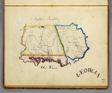
Full Title
Georgia.
List No
2501.015
Note
In outline color. The map includes West Florida, and extends from the Atlantic to the Mississippi River.
Author
Henshaw, Frances A.
Full Title
(Description of) Georgia.
List No
2501Q
Note
Text includes information on the state of Georgia, the Mississippi Territory, and West Florida.
Author
Mitchell, Samuel Augustus
Full Title
A New Map of Georgia. With its Roads & Distances. Published by Charles Desilver, No. 251 Market Street Philadelphia. Entered ... 1856 by Charles Desilver ... Pennsylvania.
List No
2514.022
Note
Full color map. Shows state capital, towns, railroads, canals, etc. With table of steam boat routes. Relief shown by hachures. Prime meridian is Washington.
Author
[Carey, Mathew, Lewis, Samuel]
Full Title
Georgia, from the latest Authorities. W. Barker, sculp. Engraved for Carey's American Edition of Guthrie's Geography improved.
List No
2542.016
Note
Uncolored.
Author
Marshall, John
Full Title
A Map of those parts of Virginia, North Carolina, South Carolina, & Georgia, which were the scenes of the most important Operations of the Southern Armies. Compiled by S. Lewis. Engraved for the Life of Washington. Plate VIII. Engraved by Francis Shallus. Published by C.P. Wayne. Philadelphia. (1807)
List No
2559.008
Note
Engraved. Folded map. Relief shown by hachures.
Author
Tanner, Henry S.
Full Title
Georgia and Alabama By H.S. Tanner. Published by H.S. Tanner, Philadelphia. Engraved by H.S. Tanner & Assistants. Entered ... 20th day of August 1823, by H.S. Tanner... Pennsylvania. American Atlas.
List No
2589.034
Note
In full color by county. Trimmed close at bottom of map.
Author
Tanner, Henry S.
Full Title
Georgia and Alabama By H.S. Tanner. Improved to 1825. Published by H.S. Tanner, Philadelphia. Engraved by H.S. Tanner & Assistants. Entered ... 20th day of August 1823, by H.S. Tanner... Pennsylvania. American Atlas.
List No
2593.031
Note
In full color by county.
Author
[Malte-Brun, Conrad, 1775-1826, Lapie, Pierre]
Full Title
Asie Mineure, Armenie, Caucase, Syrie, etc.
List No
2631.015
Note
Prime meridian is Lutece.
Author
[Malte-Brun, Conrad, 1775-1826, Lapie, Pierre]
Full Title
Russie d'Europe.
List No
2631.055
Note
Prime meridian is Paris.
Author
[Malte-Brun, Conrad, 1775-1826, Lapie, Pierre]
Full Title
Partie Meridionale de la Russie d'Europe.
List No
2631.057
Note
Prime meridian is Paris.
Author
Bradford, Thomas G.
Full Title
North Carolina, South Carolina and Georgia. (to accompany) A Comprehensive Atlas, Geographical, Historical & Commercial. By T.G. Bradford. William D. Ticknor, Boston. Wiley & Long, New-York. Entered ... 1835, by Thos. G. Bradford ... Massachusetts.
List No
2643.041
Note
Outline color map by administrative boundaries. Shows cities and towns, roads, railroads, rivers, canals, mountains, etc. Includes explanation. Relief shown by hachures. Prime meridians are Washington and Greenwich.
Author
Bradford, Thomas G.
Full Title
Georgia. (to accompany) A Comprehensive Atlas, Geographical, Historical & Commercial. By T.G. Bradford. William D. Ticknor, Boston. Wiley & Long, New-York. Entered ... 1835, by Thos. G. Bradford ... Massachusetts.
List No
2643.042
Note
Outline color map by administrative boundaries. Shows cities and towns, canals, roads, rivers, mountains, etc. Includes explanation. Relief shown pictorially. Prime meridians are Washington and Greenwich.
Author
Bachmann, John
Full Title
(Covers to) Panorama of the Seat of War. Birds Eye View Of North And South Carolina And Part Of Georgia. John Bachmann, Publisher, 115 & 117 Nassau St., New York. Entered ... 1861 by John Bachmann ... New York. Drawn from Nature and Lith. by John Bachmann.
List No
2664A
Author
Bachmann, John
Full Title
Panorama of the Seat of War. Birds Eye View Of North And South Carolina And Part Of Georgia. John Bachmann, Publisher, 115 & 117 Nassau St., New York. Entered ... 1861 by John Bachmann ... New York. Drawn from Nature and Lith. by John Bachmann.
List No
2664.001
Note
Shows shelling of Ft. Hatteras. Stephenson shows an earlier issue (304.5) that does not have Bachmann's name as publisher, nor the phrase "drawn from nature and lith. by John Bachmann." Full color. Bound in black leather covers 38x30 with "North & South Carolina, Part of Georgia. G.G.W." stamped in gold.
Author
Bachmann, John
Full Title
(Covers to) Panorama of the Seat of War. Birds Eye View Of Florida And Part Of Georgia And Alabama. John Bachmann, Publisher, 115 & 117 Nassau St., New York. Entered ... 1861 by John Bachmann ... New York. Drawn from Nature and Lith. by John Bachmann.
List No
2665A
Author
Bachmann, John
Full Title
Panorama of the Seat of War. Birds Eye View Of Florida And Part Of Georgia And Alabama. John Bachmann, Publisher, 115 & 117 Nassau St., New York. Entered ... 1861 by John Bachmann ... New York. Drawn from Nature and Lith. by John Bachmann.
List No
2665.001
Note
Shows entire Florida Peninsula. See Stephenson page 15 for a general discussion of Bachmann's civil war views. In addition to the six panoramas of the seat of war, Bachmann did a view of Richmond (Stephenson 621, illustrated p271), and of the junction of the Ohio and Mississippi Rivers (Stephenson 1.5) - which may be similar to the Kentucky - Tennessee Seat of War view, at least in terms of vantage point. Full color. Bound in black leather covers 38x30 with "Florida & Part Of Georgia & Alabama. G.G.W." stamped in gold.
Author
Finley, Anthony
Full Title
Georgia. Young & Delleker Sc. Published by A. Finley Philada.
List No
2680.024
Author
[Gray, Ormando Willis, Lloyd, H.H., Walling, H. F.]
Full Title
Atlas of the United States. Florida, Georgia, and South Carolina. (Published by Stedman, Brown & Lyon, Cincinnati. 1872. Entered ... 1872, by H.F. Walling, and O.W. Gray, and H.H. Lloyd & Co. ... Washington)
List No
2710.035
Note
Hand col. lithographed map. Counties in full color.
Author
Carey, Mathew
Full Title
The State of Georgia. Gridley sc.
List No
2721.025
Note
Counties and regions in outline color with swamps noted. Relief shown by hachures. Prime meridians London and Philadelphia.
Author
Lange, Henry, 1821-1893.
Full Title
Alabama, Georgia, Sud Carolina und Florida. H. Lange's Atlas v. Nord Amerika Blatt V. Braunschweig: Verlag v. George Westermann. Lith. Anst. von L. Kraatz in Berlin.
List No
2743.005
Note
Engraved map. Borders hand col. Shows roads, railroads, swamps, etc. Relief shown by hachures.
Author
Tanner, Henry S.
Full Title
Georgia And Alabama By H.S. Tanner. Improved To 1825. American Atlas. Entered ... 20th day of August 1823, by H.S. Tanner ... Pennsylvania. Published by H.S. Tanner, Philadelphia. Engraved by H.S. Tanner & Assistants.
List No
2755.015
Note
In full color by county.
Author
[Stieler, Adolf, Petermann, A.]
Full Title
Stieler's Hand-Atlas No. 55. Ost-Europe in 6 Blatten, Enthaltend: Norwegen, Schweden, Russland, Kaukasten, und die Turkei. Blatt 6. Sud-Russland & Kaukasien. (insets) Ararat. Tiflis.
List No
2761.062
Author
Johnston, W. & A.K.
Full Title
Turkey in Asia (Asia Minor) and Transcaucasia. Keith Johnston's General Atlas. Oct. 1911. Engraved, Printed, and Published by W. & A.K. Johnston, Limited, Edinburgh & London.
List No
2763.035
Note
Countries outlined in color. Relief shown by hachures. Five scales.
Author
Tanner, Henry S.
Full Title
Georgia and Alabama. (engraved by) J. Knight. Sc. (to accompany) A New Pocket Atlas of the United States With The Roads and Distances, Designed For the Use of Travelers. By H.S. Tanner. Philadelphia: Published by the Author. 1828. (on verso) ...on the seventeenth day of November ... 1828, Henry S. Tanner ... hath deposited ... a book ... Pennsylvania.
List No
2782.012
Note
Outline colored map. Prime meridian is Washington, D.C. Rare. Same maps used in Darby's View of U.S. Although this appears in Tanner's catalogues for several years after 1828, it must not have sold well, as few copies have survived. Bound with half leather and paper covered boards. "Pocket Atlas" embossed on spine.
Author
Rand McNally and Company
Full Title
Georgia.
List No
2790.103
Author
Rand McNally and Company
Full Title
Relief Map of Georgia.
List No
2790.105
Author
Melish, John
Full Title
Map of the Country belonging to the Cherokee and Creek Indians From the Original Drawing in the War Department. J. Melish del. (1824)
List No
2803.020
Note
Engraved. Meridians Washington and London. Bound with sheet inverted. Shows routes taken by General Jackson's Army to the Creek Nation and by General Cock's Army.
Author
Cram, George Franklin
Full Title
Georgia.
List No
2809.043
Note
Locations of banking towns shown by red circles. Railroads are indicated by numbers and colors and patterns, and each railroad has the same number and color and pattern in every state through which it passes. All railroads on each map are in a list keyed to the map. Border of map has a table of contents for the atlas. Relief shown by hachures. Prime meridians Washington D.C. and Greenwich.
Author
Rand McNally and Company
Full Title
(Text Page) Rand, McNally Co.'s South Carolina. Rand, McNally Co.'s Georgia.
List No
2844BB
Note
Tables of railroads and geographical features keyed to map.
Author
Rand McNally and Company
Full Title
Rand, McNally & Co.'s Georgia.
List No
2844.034
Note
Relief shown by hachures. Railroads and chief cities listed and keyed to map.
Author
Rand McNally and Company
Full Title
(Text Page) Rand, McNally Co.'s Georgia.
List No
2844BC
Note
Tables of geographical features keyed to map.
Author
Rand McNally and Company
Full Title
(Text Page) Rand, McNally Co.'s Georgia.
List No
2844BD
Note
Tables of geographical features keyed to map.
Author
Rand McNally and Company
Full Title
(Text Page) Rand, McNally Co.'s Georgia. Rand, McNally Co.'s Florida.
List No
2844BE
Note
Tables of railroads and geographical features keyed to map.
Author
Carey, Mathew
Full Title
Georgia from the latest Authorities. W. Barker, sculp. Engraved for Carey's American Edition of Guthrie's Geography improved.
List No
2862.039
Note
Uncolored.
Author
Greenleaf, Jeremiah
Full Title
Georgia.
List No
2866.052
Note
Full color by county. Engraved. Relief shown by hachures. Meridians Greenwich and Washington.
Author
Johnson, A.J.
Full Title
Johnson's Georgia And Alabama By Johnson & Browning. No. 28-29.
List No
2905.018
Note
In full color by county.
Full Title
(Map of Alabama, Georgia and part of Florida. Raleigh: Branson, Farrar & Co., Publishers. Biblical Recorder Print. 1863)
List No
2915.004
Note
Black and white map. Shows state boundaries, settlements, railroads, etc.
Author
Carey, Mathew
Full Title
Georgia from the latest Authorities. W. Barker, sculp. Engraved for Carey's American Edition of Guthrie's Geography improved.
List No
2931.040
Note
Uncolored.
Author
Fullarton, A. & Co.
Full Title
United States North America According to Calvin, Smith & Tanner. By G.H. Swanston Edinr. The South Eastern States Comprising Mississippi, Alabama, Tennessee, Georgia, Nth. & Sth. Carolina, and part of Florida, Virginia & Kentucky. LVIII. Engd. by G.H. Swanston Edinburgh. A. Fullarton & Co. Edinburgh, London & Dublin.
List No
3007.059
Note
In full color by state.
Author
Bolitho, Edwin
Full Title
Map of the Dahlonega Distrtict, GA. (to accompany) Pocket Mining Atlas. Compiled From The Latest Official Surveys, And The Most Authentic Sources. Edwin Bolitho, Engineering and Mining Journal, New York, 1880. Price, $1.00 per copy. (on following page) Entered ... 1880 ... Washington, D.C., by Trask & Francis, Bankers ... 70 Broadway, New York ...
List No
3054.006
Note
Full color map. Showing districts and counties.
|