|
Author
Mitchell, Samuel Augustus
Full Title
(Covers to) Map Of The States Of North Carolina South Carolina and Georgia. Philadelphia: Published by S. Augustus Mitchell. 1836. Sold By Mitchell & Hinman No. 6 North Fifth Street. Entered ... 1835, by S. Augustus Mitchell ... Pennsylvania. Engraved by J.H. Young. (inset) Vicinity Of Charleston.
List No
15231.001
Note
First issued in Finley's American Atlas 1826, then reissued by Mitchell in 1831, this 1841 edition continues with an inset of Charleston and tables of stage and steamboat routes . Folded into dark brown leather covers 13.5x8 with "Mitchell's Map Of The Carolina's & Georgia" and a decorative border in gilt. Full color. Printed date of 1841 appears to be an erasure of the prior edition 1836 date.
Author
Mitchell, Samuel Augustus
Full Title
Map Of The States Of North Carolina South Carolina and Georgia. Philadelphia: Published by S. Augustus Mitchell. 1841. Sold By Mitchell & Hinman No. 6 North Fifth Street. Entered ... 1835, by S. Augustus Mitchell ... Pennsylvania. Engraved by J.H. Young. (inset) Vicinity Of Charleston.
List No
15231.002
Note
First issued in Finley's American Atlas 1826, then reissued by Mitchell in 1831, this 1841 edition continues with an inset of Charleston and tables of stage and steamboat routes . Folded into dark brown leather covers 13.5x8 with "Mitchell's Map Of The Carolina's & Georgia" and a decorative border in gilt. Full color. Printed date of 1841 appears to be an erasure of the prior edition 1836 date.
Author
[Fisher, Joseph R., Planters Peanuts (Firm)]
Full Title
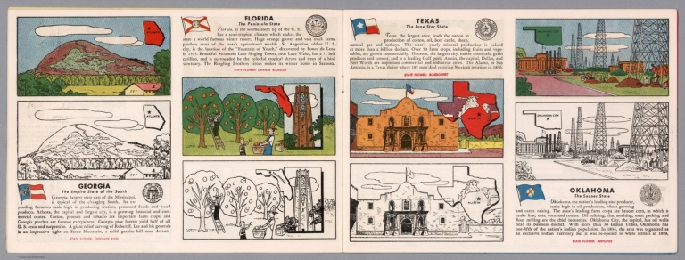
Georgia : The empire state of the south -- Florida : The peninsula state -- Texas : The lone star state -- Oklahoma : The sooner state.
List No
14374.007
Note
Four views, representing Georgia, Florida, Texas and Oklahoma. Views show examples of the landscape and natural resources. Each view includes an inset map of the state, which marks the location of the capital city with a star. Accompanied by descriptive text, the state flags, seals and flowers: Cherokee rose, orange blossom, bluebonnet and mistletoe, respectively. The view of each state appears both in color (on top) and in black and white (bottom), the latter inviting coloration. Together, views are 18 x 52 cm, on two sheets 20 x 54 cm.
Author
[Tomson, K., Klement'ev, N. F.]
Full Title
(Title Page to) Podrobnaia spravochnaia knizhka g. Tiflisa. Tiporafiia I Martirosiantsa Orbel. Ul. D. No. 5. 1884. (Map) Plan' goroda Tiflisa s Okrestnostyami, sb prilozheniem’ spravochnogo ukazatelja. Sostavlen’ po novoyima svedeniiam' i izdan' po porucheniyu Tiflisskoy gorodskoy dumy N. F. Klement'evym'. G. Tiflis’ 1884 g. Ispravlen po 1oe. 1887 goda. Khudozh-litogr. K. Tomsona.
List No
13677.002
Author
شكوفه مقبل [Şukufe Mukbil]
Full Title
(The Caucasus with railroads)
List No
10992.021
Note
Dimensions are sheet size.
Author
Waldmire, Robert, 1945-2009
Full Title
Athens, and the University of Georgia among other thing ... Slice o' life poster of another American town ... By: Android, number 345-36-5919.
List No
13634.000
Author
Cram, George Franklin, 1841-1928
Full Title
Cram's railroad and county map of Georgia. Published by Geo. F. Cram, 262-264, Wabash, Ave. Chicago, Ills. 1882
List No
14250.042
Note
Map of Georgia, showing railroads, county boundaries, cities and towns, drainage and coastline. Political boundary lines in color. Includes a bar scale and a scale statement: Scale 19 miles to an inch. With index numbers along the perimeter, and decorative border. 47 x 37 cm, on sheet 58 x 45 cm.
Author
Kandelaki, A.V.
Full Title
добро пожаловать в грузию (Welcome to Georgia).
List No
10702.003
Note
Map is dated 1977. Text is in Russian.
Author
[Mercator, Gerhard, 1512-1594, Hondius, Jodocus, 1563-1612, Hondius, Hendrik, 1597-1651]
Full Title
Virginiae Item et Floridae Americae Provinciarum, nova Descriptio.
List No
10534.359
Author
[Mercator, Gerhard, 1512-1594, Hondius, Jodocus, 1563-1612]
Full Title
Virginiae Item et Floridae Americae Provinciarum, nova Descriptio.
List No
10501.508
Author
[Chatelain Henri, 1684-1743, Gueudeville, Nicolas]
Full Title
Vue et description des principales villes de l'Armenie et de la Georgie. Tom. V. No. 11. Pag. 28. (to accompany) Atlas Historique ... Tom. V. A Amsterdam, chez L'Honore & Chatelain Libraires. M DCC XIX (1719).
List No
13272.466
Note
Engraved folded plate of views and description of the major cities of Armenia and Georgia, with the costumes of women and Priests and religious figures of the region.
Author
[Ogilby, John, 1600-1676, Montanus, Arnoldus, 1625?-1683, Moxon, James]
Full Title
A New Description of Carolina by Order of the Lords Proprietors.
List No
12241.044
Note
North to the right. Foldout.
Author
[Early, Eleazer, Sturges, Daniel]
Full Title
Map Of The State of Georgia Prepared from actual Surveys and other Documents for Eleazer Early By Daniel Sturges. Entered According to Act of Congress by Eleazer Early Proprietor. Engraved by Saml. Harrison 1818. Published & Sold By Eleazer Early Savannah Georgia and By John Melish & Samuel Harrison Philadelphia.
List No
4874.000
Note
Ristow mentions two editions with the same title, date and imprint, and with the later edition having "a number of changes and additions... in the southern Alabama portion of the map." We believe this copy is the first edition as we can detect no plate changes in the areas mentioned. This is the first large scale map of Georgia and it ranks in importance with the other large Southern State and Territory maps of the period: Wilson's South Carolina of 1822, Madison's Virginia of 1807 and 1818, Price and Strothers' North Carolina of 1808, and Vignoles' Florida of 1823. While it was undoubtedly the most accurate Georgia map when published, it quickly came under criticism by Tanner in his Geographical Memoir of 1823 for his American Atlas - he found the delineation of the Savannah River to be more correct in the Wilson 1822 Map of South Carolina. It has a lovely cartouche vignette, a table of distances, a statistical table, and "Remarks, Statistical and Geological." Streeter: "All in all an important and elaborate map of Georgia in the first part of the nineteenth century." Full color by county, without rollers.
Author
[Mitchell, John, Raynal, G.T., Zatta, Antonio]
Full Title
Parte Orientale della Florida, della Giorgia, e Carolina Meridionale. Fogl. XI.
List No
5007.013
Note
In outline color.
Author
Appleton, D. & Co.
Full Title
Map of Georgia. Copyright 1891 by Matthews-Northrup Co. ... Buffalo, New York. (inset) Map of Atlanta. (to accompany) The Library Atlas Of Modern Geography ... New York, D. Appleton And Company 1892. (on upper margin) Georgia. 60.
List No
0026.155
Note
Color map. Shows county boundaries and county seat, capital, railways, roads, etc. "Size of type indicates importance of the places". Includes notes. Relief shown by hachures. Prime meridians are Greenwich and Washington.
Author
Arbuckle Bros.
Full Title
Maryland, Georgia, Illinois, Pennsylvania. Copyright 1889 Arbuckle Bros. N.Y.
List No
0027.006
Note
Sheet with maps of four states in full color. On the card for Illinois, it is noted that the inhabitants of Chicago are "probably the most energetic people in the world." Pennsylvania is noted for being second only to New York in manufacturing. Each card measures 7.5 x 12.5 cm.
Author
Lewis, Samuel
Full Title
Georgia. Drawn by S. Lewis. D. Fairman sc. (Boston: Published by Thomas & Andrews. 1812)
List No
0028.045
Note
Engraved map, uncolored. Relief shown by hachures. Prime meridians: Philadelphia and London.
Author
Asher & Adams
Full Title
Asher & Adams' Georgia & Alabama. Entered according to Act of Congress in the year 1874 by Asher & Adams ... at Washington. (New York, 1874)
List No
0041.010
Note
Hand col. engraved map. Relief shown by hachures. Shows townships, distances along railroads, etc. Prime meridians: Greenwich and Washington.
Author
[Bartholomew, John, Black, Adam & Charles]
Full Title
Georgia & Florida. Published by A. & C. Black. Edinburgh. Printed in Colours by Schenck & Macfariane. Edinburgh. Drawn & Engraved by J. Bartholomew, Edinburgh.
List No
0073.014
Note
States outlined in color. Land tinted. Inset of Continuation of Florida.
Author
Bradford, Thomas G.
Full Title
Georgia. Entered ... 1838, by T.G. Bradford ... Massachusetts. Engraved by G.W. Boynton.
List No
0089.030
Note
In full color.
Full Title
Carte geographique, statistique et historique de la Georgie. Georgie. Fonderie et Imprimerie de J. Carez. (1825)
List No
0102.025
Note
Hand colored engraved map. Relief shown by hachures. Text and tables at sides and bottom. Prime meridians: Washington and Paris.
Author
Burr, David H., 1803-1875
Full Title
Map of Georgia & Alabama Exhibiting the Post Offices, Post Roads, Canals, Rail Roads, &c. By David H. Burr. (Late Topographer to the Post Office.) Geographer to the House of Representatives of the U.S. John Arrowsmith. Entered ... July 10th, 1839, by David H. Burr ... District of Columbia.
List No
0104.007
Note
In full color by county. Postal routes by coach, stage, sulkey, cross, rail roads and canals shown. In 8 sections mounted on linen. Label on back states "No. 7. Georgia, Alabama."
Author
[Carey, H. C., Lea, I.]
Full Title
Geographical, Historical, And Statistical Map Of Georgia. Georgia. No. 25. Drawn by F. Lucas Jr. J. Yeager Sculp.
List No
0122.020
Note
In full color by county or region surrounded by text.
Author
Colton, G.W.
Full Title
The City Of Savannah Georgia. (with) The City of Charleston South Carolina. Published By J.H. Colton & Co. No. 172 William St. New York. Entered ... 1855 by J.H. Colton & Co. ... New York. No. 28.
List No
0149.034
Note
In full color. The Savannah map includes a history of the city and references to the numbered squares and wards. The Charleston map is also numbered but lacks a key.
Author
Colton, G.W.
Full Title
Georgia. Published By J.H. Colton & Co. No. 172 William St. New York. Entered ... 1855 by J.H. Colton & Co. ... New York. No. 29.
List No
0149.035
Note
In full color by county.
Author
Colton, G.W.
Full Title
Colton's Georgia. Published By J. H. Colton. No. 172 William St. New York.
List No
0151.041
Note
Map showing the county boundaries in color. Prime meridians are Greenwich and Washington D.C.
Author
Colton, G.W.
Full Title
The City of Savannah, Georgia. The City of Charleston, South Carolina. Published By J. H. Colton. No. 172 William St. New York.
List No
0152.039
Note
The plans of Charleston & Savannah are upon the same scale.
Author
Colton, G.W.
Full Title
Colton's Georgia. Published By G. W & C. B. Colton & Co. No. 172 William St. New York.
List No
0152.040
Note
Prime meridians are Washington D.C. and Greenwich.
Author
Cram, George Franklin
Full Title
New Rail Road and County Map of Alabama, Georgia, Sth. Carolina & Northern Florida.
List No
0210.031
Note
Prime meridians Greenwich and Washington.
Author
Cram, George Franklin
Full Title
Russia.
List No
0210.076
Note
Prime meridians Greenwich and Washington.
Full Title
The state of Georgia. Gridley sc. (Philadelphia: Robert DeSilver, 1827)
List No
0239.000
Note
Updated from M. Carey's 1818 edition General Atlas. Many changes: coastline, rivers, counties, towns. Map is missing a piece in the upper right corner -- supplied in facsimile. Outline color by county. Relief shown by hachures. "20." Prime meridians: Philadelphia and London.
Author
Finley, Anthony
Full Title
Map Of North and South Carolina And Georgia, Constructed from the Latest Authorities. 1825. Copyright secured. J.H. Young Sculp. Published by A. Finley Philada. 1824.
List No
0278.008
Note
In full color by county. Topographical table includes population by state from the 1820 census for "White, Free Black & Slave Population".
Author
Finley, Anthony
Full Title
Map of North and South Carolina and Georgia, Constructed from the Latest Authorities, 1827.
List No
0279.012
Author
Finley, Anthony
Full Title
Map of North and South Carolina, and Georgia, Constructed from the Latest Authorities. 1827. Copyright secured. Published by A. Finley, Philada. 1827. J.H. Young Sculp.
List No
0280.008
Note
Relief shown by hachures. Prime meridian Washington. Statistical table for state.
Author
Finley, Anthony
Full Title
Georgia. Young & Delleker Sc. Published by A. Finley, Philada. (to accompany) A New General Atlas Comprising a Complete Set of Maps, representing the Grand Divisions Of The Globe ... Philadelphia: Published by Anthony Finley. 1827.
List No
0282.025
Note
Full color map on sheet 35x27. Relief shown pictorially. Prime meridians are Washington and Greenwich. Shows counties, major cities, roads and rivers.
Author
Finley, Anthony
Full Title
Georgia. Published by A. Finley Philada. Young & Delleker Sc.
List No
0285.021
Note
Full color by county.
Author
[Bowen, Emanuel, Gibson, John]
Full Title
Carolina And Georgia. (to accompany) Atlas Minimus or a New Set of Pocket Maps of the Several Empires, Kingdoms and States of the Known World, with Historical Extracts relative to each. Drawn and Engraved by J. Gibson from the Best Authorities, Revis'd, Corrected and Improv'd by Eman: Bowen Geographer to His Majesty.
List No
0300.048
Note
First edition. The "Historical Extracts" are short bits of text printed on the maps giving relevant geographical information. A revised edition was published in London in 1792. In 1759, another edition was published adding separate geographical descriptions and correcting some of the maps (see our copy). The Philadelphia 1798 edition by Mathew Carey incorporates the 1759 edition text word for word (excepting the maps of United States which Carey omits in favor of his pocket atlas of the U.S.). Gibson and Bowen made the four sheet map of North America (Stevens 49), and Gibson made the four sheet map of America (Stevens 3).
Author
Gray, O.W.
Full Title
Gray's Atlas Map of Georgia.
List No
0310.051
Author
[Gray, Frank A., Gray, O.W.]
Full Title
Gray's New Map of Georgia by Frank A. Gray. Copyright 1877 by O.W. Gray & Son. (insets) Entrance to Savannah River. Savannah.
List No
0312.026
Full Title
N. & S. Carolina, Georgia & Florida. J.H. Young Sc. (Philadelphia: John Grigg, No. 9 North Fourth Street. 1830)
List No
0315.007
Note
Engraved map. Full hand color. Relief shown pictorially. Prime meridians: Greenwich and Washington.
Author
Johnson, A.J.
Full Title
Johnson's Georgia And Alabama Published By Johnson and Ward.
List No
0352.029
Note
Full color by county, with heavy outlines around the state. Relief shown by hachures. Prime meridians are Greenwich and Washington D.C.
Author
Johnson, A.J.
Full Title
Johnson's Georgia and Alabama. Entered ... 1863.
List No
0358.035
Author
Johnston, Alexander Keith
Full Title
Turkey in Asia (Asia Minor) and Transcaucasia. By Keith Johnston, F.R.S.E. Keith Johnston's General Atlas. Engraved, Printed, and Published by W. & A.K. Johnston, Edinburgh & London.
List No
0377.034
Note
Countries outlined in color. Relief shown by hachures. Five scales.
Author
Leahy, J.F.
Full Title
(Index Page to) Leahy's Hotel Guide and Railway Distance Maps. Georgia.
List No
0425.024
Note
Alphabetical index list of the Hotels of the town with the number of rooms of each, their rates per day and the population of the town. Includes population of the state.
Author
Leahy, J.F.
Full Title
Leahy's Hotel Guide and Railway Distance Map of the State of Georgia. Published by American Hotel Register Company. Leahy Build., 228-234 W. Ontario St., Chicago, Ill. Copyrighted by J.F. Leahy, Jan., 1934.
List No
0425.025
Note
Map printed without color. Includes name of the railroad entering the town, and distance between towns. With Explanation of abbreviation of the railroad of the state.
Author
Marshall, John
Full Title
Theatre des Operations les plus importantes de l'Armee du Sud, dans la Virginie, dans les deux Carolines, et dans la Georgie. (1807)
List No
0462.011
Note
Engraved. Folded map. Relief shown by hachures.
Author
[Lawrence, Martin, Washington, George]
Full Title
North Carolina, south Carolina, and Georgia, showing in red the places visited by George Washington; the insert map gives the rout of his whole southern tour in 1791.
List No
0465.038
Note
Color map. Showing Washington's headquarters, battlefield, capital of the United States, locality known and approximate.
Author
Mitchell, Samuel Augustus
Full Title
(Covers to) Map Of The States Of North Carolina South Carolina and Georgia. Philadelphia: Published by S. Augustus Mitchell. 1836. Sold By Mitchell & Hinman No. 6 North Fifth Street. Entered ... 1835, by S. Augustus Mitchell ... Pennsylvania. Engraved by J.H. Young. (inset) Vicinity Of Charleston.
List No
0516.001
Note
First issued in Finley's American Atlas 1826, then reissued by Mitchell in 1831, this 1836 edition adds an inset of Charleston and tables of stage and steamboat routes . Folded into dark green leather covers 13.5x8 with "Mitchell's Map Of The Carolina's & Georgia" and a decorative border in gilt. Full color.
Author
Mitchell, Samuel Augustus
Full Title
Map Of The States Of North Carolina South Carolina and Georgia. Philadelphia: Published by S. Augustus Mitchell. 1836. Sold By Mitchell & Hinman No. 6 North Fifth Street. Entered ... 1835, by S. Augustus Mitchell ... Pennsylvania. Engraved by J.H. Young. (inset) Vicinity Of Charleston.
List No
0516.002
Note
First issued in Finley's American Atlas 1826, then reissued by Mitchell in 1831, this 1836 edition adds an inset of Charleston and tables of stage and steamboat routes . Folded into dark green leather covers 13.5x8 with "Mitchell's Map Of The Carolina's & Georgia" and a decorative border in gilt. Full color.
Author
Johnson, A.J.
Full Title
Johnson's Georgia And Alabama Published By Johnson and Ward.
List No
0535.028
Note
In full color by county. Relief shown by hachures. Meridians Greenwich and Washington D.C.
|