|
REFINE
Browse All : Images of Florida and Georgia and Alabama
1-15 of 15
Author
Cram, George Franklin
Full Title
New Rail Road and County Map of Alabama, Georgia, Sth. Carolina & Northern Florida.
List No
0210.031
Note
Prime meridians Greenwich and Washington.
Author
[Colton, G.W., Fisher, Richard Swainson]
Full Title
Georgia, Alabama, and Florida. (inset) Florida Keys.
List No
1690.084
Author
[Julius Bien & Co., United States. War Department]
Full Title
General topographical map. Sheet XII. Julius Bien & Co., Lith., N.Y. (1891-1895)
List No
1780.150
Note
Col. map. Shows settlements, railroads, roads, etc.
Author
[Jones, C.H., Hamilton, T.H., Williams, J.David]
Full Title
Map of South Carolina, Georgia, Florida, Alabama, Mississippi, and Louisiana.
List No
2307.021
Note
Relief shown in hachures.
Author
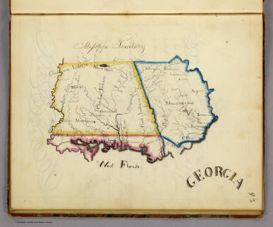
Henshaw, Frances A.
Full Title
Georgia.
List No
2501.015
Note
In outline color. The map includes West Florida, and extends from the Atlantic to the Mississippi River.
Author
Henshaw, Frances A.
Full Title
(Description of) Georgia.
List No
2501Q
Note
Text includes information on the state of Georgia, the Mississippi Territory, and West Florida.
Author
Bachmann, John
Full Title
(Covers to) Panorama of the Seat of War. Birds Eye View Of Florida And Part Of Georgia And Alabama. John Bachmann, Publisher, 115 & 117 Nassau St., New York. Entered ... 1861 by John Bachmann ... New York. Drawn from Nature and Lith. by John Bachmann.
List No
2665A
Author
Bachmann, John
Full Title
Panorama of the Seat of War. Birds Eye View Of Florida And Part Of Georgia And Alabama. John Bachmann, Publisher, 115 & 117 Nassau St., New York. Entered ... 1861 by John Bachmann ... New York. Drawn from Nature and Lith. by John Bachmann.
List No
2665.001
Note
Shows entire Florida Peninsula. See Stephenson page 15 for a general discussion of Bachmann's civil war views. In addition to the six panoramas of the seat of war, Bachmann did a view of Richmond (Stephenson 621, illustrated p271), and of the junction of the Ohio and Mississippi Rivers (Stephenson 1.5) - which may be similar to the Kentucky - Tennessee Seat of War view, at least in terms of vantage point. Full color. Bound in black leather covers 38x30 with "Florida & Part Of Georgia & Alabama. G.G.W." stamped in gold.
Author
Lange, Henry, 1821-1893.
Full Title
Alabama, Georgia, Sud Carolina und Florida. H. Lange's Atlas v. Nord Amerika Blatt V. Braunschweig: Verlag v. George Westermann. Lith. Anst. von L. Kraatz in Berlin.
List No
2743.005
Note
Engraved map. Borders hand col. Shows roads, railroads, swamps, etc. Relief shown by hachures.
Full Title
(Map of Alabama, Georgia and part of Florida. Raleigh: Branson, Farrar & Co., Publishers. Biblical Recorder Print. 1863)
List No
2915.004
Note
Black and white map. Shows state boundaries, settlements, railroads, etc.
Author
Smith, J. Calvin
Full Title
(Mississippi, Alabama, Florida, Georgia).
List No
3471.014
Note
Estimated Date. Part of a sixteen piece map combined digitally as a composite in final map of series.
Author
[Johnston, Alexander Keith, 1804-1871, Rogers, Henry Darwin]
Full Title
States Of South Carolina, Georgia, Alabama, And Florida. By Prof. H.D. Rogers & A. Keith Johnston, F.R.S.E. Entered in Sta. Hall. London ... & according to an act of Congress ... 1857, by H.D. Rogers ... Massachusetts. London, John Murray, Albemarle Street, Edinburgh, W. & A.K. Johnston. Engraved by W. & A.K. Johnston, Edinburgh.
List No
3825.016
Note
States and counties shown in outline printed color. Bahamas shown off the Florida coast.
Author
Cram, George Franklin
Full Title
New Rail Road and County Map of Alabama, Georgia, Sth. Carolina & Northern Florida.
List No
4558.031
Author
Rand McNally and Company
Full Title
(Covers to) Rand, McNally & Co.'s New Shippers' Railroad Map of the United States. Scale: 8 miles to one inch. Showing all railroads, each in a separate color, and all railroad stations in large, plain type. This is the Savannah section, only, of the above-named map. (Above the neatline) Copyright, 1890 by Rand, McNally & Co.
List No
5802G
Note
This is the Savannah section of the larger map.
Author
Rand McNally and Company
Full Title
Rand, McNally & Co.'s New Shippers' Railroad Map of the United States. Scale: 8 miles to one inch. Showing all railroads, each in a separate color, and all railroad stations in large, plain type. This is the Savannah section, only, of the above-named map. (Above the neatline) Copyright, 1890 by Rand, McNally & Co.
List No
5802.007
Note
This is the Savannah section of the larger map.
1-15 of 15
|