|
REFINE
Browse All : Images of England from 1790
1-33 of 33
Author
Kitchin, Thomas
Full Title
A compleat map of the British Isles, or Great Britain and Ireland with their respective roads and divisions. (By Thomas Kitchin). London: published by Robt. Sayer, no. 53 Fleet Street, as the Act directs, 1st Jany. 1788.
List No
0411.007
Note
Engraved map with counties in outline color. Relief shown pictorially. (W 12--E 2/N 61--N 49)
Author
Rocque, John
Full Title
England and Wales, drawn from the most accurate surveys containing all the cities, boroughs, market towns & villages; (Northern section). In which are included all the improvements and observations both astronomical and topographical, which have been made by members of the Royal Society & others. Down to the present year, the whole corected & improv'd by John Rocque, Chorographer to his Majesty. (London, printed for Robt. Sayer, Map & Printseller at the Golden Buck in Fleet Street, 1790?)
List No
0411.008
Note
Engraved map printed on 2 sheets comprising the northern half of the 4-sheet map. Counties in outline color. Shows forested areas, classified roads with distances, etc. Relief shown pictorially. Has ornamental cartouche and drawings of ships. David Rumsey Collection sheets mounted together as one sheet.
Author
Rocque, John
Full Title
(England and Wales, drawn from the most accurate surveys containing all the cities, boroughs, market towns & villages; Southern section. In which are included all the improvements and observations both astronomical and topographical, which have been made by members of the Royal Society & others. Down to the present year, the whole corected & improv'd by John Rocque, Chorographer to his Majesty). London, printed for Robt. Sayer, Map & Printseller at the Golden Buck in Fleet Street, (1790?)
List No
0411.009
Note
Engraved map printed on 2 sheets comprising the southern half of the 4-sheet map. Counties in outline color. Shows forested areas, classified roads with distances, etc. Relief shown pictorially. Includes inset map of the Isles of Scilly and drawings of ships. David Rumsey Collection sheets mounted together as one sheet.
Author
Rocque, John
Full Title
(Composite of) England and Wales, drawn from the most accurate surveys containing all the cities, boroughs, market towns & villages; in which are included all the improvements and observations both astronomical and topographical, which have been made by members of the Royal Society & others. Down to the present year, the whole corected & improv'd by John Rocque, Chorographer to his Majesty. London, printed for Robt. Sayer, Map & Printseller at the Golden Buck in Fleet Street, (1790?)
List No
0411.010
Note
Engraved map printed on 4 sheets comprising. Counties in outline color. Shows forested areas, classified roads with distances, etc. Relief shown pictorially. Includes inset map of the Isles of Scilly and drawings of ships. David Rumsey Collection sheets mounted together as 2 sheets. (W 7 00--E 2 30/N 56 20--N 49 30)
Author
Schreiber, Johann George, 1676-1750
Full Title
Gros Britanni oder Engelland Schottland und Irrland : verfertiget in Leipzig von Joh. George Schreiber. (inset) Orcades Insulae. (to accompany) Atlas selectus von allen Konigreichen und Landern der Welt ...
List No
11208.018
Note
Hand colored map of Great Britain with inset. Includes title cartouche decorated with coat of arms, compass rose, explanatory text and and directory on the right of the map.
Author
Cary, John, ca. 1754-1835
Full Title
(Covers to) Cary's Survey of the High Roads From London to ... On a Scale of one Inch to a Mile; wherein Every Gentleman's Seat, situate on, or seen from the Road, (however distant) are laid down, with the name of the Possessor; to which is added The Number of Inns on each separate route; also, the different Turnpike Gates, shewing The Connection which one trust has with another. London: Printed for J. Cary, Engraver & Map seller, the corner of Arundel Street, Strand. July 1st, 1790.
List No
2724A
Note
Quarter light brown leather binding with marbled green boards. Corners of light brown leather. Cary's High Roads printed in gilt on spine.
Author
Cary, John, ca. 1754-1835
Full Title
General Map (London Environs). Published by J. Cary, Strand, as the Act directs, July 1st, 1790.
List No
2724.001
Note
Shows routes detailed in atlas; it is a cartographic index to the atlas page numbers.
Author
Cary, John, ca. 1754-1835
Full Title
General Plan for Explaining the different Trusts of the Turnpike Gates in the Vicinity of the Metropolis. Published by J. Cary, July 1st. 1790.
List No
2724.002
Note
Shows the toll districts and gates and explains Sunday tickets.
Author
Cary, John, ca. 1754-1835
Full Title
Explanation, Advertisement, London to Hampton Court.
List No
2724.003
Note
Linear color maps showing features along the way. North arrow on each map.
Author
Cary, John, ca. 1754-1835
Full Title
Brentford to Bagshot, Virginia Water to Oakingham.
List No
2724.004
Note
Linear color maps showing features along the way. North arrow on each map.
Author
Cary, John, ca. 1754-1835
Full Title
Egham to Binfield, Hounslow to Windsor.
List No
2724.005
Note
Linear color maps showing features along the way. North arrow on each map.
Author
Cary, John, ca. 1754-1835
Full Title
Colnbrook to Maidenhead, London to High Wycombe.
List No
2724.006
Note
Linear color maps showing features along the way. North arrow on each map.
Author
Cary, John, ca. 1754-1835
Full Title
Uxbridge to Amersham.
List No
2724.007
Note
Linear color maps showing features along the way. North arrow on each map.
Author
Cary, John, ca. 1754-1835
Full Title
London to Tring.
List No
2724.008
Note
Linear color maps showing features along the way. North arrow on each map.
Author
Cary, John, ca. 1754-1835
Full Title
Watford to Rickmans Worth to Amersham, Watford to St. Albans.
List No
2724.009
Note
Linear color maps showing features along the way. North arrow on each map.
Author
Cary, John, ca. 1754-1835
Full Title
London to Highgate & Hampstead to Hendon, London to St. Albans.
List No
2724.010
Note
Linear color maps showing features along the way. North arrow on each map.
Author
Cary, John, ca. 1754-1835
Full Title
Chipping Barnet to Welwyn, London to Hertford.
List No
2724.011
Note
Linear color maps showing features along the way. North arrow on each map.
Author
Cary, John, ca. 1754-1835
Full Title
Hoddesdon to Ware, Potters Bar to Ware, London to Bishops Stortford.
List No
2724.012
Note
Linear color maps showing features along the way. North arrow on each map.
Author
Cary, John, ca. 1754-1835
Full Title
London to Chipping Ongar.
List No
2724.013
Note
Linear color maps showing features along the way. North arrow on each map.
Author
Cary, John, ca. 1754-1835
Full Title
Stratford to Chelmsford.
List No
2724.014
Note
Linear color maps showing features along the way. North arrow on each map.
Author
Cary, John, ca. 1754-1835
Full Title
London to Rochester.
List No
2724.015
Note
Linear color maps showing features along the way. North arrow on each map.
Author
Cary, John, ca. 1754-1835
Full Title
New Cross to Maidstone.
List No
2724.016
Note
Linear color maps showing features along the way. North arrow on each map.
Author
Cary, John, ca. 1754-1835
Full Title
Lewisham to Tunbridge Wells.
List No
2724.017
Note
Linear color maps showing features along the way. North arrow on each map.
Author
Cary, John, ca. 1754-1835
Full Title
London to East Grinsted.
List No
2724.018
Note
Linear color maps showing features along the way. North arrow on each map.
Author
Cary, John, ca. 1754-1835
Full Title
Newington to Ryegate.
List No
2724.019
Note
Linear color maps showing features along the way. North arrow on each map.
Author
Cary, John, ca. 1754-1835
Full Title
Tooting to Dorking.
List No
2724.020
Note
Linear color maps showing features along the way. North arrow on each map.
Author
Cary, John, ca. 1754-1835
Full Title
Leatherhead to Guildford, London to Guildford.
List No
2724.021
Note
Linear color maps showing features along the way. North arrow on each map.
Author
Cary, John, ca. 1754-1835
Full Title
Hampton Court to Staines.
List No
2724.022
Note
Linear color maps showing features along the way. North arrow on each map.
Author
Cary, John, ca. 1754-1835
Full Title
London to Richmond.
List No
2724.023
Note
Linear color maps showing features along the way. North arrow on each map.
Author
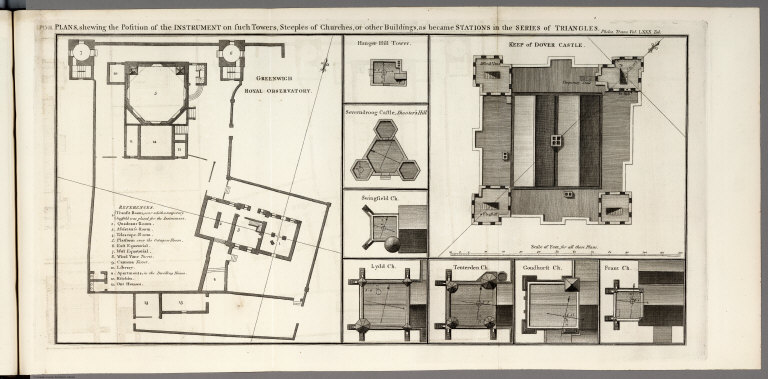
Roy, William
Full Title
Pl. VIII. Plans, showing the position of the instrument on such towers, steeples of churches, or other buildings, as became stations in series of triangles. Philos. Trans. Vol. LXXX. Tab. p. Basire, Sc. (to accompany) An account of the trigonometrical operation. From the Philosophical Transactions. (London: 1790).
List No
6876.016
Note
Uncolored maps folded on one page. Showing the position of triangles in each building. Includes references.
Author
Roy, William
Full Title
Pl. IX. Plan of the triangles whereby the distance between the Royal Observatories of Greenwich and Paris has been determined. Philos. Trans. Vol. LXXX. Tab. Basire, Sc. (to accompany) An account of the trigonometrical operation. From the Philosophical Transactions. (London: 1790).
List No
6876.017
Note
Uncolored map folded on one page. Relief shown by landform drawings and hachures. Prim meridian is Greenwich
Author
Roy, William
Full Title
Pl. X. For the figure of the earth, pole-star observations, differences of longitude and terrestrial refractions. Philos. Trans. Vol. LXXX. Basire, Sc. (to accompany) An account of the trigonometrical operation. From the Philosophical Transactions. (London: 1790).
List No
6876.018
Note
Uncolored map views on one page.
Author
Roy, William
Full Title
Pl. XI. For the improvement of the plan of London and its environs. Philos. Trans. Vol. LXXX. Basire, Sc. (to accompany) An account of the trigonometrical operation. From the Philosophical Transactions. (London: 1790).
List No
6876.019
Note
Uncolored folded map .
1-33 of 33
|