|
REFINE
Browse All : Images of Ecuador and Colombia
1-50 of 50
Author
Colton, G.W.
Full Title
Colton's Venezuela, United States of Colombia or New Granada and Ecuador. Published By G. W & C. B. Colton & Co. No. 172 William St. New York.
List No
0152.071
Note
Prime meridians are Washington D.C. and Greenwich.
Author
Pinkerton, John, 1758-1826
Full Title
New Granada. Drawn under the direction of Mr. Pinkerton by L. Hebert. Neele sculpt. 352 Strand. London: published 1st Septr. 1811 by Cadell & Davies, Strand & Longman, Hurst, Rees, Orme, & Brown, Pater Noster Row.
List No
0732.053
Note
Engraved map. Full hand col. Relief shown by hachures. Shows tribes, geographic notes, etc. Covers modern Colombia, Ecuador and Panama and portions of Venezuela, Peru and Brazil. "Pinkerton's modern atlas."
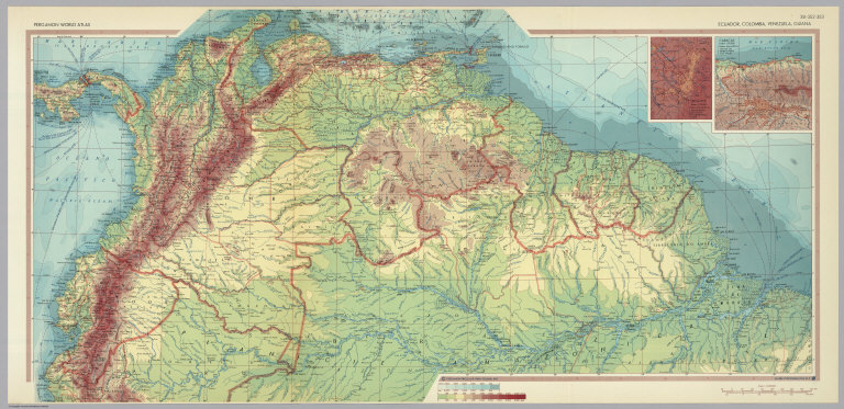
Author
Polish Army Topography Service
Full Title
Ecuador, Colombia, Venezuela, Guiana. (inset) Bogota. (inset) Caracas. Pergamon World Atlas. Pergamon Press, Ltd. & P.W.N. Poland 1967. Sluzba Topograficzna W.P.
List No
0737.219
Note
Detailed physical and political map.
Author
Stanford, Edward
Full Title
(Covers to) Colombia, Ecuador and Peru, also Panama. London: Edward Stanford, Ltd., 12, 13, & 14, Long Acre, W.C. London atlas series. Stanford's Geographical Establishment, London. (1922?)
List No
0947A
Note
Dark green cloth covered boards 18x12.5 with a yellow label reading: London Atlas Map of Colombia, Ecuador & Peru. London: Edward Stanford, Ltd. Cartographers to His Majesty the King, 12, 13, & 14, Long Acre, W.C.2.
Author
Stanford, Edward
Full Title
(Inside Covers to) Colombia, Ecuador and Peru, also Panama. London: Edward Stanford, Ltd., 12, 13, & 14, Long Acre, W.C. London atlas series. Stanford's Geographical Establishment, London. (1922?)
List No
0947B
Note
Inside front cover. List of "Stanford's atlases."
Author
Stanford, Edward
Full Title
Colombia, Ecuador and Peru, also Panama. (with Panama Canal Zone). (with) Galapagos Islands, Colon. London: Edward Stanford, Ltd., 12, 13, & 14, Long Acre, W.C. London atlas series. Stanford's Geographical Establishment, London. (1922?)
List No
0947.001
Note
Printed in full color by country. Map is dissected into 20 sections and mounted on linen. The covers are dark green cloth covered boards 18x12.5 with a yellow label reading: London Atlas Map of Colombia, Ecuador & Peru. London: Edward Stanford, Ltd. Cartographers to His Majesty the King, 12, 13, & 14, Long Acre, W.C.2. "1625." Relief shown by hachures and spot heights. Shows provinces, settlements, submarine cables, etc.
Author
Stanford, Edward
Full Title
Colombia, Ecuador and Peru. (inset) Galapagos Islands.
List No
0949.110
Note
Countries in full color. Relief shown by hachures and spot heights. Shows settlements, railroads, submarine telegraph cables, etc.
Author
Tanner, Henry S.
Full Title
Venezuela, New Grenada & Equador. (inset) Plan of a Proposed Communication between the Atlantic & Pacific Oceans.
List No
0976.038
Note
Date estimated. Prime meridian Washington.
Author
Tanner, Henry S.
Full Title
Venezuela, New Grenada & Equador. (inset) Plan of a Proposed Communication between the Atlantic & Pacific Oceans.
List No
0980.041
Note
Date estimated. Prime meridian Washington.
Author
Meyer, Joseph, 1796-1856
Full Title
(Columbia) Neu-Granada, Ecuador und Venezuela. 1849. (in upper margin) Meyer's Zeitung Atlas. No.17. (to accompany) Neuester Zeitungs-Atlas fur Alte und Neue Erdkunde. Herausgegeben von J. Meyer. (inset Profiles) Andes Kette. (with) Fall des Amazonen Stroms.
List No
11652.101
Note
Engraved outline hand color map. Shows boundaries, cities and towns. Includes list of provinces under the map. Relief shown by hachures. Prime meridian is Ferro.
Author
Estevanez, Nicolas, 1838-1914
Full Title
Colombia y Ecuador. Grabado por Guillot. Garnier Hermanos, Editores, Paris. Imp. Dufrenoy. (To accompany) Atlas geografico de America ... Por N. Estevanez. Paris : Libreria de Garnier Hermanos. 1885. (insets) Peninsula de Guajira. (with) Islas Galapagos.
List No
11936.010
Note
Color map. Engraved by E. Guillot. Shows administrative boundaries, capitals, cities, towns, rivers, roads, and railways. Relief shown by hachures and shadings. Includes Index and legend. Prime meridian is Paris.
Author
[Stieler, Adolf, Habenicht, H., Petermann, A.]
Full Title
90. Sued-Amerika in 6 Blaettern, Bl. 1.
List No
12240.107
Author
[Stieler, Adolf, Haack, H.]
Full Title
104. Venezuela - Kolumbien - Ekuador.
List No
12248.218
Author
Petri, Girolamo
Full Title
Tav. CXVI. Colombia, province ecclesiastiche di Nuova Granata, Venezuela ed Equatore.
List No
14007.287
Note
Hand-colored, engraved map showing the ecclesiastical provinces of Colombia, New Granada, Venezuela and Ecuador. Text in delicate script circling land. Accompanied by descriptive text on facing page. In Volume III.
Author
Cram, George Franklin, 1841-1928
Full Title
Venezuela, Colombia, Ecuador, British, Dutch and French Guiana.
List No
14372.306
Note
Map of the Venezuela, Colombia, Ecuador, British, Dutch and French Guiana. Shows political boundaries, cities, railroads, topography, bodies of water, drainage, coastlines and islands. Relief shown with hachures. Includes latitudinal and longitudinal lines. Provides figures for square milage and population. Inset map: Galapagos Islands. Map indexed to indicate place names. Colored lithograph. Map is 40 x 55 cm, on double sheet 45 x 67 cm.
Author
Arrowsmith, John, 1790-1873
Full Title
Colombia, dedicated to Colonel Belford Hinton Wilson, late Aid de Camp to the liberator, Simon Bolivar, by his obliged servant J. Arrowsmith. London Pubd. 15 Feby. 1858, by J.Arrowsmith, 10 Soho Square
List No
14506.126
Note
Map representing current-day Colombia, Venezuela, Guyana, Ecuador, and part of Brazil. Shows political boundaries, topography, cities, roads, bodies of water, drainage, coastlines, and islands. Relief shown with hachures. Includes a legend, latitudinal and longitudinal lines, as well as bar scales given in English miles and Spanish leagues. Map is 47 x 61 cm, on double sheet 56 x 67 cm.
Author
Colton, G.W.
Full Title
Colton's Venezuela, United States of Colombia and Ecuador. Published By G. W & C. B. Colton & Co., No. 182 William St. New York.
List No
1550.071
Note
Prime meridians are Washington D.C. and Greenwich. Note on Peruvian claims to part of the Amazon.
Author
Bartholomew, John
Full Title
(Index to) Venezuela, Colombia, Ecuador. Lambert Zenithal Equal-Area Projection, Centre 20 (degrees) S., 64 (degrees) W. 1:5,000,000.
List No
1552.293
Note
Uncolored index map. Key to adjoining areas.
Author
Bartholomew, John
Full Title
Venezuela, Colombia, Ecuador. The Geographical Institute Edinburgh. Edited by John Bartholomew, M.C. LL. D. Copyright - John Bartholomew & Son, LTD. (inset maps) Islas Galapagos (Archipielago de Colon), and I. de Malpelo.
List No
1552.294
Note
Full color map. Relief shown by shadings and spot heights. Depth shown by shadings and soundings. Prime meridian is Greenwich. No. 1440 and Nov. 56 marked on the lower corners of plate. The Times Atlas on the upper left corner.
Author
[Black, Adam, Black, Charles]
Full Title
Venezuela, Colombia, Equador, Peru &c.
List No
1585.080
Author
Blackie, W.G.
Full Title
Venezuela, United States of Colombia (or New Granada), and Ecuador.
List No
1589.080
Author
[Cram, George Franklin, Murray-Aaron, Eugene, 1852-1941.]
Full Title
Columbia, Ecuador, Venezuela, British Dutch and French Guiana. Published by George F. Cram, Chicago, Ill. (to accompany) Cram's atlas of the world, ancient and modern : new census edition -- indexed. (inset continuation of east part of map) (with) Galapagos Islands (to Ecuador).
List No
1910.120
Note
Color map on 2 pages. . Shows British, French and Dutch occupation in South America, cities and towns, roads, etc. Relief shown by hachures. Prime meridian is Greenwich.
Author
Vandermaelen, Philippe, 1795-1869
Full Title
Partie de la Colombie. Amer. Merid. no. 4. (Dresse par Ph. Vandermaelen, lithographie par H. Ode. Cinquieme partie. - Amer. merid. Bruxelles. 1827)
List No
2212.287
Note
Hand col. lithographed map. Relief shown by hachures. Covers parts of western Colombia and northern Ecuador.
Author
Vandermaelen, Philippe, 1795-1869
Full Title
Partie de la Colombie. Amer. Merid. no. 8. (Dresse par Ph. Vandermaelen, lithographie par H. Ode. Cinquieme partie. - Amer. merid. Bruxelles. 1827)
List No
2212.292
Note
Hand col. lithographed map. Relief shown by hachures. Covers parts of Ecuador, southern Colombia and northern Peru.
Author
Colton, G.W.
Full Title
Colton's Venezuela, New Granada, and Ecuador.
List No
2441.131
Author
Mitchell, Samuel Augustus Jr., 1792-1868
Full Title
Venezuela, United States of Colombia and Ecuador. Isthmus of Panama. (to accompany) Mitchell's New Reference Atlas for the Use of Colleges, Libraries, Families and Counting Houses. Philadelphia: Published By E.H. Butler & Co. 1865.
List No
2516.023
Note
2 hand colored maps on 1 sheet. Relief shown by hachures. Showing political divisions, major cities, rivers and mountains. Prime meridians are Greenwich and Washington.
Author
Cram, George Franklin
Full Title
Venezuela, Colombia, Ecuador; British, Dutch, and French Guiana. (inset) Galapagos Islands.
List No
2809.132
Note
Border of map has a list of cities and populations, keyed to map. Relief shown by hachures. Prime meridians Washington D.C. and Greenwich.
Author
Colton, G.W.
Full Title
Colton's Venezuela, United States of Colombia, and Ecuador.
List No
3800.139
Author
Mitchell, Samuel Augustus
Full Title
Venezuela, New Grenada & Equador. Entered ... 1850, by Thomas, Cowperthwait & Co. ... Pennsylvania. (inset) Map of the Communication by Railroad across the Isthmus of Darien from Victor Bay to Panama.
List No
3803.045
Note
Full color map. Relief shown by hachures. Prime meridian is Washington.
Author
[Black, Adam, Black, Charles, Hall, Sydney]
Full Title
Colombia Peru &c.
List No
3937.053
Author
Mitchell, Samuel Augustus
Full Title
Venezuela, New Grenada & Equador. Published by Thomas, Cowperthwait & Co., no. 253 Market Street, Philadelphia. Entered ... 1850 by Thomas, Cowperthwait & Co. ... Pennsylvania. (inset) Map of the Communication by Railroad across the Isthmus of Darien from Victor Bay to Panama.
List No
4328.043
Note
Full color map by countries. Shows capitals, towns, etc. Relief shown by hachures. Prime meridian is Washington.
Author
Colton, G.W.
Full Title
Colton's Venezuela, United States of Colombia and Ecuador. Published By G. W & C. B. Colton & Co., No. 172 William St. New York.
List No
4587.073
Note
Prime meridians are Washington D.C. and Greenwich.
Author
Colton, G.W.
Full Title
Colton's Venezuela, New Granada and Ecuador. Published by G.W. & C.B. Colton & Co., No. 172 William St. New York.
List No
4825.067
Note
Prime meridians are Greenwich and Washington D.C. Relief shown by hachures.
Author
Mitchell, Samuel Augustus
Full Title
Venezuela, New Granada & Equador. (inset) Plan of the Proposed Communication between the Atlantic & Pacific Oceans.
List No
4835.052
Author
Rand McNally and Company
Full Title
Commercial Atlas of America. Rand McNally Standard Map of South America (Northwest Part). (with) Archipielago de Galapagos.
List No
5028.183
Note
Relief shown by hachures. Six insets show detail and general setting. States outlined in red.
Author
Rand McNally and Company
Full Title
(Text Page) Chile. Colombia. Ecuador. Guyane Francaise. Paraguay.
List No
5028FT
Note
Geographical features keyed to map; populations of towns.
Author
Restrepo, Jose Manuel, 1781-1863
Full Title
(Covers to) Historia de la revolucion de la Republica de Colombia, por Jose Manuel Restrepo, Secretario del Interior del poder ejecutivo de la misma Republica. Atlas. Paris, Libreria Americana, Calle del Temple, no. 69. 1827.
List No
5597A
Note
Quarto atlas accompanying 10 text volumes. Contains 13 folded maps, hand col. in outline. First ed. A very rare work, especially when complete with the atlas. As a complete set (10 v. plus atlas) it has appeared by once in the auction records (1978). "A classic work -- dry, factual, authoritative -- by an author who was active in different stages of the revolution and served as Secretary of the Interior of Gran Colombia. Mainly political-military emphasis; written from the viewpoint of New Granada but with good information on Venezuela and Ecuador" (Griffin). "Obra estimada y rara" (Palau). "Basic to the study of the independence in Colombia" (Watson). Printer address in atlas is no. 6, not no. 1 as in text vols. Rumsey Collection copy in original boards, newly backed with calf spine: Historia de Colombia - Atlas - 1827.
Author
Restrepo, Jose Manuel, 1781-1863
Full Title
(Half Title Page to) Historia de la revolucion de la Republica de Colombia, por Jose Manuel Restrepo, Secretario del Interior del poder ejecutivo de la misma Republica. Atlas. Paris, Libreria Americana, Calle del Temple, no. 69. 1827.
List No
5597B
Author
Restrepo, Jose Manuel, 1781-1863
Full Title
(Title Page to) Historia de la revolucion de la Republica de Colombia, por Jose Manuel Restrepo, Secretario del Interior del poder ejecutivo de la misma Republica. Atlas. Paris, Libreria Americana, Calle del Temple, no. 69. 1827.
List No
5597C
Author
Restrepo, Jose Manuel, 1781-1863
Full Title
(Text Page in) Historia de la revolucion de la Republica de Colombia, por Jose Manuel Restrepo, Secretario del Interior del poder ejecutivo de la misma Republica. Atlas. Paris, Libreria Americana, Calle del Temple, no. 69. 1827.
List No
5597D
Note
Verso of title page and p. 6 of text.
Author
Restrepo, Jose Manuel, 1781-1863
Full Title
(Text Page in) Historia de la revolucion de la Republica de Colombia, por Jose Manuel Restrepo, Secretario del Interior del poder ejecutivo de la misma Republica. Atlas. Paris, Libreria Americana, Calle del Temple, no. 69. 1827.
List No
5597E
Note
Text pages 6-7.
Author
Restrepo, Jose Manuel, 1781-1863
Full Title
Carta de la Republica de Colombia. 1827. Gravado en Paris por Darmet calle du Battoir, no. 3. Escrito por Hacq. (Por Jose Manuel Restrepo. Paris, Libreria Americana, 1827)
List No
5597.001
Note
Engraved map. Departmental boundaries hand col. Relief shown by hachures. Covers Gran Colombia including Panama, Venezuela and Ecuador. Prime meridian: Cadiz. Phillips calls this map (A).
Author
[Codazzi, Agustín, 1793-1859, Paz, Manuel María, 1820-1902]
Full Title
Carta de la Antigua Colombia, dividida en los departamentos de Cundinamarca, Venezuela y Quito : campanas de la guerra de independencia, 1821 a 1823. Grabado por Erhard Hermanos, 8 Calle Nicole, Paris. (to accompany) Atlas geografico e historico de la Republica de Colombia (Antigua Nueva Granada).
List No
6851.027
Note
Color map. Title surrounded by a decorative cartouche. Includes explanation and legend. Shows capitals, cities, rivers, etc. Relief shown by hachures. Prime meridians are Paris, Bogota and Greenwich.
Author
[Codazzi, Agustín, 1793-1859, Paz, Manuel María, 1820-1902]
Full Title
Division politica de Colombia en 1824. Grabado por Erhard Hermanos, 8 Calle Nicole, Paris. (to accompany) Atlas geografico e historico de la Republica de Colombia (Antigua Nueva Granada).
List No
6851.029
Note
Color map. Title surrounded by a decorative cartouche. Shows capitals, capitals of departments, cities, rivers, etc. Includes legend and table listing political divisions. "Rectificacion: Ministerio de Instruccion Publica - Bogota, Enero 15, de 1892 ... El Ministro, Jose I. Trujillo" pasted on the map. Relief shown by hachures. Prime meridians are Paris, Bogota and Greenwich.
Author
[Codazzi, Agustín, 1793-1859, Paz, Manuel María, 1820-1902]
Full Title
Carta geologica de Colombia : Venezuela y Ecuador. Grabado por Erhard Hermanos, 8 Calle Nicole, Paris. (to accompany) Atlas geografico e historico de la Republica de Colombia (Antigua Nueva Granada).
List No
6851.035
Note
Color map. Title surrounded by a decorative cartouche. Geologic formation represented by colors. Relief shown by hachures. Prime meridians are Paris, Bogota and Greenwich.
Author
W. & A.K. Johnston Limited
Full Title
South America (Physical). Colombia, Equador, Galapagos Islands.
List No
6921.135
Author
[Haack, H., Stieler, Adolf]
Full Title
104. Venezuela - Kolumbien - Ekuador. Columbia - Ecuador.
List No
7839.215
Author
Tanner, Henry S.
Full Title
Venezuela, New Grenada & Equador (Ecuador). (inset) Plan of a Proposed Communication between the Atlantic and Pacific Oceans.
List No
7858.065
Author
[Quinn, Vernon, Johst, Paul Spener]
Full Title
Colombia. Ecuador.
List No
7965.011
Author
Mitchell, Samuel Augustus
Full Title
Venezuela, New Grenada & Equador. 43. Entered ... 1859, by Charles Desilver ... Pennsylvania. (inset) Map of the Communications by Railroad across the Isthmus of Darien from Aspinwall to Panama. (to accompany) A New Universal Atlas Containing Maps of the various Empires, Kingdoms, States and Republics Of The World.
List No
8065.046
Note
Colored by states. Prime Meridian is Washington. Relief shown by hachures. Shows capitals, railroads, major cities and towns.
1-50 of 50
|