|
Author
Maldonado, Pedro Vincente
Full Title
Carta de la Provincia de Quito y de sus adyacentes. Obra posthuma de Don Pedro Maldonado, ... Hecha Sobre las Observaciones Astronomicas y Geograficas de los Academicos Reales de las Ciencias de Paris, y de las Guardias Mars. de Cadiz y tambien de los RR. PP. Missioneros de Maynas. . . .
List No
15865.000
Author
[Humboldt, Alexander von, 1769-1859, Bonpland, Aime]
Full Title
XVI. Vue du Chimborazo et du Carguairazo, 102.
List No
10555.019
Author
[Humboldt, Alexander von, 1769-1859, Bonpland, Aime]
Full Title
XXV. Le Chimborazo, vu depuis le plateau de Tapia, 200.
List No
10555.028
Author
[Humboldt, Alexander von, 1769-1859, Bonpland, Aime]
Full Title
XXXill. Pont de cordage pres de Penipe, 230.
List No
10555.036
Author
[Humboldt, Alexander von, 1769-1859, Bonpland, Aime]
Full Title
XLII. Volcan de Cayambe, 241
List No
10555.045
Author
Colton, G.W.
Full Title
Colton's Venezuela, New Granada and Ecuador. Published By J. H. Colton. No. 172 William St. New York.
List No
0151.069
Note
Prime meridians are Greenwich and Washington D.C. Relief shown by hachures.
Author
Colton, G.W.
Full Title
Colton's Venezuela, United States of Colombia or New Granada and Ecuador. Published By G. W & C. B. Colton & Co. No. 172 William St. New York.
List No
0152.071
Note
Prime meridians are Washington D.C. and Greenwich.
Author
Johnston, Alexander Keith, 1804-1871
Full Title
Comparative views of remarkable geological phenomena by A.K. Johnston, F.R.G.S. Engraved by W. & A.K. Johnston. William Blackwood & Sons, Edinburgh & London. (1856)
List No
0372.012
Note
Hand col. lithograph. Relief shown by hachures and spot heights. Contents: Plan of the volcanoes of Pichincha and Antisana surveyed by A. von Humboldt. Scale 1:200,000 -- Plans of the craters of Vesuvius and Etna by H. Abich, 1834. Scale 1:20,000 -- Physical map of the island of Teneriffe, by Leopold von Buch. Scale 1:550,000 -- Southern view of Etna from M.P.O. near Catania by W.S. Waltershausen -- View of the summit of the peak of Teneriffe and of the crater of elevation which surrounds it, from the east, by Leopold von Buch -- Chart of South Keeling Islands surveyed by the officers of H.M.S. Beagle. Scale 1:200,000 -- Chart of Ascension Island, surveyed by Lieutenant Campbell, R.N. Scale [1:200,000] -- View of Ascension Island from the mountain road -- Plan of the Crater of Cedee in the island of Java trigonometrically surveyed by Dr. Salomon Muller, 1836. Scale 1:20,000 -- Plan of Graham Island by Capt. C.H. Swinburne, 1831. Scale 1:20,000 -- Comparative view of the elevation of the principal active volcanoes on the globe -- Plan of Arthurs Seat, from an original survey. Scale 1:20,000. -- Samson's Ribs. "Geology no. 11."
Author
Mitchell, Samuel Augustus
Full Title
Venezuela, New Grenada & Equador. (with) Plan of a Proposed Communication Between the Atlantic & Pacific Oceans.
List No
0537.040
Note
In full color.
Author
Mitchell, Samuel Augustus
Full Title
Venezuela, New Grenada & Equador. (inset map) Plan of a Proposal Communication Between Atlantic & Pacific Oceans.
List No
0545.044
Note
Full color map. Prime meridian is Washington, D.C. Relief shown by hachures.
Author
[Morse, Charles W., Colby, Charles A.]
Full Title
Ecuador, New Granada, Venezuela, and Guiana.
List No
0623.045
Author
Pinkerton, John, 1758-1826
Full Title
New Granada. Drawn under the direction of Mr. Pinkerton by L. Hebert. Neele sculpt. 352 Strand. London: published 1st Septr. 1811 by Cadell & Davies, Strand & Longman, Hurst, Rees, Orme, & Brown, Pater Noster Row.
List No
0732.053
Note
Engraved map. Full hand col. Relief shown by hachures. Shows tribes, geographic notes, etc. Covers modern Colombia, Ecuador and Panama and portions of Venezuela, Peru and Brazil. "Pinkerton's modern atlas."
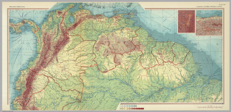
Author
Polish Army Topography Service
Full Title
Ecuador, Colombia, Venezuela, Guiana. (inset) Bogota. (inset) Caracas. Pergamon World Atlas. Pergamon Press, Ltd. & P.W.N. Poland 1967. Sluzba Topograficzna W.P.
List No
0737.219
Note
Detailed physical and political map.
Author
Society for the Diffusion of Useful Knowledge (Great Britain)
Full Title
South America sheet I. Ecuador, Granada, Venezuela, and parts of Brazil and Guayana. J. & C. Walker sculpt. Published by and under the superintendence of the Society for the Diffusion of Useful Knowledge, 59 Lincolns Inn Fields, Jany. 15th. 1842. (1844)
List No
0890.147
Note
Engraved map. Relief shown by hachures and spot heights. Boundaries hand col. Sources: Humboldt, Schomburgk, Codazzi &c.
Author
Stanford, Edward
Full Title
(Covers to) Colombia, Ecuador and Peru, also Panama. London: Edward Stanford, Ltd., 12, 13, & 14, Long Acre, W.C. London atlas series. Stanford's Geographical Establishment, London. (1922?)
List No
0947A
Note
Dark green cloth covered boards 18x12.5 with a yellow label reading: London Atlas Map of Colombia, Ecuador & Peru. London: Edward Stanford, Ltd. Cartographers to His Majesty the King, 12, 13, & 14, Long Acre, W.C.2.
Author
Stanford, Edward
Full Title
(Inside Covers to) Colombia, Ecuador and Peru, also Panama. London: Edward Stanford, Ltd., 12, 13, & 14, Long Acre, W.C. London atlas series. Stanford's Geographical Establishment, London. (1922?)
List No
0947B
Note
Inside front cover. List of "Stanford's atlases."
Author
Stanford, Edward
Full Title
Colombia, Ecuador and Peru, also Panama. (with Panama Canal Zone). (with) Galapagos Islands, Colon. London: Edward Stanford, Ltd., 12, 13, & 14, Long Acre, W.C. London atlas series. Stanford's Geographical Establishment, London. (1922?)
List No
0947.001
Note
Printed in full color by country. Map is dissected into 20 sections and mounted on linen. The covers are dark green cloth covered boards 18x12.5 with a yellow label reading: London Atlas Map of Colombia, Ecuador & Peru. London: Edward Stanford, Ltd. Cartographers to His Majesty the King, 12, 13, & 14, Long Acre, W.C.2. "1625." Relief shown by hachures and spot heights. Shows provinces, settlements, submarine cables, etc.
Author
Stanford, Edward
Full Title
Colombia, Ecuador and Peru. (inset) Galapagos Islands.
List No
0949.110
Note
Countries in full color. Relief shown by hachures and spot heights. Shows settlements, railroads, submarine telegraph cables, etc.
Author
Tanner, Henry S.
Full Title
Venezuela, New Grenada & Equador. (inset) Plan of a Proposed Communication between the Atlantic & Pacific Oceans.
List No
0976.038
Note
Date estimated. Prime meridian Washington.
Author
Tanner, Henry S.
Full Title
Venezuela, New Grenada & Equador. (with) Plan of a Proposed Communication Between the Atlantic & Pacific Oceans. J. Knight Sc. Published by H.S. Tanner Philadelphia. (above neat line) Tanner's Universal Atlas.
List No
0977.033
Note
In full color by region.
Author
Tanner, Henry S.
Full Title
Venezuela, New Grenada & Equador. (inset) Plan of a Proposed Communication between the Atlantic & Pacific Oceans.
List No
0980.041
Note
Date estimated. Prime meridian Washington.
Author
[Humboldt, Alexander von, 1769-1859, Bonpland, Aime]
Full Title
X. Volcan de Cotopaxi, 41
List No
10555.013
Author
[Humboldt, Alexander von, 1769-1859, Bonpland, Aime]
Full Title
XVII. Monument Peruvien. du Canar, 107.
List No
10555.020
Author
[Humboldt, Alexander von, 1769-1859, Bonpland, Aime]
Full Title
XIX. Ynga-Chungana, pres du Canar, 112.
List No
10555.022
Author
[Humboldt, Alexander von, 1769-1859, Bonpland, Aime]
Full Title
XX. lnterieur de la maison de I'Inca, au Canar, 114.
List No
10555.023
Author
[Humboldt, Alexander von, 1769-1859, Bonpland, Aime]
Full Title
XXIV. Maison de l'Inca, a Callo, dans le royaume de Quito, 195.
List No
10555.027
Author
[Humboldt, Alexander von, 1769-1859, Bonpland, Aime]
Full Title
XXXV. Montagne d'Ilinissa, 233.
List No
10555.038
Author
[Humboldt, Alexander von, 1769-1859, Bonpland, Aime]
Full Title
LI. Vue du Corazon, 273.
List No
10555.054
Author
[Humboldt, Alexander von, 1769-1859, Bonpland, Aime]
Full Title
LXI. Volcan de Pichincha, 291.
List No
10555.064
Author
[Humboldt, Alexander von, 1769-1859, Bonpland, Aime]
Full Title
LXIII. Radeau de la riviere de Guayaquil , 295.
List No
10555.066
Author
[Pan American World Airways, Coplan, Maxwell]
Full Title
Ecuador. Pan American World Airways. Printed in U.S.A.
List No
11385.000
Note
Color pictorial map of Brazil, with title cartouche. Shows agricultural products, industry and mining. Includes photographs and view of PAA air plane. Date estimated. On verso: "Credit: Kodachromes, Maxwell Coplan".
Author
Pan American World Airways
Full Title
Ecuador. Pan American World Airways. The system of the Flying Clippers. Educational Unit No. 3. CIAA Symbols copyrighted by Pictograph Corp. and Quarrie Corp.
List No
11581.000
Note
Color pictorial map with title cartouche decorated with the location map. Shows a Flying Clipper in upper right, capital city, agriculture, mining, and industry. Includes views of: Panama hats made in Ecuador; Cacao beans, source of Chocolate; Rafts of Balsa logs, float to market. Date estimated.
Author
[Pan American World Airways, Inc., Harrison, Richard Edes, Carlton Smith Associates, Pictograph Corporation]
Full Title
Ecuador. Pan American World Airways : the system of the Flying Clippers. Copyright 1945 Pan American World Airways, Inc. Basic map by Richard Edes Harrison. Map symbols copyrighted by Pictograph Corp. and Quarrie Corp.
List No
11590.015
Note
Promotional pictorial Pan American World Airways calendar in 28 pages, with 14 maps. Covers February 1945 to January 1946. "Acknowledgment: for much of the source materials used in the preparation of this calendar is given to: U.S. Dept. of Commerce (Bureau of Foreign and Domestic Commerce), Pan American Union, Pictograph Corporation and Quarrie Corporation". Front cover: Map of the world, shows the routes of the flying clipper in the world, view of Flying Clipper and text on both sides. Text on cover: "This 1945 calendar has many unusual features. It is more than a month-to-month time table, it is an authoritative, up-to-date encyclopedia ..." Back cover: "No Fantasy here", map of Latin America and United States, showing Pan American service routes. Each month showing a different destination in Latin America, includes pictorial map, illustrations and views, with information on various cities, populations, landmarks and points of interest on verso. Maps showing capitals, agriculture, industry, and landmarks. Includes views, notes and location map. Relief shown by shadings.
Author
Meyer, Joseph, 1796-1856
Full Title
(Columbia) Neu-Granada, Ecuador und Venezuela. 1849. (in upper margin) Meyer's Zeitung Atlas. No.17. (to accompany) Neuester Zeitungs-Atlas fur Alte und Neue Erdkunde. Herausgegeben von J. Meyer. (inset Profiles) Andes Kette. (with) Fall des Amazonen Stroms.
List No
11652.101
Note
Engraved outline hand color map. Shows boundaries, cities and towns. Includes list of provinces under the map. Relief shown by hachures. Prime meridian is Ferro.
Author
Estevanez, Nicolas, 1838-1914
Full Title
Colombia y Ecuador. Grabado por Guillot. Garnier Hermanos, Editores, Paris. Imp. Dufrenoy. (To accompany) Atlas geografico de America ... Por N. Estevanez. Paris : Libreria de Garnier Hermanos. 1885. (insets) Peninsula de Guajira. (with) Islas Galapagos.
List No
11936.010
Note
Color map. Engraved by E. Guillot. Shows administrative boundaries, capitals, cities, towns, rivers, roads, and railways. Relief shown by hachures and shadings. Includes Index and legend. Prime meridian is Paris.
Author
Marmocchi, Francesco C.
Full Title
25. Peru e Bolivia.
List No
12235.026
Author
[Stieler, Adolf, Habenicht, H., Petermann, A.]
Full Title
90. Sued-Amerika in 6 Blaettern, Bl. 1.
List No
12240.107
Author
[Ogilby, John, 1600-1676, Montanus, Arnoldus, 1625?-1683]
Full Title
Peru.
List No
12241.085
Author
[Stieler, Adolf, Haack, H.]
Full Title
104. Venezuela - Kolumbien - Ekuador.
List No
12248.218
Author
Petri, Girolamo
Full Title
Tav. CXVI. Colombia, province ecclesiastiche di Nuova Granata, Venezuela ed Equatore.
List No
14007.287
Note
Hand-colored, engraved map showing the ecclesiastical provinces of Colombia, New Granada, Venezuela and Ecuador. Text in delicate script circling land. Accompanied by descriptive text on facing page. In Volume III.
Author
[Weekly Dispatch, Lowry, Joseph Wilson, 1803-1879]
Full Title
Brazil, Bolivia, Peru & Ecuador : [West sheet] [East sheet]./ by J. W. Lowry, F. R. G. S. ; drawn & engraved by J. W. Lowry, Robert Street Hampstead Road ; E. Weller, Lithogr.
List No
14360.251
Note
Map of Brazil, Bolivia, Peru and Ecuador (west and east sheets). Shows political boundaries, cities, roads, topography, bodies of water, drainage, coastlines and islands. Relief shown with hachures. Includes latitudinal and longitudinal lines, as well as four bar scales given in geographical and English miles, and Portuguese and Spanish leagues. Hand-colored lithograph. Map is 45 x 62 cm, on two sheets, together 48 x 69 cm. Sheets presented in sequence. Appears in Vol. II : Foreign.
Author
[Weekly Dispatch, Lowry, Joseph Wilson, 1803-1879]
Full Title
(Composite Map to) Brazil, Bolivia, Peru & Ecuador : [West sheet] -- [East sheet] / by J. W. Lowry, F. R. G. S. ; drawn & engraved by J. W. Lowry, Robert Street Hampstead Road ; E. Weller, Lithogr.
List No
14360.252
Note
Composite map of Brazil, Bolivia, Peru and Ecuador (west and east sheets). Shows political boundaries, cities, roads, topography, bodies of water, drainage, coastlines and islands. Relief shown with hachures. Includes latitudinal and longitudinal lines, as well as four bar scales given in geographical and English miles, and Portuguese and Spanish leagues. Hand-colored lithograph. Map is 45 x 62 cm, on two sheets, together 48 x 69 cm. Sheets presented in sequence. Appears in Vol. II : Foreign.
Author
Cram, George Franklin, 1841-1928
Full Title
Venezuela, Colombia, Ecuador, British, Dutch and French Guiana.
List No
14372.306
Note
Map of the Venezuela, Colombia, Ecuador, British, Dutch and French Guiana. Shows political boundaries, cities, railroads, topography, bodies of water, drainage, coastlines and islands. Relief shown with hachures. Includes latitudinal and longitudinal lines. Provides figures for square milage and population. Inset map: Galapagos Islands. Map indexed to indicate place names. Colored lithograph. Map is 40 x 55 cm, on double sheet 45 x 67 cm.
Author
Arrowsmith, John, 1790-1873
Full Title
Colombia, dedicated to Colonel Belford Hinton Wilson, late Aid de Camp to the liberator, Simon Bolivar, by his obliged servant J. Arrowsmith. London Pubd. 15 Feby. 1858, by J.Arrowsmith, 10 Soho Square
List No
14506.126
Note
Map representing current-day Colombia, Venezuela, Guyana, Ecuador, and part of Brazil. Shows political boundaries, topography, cities, roads, bodies of water, drainage, coastlines, and islands. Relief shown with hachures. Includes a legend, latitudinal and longitudinal lines, as well as bar scales given in English miles and Spanish leagues. Map is 47 x 61 cm, on double sheet 56 x 67 cm.
Author
Colton, G.W.
Full Title
Colton's Venezuela, United States of Colombia and Ecuador. Published By G. W & C. B. Colton & Co., No. 182 William St. New York.
List No
1550.071
Note
Prime meridians are Washington D.C. and Greenwich. Note on Peruvian claims to part of the Amazon.
Author
Bartholomew, John
Full Title
(Index to) Venezuela, Colombia, Ecuador. Lambert Zenithal Equal-Area Projection, Centre 20 (degrees) S., 64 (degrees) W. 1:5,000,000.
List No
1552.293
Note
Uncolored index map. Key to adjoining areas.
Author
Bartholomew, John
Full Title
Venezuela, Colombia, Ecuador. The Geographical Institute Edinburgh. Edited by John Bartholomew, M.C. LL. D. Copyright - John Bartholomew & Son, LTD. (inset maps) Islas Galapagos (Archipielago de Colon), and I. de Malpelo.
List No
1552.294
Note
Full color map. Relief shown by shadings and spot heights. Depth shown by shadings and soundings. Prime meridian is Greenwich. No. 1440 and Nov. 56 marked on the lower corners of plate. The Times Atlas on the upper left corner.
Author
[Black, Adam, Black, Charles]
Full Title
Venezuela, Colombia, Equador, Peru &c.
List No
1585.080
Author
Blackie, W.G.
Full Title
Venezuela, United States of Colombia (or New Granada), and Ecuador.
List No
1589.080
Author
[Cram, George Franklin, Murray-Aaron, Eugene, 1852-1941.]
Full Title
Columbia, Ecuador, Venezuela, British Dutch and French Guiana. Published by George F. Cram, Chicago, Ill. (to accompany) Cram's atlas of the world, ancient and modern : new census edition -- indexed. (inset continuation of east part of map) (with) Galapagos Islands (to Ecuador).
List No
1910.120
Note
Color map on 2 pages. . Shows British, French and Dutch occupation in South America, cities and towns, roads, etc. Relief shown by hachures. Prime meridian is Greenwich.
|


![Brazil, Bolivia, Peru & Ecuador : [West sheet]. [East sheet].](https://www.davidrumsey.com/rumsey/Size2/RUMSEY~8~1/199/14360251.jpg)
![Composite Map: Brazil, Bolivia, Peru & Ecuador : [West sheet] ...](https://www.davidrumsey.com/rumsey/Size2/RUMSEY~8~1/205/14360252.jpg)


