|
REFINE
Browse All : Images of Detroit (Mich.)
1-39 of 39
Author
[Ford Motor Company, United States. Army. Air Corps]
Full Title
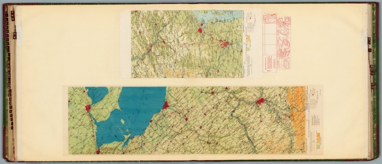
Air navigation map no. 45 (experimental) : Uniontown, Pittsburgh, Pa. to Cleveland, O. and Mt. Clemens, Mich. Compiled and reproduced by the Engineer Reproduction Plant, Corps of Engineers. Under the direction of the Airways Section, Office Chief of Air Corps. 1925. Engineer Reproduction Plant, U.S. Army, Washington Barracks, D.C. 6158. R-1928. -- Air navigation map [46] (experimental) : Washington, D.C. to Middletown, Pa. Compiled and reproduced by the Engineer Reproduction Plant, Corps of Engineers. Under the direction of the Airways Section, Office Chief of Air Service. 1925. Engineer Reproduction Plant, U.S. Army, Washington Barracks, D.C. 4915-46.
List No
14501.026
Note
Two aeronautical charts representing the areas from Uniontown, Pittsburgh, Pennsylvania, to Cleveland, Ohio and Mount Clemens, Michigan, and from Washington, D.C., to Middletown, Pennsylvania. Features military, municipal, commercial, emergency, and seaplane landing fields. Also shows political boundaries, roads, railways, cities, towns, topography, bodies of water, drainage, and coastlines. Relief shown with contour lines and color coding. Maps include latitudinal and longitudinal lines, legend, scale statements, and bar scales given in miles, as well as compass roses oriented toward left of sheet (with slight variation between the two maps). aeronautical chart 46 includes six inset maps showing route and landing facilities. Color lithographs. Together, maps are 56 x 97 cm, on double sheet, 60 x 135 cm. Map number 46 provided with a handwritten annotation.
Author
[Ford Motor Company, United States. War Department. Office of the Chief of Air Service, United States. Army. Air Corps]
Full Title
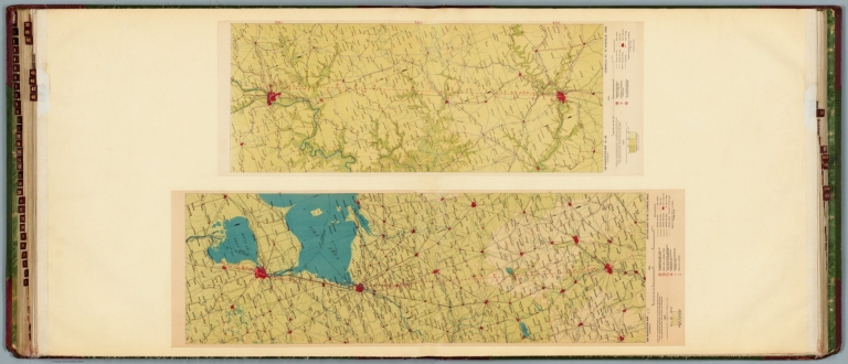
Air navigation map [47] (experimental) : Dayton, Ohio to Mt. Clemens, Mich. Compiled and reproduced by the Engineer Reproduction Plant, Corps of Engineers. Under the direction of the Airways Section, Office Chief of Air Service. 1925. Engineer Reproduction Plant, U.S. Army, Washington Barracks, D.C. 4915-47. 1926. -- Air navigation map 48 (experimental) : Louisville, Ky. to Nashville, Tenn. Compiled and reproduced by the Engineer Reproduction Plant, Corps of Engineers. Under the direction of the Airways Section, Office Chief of Air Corps. 1927. Engineer Reproduction Plant, U.S. Army, Washington Barracks, D.C. 6275-48.
List No
14501.027
Note
Two aeronautical charts representing the areas from Dayton, Ohio, to Mount Clemens, Michigan, and from Louisville, Kentucky, to Nashville, Tennessee. Features military, municipal, commercial, emergency, and seaplane landing fields. Also shows political boundaries, roads, railways, cities, towns, topography, bodies of water, drainage, and coastlines. Relief shown with contour lines and color coding. Maps include latitudinal and longitudinal lines, legend, scale statements, and bar scales given in miles, as well as compass roses oriented toward left of sheet (with slight variation between the two maps). Color lithographs. Together, maps are 56 x 86 cm, on double sheet, 60 x 135 cm. Map number 47 provided with a handwritten annotation.
Author
[Hickmann, Anton Leo, 1834-1906, Fischer, Alois, b. 1894]
Full Title
Vergleichende größe der bedeutendsten städte der Erde: III. G. Freytag & Berndt A.G., Wien. (to accompany) Prof. Hickmann's Geographisch-statistischer universal-atlas, 1927.
List No
13687.051
Note
11 maps and notes on 1 page. Part III: Comparative size of the most important cities in the world.
Author
Trans World Airlines
Full Title
Map no. 2 : Chicago - Pittsburgh, principal cities in Ohio, Detroit, South Bend, Louisville, Indianapolis.
List No
14394.004
Note
Map of the air routes connecting Chicago, Pittsburgh, principal cities in Ohio, Detroit, South Bend, Louisville and Indianapolis, as well as the greater vicinity. Also shows cities, airports, highways, railways, topography, bodies of water, coastlines, islands and time zones. Relief shown with shading and peak heights. Includes a legend and descriptive text, as well as notes throughout. With views featuring popular tourist sites, such as the Sears Tower of Chicago. Also with inset index map indicating the geographic location of the main map within the United States. Colored lithograph. Map is 26 x 37 cm, on double sheet 26 x 52 cm.
Author
[Whitney-Graham Company, Inc., Detroit Edison Company]
Full Title
The Detroit Edison system. 4-28. (to accompany) The blue book of map making : America's map makers. R.W.C. The Whitney-Graham Co. Inc.
List No
11489.003
Note
Colored pictorial map. Shows 120,000 volt tower lines, transmission lines, heating, gas and water power plants and substations. Includes compass rose oriented with the north to the upper right margin. Relief shown by shadings.
Author
Appleton, D. & Co.
Full Title
Map of Detroit, Michigan. Copyright 1891 by Matthews-Northrup Co. ... Buffalo, New York. (to accompany) The Library Atlas Of Modern Geography ... New York, D. Appleton And Company 1892. (on upper margin) Detroit, 73.
List No
0026.192
Note
Color plan of Detroit. Shows railways, street car lines, blocks, parks, canals, etc. Includes numerical references to Depots, hotels, churches, major buildings, and points of interest.
Author
Mitchell, Samuel Augustus
Full Title
Plan of Detroit. Entered ... 1879 by S. Augustus Mitchell ... Washington. (1880)
List No
0586.038
Note
Hand colored. Shows wards, railroads, major buildings, etc.
Author
Mitchell, Samuel Augustus Jr.
Full Title
Plan of the city of Detroit.
List No
0592.041
Note
Hand colored. Shows wards, railroads, major buildings, etc.
Full Title
Plan of the city of Detroit. Copyright 1887 by Wm. M. Bradley & Bro. (1890)
List No
0594.039
Note
Hand colored. Shows wards, railroads, major buildings, etc.
Author
Polish Army Topography Service
Full Title
United States of America - (Chicago, Detroit, and Philadelphia). Pergamon World Atlas. Pergamon Press, Ltd. & P.W.N. Poland 1967. Sluzba Topograficzna W.P.
List No
0737.204
Note
Three maps: Chicago, Detroit, and Philadelphia.
Author
[Passonneau, Joseph R., Wurman, Richard Saul]
Full Title
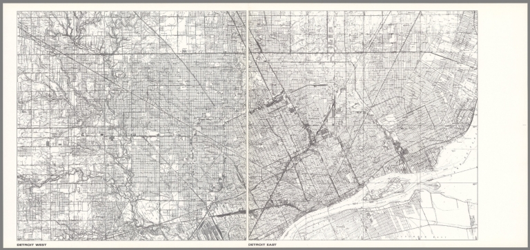
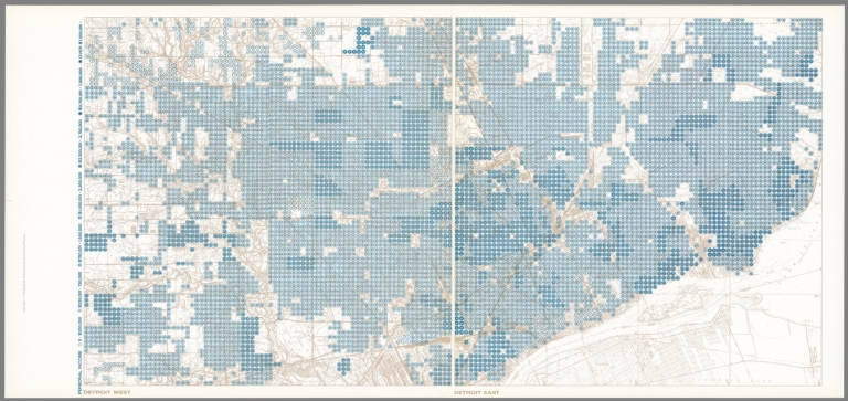
Detroit West; Detroit East.
List No
10195.034
Author
[Passonneau, Joseph R., Wurman, Richard Saul]
Full Title
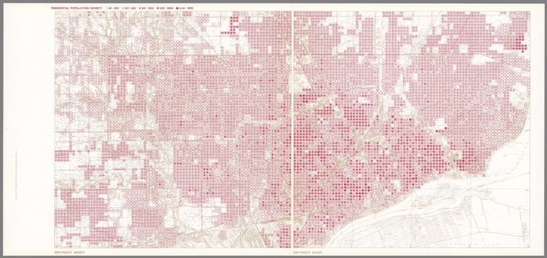
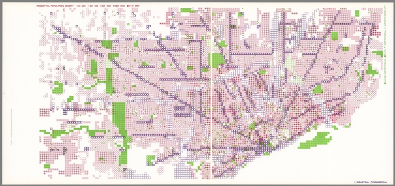
Detroit West; Detroit East. Residential Population Density.
List No
10195.035
Author
[Passonneau, Joseph R., Wurman, Richard Saul]
Full Title
Detroit West; Detroit East. Residential Population Density; Industrial, Commercial; Large Institutional, Park, Institutional, Airport, Cemetery.
List No
10195.036
Author
[Passonneau, Joseph R., Wurman, Richard Saul]
Full Title
Detroit West; Detroit East. Personal Income.
List No
10195.037
Author
[Passonneau, Joseph R., Wurman, Richard Saul]
Full Title
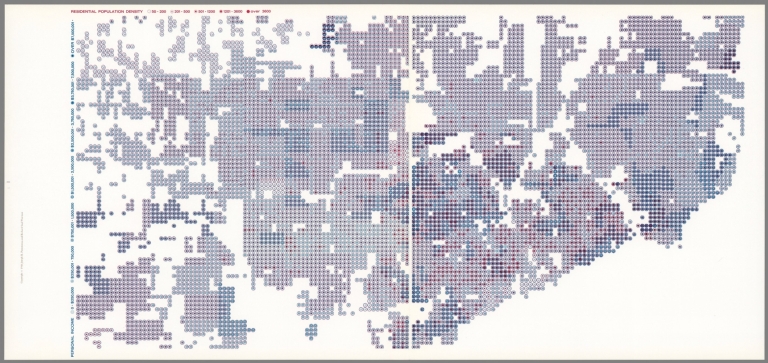
Detroit West; Detroit East. Personal Income; Residential Population Density.
List No
10195.038
Author
[Robinson, Eugene, Walling, H. F.]
Full Title
Map of the City of Detroit, 1873. Compiled by Eugene Robinson, City Surveyor. Ent'd. ... 1871 by Eugene Robinson ... Washington. The Calvert Lith. Co., Detroit. (Drawn, compiled, and edited by H.F. Walling, C.E. ... Published by R.M. & S.T. Tackabury, Detroit, Mich. Entered ... 1873, by H.F. Walling ... Washington. The Claremont Manufacturing Company, Claremont, N.H., Book Manufacturers)
List No
1147.079
Note
Hand col. lithographed map. Shows wards, railroads and stations, etc.
Author
[Nirenstein, Nathan, Funk & Wagnalls Company.]
Full Title
Nathan Nirenstein's One Hundred Per Cent Business Real Estate Locations, Detroit (Michigan).
List No
12508.029
Note
Date estimated.
Author
Rand McNalley & Company
Full Title
Cleveland, Ohio, and vicinity -- Detroit, Mich. -- Dayton, Ohio -- Dallas, Tex. -- Denver, Colo.
List No
14003.056
Note
5 road maps of cities. Maps include compass roses and legends. Copyright by Rand McNally & Company, Chicago, Ill. Lithographed in the U.S.A.
Author
Geological Survey (U.S.)
Full Title
Urban areas : Milwaukee, Wis. -- Cleveland, Ohio -- Chicago, Ill. -- Detroit, Mich. -- Pittsburgh, Pa. -- Buffalo, N.Y. -- Cincinnati, Ohio -- Boston, Mass. -- Philadelphia, Pa. -- Atlanta, Ga. -- New Orleans, La. -- Miami, Fla.
List No
14359.035
Note
Twelve maps representing urban areas in the United States, as of 1970. Maps show political boundaries, cities, railways, roads, ferry lines, national forests, mountains, bodies of water, swamps, drainage, coastlines and islands. Relief shown with labeling of mountain names and peak heights. Features population density for each city. Maps include latitudinal and longitudinal lines and scale statements. Colored lithograph. Together, maps are 42 x 65 cm, on double sheet 49 x 71 cm. Index map and legend appear on page 5. Maps appear in General reference maps section.
Author
Geological Survey (U.S.)
Full Title
1:1,000,000-Scale topographic maps, status as of July 1969 : [United States] -- Topographic map : [Trinity, Lassen and Plumas National Forests] / compiled by U. S. Geological Survey, 1969 -- 1:1,000,000-Scale sectional maps : [United States] -- Sectional map : [Chicago and Detroit areas].
List No
14359.236
Note
Four maps representing the United States, as well as the Trinity, Lassen and Plumas National Forests, and the Chicago and Detroit areas, featuring the geographic locations of both 1:1,000,000 and 1:2,000,000 maps, as of 1969. Maps show political boundaries, cities, railways, roads, topography, bodies of water, drainage, coastlines and islands. Relief shown with contour lines, shading and peak heights. Maps include legends, as well as bar scales and scale statements (scales differ). Maps of the United States each have two inset maps: Principal islands of Hawaii -- Hawaii. Maps of the United States, Alaska and Hawaii (presented with Albers Equal Area Projection) provide indexes to other maps with further detail. Colored lithograph. Together, maps are 42 x 31 cm, on sheet 49 x 35 cm. Accompanied by descriptive text here, as well as on page 303. Maps appear in Special subject maps section, subsection Mapping and charting.
Author
Cram, George Franklin, 1841-1928
Full Title
Detroit.
List No
14372.281
Note
Map of Detroit, Michigan. Shows political boundaries, railroads, streets, bridges, parks, bodies of water, drainage and shoreline. Includes a legend, compass rose with north oriented toward upper left, as well as circles of distance from the city center, given in miles. Colored lithograph. Map is 24 x 30 cm, on sheet 33 x 45 cm.
Author
[Colton, G.W., Fisher, Richard Swainson]
Full Title
Michigan and Wisconsin. (inset) Vicinity of Milwaukee. (inset) Vicinity of Detroit.
List No
1690.114
Author
[Cram, George Franklin, Murray-Aaron, Eugene, 1852-1941.]
Full Title
Detroit. Published by George F. Cram, Chicago, Ill. (to accompany) Cram's atlas of the world, ancient and modern : new census edition -- indexed.
List No
1910.087
Note
In full color on 2 pages. Shows city blocks, railroads, roads, river, public buildings, parks, etc.
Author
Cram, George Franklin
Full Title
City of Detroit, Michigan.
List No
2809.098
Author
Rand McNally and Company
Full Title
Detroit and Vicinity. (with) Map of Detroit and Vicinity.
List No
2844.051
Author
Rand McNally and Company
Full Title
Rand, McNally & Co.'s indexed atlas of the world map of Detroit and vicinity. Copyright, 1893, by Rand, McNally & Co. (Chicago, 1897)
List No
3565.119
Note
Col. map. Shows major buildings, cemeteries, etc. Inset: Map of Detroit and vicinity. Scale (ca. 1:170,000). Title in margin: Rand, McNally & Company's indexed atlas of the world.
Author
Mitchell, Samuel Augustus Jr.
Full Title
Plan of Detroit. Entered ... 1873, by S. Augustus Mitchell ... Washington.
List No
3804.040
Note
Hand colored map. Shows wards, major buildings, railroads, roads, rivers, etc.
Author
Mitchell, Samuel Augustus Jr.
Full Title
Plan of Detroit. Entered ... 1877 by S. Augustus Mitchell, . ... Washington.
List No
4564.041
Note
Full color map. Shows wards, railroads, major buildings, etc.
Author
Cram, George Franklin
Full Title
Detroit.
List No
4727.078
Note
With printed color.
Author
Rand McNally and Company
Full Title
Commercial Atlas of America. Rand McNally 14 x 21 Inch Map of Detroit and Vicinity.
List No
5028.079
Note
Shows railroads, main roads, and key locations.
Author
Mitchell, Samuel Augustus Jr.
Full Title
Plan of Detroit.
List No
5041.036
Full Title
Plan of the city of Detroit. Copyright 1886 by Wm. M. Bradley & Bro.
List No
5784.039
Note
Hand colored. Shows wards, railroads, major buildings, etc.
Author
Shell Oil Company
Full Title
Shell Map of Metropolitan Detroit (cover title). Metropolitan Detroit and Vicinity. 1956-1 12-DD.
List No
5840.123
Author
Shell Oil Company
Full Title
Downtown Detroit. Sightseeing Guide to Detroit. (Verso to) Metropolitan Detroit and Vicinity.
List No
5840.124
Note
Includes a description of the city and sights.
Author
Bellin, Jacques Nicolas, 1703-1772
Full Title
Le Detroit de Belle-Isle.
List No
6903.022
Note
Decorative title cartouche. Relief shown by hachures.
Author
[Benedict, Bozidar Damjanovic, Archar Inc.]
Full Title
Detroit. City design Print. Produced and Published by Archar Inc. P.O. Box 2156 Station B, Scarburough, Ontario, Canada, (copyright) 1977. Printed in U.S.A. Illustrated by Bozidar Damjanovic - Benedict.
List No
8393.000
Note
Pictorial map, filled with noted illustrations of buildings and landmarks, bridges, scenic highlights and attractions. Includes modes of transportation such as cars, airplanes, ships and boats. Shows mall figures of people engaged in activities, mainly automotive manufacturing industry.
Author
Peacock, Jerry
Full Title
A pictorial Map of Wayne University 1939 by Jerry Peacock. Printed in U.S.A. Drawn with artistic License by Jerry Peacock.
List No
8444.000
Note
Pictorial view of Wayne University campus. Detail map showing various buildings, graduating students crossing Cass Avenue in caps and gowns, Detroit River located south of campus. Around the border of the map are written the words of the first verse of "Green and Gold," the fight song of Wayne University.
Author
Curtis Publishing Company
Full Title
Detroit.
List No
9687.044
Author
Rand, McNally & Co.
Full Title
Detroit and Vicinity.
List No
9733.115
1-39 of 39
|


![1:1,000,000-Scale topographic maps, status as of July 1969 : [United States] ...](https://www.davidrumsey.com/rumsey/Size1/RUMSEY~8~1/199/14359236.jpg)


