|
Author
Stimson, Julia M.
Full Title
The Making of Colorado
List No
15310.000
Author
Be, Kenny
Full Title
Colorado
List No
15361.000
Author
Cram, George Franklin, 1841-1928
Full Title
Colorado. 1899, by Geo. F. Cram.
List No
14372.114
Note
Map of Colorado. Shows political boundaries, counties, towns, railroads, topography, bodies of water, drainage, coastlines and islands. Relief shown with hachures. Includes key with explanation, latitudinal and longitudinal lines, as well as a bar scale given in miles. With alphanumeric grid corresponding to "Index of Colorado" on pages 208-211 and 214-215. Colored lithograph. Map is 40 x 55 cm, on double sheet 45 x 67 cm. "Index of maps" and "Index of cities" in margins, providing navigation for atlas as a whole.
Author
Mid-West Map Company
Full Title
Highway map & guide of Colorado. Mid-West Map Co. Aurora, Mo.
List No
14410.002
Note
Pocket road map for the state of Colorado. Shows state boundaries, cities, highways, roads, airports, parks, topography, bodies of water and drainage. Relief shown with hachures. Includes explanatory text, a legend, bar scale given in miles, and compass rose with north oriented toward top of sheet. Indexed, with key on verso. Advertisement in margins. Printed in blue. Map is 40 x 53 cm, on sheet 44 x 56 cm.
Author
[Fisher, Joseph R., Planters Peanuts (Firm)]
Full Title
Colorado : The centennial state -- Nebraska : The cornhusker state -- West Virginia : The mountain state -- Ohio : The buckeye state.
List No
14374.008
Note
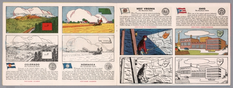
Four views, representing Colorado, Nebraska, West Virginia and Ohio. Views show examples of the landscape and natural resources. Each view includes an inset map of the state, which marks the location of the capital city with a star. Accompanied by descriptive text, the state flags, seals and flowers: columbine, goldenrod, big rhododendron and scarlet carnation, respectively. The view of each state appears both in color (on top) and in black and white (bottom), the latter inviting coloration. Together, views are 18 x 52 cm, on two sheets 20 x 54 cm.
Author
Fine, W.J.
Full Title
Map of the Gunnison Gold Belt Colorado.
List No
10838.001
Author
Waldmire, Robert, 1945-2009
Full Title
Boulder and the University of Colorado. Another Slice o' life poster of another American town, by Android, # 345-36-5919.
List No
13635.000
Author
Cram, George Franklin, 1841-1928
Full Title
Cram's railroad and township map of Colorado. Published by Geo. F. Cram. 262-264 Wabash Ave. Chicago, Ills. 1882.
List No
14250.028
Note
Map of Colorado, showing railroads, county boundaries, cities and towns, and drainage. Political boundary lines in color. With index numbers along the perimeter, and decorative border. Also, with hand-drawn annotations tracing routes of travel, both along railroads and across landscapes where no official transit appears. 40 x 52 cm, on sheet 45 x 58.
Author
Colorado Ry. Co.
Full Title
Topographical Map of Ralston Creek - Station 1283-2093 "H.T. Line T.R. Countryman Eng. 1886 Traced from Sheets Sept. 1914. P-3015-26_3
List No
10303.000
Note
Blueprint.
Author
[Hayden, Ferdinand Vandeveer, 1829-1887, Russell, Andrew Joseph, 1830-1902]
Full Title
Skull Rock - (granite) Sherman Station, Laramie Mountains. (to accompany) Sun pictures of Rocky Mountain scenery ... by F. V. Hayden, ... New York : Julius Bien, 1870.
List No
13389.007
Note
Black and white view of Skull Rock. Shows rock formation.
Author
Bloodgood, Don
Full Title
A Pic-Tour Map of Colorado. Don Bloodgood. (cover title) Your Souvenir Pic-Tour Map of Colorado. The Summer Playground and the Winter Wonderland. Where to go and how to really see Colorado. A Micro-Krom product by H. S. Crocker Co., Inc. Los Angeles.
List No
11895.002
Note
Pictorial map of Colorado, depicting iconic national parks and other scenic areas, on sheet 46x56, folded in mailing envelope 23x14, with title: "Here is Colorado". Map showing cities, roads, railroads, rivers, straits, sounds, towns, mountain ranges, glaciers, wildlife, landmarks, and many scenes and the activities common in the area. Includes text. Relief shown pictorially. On verso: color views with explanatory text. Date estimated.
Author
[Berghaus, Heinrich, Berghaus, Hermann, Schmidt, C., Risch, M.]
Full Title
Tieflander. Entw. v. Herm. Berghaus 1883, Ausg. 1887. Gez. v. C. Schmidt u. M. Risch. Gotha: Justus Perthes. (On upper margin) I. Abt. Geologie No. II. Berghaus' physikal atlas No. 2. (to Accompany) Berghaus' Physikalischer Atlas. (Begrundet 1836 durch Heinrich Berghaus) ... Gotha: Justus Perthes. 1892.
List No
4391.013
Note
14 color lithograph maps with insets on 1 sheet. Includes: Die Heutigen Niederlande, with insets: Niederlande in 1. Jahrhundert -- Niederlande in X. Jahrhundert, at scale of 1: 6,000,000. Fen District -- El-Ghor oder das Jordan Thal -- Kaspisches Tiefland und Manytsch Niederrung -- Natron-Seen -- El Fajum -- Nordrand der Libyschen Wuste -- Das Todte Thal -- Colorado-Wuste -- Nordrand der Algerischen Sahara -- Goban n. Paulistischke -- Sud-Australische Seen -- Tiefland Asale -- Assal-See. Relief shown by contours and spot heights. Depth shown by gradient tints and soundings. Prime meridian is Greenwich.
Author
[United States Bureau of Topographical Engineers, Dougal, W.H.]
Full Title
Old Territory and Military Department of New Mexico : compiled in the Bureau of Topogl. Engrs. of the War Dept. chiefly for military purposes. Under the authority of the Secretary of War 1850. Partially revised and corrected to 1867. Engraved by W. H. Dougal.
List No
11231.000
Note
Uncolored map, published prior to and revised after the Civil War. List of Authorities identifies 19 maps created by explorers of the region published between 1843 and 1858. Shows boundaries, principal travel routes, trails, mail routes, cities and villages, rivers and creeks. Includes list of Principal latitudes & longitudes astronomically determined. Includes notes.
Author
Nell, Louis
Full Title
(Covers to) Nell's Topographical & Township Map of the State of Colorado. Compiled from U.S. Government Surveys & other authentic Sources. Washington D.C. 1884. Chain & Hardy, Agents. 414 Larimer Str. Denver. Entered ... 1881, by Louis Nell ... Washington D.C. Am. Photo-Litho. Co. N.Y.
List No
0662A
Author
Nell, Louis
Full Title
Nell's Topographical & Township Map of the State of Colorado. Compiled from U.S. Government Surveys & other authentic Sources. Washington D.C. 1884. Chain & Hardy, Agents. 414 Larimer Str. Denver. Entered ... 1881, by Louis Nell ... Washington D.C. Am. Photo-Litho. Co. N.Y.
List No
0662.001
Note
Full color by county. Nell did many of the Wheeler survey maps. The Ellis copy of this map was issued in Washington by Stone & Co. Folded into textured dark green cloth covers 17x10.5 with "Nell's Topographical And Township Map Of The State Of Colorado." stamped in gilt.
Author
U.S. General Land Office
Full Title
Department Of The Interior General Land Office J.A. Williamson, Commissioner. State of Colorado. 1879. Compiled from the official Records of the General Land Office and other sources by C. Roeser, Principal Draughtsman G.L.O. Photo lith & print by Julius Bien 16 & 18 Park Place N.Y.
List No
5447.000
Note
Printed color with Rocky Mountains shown by hachures. Military and Indian reservations highlighted by color.
Author
Appleton, D. & Co.
Full Title
Map of Colorado. Copyright 1891 by Matthews-Northrup Co. ... Buffalo, New York. (to accompany) The Library Atlas Of Modern Geography ... New York, D. Appleton And Company 1892. (on upper margin) Colorado. 57.
List No
0026.148
Note
Color map. Shows county boundaries and county seat, capital, railways, roads, etc. "Size of type indicates importance of the places". Includes notes. Relief shown by hachures. Prime meridians are Greenwich and Washington.
Author
Arbuckle Bros.
Full Title
Colorado, Utah, Montana, Minnesota. Copyright 1889 Arbuckle Bros. N.Y.
List No
0027.007
Note
Sheet with maps of four states in full color. The Colorado plains are known as a "paradise for invalids" due to the mildness and purity of the atmosphere. Each card measures 7.5 x 12.5 cm.
Author
Asher & Adams
Full Title
Asher & Adams' Colorado. Entered according to Act of Congress in the year 1874 by Asher & Adams ... at Washington. (New York, 1874)
List No
0041.033
Note
Hand col. engraved map. Shows townships, distances along railroads, etc. Prime meridians: Greenwich and Washington.
Author
Colton, G.W.
Full Title
Colton's Map of California, Nevada, Utah, Colorado, Arizona & New Mexico. Published By J. H. Colton. No. 172 William St. New York.
List No
0151.062
Note
Shows routes, dates of exploration and the explorers. Prime meridians are Greenwich and Washington D.C. Relief shown by hachures
Author
Colton, G.W.
Full Title
Colton's Map of California, Nevada, Utah, Colorado, Arizona and New Mexico. Published By G. W & C. B. Colton & Co. No. 172 William St. New York.
List No
0152.064
Note
Prime meridians are Washington D.C. and Greenwich.
Author
Colton. G.W. & C.B.
Full Title
(Covers to) Colton's Sectional & Topographical Map of Colorado. Published by G.W. & C.B. Colton & Co. 172 William St. New York. 1871. Entered ... 1871 by G.W. & C.B. Colton & Co. ... Washington.
List No
0164.001
Note
This map may be related to the Monk/Gilpin Colorado of 1865 (see Ellis p. 76, and see our #3509) - Colton republished the Monk/Gilpin in 1866 and that was very likely the base for this map. This is one of the most attractive of the early Colorado maps - Ellis calls it "a very good map and on a large scale." The hachuring used to indicate mountains and drainage is unusual and visually distinctive. Full color by county, folded into dark brown cloth covers 15.5x9.5 with "Topographical Map Of Colorado G.W. & C.B. Colton & Co" in gilt. Prime meridians are Greenwich and Washington D.C. Relief shown by hachures.
Author
Colton. G.W. & C.B.
Full Title
Colton's Sectional & Topographical Map of Colorado. Published by G.W. & C.B. Colton & Co. 172 William St. New York. 1871. Entered ... 1871 by G.W. & C.B. Colton & Co. ... Washington.
List No
0164.002
Note
This map may be related to the Monk/Gilpin Colorado of 1865 (see Ellis p. 76, and see our #3509) - Colton republished the Monk/Gilpin in 1866 and that was very likely the base for this map. This is one of the most attractive of the early Colorado maps - Ellis calls it "a very good map and on a large scale." The hachuring used to indicate mountains and drainage is unusual and visually distinctive. Full color by county, folded into dark brown cloth covers 15.5x9.5 with "Topographical Map Of Colorado G.W. & C.B. Colton & Co" in gilt. Prime meridians are Greenwich and Washington D.C. Relief shown by hachures.
Author
Cram, George Franklin
Full Title
Colorado.
List No
0210.046
Note
Prime meridians Greenwich and Washington.
Author
Gray, O.W.
Full Title
Gray's Atlas Map of Colorado. 1873.
List No
0310.074
Author
[Gray, Frank A., Gray, O.W.]
Full Title
Colorado.
List No
0312.050
Author
Johnson, A.J.
Full Title
Johnson's Nebraska, Dakota, Colorado, Idaho, Kansas. By Johnson And Ward.
List No
0352.041
Note
Full color by county, with heavy outlines around the states. Idaho and Kansas printed uncolored. Interesting transitional map of the region, featuring a massive oversized Idaho. Shows rivers and springs. Relief shown by hachures. Prime meridians are Greenwich and Washington D.C.
Author
Johnson, A.J.
Full Title
Johnson's California, With Territories of Utah, Nevada, Colorado, New Mexico And Arizona,Published By Johnson and Ward. Entered ... 1864, by A.J. Johnson ... New York.
List No
0352.044
Note
Full color by counties, with heavy outlines around the states. detail mining districts, political divisions, emigrant trails, the Santa Fe Trail, the Pony Express Route, several proposed Union Pacific railroads, and Indian tribes and territories. This important map went through several different states during its publication period from 1860 to 1870. This critical period in westward expansion saw incredible development and change throughout the region. This, the 1864 Johnson and Ward version represents a complete re-engraving of the 1862-1863 map. Johnson added considerable detail in the mountainous regions of California, Nevada and Colorado. Arizona and New Mexico appear as independent territories but shows the old "New Mexico" county structure. The southern boundary of Nevada with Arizona is set at 37 degrees of Latitude such that Las Vegas, shown within Arizona. Relief shown by hachures. Prime meridians are Greenwich and Washington D.C.
Author
Johnson, A.J.
Full Title
Johnson's California also Utah, Nevada, Colorado, New Mexico, and Arizona. Entered ... 1864.
List No
0358.049
Author
Leahy, J.F.
Full Title
(Index Page to) Leahy's Hotel Guide and Railway Distance Maps. Colorado.
List No
0425.016
Note
Alphabetical index list of the Hotels of the town with the number of rooms of each, their rates per day and the population of the town. Includes population of the state.
Author
Leahy, J.F.
Full Title
Leahy's Hotel Guide and Railway Distance Map of the State of Colorado. Published by American Hotel Register Company. Leahy Build., 228-234 W. Ontario St., Chicago, Ill. Copyrighted by J.F. Leahy, Jan., 1934.
List No
0425.017
Note
Map printed without color. Includes name of the railroad entering the town, and distance between towns.
Author
Mitchell, Samuel Augustus Jr.
Full Title
Map of Kansas, Nebraska and Colorado. Showing also the southern portion of Dacotah. Drawn & Engraved by W.H. Gamble Philada. Entered ... 1861 by S. Augustus Mitchell, Jr. ... Pennsylvania.
List No
0572.037
Note
Full color map by county. Shows settlements, Indian tribes, railroads, etc. Covers also parts of Wyoming, Iowa, Indian Territory, New Mexico and Texas. Relief shown by hachures. Prime meridians are Greenwich and Washington, D.C.
Author
Mitchell, Samuel Augustus Jr.
Full Title
Map of Kansas, Nebraska and Colorado. Showing the Southern Portion of Dacotah. Drawn and Engraved by W.H. Gamble Philada. Entered ... 1867 by S. Augustus Mitchell, Jr. ... Pennsylvania.
List No
0579.040
Note
Color map by state and county. Relief shown by hachures. Prime meridians are Greenwich and Washington, D.C.
Author
Mitchell, Samuel Augustus
Full Title
Colorado. Entered ... 1879 by S. Augustus Mitchell ... Washington. (1880)
List No
0586.044
Note
Hand colored. Relief shown by hachures. Shows counties, townships, Confederate Ute Indian Reservation, settlements, railroads, rivers, etc. Prime meridians: Greenwich and Washington.
Author
Mitchell, Samuel Augustus Jr.
Full Title
Colorado. Copyright by S. Augustus Mitchell 1884.
List No
0592.046
Note
Hand colored. Relief shown by hachures. Shows settlements, railroads, rivers, etc. Prime meridians: Greenwich and Washington.
Full Title
Colorado. Copyright 1887 by Wm. M. Bradley & Bro. (1890)
List No
0594.044
Note
Hand colored. Relief shown by hachures. Shows settlements, railroads, rivers, etc. Prime meridians: Greenwich and Washington.
Author
[Morse, Charles W., Colby, Charles A.]
Full Title
California. (inset) Utah and Part of New Mexico.
List No
0623.041
Author
Nell, Louis
Full Title
(Covers to) Nell's Topographical Map Of The State Of Colorado. E.Besly & Co. Publishers, Denver. 1889. Copyright by Louis Nell, Washington D.C. 1887. Photo-Lith., Century Lith. Co. Phila. Pa.
List No
0664.001
Note
Full color by county. Folded into textured dark green cloth covers 17x10.5 with "Nell's Map of Colorado, E. Besly & Co., Denver." stamped in gilt.
Author
Nell, Louis
Full Title
Nell's Topographical Map Of The State Of Colorado. E.Besly & Co. Publishers, Denver. 1889. Copyright by Louis Nell, Washington D.C. 1887. Photo-Lith., Century Lith. Co. Phila. Pa.
List No
0664.002
Note
Full color by county. Folded into textured dark green cloth covers 17x10.5 with "Nell's Map of Colorado, E. Besly & Co., Denver." stamped in gilt. Relief shown by hachures and spot heights.
Author
Nell, Louis
Full Title
(Covers to) Nell's Topographical Map Of The State Of Colorado. The Kendrick Book & Stationery Co. Denver, 1905. C.A. Kendrick, Pres. H.E. Bellamy, Vice Pres. Copyright by Louis Nell, Denver, Colo. 1903. The Friedenwald Co. Photo-Lith. Balto.
List No
0665.001
Note
Late edition, printed color, 1" = 10 miles. This appears to be a reengraving of the earlier hand colored Nell Map of Colorado, perhaps to lessen the hachures and clarify the map. Timber Reserves are shown. With 12 page index, maroon cloth covers 18.5x12 stamped in gilt "Nell's Map of Colorado."
Author
Nell, Louis
Full Title
(Index to) Nell's Topographical Map Of The State Of Colorado. The Kendrick Book & Stationery Co. Denver, 1905. C.A. Kendrick, Pres. H.E. Bellamy, Vice Pres. Copyright by Louis Nell, Denver, Colo. 1903. The Friedenwald Co. Photo-Lith. Balto.
List No
0665.002
Note
Late edition, printed color, 1" = 10 miles. This appears to be a reengraving of the earlier hand colored Nell Map of Colorado, perhaps to lessen the hachures and clarify the map. Timber Reserves are shown. With 12 page index, maroon cloth covers 18.5x12 stamped in gilt "Nell's Map of Colorado."
Author
Nell, Louis
Full Title
Nell's Topographical Map Of The State Of Colorado. The Kendrick Book & Stationery Co. Denver, 1905. C.A. Kendrick, Pres. H.E. Bellamy, Vice Pres. Copyright by Louis Nell, Denver, Colo. 1903. The Friedenwald Co. Photo-Lith. Balto.
List No
0665.003
Note
Late edition, printed color, 1" = 10 miles. This appears to be a reengraving of the earlier hand colored Nell Map of Colorado, perhaps to lessen the hachures and clarify the map. Timber Reserves are shown. With 12 page index, maroon cloth covers 18.5x12 stamped in gilt "Nell's Map of Colorado." Relief shown by hachures and spot height.
Author
Gunnison, J.W.
Full Title
From the Santa Fe Crossing to the Coo-che-to-pa Pass; from Explorations and Surveys made under the direction of the Hon. Jefferson Davis Secretary of War by Capt. J.W. Gunnison. Topl. Engrs. assisted by Capt. E.G. Beckwith 3d Artillery. R.H. Kern Topographer in the field. Map made under the supervision of Capt. E.G. Beckwith 3d Artillery by F.W. Egloffstein, Topographer for the Route. 1855. Explorations and surveys for a railroad route from the Mississippi River to the Pacific Ocean. War Department. Route near the 38th & 39th Parallels. Map No. 3. Engr. by Selmar Siebert.
List No
0693.035
Note
Uncolored map covers the area from Elk Island in the Arkansas River (Kansas) to Sahwatch Creek (Colorado). Pueblo, Colorado and Pike's Peak are shown. Settlements can be seen running south from the Sangre de Cristo Mountains to Taos (New Mexico).
Author
Gunnison, J.W.
Full Title
From the Coo-che-to-pa Pass to the Wahsatch Mountains; from Explorations and Surveys made under the direction of the Hon. Jefferson Davis Secretary of War by Capt. J.W. Gunnison. Topl. Engrs. assisted by Capt. E.G. Beckwith 3d Artillery. R.H. Kern Topographer in the field. Map made under the supervision of Capt. E.G. Beckwith 3d Artillery by F.W. Egloffstein, Topographer for the Route. 1855. Explorations and surveys for a railroad route from the Mississippi River to the Pacific Ocean. War Department. Route near the 38th & 39th Parallels. Map No. 4. Engr. by Selmar Siebert.
List No
0693.036
Note
Map spans the region from Sahwatch Creek (Colorado) in the east, through the Black Canyon of the Gunnison, and then along the Colorado River into Utah.
Author
Holmes, William Henry, 1846-1933
Full Title
Mesa Verde. W.H. H(olmes. 1895)
List No
0740.015
Note
Uncolored view.
Author
Rand McNally and Company
Full Title
(Denver and Rio Grande Railroad System). Rand, McNally & Co., Engravers, Chicago. (view) Alabaster Hall. (untitled inset map of the Western States).
List No
0753.000
Note
Variant of Modelski. Map is not titled or dated. Relief shown by hachures and spot heights.
Author
Rand McNally and Company
Full Title
Denver and Rio Grande Railroad System. Denver & Rio Grande R.R. Scenic Line Of The World. (untitled inset map of the Western States).
List No
0755.000
Note
There is no date on map. Full color by county; inset is full color by state. Shows railroad lines: In operation, under construction, projected lines and also Stage roads. Relief shown by hachures, shading and spot heights.
Author
Ruffner, E. H. (Ernest Howard)
Full Title
Preliminary Map Of The Surveys In Colorado Made On Reconnoissance In The Ute Country Under The Direction Of 1st Lieut. E.H. Ruffner Engineers, Chief Engineer Department Of The Missouri By Assistant H.G. Prout C.E. 1873. Engraved by Ado Hunnius.
List No
0864.000
Note
Unfolded heavy paper separate issue of the map. Without color. Relief shown by hachures and spot height.
Author
[Scovel, James L., O'Brien, Emmett J]
Full Title
Horizontal Strata. Soda Canyon, Colo.
List No
0889.005
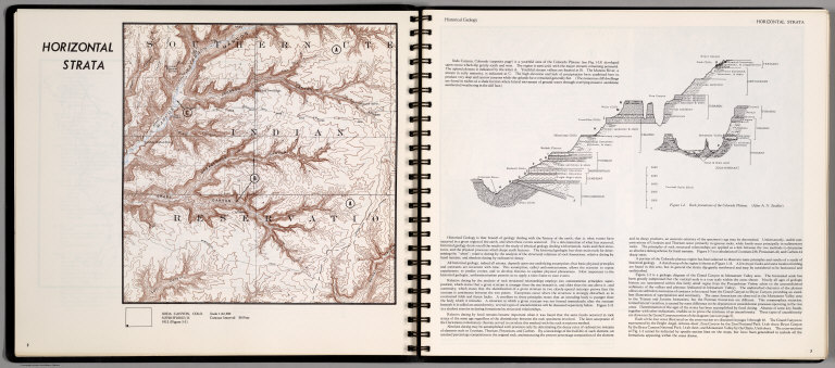
Note
Historical Geology. Contour map, with outline location map. Relief shown by contours and spot height. On the opposite page, text, and cross section of rock formations of the Colorado Plateau. (After A.N. Strahler).
Author
[Scovel, James L., O'Brien, Emmett J]
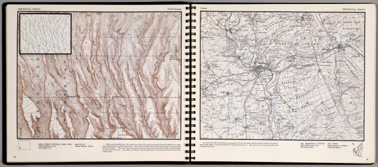
Full Title
Horizontal Strata. Paralle Drainage. Mesa Verde National Park, Colo. (on opposite page) Cuestas. Ste. Menehould, France. 1:50,000.
List No
0889.014
Note
Two contour maps, includes text, and outline location map. Inset on Mesa Verde Nation Park, showing magnified pattern of parallel main streams. Relief shown by contours and spot height.
|