|
REFINE
Browse All : Images of Cincinnati (Ohio)
1-80 of 80
Author
[Ford Motor Company, Geological Survey (U.S.). Topographic Branch]
Full Title
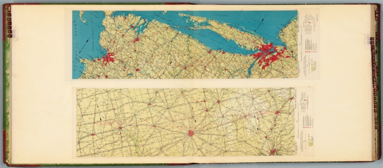
Air navigation map [5] (experimental) : Dayton, Ohio to Rantoul, Ill. Prepared under the direction of the Airways Section Office of the Chief of Air Service by the Topographic Branch, U.S. Geological Survey, 1924. Engineer Reproduction Plant, U.S. Army, Washington Barracks, D.C. 1926, 4915-5. -- Air navigation map no. 6 (experimental) : New York, N.Y. to Boston, Mass. Prepared under the direction of the Airways Section Office of the Chief of Air Corps by the Topographic Branch, U.S. Geological Survey, 1924. Engineer Reproduction Plant, U.S. Army, Washington Barracks, D.C. 4915-6, 1924 - R-1927.
List No
14501.005
Note
Two aeronautical charts representing the areas from Dayton, Ohio to Rantoul, Illinois, and from New York, New York, to Boston, Massachusetts. Features military, municipal, commercial, emergency, and seaplane landing fields, as well as beacon lights. Also shows political boundaries, roads, railways, cities, towns, topography, bodies of water, and drainage. Relief shown with contour lines and color coding. Maps include latitudinal and longitudinal lines, legend, scale statements, and bar scales given in miles, as well as compass roses oriented toward top of sheet (with slight variation between the two maps). Color lithographs. Together, maps are 56 x 92 cm, on double sheet, 60 x 136 cm. Map number 5 provided with a handwritten annotation.
Author
[Ford Motor Company, United States. Army. Air Corps]
Full Title
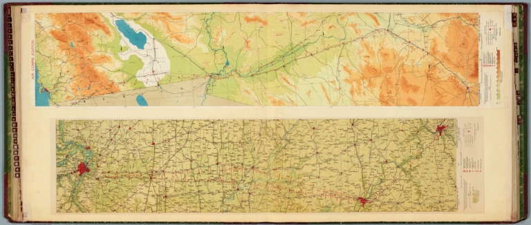
Air navigation map no. 37 (experimental) : Cincinatti, Ohio and Louisville, Ky. to St. Louis, Mo. Compiled and reproduced by the Engineer Reproduction Plant, Corps of Engineers. Under the direction of the Airways Section, Office Chief of Air Corps. 1925. Engineer Reproduction Plant, U.S. Army, Washington Barracks, D.C. 4915. 1926 - R1927. -- Air Corps Edition : Air navigation map no. 38 (experimental) : San Diego, Cal. to Tucson, Ariz. Compiled and reproduced by the Engineer Reproduction Plant, Corps of Engineers. Under the direction of the Airways Section, Office Chief of Air Corps. 1926. Engineer Reproduction Plant, U.S. Army, Washington Barracks, D.C. 6695.
List No
14501.022
Note
Two aeronautical charts representing the areas from Cincinnati, Ohio, and Louisville, Kentucky. to Saint Louis, Missouri, and from San Diego, California, to Tucson, Arizona. Features military, municipal, commercial, emergency, and seaplane landing fields, as well as beacon lights. Also shows political boundaries, roads, railways, cities, towns, topography, bodies of water, drainage, and coastlines. Relief shown with contour lines and color coding. Maps include latitudinal and longitudinal lines, legend, scale statements, and bar scales given in miles, as well as compass roses oriented toward top of sheet (with slight variation between the two maps). Color lithographs. Together, maps are 56 x 130 cm, on double sheet, 60 x 135 cm.
Author
[Ford Motor Company, U.S. Coast and Geodetic Survey]
Full Title
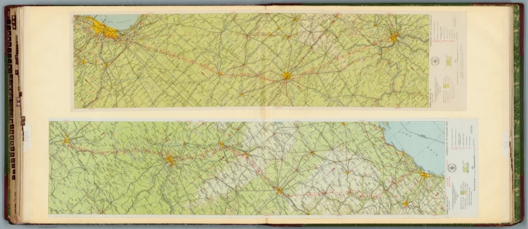
Airway map no. 115 : Louisville Ky to Cleveland Ohio. Compiled and printed for the Aeronautics Branch of the Department of Commerce by the Coast and Geodetic Survey, Washington, D.C. 1929. -- Airway map no. 114 : Cincinnati Ohio to Chicago Ill. Compiled and printed for the Aeronautics Branch of the Department of Commerce by the Coast and Geodetic Survey, Washington, D.C. Jan. 1930.
List No
14501.036
Note
Two aeronautical charts representing the areas from Louisville, Kentucky, to Cleveland, Ohio, and from Cincinnati, Ohio, to Chicago, Illinois. Features military, municipal, and commercial landing fields, seaplane anchorage, beacons, and lighthouse. Also shows political boundaries, roads, railways, cities, towns, topography, bodies of water, drainage, and shorelines. Relief shown with contour lines and color coding. Maps include latitudinal and longitudinal lines, legend, scale statements, and bar scales given in miles, as well as compass roses oriented toward right and left of sheet, respectively. With the seal of the Department of Commerce, United States of America. Color lithographs. Together, maps are 57 x 118 cm, on double sheet, 60 x 135 cm. (Map numbers appear in reverse order: first number 115, followed by number 114.)
Author
Rand McNalley & Company
Full Title
Chicago, and vicinity -- Cincinnati, Ohio -- Columbus, Ohio.
List No
14003.055
Note
3 road maps of cities. Maps include compass roses and legends. Copyright by Rand McNally & Company, Chicago, Ill. Lithographed in the U.S.A.
Author
Colton, G.W.
Full Title
The Cities Of Pittsburgh And Allegheny, With Parts Of Adjacent Boroughs, Pennsylvania. (with) The City Of Cincinnati Ohio. Published By J.H. Colton & Co. No. 172 William St. New York. Entered ... 1855 by J.H. Colton & Co. ... New York. No. 40.
List No
0149.045
Note
In full color by region of the city. A single border encloses the two separate maps.
Author
Colton, G.W.
Full Title
The Cities of Pittsburgh and Allegheny with Part of Adjacent Boroughs Pennsylvania. The City of Cincinnati, Ohio. Published By J. H. Colton. No. 172 William St. New York.
List No
0151.051
Note
The Maps of Cincinnati & Pittsburgh are drawn upon the same scale. Prime Meridian from Washington D. C.
Author
Colton, G.W.
Full Title
The Cities of Pittsburgh and Allegheny with Part of Adjacent Boroughs Pennsylvania. The City of Cincinnati, Ohio. Published By G. W & C. B. Colton & Co. No. 172 William St. New York.
List No
0152.050
Note
The maps of Cincinnati & Pittsburgh are drawn upon the same scale.
Author
[Gray, Frank A., Gray, O.W.]
Full Title
Gray's New Map of Cincinnati by Frank A. Gray. Copyright 1877 by O.W. Gray & Son. (inset) Outline Map of Cincinnati.
List No
0312.034
Author
Mitchell, Samuel Augustus
Full Title
A New Map Of Ohio with its Canals Roads And Distances. (with) Cincinnati. Published By S. Augustus Mitchell, N.E. corner of Market & 7th Street Philada., 1846. Entered ... 1846 by H.N. Burroughs ... Pennsylvania.
List No
0537.029
Note
In full color by county with steamboat route distances shown. Profile of the Ohio Canal included.
Author
Mitchell, Samuel Augustus
Full Title
Plan Of Cincinnati And Vicinity. 32. Entered ... 1860, by S. Augustus Mitchell, Jr. ... Pennsylvania.
List No
0565.022
Note
Full color by numbered area.
Author
Mitchell, Samuel Augustus Jr.
Full Title
Plan of Cincinnati and Vicinity. Entered ... 1867 by S. Augustus Mitchell, Jr. ... Pennsylvania.
List No
0579.033
Note
Color map. Showing roads, railroads, etc.
Author
Mitchell, Samuel Augustus
Full Title
Plan of Cincinnati and vicinity. Entered ... 1879 by S. Augustus Mitchell ... Washington. (1880)
List No
0586.031
Note
Hand colored. Shows wards, major buildings, railroads, etc.
Author
Mitchell, Samuel Augustus Jr.
Full Title
Plan of Cincinnati and vicinity. Copyright by S. Augustus Mitchell 1884.
List No
0592.034
Note
Hand colored. Shows wards, major buildings, railroads, etc.
Full Title
Plan of Cincinnati and vicinity. Copyright 1887 by Wm. M. Bradley & Bro. (1890)
List No
0594.033
Note
Hand colored. Shows wards, major buildings, railroads, etc.
Author
Tanner, Henry S.
Full Title
A New Map Of Ohio with its Canals, Roads & Distances; By H.S. Tanner. (with) Cincinnati. Engraved by E.B. Dawson. Entered ... 1833 by H.S. Tanner ... Pennsylvania. Published by H.S. Tanner, No. 144 Chesnut St. Philadelphia. (above neat line) Tanner's Universal Atlas.
List No
0977.025
Note
Counties delineated by full color. Inset profile of the Ohio Canal from Lake Erie at Cleaveland to Portsmouth. Steamboat distance chart included.
Author
[Passonneau, Joseph R., Wurman, Richard Saul]
Full Title
Cincinnati.
List No
10195.025
Author
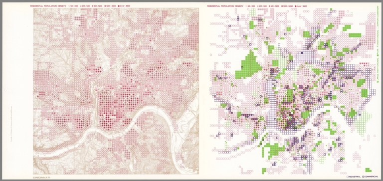
[Passonneau, Joseph R., Wurman, Richard Saul]
Full Title
Cincinnati. Residential Population Density; Industrial, Commercial; Large Institutional, Park, Institutional, Airport, Cemetery.
List No
10195.026
Author
[Passonneau, Joseph R., Wurman, Richard Saul]
Full Title
Cincinnati. Personal Income; Residential Population Density.
List No
10195.027
Author
[Nirenstein, Nathan, Funk & Wagnalls Company.]
Full Title
Nathan Nirenstein's One Hundred Per Cent Business Real Estate Locations, Cincinnati, Ohio.
List No
12508.019
Note
Date estimated.
Author
Petri, Girolamo
Full Title
Tav. CXXVII. Province ecclesiastiche di Baltimora, Cincinnati, e vicariato della Florida.
List No
14007.310
Note
Hand-colored, engraved map showing the ecclesiastical provinces of of Baltimore and Cincinnati, as well as the apostolic vicariates of Florida. With 2 insets: (Michigan) -- (Florida). Text in delicate script circling land. Accompanied by descriptive text on facing page. In Volume III.
Author
Geological Survey (U.S.)
Full Title
Urban areas : Milwaukee, Wis. -- Cleveland, Ohio -- Chicago, Ill. -- Detroit, Mich. -- Pittsburgh, Pa. -- Buffalo, N.Y. -- Cincinnati, Ohio -- Boston, Mass. -- Philadelphia, Pa. -- Atlanta, Ga. -- New Orleans, La. -- Miami, Fla.
List No
14359.035
Note
Twelve maps representing urban areas in the United States, as of 1970. Maps show political boundaries, cities, railways, roads, ferry lines, national forests, mountains, bodies of water, swamps, drainage, coastlines and islands. Relief shown with labeling of mountain names and peak heights. Features population density for each city. Maps include latitudinal and longitudinal lines and scale statements. Colored lithograph. Together, maps are 42 x 65 cm, on double sheet 49 x 71 cm. Index map and legend appear on page 5. Maps appear in General reference maps section.
Author
Cram, George Franklin, 1841-1928
Full Title
Map of Cincinnati.
List No
14372.274
Note
Map of Cincinnati, Ohio. Shows political boundaries, railroads, streets, bridges, parks, bodies of water, drainage, shorelines and islands. Includes a legend. Map indexed to indicate place names, with index at lower right. Colored lithograph. Map is 22 x 29 cm, on sheet 33 x 45 cm.
Author
Colton, G.W.
Full Title
The Cities Of Pittsburgh and Allegheny with Part of Adjacent Boroughs Pennsylvania. The City of Cincinnati, Ohio. Published By G. W & C. B. Colton & Co. ,No. 182 William St. New York.
List No
1550.046
Note
The maps of Cincinnati & Pittsburgh are drawn in the same scale.
Author
[Colton, G.W., Fisher, Richard Swainson]
Full Title
Ohio, Indiana, Kentucky, and Tennessee. (inset) Vicinity of Cincinnati.
List No
1690.102
Note
Relief depicted by hachures.
Author
[Cram, George Franklin, Murray-Aaron, Eugene, 1852-1941.]
Full Title
Cincinnati. Published by George F. Cram, Chicago, Ill. (to accompany) Cram's atlas of the world, ancient and modern : new census edition -- indexed.
List No
1910.077
Note
In full color. Shows city blocks, railroads, roads, public buildings, parks, river, etc. Includes numerical reference to prominent buildings and hotels.
Author
Colton, G.W.
Full Title
The Cities of Pittsburgh and Allegheny. The City of Cincinnati.
List No
2441.092
Note
Two maps on one sheet.
Author
Mitchell, Samuel Augustus
Full Title
Plan of Cincinnati and vicinity. Entered ... 1870, by S. Augustus Mitchell, Jr. ... Pennsylvania.
List No
2483.029
Note
Hand colored. Shows wards, major buildings, railroads, etc.
Author
[Gray, Ormando Willis, Lloyd, H.H., Walling, H. F.]
Full Title
City of Cincinnati, Ohio. 1872. (Published by Stedman, Brown & Lyon, Cincinnati. 1872. Entered ... 1872, by H.F. Walling, and O.W. Gray, and H.H. Lloyd & Co. ... Washington)
List No
2710.009
Note
Hand col. lithographed map. Shows wards, etc.
Author
Rand McNally and Company
Full Title
Cincinnati and Environs.
List No
2790.141
Author
Cram, George Franklin
Full Title
Map of Cincinnati.
List No
2809.097
Note
Includes list of prominent structures, keyed to map.
Author
Rand McNally and Company
Full Title
Rand, McNally & Co.'s Cincinnati and Environs (with) Business Portion of Cincinnati on Enlarged Scale.
List No
2844.041
Author
M. & R. Burgheim (Firm)
Full Title
(Covers to) Map of Cincinnati and suburbs and Covington & Newport. Bellevue, Dayton, Ludlow & Bromley, [Ky]. Entered ... by M. & R Burgheim, Cincinnati, O. ... Washington, D.C. Published by M. & R. Burgheim, Publishers, Importers & Booksellers, 484 Vine Street, corner of Mercer Street, Cincinnati, O. Krebs Lithographing Company, Cincinnati. (1880?)
List No
3370A
Note
Orange cardboard covers printed with "Guide map of Cincinnati and suburbs; also: Covington, Newport, Bellevue, Dayton, Ludlow and Bromley. With a complete street directory, also giving location of all points of interest, hotels, railroad depots, public buildings, theatres, hill-tops, newspapers, &c."
Author
M. & R. Burgheim (Firm)
Full Title
Map of Cincinnati and suburbs and Covington & Newport. Bellevue, Dayton, Ludlow & Bromley, [Ky]. Entered ... by M. & R Burgheim, Cincinnati, O. ... Washington, D.C. Published by M. & R. Burgheim, Publishers, Importers & Booksellers, 484 Vine Street, corner of Mercer Street, Cincinnati, O. Krebs Lithographing Company, Cincinnati. (1880?)
List No
3370.001
Note
Hand col. Shows wards, major buildings, radial distances from court house, etc. Includes (4) p. street directory. David Rumsey Collection copy: "Supplied by Rand McNally & Co. ... New York City" stamped on verso of map.
Author
Rand McNally and Company
Full Title
Rand, McNally & Co.'s indexed atlas of the world map of Cincinnati and environs. Rand, McNally & Co's New business atlas map of Cincinnati. Copyright, 1891 ... Rand, McNally & Co., Engravers, Chicago. (1897)
List No
3565.105
Note
Col. map. Shows major buildings, parks, cemeteries, ferries, etc. Inset: Business portion of Cincinnati on enlarged scale. (Scale ca. 1:11,500). Title in margin: Rand, McNally & Company's indexed atlas of the world.
Author
[Harrison, Robert H., Titus, Clarence O.]
Full Title
(Covers to) Titus' atlas of Hamilton Co., Ohio from actual surveys by R.H. Harrison, C.E. Assisted by Geo. E. Warner, A. Leavenworth, J.E. Sherman, L.C. Warner & R.T. Higgins, to which is added a township map of the state of Ohio. Also an outline & railroad map of the United States. Published by C.O. Titus. 320 Chestnut St., Philadelphia, 1869. Assistants T.F. Pratt, Cyrus Haven, H. Turner, G.P. Stevenson, J.H. Hall, D.B. Titus, G.M. Stevenson. Engd. by Worley & Bracher, 320 Chestnut St., Phila. Printed by F. Bourquin, 320 Chestnut St., Phila. Entered ... 1869 by C.O. Titus ... Pennsylvania.
List No
3748A
Note
The quarter leather dark brown cloth covers are titled "Atlas of Cincinnati and Hamilton Co. Ohio C.O. Titus." in gold.
Author
[Harrison, Robert H., Titus, Clarence O.]
Full Title
(Title Page to) Titus' atlas of Hamilton Co., Ohio from actual surveys by R.H. Harrison, C.E. Assisted by Geo. E. Warner, A. Leavenworth, J.E. Sherman, L.C. Warner & R.T. Higgins, to which is added a township map of the state of Ohio. Also an outline & railroad map of the United States. Published by C.O. Titus. 320 Chestnut St., Philadelphia, 1869. Assistants T.F. Pratt, Cyrus Haven, H. Turner, G.P. Stevenson, J.H. Hall, D.B. Titus, G.M. Stevenson. Engd. by Worley & Bracher, 320 Chestnut St., Phila. Printed by F. Bourquin, 320 Chestnut St., Phila. Entered ... 1869 by C.O. Titus ... Pennsylvania.
List No
3748B
Note
The quarter leather dark brown cloth covers are titled "Atlas of Cincinnati and Hamilton Co. Ohio C.O. Titus." in gold. There are ten detailed maps of Cincinnati. Colton's Ohio map is used without attribution and under Titus' imprint. The plans of towns and counties art typical for the period; no views, except for the last page which has two views and a description of Longview Asylum. Full color.
Author
[Harrison, Robert H., Titus, Clarence O.]
Full Title
(Contents to) Titus' atlas of Hamilton Co., Ohio from actual surveys by R.H. Harrison, C.E. Assisted by Geo. E. Warner, A. Leavenworth, J.E. Sherman, L.C. Warner & R.T. Higgins, to which is added a township map of the state of Ohio. Also an outline & railroad map of the United States. Published by C.O. Titus. 320 Chestnut St., Philadelphia, 1869. Assistants T.F. Pratt, Cyrus Haven, H. Turner, G.P. Stevenson, J.H. Hall, D.B. Titus, G.M. Stevenson. Engd. by Worley & Bracher, 320 Chestnut St., Phila. Printed by F. Bourquin, 320 Chestnut St., Phila. Entered ... 1869 by C.O. Titus ... Pennsylvania.
List No
3748C
Note
Table of contents.
Full Title
Storrs. (with) Cheviot, Green Township. (with) Plainville, Columbia Township. (1869)
List No
3748.009
Note
Hand col. lithographed map with 2 insets. Shows lot numbers, owners of large parcels, buildings, railroads, etc. Includes business directory.
Full Title
Spencer. Madisonville, Columbia Township. (with) Sharpsburg, Columbia Township. (1869)
List No
3748.017
Note
Two hand col. lithographed maps with inset. Show owners of large parcels, sections, roads, railroads, lot numbers, buildings (in Madisonville, Sharpsburg), etc. Includes business directories.
Full Title
Columbia, Spencer Township. (with) Mount Washington. (1869)
List No
3748.018
Note
Hand col. lithographed map with inset. Shows lot numbers, owners of large parcels, buildings, railroad, etc. Includes business directory.
Full Title
Mill Creek. (with) Winton Place. (with) St. Peters, Lick Run, Mill Creek Township, Weaversburg. (1869)
List No
3748.019
Note
Hand col. lithographed map with 2 insets. Shows owners of large parcels, sections, roads, railroads, etc.
Full Title
Corryville, Mill Creek Township (1869)
List No
3748.022
Note
Hand col. lithographed map. Shows block and lot numbers, owners of large parcels, buildings, etc. Includes business directory.
Full Title
Outline map of Cincinnati. Accompanying Atlas of Cincinnati & Hamilton Co. (1869)
List No
3748.028
Note
Hand col. lithographed map. Shows wards, streets, railroads, etc. Includes lists of fire alarm signal boxes and school buildings, and church directory.
Full Title
Cincinnati part I embracing 16th wards. (1869)
List No
3748.029
Note
Hand col. lithographed map. Shows numbers, tracts, owners of large parcels, major buildings, railroads, park, etc.
Full Title
Cincinnati part II embracing 6th, 8th & 15th wards. (1869)
List No
3748.030
Note
Hand col. lithographed map. Shows numbers, tracts, owners of large parcels, major buildings, railroads, etc.
Full Title
Cincinnati part VI embracing 2nd, 4th & 14th wards. (1869)
List No
3748.031
Note
Hand col. lithographed map. Shows numbers, tracts, owners of large parcels, major buildings, railroads, etc.
Full Title
Cincinnati part V embracing 1st & 3d wards. (1869)
List No
3748.032
Note
Hand col. lithographed map. Shows numbers, tracts, owners of large parcels, major buildings, railroads, Cincinnati Observatory, etc.
Full Title
Cincinnati part VI embracing 9th & 13th wards. (1869)
List No
3748.033
Note
Hand col. lithographed map. Shows numbers, tracts, owners of large parcels, major buildings, canal, courthouse, jail, Woodward High School, etc.
Full Title
Cincinnati part VII embracing 17th & part of 20th wards. (1869)
List No
3748.034
Note
Hand col. lithographed map. Shows numbers, tracts, owners of large parcels, major buildings, railroads, etc. David Rumsey Collection copy has annotation in pencil.
Full Title
Cincinnati part VIII embracing part of 20th ward. Cincinnati part III embracing 5th, 7th & 10th wards. (1869)
List No
3748.035
Note
Two hand col. lithographed maps on 1 sheet. Shows numbers, tracts, owners of large parcels, major buildings, canal, etc. David Rumsey Collection copy has annotation in pencil.
Full Title
Cincinnati part IX embracing 11th & 19th wards. (1869)
List No
3748.036
Note
Two hand col. lithographed maps on 1 sheet. Shows numbers, tracts, owners of large parcels, major buildings, etc.
Full Title
Cincinnati part X embracing 12th & 18th wards. (1869)
List No
3748.037
Note
Two hand col. lithographed maps on 1 sheet. Shows numbers, tracts, owners of large parcels, major buildings, railroad, canal, etc.
Full Title
Longview Asylum near Cincinnati, Ohio. Longview Asylum, colored. (1869)
List No
3748.040
Note
Two views surrounded on 3 sides by descriptive text. List of directors and officers at head of text. "The lower cut represents a handsome and convenient edifice which stands on the Carthage Pike, about forty rods west and opposite the main building, and is used for the accommodation of colored patients."
Author
Colton, G.W.
Full Title
The Cities of Pittsburgh and Allegheny ... Pennsylvania. The City of Cincinnati, Ohio.
List No
3800.089
Author
Mitchell, Samuel Augustus Jr.
Full Title
Plan of Cincinnati and vicinity. Entered ... 1874, by S. Augustus Mitchell ... Washington.
List No
3804.033
Note
Hand colored map. Shows wards, railroads, roads, rivers, etc.
Author
[Johnston, Alexander Keith, 1804-1871, Rogers, Henry Darwin]
Full Title
Cincinnati & Vicinity. Louisville Jeffersonville & Vicinity. London ... & according to an act of Congress ... 1857, by H.D. Rogers ... Massachusetts. London, John Murray, Albemarle Street, Edinburgh, W. & A.K. Johnston. Engraved by W. & A.K. Johnston, Edinburgh.
List No
3825.029
Note
Both cites are uncolored with the rivers in blue.
Full Title
Selected industries in twenty principal cities--continued. Based on the returns of the tenth census. 7. Boston, Mass. 8. Cincinnati, Ohio. 9. St. Louis, Mo. 10. Baltimore, Md. 11. Cleveland, Ohio. 12. Newark, N.J. 13. Milwaukee, Wis. 14. San Francisco, Cal. 15. Providence, R.I. 16. Louisville, Ky. 17. Buffalo, N.Y. 18. Washington, D.C. 19. New Orleans, La. 20. Detroit, Mich. Value per capita of the manufactured products of the twenty principal cities of the United States, 1880. Total value of the manufactured products of the twenty principal cities of the United States, 1880. Copyright, 1883, by Charles Scribner's Sons.
List No
4521.137
Note
Uncolored lithographed chart. "Manufactures."
Author
Mitchell, Samuel Augustus Jr.
Full Title
Plan of Cincinnati and vicinity. Entered ... 1876 by S. Augustus Mitchell, . ... Washington.
List No
4564.034
Note
Full color map. Shows wards, major buildings, railroads, etc.
Author
Colton, G.W.
Full Title
The Cities Of Pittsburgh and Allegheny with Part of Adjacent Boroughs Pennsylvania. The City of Cincinnati, Ohio. Published By G. W & C. B. Colton & Co. ,No. 172 William St. New York.
List No
4587.050
Note
The maps of Cincinnati & Pittsburgh are drawn upon the same scale.
Author
[Walling, Henry Francis, 1825-1888, Lloyd, H.H.]
Full Title
Cincinnati. By R.C. Phillips, C.E. Published for Henry S. Stebbins By H.H. Lloyd & Co. New York. (to accompany) Atlas Of The State Of Ohio. 1868.
List No
4726.030
Note
Hand colored map. Shows wards, rivers, canals, bridges, streets and railroads.
Author
Cram, George Franklin
Full Title
Map of Cincinnati.
List No
4727.074
Note
With printed color.
Author
Meyer, Joseph, 1796-1856
Full Title
Neueste Karte von Ohio mit seinen Canaelen, Strassen & Entfernungen der Hauptpunkte. Nach den bessten Quellen verbessert. 1845. (with) Cincinnati. (with) Profil des Ohio Canals. Aus der Geographischen Graviranstalt des Bibliographischen Instituts zu Hildburghausen, Amsterdam, Paris u. Philadelphia, (1860)
List No
4807.158
Note
Engraved map. State boundaries hand col. Includes distance table. Scale of inset map (ca. 1:6,200). "Meyer's Handatlas No. 84." Prime meridians: Ferro and Washington. David Rumsey Collection copy has pencilled annotations.
Author
Colton, G.W.
Full Title
The Cities of Pittsburgh and Allegheny with Parts of Adjacent Boroughs, Pennsylvania. The City of Cincinnati, Ohio. Published by G.W. & C.B. Colton & Co., No. 172 William St. New York.
List No
4825.049
Note
The Maps of Cincinnati & Pittsburgh are drawn upon the same scale.
Author
Mendenhall, Edward
Full Title
(Covers to) Map Of Cincinnati, Newport and Covington. Published By E. Mendenhall At His Map Establishment College Hall. Walnut Street Cincinnati 1860. Middleton Wallace & Co. Lithogrs. Cincinnati. 1860.
List No
4958.001
Note
The second edition. Karrow shows 1855 as the first edition, with issues in 1867 and 1868. A fine map of the city with 34 references to important buildings and a small circular inset map of the vicinity of Cincinnati. Full color. Folded into brown cloth covers 14x9 with "Map Of Cincinnati. E. Mendenhall." stamped in gilt.
Author
Mendenhall, Edward
Full Title
Map Of Cincinnati, Newport and Covington. Published By E. Mendenhall At His Map Establishment College Hall. Walnut Street Cincinnati 1860. Middleton Wallace & Co. Lithogrs. Cincinnati. 1860.
List No
4958.002
Note
The second edition. Karrow shows 1855 as the first edition, with issues in 1867 and 1868. A fine map of the city with 34 references to important buildings and a small circular inset map of the vicinity of Cincinnati. Full color. Folded into brown cloth covers 14x9 with "Map Of Cincinnati. E. Mendenhall." stamped in gilt.
Author
Hayes, Eli L.
Full Title
Upper Ohio River and Valley part XXV, 435 to 451 miles below Pittsburgh, 16 to 32 miles above Cincinnati. (with) California ... (with) Johnsonville ... (with) East Columbia ... (all) Hamilton Co., Ohio. (with) California, Campbell Co., Ky. (... compiled & drawn for the publishers by E.L. Hayes, assisted by E.F. Hayes, C.M. Beresford, assisted by S.A. Charpiot, F.L. Sanford, J.H. Sherman. Published by Titus, Simmons & Titus ... Phila. 1877. Eng. by Worley & Bracher ... Printed by H.J. Toudy & Co. ... Oldach & Mergenthaler Binders ...)
List No
4975.138
Note
Hand col. lithograph with 4 insets. Shows buildings, landowners, townships, etc. Inset maps variously show buildings, lots, landowners, etc; scales (1:4,800)
Author
Hayes, Eli L.
Full Title
Upper Ohio River and Valley part XXVI, 452 to 467 miles below Pittsburgh, from Cincinnati to 15 miles above. (... compiled & drawn for the publishers by E.L. Hayes, assisted by E.F. Hayes, C.M. Beresford, assisted by S.A. Charpiot, F.L. Sanford, J.H. Sherman. Published by Titus, Simmons & Titus ... Phila. 1877. Eng. by Worley & Bracher ... Printed by H.J. Toudy & Co. ... Oldach & Mergenthaler Binders ...)
List No
4975.140
Note
Hand col. lithograph. Shows buildings, landowners, townships, wards, etc.
Author
Hayes, Eli L.
Full Title
Cincinnati, Ohio and vicinity. (... compiled & drawn for the publishers by E.L. Hayes, assisted by E.F. Hayes, C.M. Beresford, assisted by S.A. Charpiot, F.L. Sanford, J.H. Sherman. Published by Titus, Simmons & Titus ... Phila. 1877. Eng. by Worley & Bracher ... Printed by H.J. Toudy & Co. ... Oldach & Mergenthaler Binders ...)
List No
4975.141
Note
Col. lithographed map. Show wards, neighborhoods, etc.
Author
Rand McNally and Company
Full Title
Commercial Atlas of America. Rand McNally 14 x 21 Inch Map of Cleveland and Vicinity. Rand McNally 14 x 21 Inch Map of Cincinnati and Vicinity.
List No
5028.074
Note
Shows railroads, main roads, and key locations. Cleveland map at scale 1:35,000; Cincinnati map at scale 1:33,000.
Author
Mitchell, Samuel Augustus Jr.
Full Title
Plan of Cincinnati. Entered ... 1874 by S. Augustus Mitchell ... Washington.
List No
5041.024
Author
Caldwell, Joseph A.
Full Title
Map of the Pittsburgh, Cincinnati and St. Louis R.R. Pan Handle Route and Principal Connections. Rand Mcnally & Co., Engraver, Chicago. Printed under Patent of January 12, 1875. ( (to accompany) Caldwell's Illustrated, Historical, Centennial Atlas Of Beaver County, Pennsylvania. From actual Surveys by & under the directions of J.A. Caldwell. Assisted by C.T. Arms, Sr. C.E. J.A. Underwood, C.E. J.A. Howden. P.L. Mason. W.J. Kerstetter, C.E. W.F. Arms, C.E. J.J. Power, C.E. Published By J.A. Caldwell, Condit, Ohio. 1876. Engraved, Lithographed & Printed By Otto Krebs, Pittsburgh, Pa.
List No
5043.067
Note
Full color map of the Northeastern United States, showing cities and towns, and the railroad network with named lines. Emphasis on the main lines. Relief shown by hachures.
Author
Caldwell, Joseph A.
Full Title
(Advertisement to) The Great Pan Handle Route. D.W. Caldwell, General Manage, Columbus, Ohio. W.L. O"Brian, General Passenger and Ticket Agent, Columbus, Ohio. ( (to accompany) Caldwell's Illustrated, Historical, Centennial Atlas Of Beaver County, Pennsylvania. From actual Surveys by & under the directions of J.A. Caldwell. Assisted by C.T. Arms, Sr. C.E. J.A. Underwood, C.E. J.A. Howden. P.L. Mason. W.J. Kerstetter, C.E. W.F. Arms, C.E. J.J. Power, C.E. Published By J.A. Caldwell, Condit, Ohio. 1876. Engraved, Lithographed & Printed By Otto Krebs, Pittsburgh, Pa.
List No
5043.068
Note
full page advertisement for "The great Pan Handle Route." Provides the featured routes, connecting North, South, East and West.
Author
Tanner, Henry S.
Full Title
A New Map Of Ohio with its Canals, Roads & Distances; By H.S. Tanner. Engraved by E.B. Dawson. Entered ... 1841 by H.S. Tanner ... Pennsylvania. Published by Carey & Hart Philadelphia. (above neat line) Tanner's Universal Atlas.
List No
5363.029
Note
Counties delineated by full color. Inset profile of the Ohio Canal from Lake Erie at Cleaveland to Portsmouth. Steamboat distance chart included. Inset of Cincinnati. Engraved. Relief shown by hachures. Meridian Washington.
Author
Colton, G.W.
Full Title
The Cities of Pittsburgh and Allegheny with Parts of Adjacent Boroughs, Pennsylvannia. The City of Cincinnati, Ohio. No. 40. Published by J.H. Colton & Co., No 172 William St., New York. Entered according to the Act of Congress in the year 1855 by J.H. Colton & Co. in the Clerk's Office of the District Court of the United States for the Southern District of New York.
List No
5479.082
Note
Two street maps on one sheet. Meridians Washington and Greenwich. Neighborhoods tinted in color.
Full Title
Plan of Cincinnati and vicinity. Copyright 1886 by Wm. M. Bradley & Bro.
List No
5784.033
Note
Hand colored. Shows wards, major buildings, railroads, etc.
Author
Shell Oil Company
Full Title
Shell Map of Metropolitan Cincinnati (cover title). Shell Metropolitan Cincinnati and Vicinity. DD-3-1956-1.
List No
5840.119
Author
Shell Oil Company
Full Title
Downtown Cincinnati. (Verso to) Shell Metropolitan Cincinnati and Vicinity.
List No
5840.120
Author
[Ball, Stuart F., Cincinnati Pictorial Map Company]
Full Title
Historic & pictorial map, Cincinnati, the Queen City. Copyright 1938 by the Cincinnati Pictorial Map Co. Cartography by Stuart F. Ball. A.D. 1938. Litho in U.S.A. by The Progress Lithographic Co. (insets) Cincinnati in 1800. (with) Lookout House. (with) Beverly Hills Country Club. (on verso) Cover title and The Cincinnati Street Railway Co.
List No
8472.003
Note
Colored pictorial map, 44x59 folded into self wrapped cover 22x10. Shows roads, streets, city blocks, buildings, tourist attractions, etc. Includes Code indexes to amusement parks, banks, buildings, cemeteries, churches, etc. On verso: Ancillary map of "Map of Cincinnati public transportation." accompanying tourist information, directory of points of interest, and text on the history of Cincinnati.
Author
Curtis Publishing Company
Full Title
Cincinnati.
List No
9687.032
Author
Rand, McNally & Co.
Full Title
Cincinnati and Environs. Business Portion of Cincinnati.
List No
9733.096
1-80 of 80
|