|
Author
[Sartine, Antoine, Depot de la Marine]
Full Title
Carte Réduite des Côtes Orientales de L'Amérique Septentrionale contenant Celles des Provinces de New-York et de la Nouvelle Angleterre, celles de l'Arcadie ou Nouvelle Ecosse de l'ile St. Jean avec l'intérieur du Pays
List No
15933.003
Author
[Hickmann, Anton Leo, 1834-1906, Fischer, Alois, b. 1894]
Full Title
Nord-Amerika. G. Freytag & Berndt A.G., Wien. (to accompany) Prof. Hickmann's Geographisch-statistischer universal-atlas, 1927.
List No
13687.035
Note
Political map of North America. Showing political boundaries, cities, topography, bodies of water, coastlines, islands. railways, steamship routes and distances. Includes color reference to European possessions. Relief shown by hachures and spot heights. Prime meridian: Greenwich.
Author
Williams, G. Washington
Full Title
Williams' Copper - Plate Map Of The United States, Canada, Mexico, Central America, West Indies, &c. Published by John M. Atwood, 402 Locust Street, Philadelphia. Printed by F. Bourquin, 31 So. 6th Street, Phila. Copyright 1876 by G. Washington Williams.
List No
3030.002
Author
[Lloyd, H.H., Schonberg & Co.]
Full Title
Lloyd's New County Map of the United States And Canadas showing Battle Fields, Railroads, &c. Compiled From The Latest Government Surveys & Other Reliable & Official Sources. Published by H.H. Lloyed & Co. 81 John St. New-York. 1863. Drawn And Engraved By Schonberg & Co., New York. Entered ... 1863, by H.H. Lloyd & Co. ... New York. Published By H.H. Lloyd & Co. ... B.B. Russell, 515 Washington St., Boston, R.R. Landon, 88 Lake St., Chicago ... (inset) California, Oregon And The Territories Of The United States ... (inset) Part Of Florida.
List No
5148.000
Author
Rand McNally and Company
Full Title
Rand McNally & Co.'s New Railroad And County Map Of The United States And Dominion Of Canada. 1882. Rand, McNally & Co., Printers And Engravers, Chicago. Copyright, 1882, by Rand, McNally & Co., Chicago.
List No
4036.000
Author
[Moffat, J., (Fergusson, Adam)]
Full Title
Map Of The British North American Provinces and Adjoining States 1833. Published as the Act directs by W. Blackwood Edinburgh, 1833. Engd. by J. Moffat.
List No
0597.000
Author
Hitchcock, Edward, 1828-1911
Full Title
A geological map of the United States and Canada. 1853. W. C. Sharp's Lith. Boston.
List No
2132.011
Note
Hand-colored, lithographed geologic map of the United States and Canada. Shows political borders, major mountain ranges, drainage , coastlines and islands, as well as geological strata across the North American continent. Relief shown pictorially. Includes latitudinal and longitudinal lines, as well as a legend and a bar scale. Map is 41 x 61 cm, on sheet 45 x 63 cm, folded to 20 x 11 cm. Second of two maps in Hitchock's Geology of the globe.
Author
Rand McNalley & Company
Full Title
(Covers to) Road atlas : Supplement to Rand McNally commercial atlas service. Rand McNally & Company, Publishers, New York, Chicago, San Francisco.
List No
14003.001
Note
Includes "Quick Index" listing states with page numbers. Bound in green paper wrappers. "By issuing the Road Maps in this single volume we are able to give subscribers for the Commercial Atlas Service a complete series (United States, Canada, and Mexico) based on the latest information available at the time of publication."
Author
Rand McNalley & Company
Full Title
Rand McNally road atlas of the United States, Canada and Mexico. Rand McNally & Company, New York, Chicago, San Francisco.
List No
14003.002
Note
Includes Indexes: State and province maps -- City Maps. Table of contents lists: A guide to places of interest -- Mileage map of the United States -- Mileage chart of the United States -- Mileage chart of Mexico -- Motoring in Canada and Mexico. Copyright 1948 by Rand McNally & Company, Chicago. Made in U.S.A.
Author
Vuillemin, Alexandre
Full Title
Geographie commercial et industriel : Nouvelle carte illustree de l'Amerique du Nord : indiquant les grandes divisions physiques, la distribution geographique des vegetaux et des mineraux, les ports de commerce, villes industrielles et fortifiees des differents etats. Dressee par A. Vuillemin. Gravee par Langevin. Paris, Chez Fatout, Editeur. 1857. Grave sur acier, la topographie par Gerin, le trait au burin par F. Lefevre, Les illustrations dessinees par A. Testard et gravees par Guesnu. Imp. par Mangeon. Paris. (to accompany) Atlas de geographie commercial et industriel.
List No
13375.006
Note
Engraved outline hand color map of North America. Includes 14 vignette views of different countries in North America, European colonies, and 2 sections of fruits and plants in panels at sides. Includes tables, legend and notes.
Author
[Pasa, Ali Seref, Esref, Hafiz Ali]
Full Title
Amerika-yi şimali = North America. 1309 (1893). Tabie ve Nnashiri Hasan Ferid. (to accompany) Yeni cografya atlasi - ىگى جغرافىا آطلسى = New geographical atlas. Dersa'adet (Istanbul), 1307-1309 (1891-1893).
List No
13621.008
Note
Map of North America. Covers Central America. Shows political and state boundaries.
Author
Silishchensky, Mitrofan Ivanovich 1878 - 1944
Full Title
Sev. Amer. Soyedinennyye shtaty, Meksika i Yuzhnaya. Kanada : Ekonomicheskaia karta. Prof. M. I. Silishchenskiy. "Geokartprom" Typo-Lithography and M.T. Dunaeva, Moscow. (to accompany) Geograficheskiy atlas Chast 1.
List No
13461.043
Note
Economic map of North. America. Covers part of Central America. Includes legend and tables.
Author
Babson's Statistical Organization, Inc.
Full Title
Babson's map of North America for merchants and bankers : published in connection with Babson's reports on fundamental conditions. Compiling Offices: Welleley Hills, Mass. Copyright 1916, by Babson's Statistical Organization. historic first photo of earth from deep
List No
13667.000
Author
Hall, Sidney
Full Title
British Possessions in North America, with part of the United States, compiled from official sources
List No
10705.000
Note
Date estimated.
Author
American Airlines Inc.
Full Title
Air Map. Route of the flagships uniting Canada, U.S.A. and Mexico. American Airlines Inc.
List No
14038.000
Note
Issued as an advertisement in a magazine, with summary of the air age, and how it applies to our world view. Mankind is no longer dependent on water or land to travel, so those elements are removed from the map. And what you are left with is a totally different take on who your neighbors are. Showing just city names and their approximate distance, it is a new view that would change everything. Date estimated. Map 23 x 23 cm, on sheet 36 x 26 cm. "Reprints of this advertisement available upon request. Address American Airlines, Inc. Dept. 'B.' New York Airport Station, New York." (See Pub List No. 11632.000 for reprint copy.)
Author
[Chatelain Henri, 1684-1743, Gueudeville, Nicolas]
Full Title
Carte de la Nouvelle France, ou se voit le cours des grandes rivieres de S. Laurens & de Mississipi aujour d'hui S. Louis, aux environs des-quelles se trouvent les etats, païs, nations, peuples &c. de la Floride, de la Louisiane, de la Virginie, de la Marie-Lande, de la Pensilvanie, du Nouveau Jersay, de la Nouvelle Yorck, de la Nouv. Angleterre, de l'Acadie, du Canada, des Esquimaux, des Hurons, des Iroquois, des Ilinois &c. et de la grande ile de Terre Neuve : dressee sur les memoires les plus nouveaux recueillis pour l'etablissement de la Compagnie Françoise Occident. Tom. VI. No. 23. Page 90. (to accompany) Atlas Historique ... Tome VI. A Amsterdam, chez L'Honore & Chatelain Libraires. M DCC XIX (1719).
List No
13272.687
Note
Engraved folded map, depiction of the Mississippi Delta and Mobile Bay, based upon the 1699 voyage of Pierre Le Moyne d'Iberville. Shows New England and eastern Canada. Includes plan and views of Quebec in decorative cartouche. Map is filled with engraved wildlife, scenes of Indians hunting, Indian villages, numerous ships, canoes and sea monsters and notations.
Author
Lapie, Pierre
Full Title
A map of the United States and Canada, New-Scotland, New-Brunswick and New-Foundland = Carte des Etats-Unis avec le Canada, la Nouvelle Ecosse, le Nouveau Brunswick & Terre-Neuve. Dressee par Lapie. Publiee par Auguste Logerot. Paris. Mangeon imp. Paris.
List No
13398.002
Author
Vuillemin, Alexandre
Full Title
Geographie commerciale et industrielle : Nouvelle carte illustree de l'Amerique du Nord : Indiquant Les Grandes Divisions Physiques, La Distribution Geographique Des Vegetaux Et Mineraux ... Dressee par A. Vuillemin. Gravee par Langevin. Paris, Chez Fatout, Editeur. 1861. Grave sur acier, Grave: la Topographie par Gerin, le trait au burin par F. Lefevre. Les illustrations dessinees par A. Testard et gravees par Guensu. Imprime par Mangeon. Paris. (to accompany) Atlas illustre de geographie commerciale et industrielle.
List No
13376.019
Note
Engraved outline hand color map. Including 16 vignettes views showing indigenous people in North America and 2 sections of fruits and plants in panels at sides. Map shows Russian America, Utah & New Mexico extending to the Rocky Mountains, Oregon, Northwest and Indian Territories, early discoveries, including a reference to Alvaro Nunez in Texas in 1528, Cabrillo's discovery of the Pacific in 1548, Francis Drake, Lewis & Clark and Edwin James. Includes legend, tables, color coded table of European colonies in the region and notes.
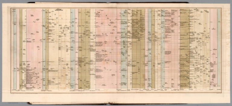
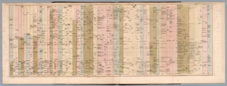
Author
Holgate, Jerome B., 1812-1893
Full Title
(Timeline chart). Engraved by G.W. Boynton. Entered according to Act of Congress in the year one thousand eight hundred and forty-two, by Jerome B. Holgate ... Massachusetts. (to accompany) Atlas of American history on a novel plan ... By Jerome B. Holgate. 1842.
List No
13300.008
Note
Engraved timeline chart, 1402- 1598.
Author
Holgate, Jerome B., 1812-1893
Full Title
(Timeline chart). G.W. Boynton, Sc. Entered according to Act of Congress in the year one thousand eight hundred and forty-two, by Jerome B. Holgate ... Massachusetts. (to accompany) Atlas of American history on a novel plan ... By Jerome B. Holgate. 1842.
List No
13300.009
Note
Engraved timeline chart, 1602-1672.
Author
Holgate, Jerome B., 1812-1893
Full Title
(Timeline chart). G.W. Boynton, Sc. Entered according to Act of Congress in the year one thousand eight hundred and forty-two, by Jerome B. Holgate ... Massachusetts. (to accompany) Atlas of American history on a novel plan ... By Jerome B. Holgate. 1842.
List No
13300.010
Note
Engraved timeline chart, 1673-1721.
Author
Holgate, Jerome B., 1812-1893
Full Title
(Timeline chart). G.W. Boynton, Sc. Entered according to Act of Congress in the year one thousand eight hundred and forty-two, by Jerome B. Holgate ... Massachusetts. (to accompany) Atlas of American history on a novel plan ... By Jerome B. Holgate. 1842.
List No
13300.011
Note
Engraved timeline chart, 1724-1763.
Author
Holgate, Jerome B., 1812-1893
Full Title
(Timeline chart). Engraved by G.W. Boynton. Entered according to Act of Congress in the year one thousand eight hundred and forty-two, by Jerome B. Holgate ... Massachusetts. (to accompany) Atlas of American history on a novel plan ... By Jerome B. Holgate. 1842.
List No
13300.012
Note
Engraved folded timeline chart, 1764-1782.
Author
Holgate, Jerome B., 1812-1893
Full Title
(Timeline chart). Engraved by G.W. Boynton. Entered according to Act of Congress in the year one thousand eight hundred and forty-two, by Jerome B. Holgate ... Massachusetts. (to accompany) Atlas of American history on a novel plan ... By Jerome B. Holgate. 1842.
List No
13300.013
Note
Engraved folded timeline chart, 1797-1841.
Author
Clason Map Company
Full Title
(Covers to) Clason's Touring Atlas Of The United States And Canada. An Accurate Guide to the best roads of every state. Featuring 40 Large Maps Revised Annually. Showing the Latest Paving and Surfacing in Every State. New Census Figures f or Populations of Cities and Towns. Published by Clason Map Company. General Office 1525 Tremont Place, Denver, Colo. Copyrighted, 1931. The Clason Map Co.
List No
4423.001
Author
Clason Map Company
Full Title
(Title Page to) Clason's Touring Atlas Of The United States And Canada. An Accurate Guide to the best roads of every state. Featuring 40 Large Maps Revised Annually. Showing the Latest Paving and Surfacing in Every State. New Census Figures f or Populations of Cities and Towns. Published by Clason Map Company. General Office 1525 Tremont Place, Denver, Colo. Copyrighted, 1931. The Clason Map Co.
List No
4423.002
Author
Clason Map Company
Full Title
In and out maps of the principal cities showing highway connections. ( Continued on page 49). Copyright by Clason Map Co. Denver.
List No
4423.003
Note
48 uncolored maps. (continued on page 49). showing roads and highway connections in major cities in the United States.
Author
Clason Map Company
Full Title
(Text Page to) Touring Atlas of the United States and Canada. Published and Copyrighted by: The Clason Map Company, General Office, Denver, Colorado.
List No
4423.004
Note
This page includes: Tables of distances; Alphabetical lists of speed limits, and states registration for visiting motorist; and Index of maps.
Author
[Brion de La Tour, Louis, 1743 – 1803, Desnos, Louis Charles]
Full Title
Nouveau Mexique, Louisiane, Canada, et les Etats Unis. Par M. Brion. A Paris, chez le Sr. Desnos. A.P.D.R. 1786. (to accompany) Atlas general, civil, ecclesiastique et militaire, methodique et elementaire pour l'etude de la geographie et de l'histoire ... par M. Brion, dirige par le sr. Desnos … A Paris 1786.
List No
13129.057
Note
Engraved hand color map. Two long rivers run from California to the Rocky Mountain region. Shows American Indian settlements. Louisiana is divided into two regions, Floride, which contains all of the territory between the appellations and the Mississippi, and Louisiana proper. Relief shown pictorially. Includes note regarding explorations along the Northwest Coast of America. Includes decorative engraved title cartouche and border.
Author
Lloyd, James T.
Full Title
Lloyd's New Map of the United States, the Canadas and New Brunswick, From the latest Surveys showing every Railroad & Station Finished to June 1864, and the Atlantic and Gulf Coasts.
List No
12387.001
Note
Color. Has a pasted-in sheet which provides a legend relating to map colors and areas of Unioin and Confederate control in the American Civil War as of October 4, 1864. Also includes a note warning customers of a substandard series of maps being sold under the brand "Lloyd's Maps".
Author
Aa, Pieter van der, 1659-1733
Full Title
L'Amerique septentrionale, Suivant les nouvelles observations de Messrs ... A Leide, Chez Pierre Van der Aa. (to accompany) Nouvel Atlas, tres-exact et fort commode pour toutes sortes de personnes, Contenant les Principales Cartes Geographiques ...
List No
11691.101
Note
Full color map of North America and the West Indies. Centered on the Great lakes, covers from Baffin Bay to the Amerique Meridionale, including Florida, New Mexico, New Spain (Mexico), California, Nouvelle France, and the Hudson Bay. California is not clear whether it is an island or not. The Gulf of California is left open ended, Parts of California are identified as New Albion. The exploration routes used by d'Oliver, Cortez, and Drake are shown in dote lines to the west of Mexico. Map showing political and administrative boundaries and settlements. Relief shown pictorially. Includes decorative title cartouche.
Author
American Airlines Inc.
Full Title
Air Map. Route of the flagships uniting Canada, U.S.A. and Mexico. American Airlines Inc.
List No
11632.000
Note
Issued first as an advertisement, with summary of the air age, and how it applies to our world view. Mankind is no longer dependent on water or land to travel, so they are removed from the map. And what you are left with is a totally different take on who your neighbors are. Showing just city names and their approximate distance, it is a new view that would change everything. Date estimated.
Author
Moll, Herman, d. 1732
Full Title
A New and Exact Map of the Dominions of the King of Great Britain on ye Continent of North America. (insets) Carolina, Louisiana, Florida. Carolina. Charles-town. North America. Beaver activity illustration.
List No
9729.010
Note
State 6 of this map. Known as the "Beaver map" because of its depiction of beavers at work building dams with Niagara Falls in the background. This map at the time was the most detailed and largest scale map of British possessions in North America. First issued in 1715, the map went through 7 different issues to 1736.
Author
New England Railway Publishing Company
Full Title
ABC The Pathfinder Railway Guide Map, Western Section. (insets) Alaska. Yellowstone Park. Philippine Islands. Hawaiian Islands.
List No
9060.000
Author
[Seutter, Matthaeus, 1678-1756, Rogg, Gottfried, 1669-1742]
Full Title
Accurata delineatio celeberrimae Regionis Ludovicianae vel Gallice Louisiane ol. Canadae et Floridae Adpellatione in Septemtrionali America Descriptae quae Hodie Nomine Fluminis Mississippi vel St. Louis . . . edita cura et manu Matthaei Seutteri, Chalcog. Augustan. ; Gottfr. Rogg, del. M. Rhein, sc.(inset) "Les costes de la Louisiane depuis la baye de Ascension jusques acelle de S. Joseph.
List No
8155.000
Note
Hand colored map of Seutter's Mississippi Bubble map, depicting the short-lived French financial-colonial scheme masterminded by Scottish financier John Law. Map shows early eighteenth century geography, settlements, and territories in North America focusing on the Mississippi River and the Great Lakes. Relief shown pictorially. Includes historical notes and distant chart. A large inset of the Gulf Coast shows many forts and Indian villages. Elaborate title cartouche, depicts an allegorical, satirical scene of the infamous Mississippi Bubble investment scheme with a female personification of the Mississippi River pouring jewels and riches forth, while she is perched precariously upon a bubble. Cherubs above the cartouche are issuing stock for the company, and another group is blowing bubbles in the foreground surrounded by piles of worthless stocks. In the background, desperate investors climb a small tree and fling themselves out of it, and in the foreground more disconsolate investors wail and bemoan their fates as one tries to impale himself on his sword. Above them, a cherub upends an empty money-bag.
Author
Gallatin, Albert
Full Title
Carte des Tribus Indiennnes de l'Amerique du Nord : vers 1600 A.D. ;e long de l'Atlantique ; et vers 1800 A.D. a l'Ouest. D'apres un dessin Mr. Gallatin.
List No
6749.000
Note
Map of the Indian Tribes of North America about 1600 A.D. along the Atlantic; & about 1800 A.D. westwardly. This edition is identical to the American edition of Gallatin map (see: Rumsey Historical Map Collection #3388.000), published by the American Antiquarian Society in their Archaeologia Americana, 1838, except for the addition of an area in the middle of map with a double broken line, showing Indian Territory in Oklahoma. "Le Terrotoire definitivement attribue aux Indiens, est indique par le double trail noir pointle." Map is hand colored. Includes color code listing of Indian territories and tribes, rivers, mountains, place names and notes. Great Basin is called "Sandy Desert". Shows J. Smith exploration routes of 1826 and 1827 across the Great Basin. Date estimated.
Author
[Pownall, Thomas, 1722-1805, Evans, Lewis, 1700?-1756, Almon, John, 1737-1805, Turner, James, d. 1759, Gist, Christopher, d. 1750]
Full Title
A Map of the Middle British Colonies in North America. First Published by Mr. Lewis Evans, of Philadelphia, in 1755; and since corrected and improved, as also extended with the addition of New England, and bordering Parts of Canada; from actual Surveys now lying at the Board of trade. By T. Pownall MP. Engraved by Jas. Turner in Philadelphia.
List No
6901.002
Note
This is a revised and expanded edition of Lewis Evans' 1755 "Map of the Middle British Colonies in North America." <a href=http://www.davidrumsey.com/luna/servlet/s/7y22vy target=_blank>See in Pownall's "Topographical Description"</a>
Author
[Mitchell, John, Raynal, G.T., Zatta, Antonio]
Full Title
(Title Page to) Storia Dell' America Settentrionale Del Signor Abate Raynal Continuata fino al present, con Carte Geografiche rappresentanti il Teatro della Guerra Civile tra la Gran Bretagna, e le Colonie Unite. A SS. EE. Li Signori Rifoormatori Dello Studio Di Padova. In Venezia, Dalle Stampe Di Antonio Zatta Con Licenza De Superiori, E Privilegio. M. DCC. LXXVIII.
List No
5007A
Note
In addition to a two volume Italian translation of Raynal's History of North America, this book contains the first edition of Zatta's twelve sheet version of Mitchell's Map of North America, plus three other maps: Il Canada, Le Isole di Terra Nuova e Capo Breton, and La Baja D' Hudson. All of these maps appeared also in Zatta's Atlante Novissimo published from 1779-1785. A second edition of the Zatta/Mitchell maps was published in 1791 (see P651). Zatta's version of Mitchell is not an exact or complete copy: the Zatta maps do not cover the far western portions of Mitchell's map, many geographical changes are introduced, and Bermuda is depicted as well as Jamaica., neither of which are shown by Mitchell. A separate map covers Newfoundland and Cape Breton, on the same scale. Maps are hand painted with outline color. Covers are quarter leather light brown marbled paper covered boards with "Raynal. Storia Dell' America Settentrionale. 1778" stamped in gilt on the new leather spine.
Author
[Mitchell, John, Raynal, G.T., Zatta, Antonio]
Full Title
Il Canada, Le Colonie Inglesi Con La Luigiana, e Florida. di nuova Projezione. Venezia 1778. Presso Antonio Zatta Con Privilegio dell'Eccmo Senato. G. Zuliani inc.
List No
5007.002
Note
In outline color with map spanning the continent from Canada to Florida and to Louisiana in the west.
Author
Alaskan Boundary Tribunal
Full Title
(Covers to) Alaskan Boundary Tribunal. (Volume 1) British Atlas. Maps And Charts Accompanying The Case Of Great Britain. Washington, Government Printing Office, 1904.
List No
0009.001
Note
Bound in half leather red cloth covered boards. Covers are stamped in gold with titles followed by "John J. Esch", owner of this set.
Author
Alaskan Boundary Tribunal
Full Title
(Title Page to) Alaskan Boundary Tribunal. (Volume 1) British Atlas. Maps And Charts Accompanying The Case Of Great Britain. Washington, Government Printing Office, 1904. (Pasted in: Senate Document No. 162, 58th Congress, 2d Session).
List No
0009.002
Author
Alaskan Boundary Tribunal
Full Title
(Table of Contents to) Alaskan Boundary Tribunal. (Volume 1) British Atlas. Maps And Charts Accompanying The Case Of Great Britain. Washington, Government Printing Office, 1904.
List No
0009.003
Note
Lists 37 map sheets.
Author
[Alaskan Boundary Tribunal, Vancouver, George]
Full Title
(Facsimile) A Chart Shewing Part of the Coast of N.W. America with Tracks of his Majesty's Sloop Discovery and Armed Tender Chatham .... Published May 1st, 1798 by J. Edwards, Pall Mall & G. Robinson, Paternoster Row.
List No
0009.004
Note
Surveyed during summers of 1782, 1783, and 1784. British names assigned to various reaches of coastline such as "New Norfolk" and "New Hanover." Delineates between Spanish and Russian possessions. Relief shown by sketches.
Author
[Alaskan Boundary Tribunal, Vancouver, George]
Full Title
(Facsimile) From Vancouvers Atlas - Part of Chart No. XII; Part of Chart No. VII. Photo. Lith. by A. Hoen & Co., Baltimore, MD.
List No
0009.005
Note
See Table of Contents which itemizes the two Vancouver maps omitted here because they are included as maps numbered No. 4 and No. 5 in the U.S. part of this atlas. Relief shown by sketches. Relief shown by sketches.
Author
Alaskan Boundary Tribunal
Full Title
(Facsimile) Russian Map (Enclosure in C. Bagot's Dispatch). Translation of Title: Map of Marine Discoveries by Russian Navigators in the Pacific and Frozen Oceans, made in various years.
List No
0009.006
Note
In Russian. Relief shown by sketches.
Author
Alaskan Boundary Tribunal
Full Title
(Facsimile) (Russian Map) Part of Map Numbered 5.
List No
0009.007
Note
In Russian. Relief shown by sketches. Boundaries tinted.
Author
[Alaskan Boundary Tribunal, Von Langsdorff, G.H.]
Full Title
(Facsimile) Map of the World Illustrating the Voyages and Travels of G.H. Von Langsdorff. Photo. Lith. by A. Hoen & Co. Baltimore MD. London, Published Feby. 1st. 1814 by Henry Colburn, Conduit Street. Thompson & Hall sculpt. 14 Bury Strt., Bloomsby.
List No
0009.008
Author
[Arrowsmith, Aaron, Alaskan Boundary Tribunal]
Full Title
(Facsimile) Map of America (northwest portion) by A. Arrowsmith, Hydrographer to His Majesty, 1822. Additions to 1824.
List No
0009.009
Note
Tinted boundaries. Relief shown by hachures.
Author
[Alaskan Boundary Tribunal, Arrowsmith]
Full Title
(Facsimile) (Arrowsmith's America - northwestern portion). Photo. Lith. by A. Hoen & Co. Baltimore, MD.
List No
0009.010
Note
Relief shown by hachures.
Author
[Faden, William, 1750?-1836, Alaskan Boundary Tribunal]
Full Title
(Facsimile) Map of North America (portion) from 20 to 80 Degrees North Latitude Exhibiting the recent Discoveries, Geographical and Nautical; Drawn chiefly from the Authorities M. de Humbolt (Humboldt), Lieut; Pike. Mess. Lewis and Clarke. Sir Alexr. Mackenzie. Mr. Hearne, Col. Bouchette, Capt. Vancouver, Ross, Parry & Franklin also Describing the Boundary Lines between the Territories of Great Britain & Spain with the United States. London. Published by Ja. Wyld (successor to W. Faden) N.5. Charing Cross, Geographer to His Majesty and to H.R.H. the Duke of York, June 1, 1823. Photo. Lith. by A. Hoen & Co. Baltimore, MD. (by Faden).
List No
0009.011
Note
Tinted coastline. Relief shown by hachures.
|