|
Author
[Whitney, J.D., Watkins, C.E.]
Full Title
(View) The North Dome.
List No
5949.018
Author
[Whitney, J.D., Watkins, C.E.]
Full Title
(View) The Half Dome.
List No
5949.019
Author
[Whitney, J.D., Watkins, C.E.]
Full Title
(View) View Up the Canyon of the Illilouette.
List No
5949.020
Note
This photograph is improperly labeled; it was taken from the Valley floor looking east with Glacier Point on the right and Liberty Cap on the left in the distance. Illilouette Canyon is tucked around out-of-sight to the right.
Author
[Whitney, J.D., Watkins, C.E.]
Full Title
(View) The Vernal Fall.
List No
5949.021
Author
[Whitney, J.D., Watkins, C.E.]
Full Title
(View) The Nevada Fall and the Cap of Liberty.
List No
5949.022
Author
[Whitney, J.D., Watkins, C.E.]
Full Title
(View) The Nevada Fall, near View.
List No
5949.023
Author
[Whitney, J.D., Watkins, C.E.]
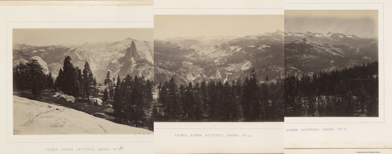
Full Title
(View) Views from Sentinel Dome No. 1.
List No
5949.024
Author
[Whitney, J.D., Watkins, C.E.]
Full Title
(View) Views from Sentinel Dome No. 2.
List No
5949.025
Author
[Whitney, J.D., Watkins, C.E.]
Full Title
(View) Views from Sentinel Dome No. 3.
List No
5949.026
Author
[Whitney, J.D., Watkins, C.E.]
Full Title
(Composite) [Views from Sentinel Dome Nos. 1, 2, 3.; Photographs Nos. 19, 20, and 21.]
List No
5949.027
Author
[Whitney, J.D., Watkins, C.E.]
Full Title
(View) View Looking towards the Nevada and Merced Falls, from Glacier Point.
List No
5949.028
Author
[Whitney, J.D., Watkins, C.E.]
Full Title
(View) The Grizzly Giant, Mariposa Grove.
List No
5949.029
Author
[Whitney, J.D., Watkins, C.E.]
Full Title
(View) Base of the Grizzly Giant.
List No
5949.030
Note
Galen Clark, the Guardian of Yosemite, is posed in front of the Grizzly Giant.
Author
[Whitney, J.D., Harris, W.]
Full Title
(View) Summit of Mt. Hoffmann.
List No
5949.031
Author
[Whitney, J.D., Harris, W.]
Full Title
(View) Lake Tenaya.
List No
5949.032
Author
[Whitney, J.D., Harris, W.]
Full Title
(View) Cathedral Peak, from Soda Springs.
List No
5949.033
Author
[Whitney, J.D., Harris, W.]
Full Title
(View) Valley of Mr. Lyell, Fork of the Upper Tuolumne.
List No
5949.034
Author
[Whitney, J.D., Gardner, J.T., Hoffmann, Chs. F.]
Full Title
Map of a Portion of the Sierra Nevada adjacent to Yosemite Valley, from surveys made by Chs. F. Hoffmann and J.T. Gardner, 1863, 1867. Geological Survey of Califoria, J.D. Whitney, State Geologist.
List No
5949.036
Note
Relief depicted as hachures. Shows trails. Tioga Pass shown as McLane's Pass.
Author
[King, Clarence, Gardner, J.T.]
Full Title
Map of the Yosemite Valley from Surveys made by order of the Commissioners to manage the Yosemite Valley and Mariposa Big Tree Grove by C. King and J.T. Gardner 1865. Drawn by J.T.G.
List No
5950.000
Note
Date based upon the contents matching map of 1870 publication date, see our Image No. 5901019. Probably published by Julius Bien of New York. Relief shown by hachures. Flat map on heavy paper stock. Original is owned by James B. Snyder. Compared with previous edition, our Image No. 5905000, this has many additions: "Washburn & Macready" building; "Little Yosemite Valley"; "Snow" building; Vernal Falls trail; "Ladders" added at Vernal Falls; "Boat House"; "Winter" added to "Lamon's Hs."; "Summer" added to Lamon's Hs."; "Saw Mill"; trail to top of Yosemite Falls via Indian Valley; trail past base of Three Brothers; "Store"; "Laundry"; "Black's Hotel"; Leidig's Hs. Winter"; "Leidig & Davaney's Hotel"; "Bridge" (replaced "Ferry"); "Trail to Glacier Point"; Trail from Peregoy's"; "Gentry's". Removed from previous edition is "Ladders" from where it was placed next to "Bridge" above Vernal Fall; trace of erasure is visible.
Author
H.M. Gousha Company
Full Title
(Covers to) California Points of interest and touring map. (insets) Enlarged map of the Los Angeles District, Map key and mileage chart, and California Mileage Chart. (on verso) Road map of California. Prepared for Standard Oil Company of California. Scale 1 inch equals approximately 21 miles. Copyright 1956 by The H.M. Goushá Company Chicago, San Jose. Lithographed in U.S.A. (insets) Road map of United States, Map key and mileage chart, Enlarged Map of the San Francisco District.
List No
5951.001
Note
Color map, printed on both sides, folded to 23x10 cm, bears the Chevron logo on both sides, and a complete legend and date of publication. With full color view of Vernal Falls Yosemite (on cover). Copyright and lithography by H.M. Gousha Company, Chicago-San Jose. Relief shown by hachures and spot heights. State map includes an index with population and keyed list of cities and towns. Useful information as mileage charts (distances between cities), speed limits, highway safety pointers, state traffic rules, text and illustrations. National map includes mileage, driving times between destinations, and list of National parks and monuments.
Author
H.M. Gousha Company
Full Title
(North half) Road map of California. Prepared for Standard Oil Company of California. Scale 1 inch equals approximately 21 miles. Copyright 1956 by The H.M. Goushá Company Chicago, San Jose. Lithographed in U.S.A. (insets) Road map of United States, Map key and mileage chart, and Enlarged Map of the San Francisco District. (on verso panel title) California Points of interest and touring map. (insets) Enlarged map of the Los Angeles District, Map key and mileage chart, and California Mileage Chart.
List No
5951.002
Note
Color map, printed on both sides, folded to 23x10 cm, bears the Chevron logo on both sides, and a complete legend and date of publication. With full color view of Vernal Falls Yosemite (on cover). Copyright and lithography by H.M. Gousha Company, Chicago-San Jose. Relief shown by hachures and spot heights. State map includes an index with population and keyed list of cities and towns. Useful information as mileage charts (distances between cities), speed limits, highway safety pointers, state traffic rules, text and illustrations. National map includes mileage, driving times between destinations, and list of National parks and monuments.
Author
H.M. Gousha Company
Full Title
(South half) Road map of California. Prepared for Standard Oil Company of California. Scale 1 inch equals approximately 21 miles. Copyright 1956 by The H.M. Goushá Company Chicago, San Jose. Lithographed in U.S.A. (insets) Road map of United States, Map key and mileage chart, and Enlarged Map of the San Francisco District. (on verso panel title) California Points of interest and touring map. (insets) Enlarged map of the Los Angeles District, Map key and mileage chart, and California Mileage Chart.
List No
5951.003
Note
Color map, printed on both sides, folded to 23x10 cm, bears the Chevron logo on both sides, and a complete legend and date of publication. With full color view of Vernal Falls Yosemite (on cover). Copyright and lithography by H.M. Gousha Company, Chicago-San Jose. Relief shown by hachures and spot heights. State map includes an index with population and keyed list of cities and towns. Useful information as mileage charts (distances between cities), speed limits, highway safety pointers, state traffic rules, text and illustrations. National map includes mileage, driving times between destinations, and list of National parks and monuments.
Author
H.M. Gousha Company
Full Title
Road map of United States,
List No
5951.004
Note
Color map, printed on both sides, folded to 23x10 cm, bears the Chevron logo on both sides, and a complete legend and date of publication. With full color view of Vernal Falls Yosemite (on cover). Copyright and lithography by H.M. Gousha Company, Chicago-San Jose. Relief shown by hachures and spot heights. State map includes an index with population and keyed list of cities and towns. Useful information as mileage charts (distances between cities), speed limits, highway safety pointers, state traffic rules, text and illustrations. National map includes mileage, driving times between destinations, and list of National parks and monuments.
Author
[H.M. Gousha Company, Tide Water Associated Oil Company]
Full Title
(Covers to) Street map of San Francisco. 1 inch = about six-tenths miles. Copyright by The H.M. Goushá Company Chicago, San Jose. Lithographed in U.S.A. ((inset) Downtown San Francisco. (onverso) San Francisco Bay Region and Adjacent Area. (prepared for) Flying A Ethyl Gasoline. Scale--one inch equals approx. 4 1/2 miles. Copyright by The H.M. Goushá Company Chicago, San Jose. Lithographed in U.S.A. by Schwabacher-Frey. (with panel title) Let's get associated, San Francisco and Bay Region. Flying "A" Service. Tide Water Associated oil Company.
List No
5952.001
Note
Two maps on one sheet, printed on both sides, color, folded to 23x10 cm. With indexes to San Francisco Bay Region and adjacent area cities and towns, and streets of San Francisco and adjoining peninsula area. Includes text, mileage chart, advertisements, and advertisements. Relief shown by hachures, shadings and spot heights.
Author
[H.M. Gousha Company, Tide Water Associated Oil Company]
Full Title
Street map of San Francisco. 1 inch = about six-tenths miles. Copyright by The H.M. Goushá Company Chicago, San Jose. Lithographed in U.S.A. ((inset) Downtown San Francisco. (onverso) San Francisco Bay Region and Adjacent Area. (prepared for) Flying A Ethyl Gasoline. Scale--one inch equals approx. 4 1/2 miles. Copyright by The H.M. Goushá Company Chicago, San Jose. Lithographed in U.S.A. by Schwabacher-Frey. (with panel title) Let's get associated, San Francisco and Bay Region. Flying "A" Service. Tide Water Associated oil Company.
List No
5952.002
Note
Two maps on one sheet, printed on both sides, color, folded to 23x10 cm. With indexes to San Francisco Bay Region and adjacent area cities and towns, and streets of San Francisco and adjoining peninsula area. Includes text, mileage chart, advertisements, and advertisements. Relief shown by hachures, shadings and spot heights.
Author
[H.M. Gousha Company, Tide Water Associated Oil Company]
Full Title
San Francisco Bay Region and Adjacent Area. (prepared for) Flying A Ethyl Gasoline. Scale--one inch equals approx. 4 1/2 miles. Copyright by The H.M. Goushá Company Chicago, San Jose. Lithographed in U.S.A. by Schwabacher-Frey. (with panel title) Let's get associated, San Francisco and Bay Region. Flying "A" Service. Tide Water Associated oil Company. (on verso) Street map of San Francisco. 1 inch = about six-tenths miles. Copyright by The H.M. Goushá Company Chicago, San Jose. Lithographed in U.S.A. ((inset) Downtown San Francisco.
List No
5952.003
Note
Two maps on one sheet, printed on both sides, color, folded to 23x10 cm. With indexes to San Francisco Bay Region and adjacent area cities and towns, and streets of San Francisco and adjoining peninsula area. Includes text, mileage chart, advertisements, and advertisements. Relief shown by hachures, shadings and spot heights.
Author
[State Farm Insurance Companies Travel Bureau, Rand McNally and Company]
Full Title
Rand McNally Road map, California. Copyright by Rand McNally & Company, Chicago, Ill. Lithographed in the U.S.A. (to accompany) State Farm Road Atlas: United States, Canada, Mexico,Central and South America. Copyright 1940 by Rand McNally & Company, Chicago, Ill.
List No
5969.022
Note
Color map. U.S. interstate highways shown in red. Shows roads, capitals, population of cities and towns, etc. Relief shown by hacures and spot heights.
Author
[USGS (U.S. Geological Survey), Walcott, Charles D., Thompson, A.H., Sudworth, George B., Gannett, Henry]
Full Title
Plate LXXXV. Placerville Quadrangle, Land Classification and Density of Standing Timber.
List No
6322.117
Note
Color. Relief shown in contours.
Author
[USGS (U.S. Geological Survey), Walcott, Charles D., Gannett, Henry, Sudworth, George B.]
Full Title
Plate LXXXVI. Pyramid Peak Quadrangle, Land Classification and Density of Standing Timber. Julius Bien & Co. Lith. N.Y.
List No
6322.118
Note
Color. Relief shown in contours.
Author
[USGS (U.S. Geological Survey), Walcott, Charles D., Sudworth, George B.]
Full Title
Plate LXXXVII. Jackson Quadrangle, Land Classification and Density of Standing Timber. Julius Bien & Co. Lith. N.Y.
List No
6322.119
Note
Color. Relief shown in contours.
Author
[USGS (U.S. Geological Survey), Walcott, Charles D., Sudworth, George B.]
Full Title
Plate LXXXVIII. Big Trees Quadrangle, California. Land Classification and Density of Standing Timber.
List No
6322.120
Note
Color. Relief shown in contours.
Author
[USGS (U.S. Geological Survey), Walcott, Charles D., Sudworth, George B.]
Full Title
Plate LXXXIX. Markleeville Quadrangle, California. Land Classification and Density of Standing Timber. Julius Bien & Co. Lith. N.Y.
List No
6322.121
Note
Color. Relief shown in contours.
Author
[USGS (U.S. Geological Survey), Sudworth, George B., Walcott, Charles D.]
Full Title
Plate XC. Dardanelles Quadrangle, California. Land Classification and Density of Standing Timber. Julius Bien & Co. Lith. N.Y.
List No
6322.122
Note
Topography surveyed 1891 and 1896 (see index map in margin). Color. Relief shown in contours.
Author
[USGS (U.S. Geological Survey), Walcott, Charles D., Sudworth, George B.]
Full Title
(View) Plate XCI. A. California White Oak (Quercus Douglasii Hook and Arn.), Southern Calaveras County. B. Typical Wagon Road in Yellow-Pine Forest, Southwestern Section of Stanislaus Forest Reserve.
List No
6322.123
Note
Photographs.
Author
[USGS (U.S. Geological Survey), Walcott, Charles D., Sudworth, George B.]
Full Title
(View) Plate XCII. A. Long Barn, A Typical Road Station in Yellow-Pine Belt, North Fork of Tuolumne River. B. Interior of Yellow-Pine Forest on North Fork of Tuolumne River.
List No
6322.124
Note
Photographs.
Author
[USGS (U.S. Geological Survey), Walcott, Charles D., Sudworth, George B.]
Full Title
(View) Plate XCIII. A. Jeffrey Pine (Pinus Jeffreyi "Oreg. Com.") 4 Feet in Diameter. This shows best form of timber trees in yellow-pine belt, headwaters of South Fork of Stanislaus River, Stanislaus Forest Reserve. B. White Fir (Abies concolor Parry) 4 1/2 Feet in Diameter. Headwater of South Fork of Stanislaus River, Stanislaus Forest Reserve.
List No
6322.125
Note
Photographs.
Author
[USGS (U.S. Geological Survey), Walcott, Charles D., Sudworth, George B.]
Full Title
(View) Plate XCIV. A. Yellow Pine (Abies ponderosa Laws. 3 Feet in Diameter). Near Middle Fork of Stanislaus Forest Reserve. B. Characteristic Distribution of Yellow Pine in Forests. East Slope of Middle Fork of Stanislaus River, between Cow Creek and Lily Creek, Stanislaus Forest Reserve.
List No
6322.126
Note
Photographs.
Author
[USGS (U.S. Geological Survey), Walcott, Charles D., Sudworth, George B.]
Full Title
(View) Plate XCV. A. Cattle Herder's Summer Cabin, Bear Meadows, Stanislaus Forest Reserve. B. California Red Fir (Abies magnifica Murr.) 39 Inches in Diameter. West Fork Middle Fork of Stanislaus River, near headwaters Lily Creek, Stanislaus Forest Reserve.
List No
6322.127
Note
Photographs.
Author
[USGS (U.S. Geological Survey), Walcott, Charles D., Sudworth, George B.]
Full Title
(View) Plate XCVI. A. Sugar Pine (Pinus Lambertiana Dougl.) 50 Inches in Diameter. B. West slope of Middle Fork of Stanislaus River, near headwaters of Cow Creek, Stanislaus Forest Reserve. B. Characteristic Scattered and Stunted Growth of California Red Fir, Jeffrey Pine and Juniper. High rocky summits on headwaters of Lily Creek, Stanislaus Forest Reserve.
List No
6322.128
Note
Photographs.
Author
[USGS (U.S. Geological Survey), Walcott, Charles D., Sudworth, George B.]
Full Title
(View) Plate XCVII. A. Canyon of Middle Fork of Stanislaus River at Donald's Flat. Looking south from near the mouth Dardanelles Creek, Stanislaus Forest Reserve, B. Western Juniper (Juniperus occidentalis Hook.) 28 and 30 inches in Diameter. Northwest border of Stanislaus Forest Reserve.
List No
6322.129
Note
Photographs.
Author
[USGS (U.S. Geological Survey), Walcott, Charles D., Sudworth, George B.]
Full Title
(View) Plate XCVIII. A. Falls of Middle Fork of Stanislaus River at North End of Donald's Flat, Stanislaus Forest Reserve. B. Type of Jeffrey-Pine Forest, Headwaters of Summit Creek.
List No
6322.130
Note
Photographs.
Author
[USGS (U.S. Geological Survey), Walcott, Charles D., Sudworth, George B.]
Full Title
(View) Plate XCIX. A. Incense Cedar (Libocedrus decurrens Torr.) 50 inches in Diameter, Showing the Effects of Annual Burning, near Dry Meadows, on Headwaters of Soap Creek. B. Trunk of Big Tree (Sequoia gigantea), Tuolumne Big-Tree Grove.
List No
6322.131
Note
Photographs.
Author
[USGS (U.S. Geological Survey), Walcott, Charles D., Sudworth, George B.]
Full Title
(View) Plate C. A. Young Growth of Yellow Pine, White Fir, and Incense Cedar Killed by Surface Fires, Near Mouth of Soap Creek. B. Abundant Reproduction of Yellow Pine on Middle Fork of Stanislaus River.
List No
6322.132
Note
Photographs.
Author
[USGS (U.S. Geological Survey), Walcott, Charles D., Sudworth, George B.]
Full Title
(View) Plate CI. A. Sawmill near Headwaters of Love Creek. B. Effects of Annual Surface Fires and Excessive Grazing in Preventing all Reproduction, Headwaters of Jesus Maria Creek.
List No
6322.133
Note
Photographs.
Author
[USGS (U.S. Geological Survey), Walcott, Charles D., Sudworth, George B.]
Full Title
(View) Plate CII. A. B. Calaveras Big-Tree Grove.
List No
6322.134
Note
Photographs.
Author
[USGS (U.S. Geological Survey), Walcott, Charles D., Sudworth, George B.]
Full Title
(View) Plate CIII. A. California Black Oak (Quercus Californica (Torr.) Cooper). B. Best Development and Maximum Density of a Mixed Forest.
List No
6322.135
Note
Photographs.
Author
[USGS (U.S. Geological Survey), Walcott, Charles D., Sudworth, George B.]
Full Title
(View) Plate CIV. A. Band of Sheep in Yellow Pine Forest, near South Fork of Mokelumne River. B. Shake-Maker's Cabin.
List No
6322.136
Note
Photographs.
Author
[USGS (U.S. Geological Survey), Walcott, Charles D., Sudworth, George B.]
Full Title
(View) Plate CV. A. Reproduction of California Red Fir (Abies magnifica Murr.), Gravelly Mountain Summits, near Headwaters of Blue Creek. B. Subalpine Lake and Marshy Meadow.
List No
6322.137
Note
Photographs.
Author
[USGS (U.S. Geological Survey), Walcott, Charles D., Sudworth, George B.]
Full Title
(View) Plate CVI. A. Forest Fire Set by Lumbermen to Burn Out a "Jam" of Tops. B. Interior of Yellow-Pine Forest on Sandy Bench Land.
List No
6322.138
Note
Photographs.
Author
[USGS (U.S. Geological Survey), Walcott, Charles D., Sudworth, George B.]
Full Title
(View) Plate CVII. A. South Fork of American River near Bullion Bend. B. Canyon of South Fork of American River.
List No
6322.139
Note
Photographs.
|