|
Author
[USGS (U.S. Geological Survey), Walcott, Charles D., Sudworth, George B.]
Full Title
(View) Plate CVIII. A. Cascade Lake, Looking Southwest from North End of Lake. B. West Slope of Rubicon River Canyon.
List No
6322.140
Note
Photographs.
Author
[USGS (U.S. Geological Survey), Walcott, Charles D., Sudworth, George B.]
Full Title
(View) Plate CIX. A. Little South Gerle Creek at West End of Loon Lake B. Sugar Pine 4 Feet in Diameter Felled by Persistent Burning.
List No
6322.141
Note
Photographs.
Author
[USGS (U.S. Geological Survey), Walcott, Charles D., Sudworth, George B.]
Full Title
(View) Plate CX. A. A Gold Miner and his Cabin, Settled in 1849. B. Common Method if Hauling Yellow-Pine Logs to Sawmill.
List No
6322.142
Note
Photographs.
Author
[USGS (U.S. Geological Survey), Walcott, Charles D., Sudworth, George B.]
Full Title
(View) Plate CXI. A. Waste in Lumbering. B. Lower Limit of Yellow-Pine Belt.
List No
6322.143
Note
Photographs.
Author
[USGS (U.S. Geological Survey), Walcott, Charles D., Sudworth, George B.]
Full Title
(View) Plate CXII. A. South Fork of Consumnes River, near Coyoteville. B. Dense Second Growth of Yellow Pine.
List No
6322.144
Note
Photographs.
Author
[USGS (U.S. Geological Survey), Walcott, Charles D., Sudworth, George B.]
Full Title
(View) Plate CXIII. A. Defect in All Large Incense-Cedar Timber. B. Yellow-Pine "Studding" Skidded for Hauling to Gold Mines.
List No
6322.145
Note
Photographs.
Author
[USGS (U.S. Geological Survey), Walcott, Charles D., Sudworth, George B.]
Full Title
(View) Plate CXIV. A. Large Mining Plant at Angels Camp, Showing the Great Quantity of Yellow-Pine Cord Wood Consumed. B. Canyon of Coyote Creek, Looking North from a Point 2 miles South of Vallecito.
List No
6322.146
Note
Photographs.
Author
[USGS (U.S. Geological Survey), Walcott, Charles D., Sudworth, George B.]
Full Title
Plate CXV. Sonora Quadrangle, California. Land Classification and Density of Standing Timber.
List No
6322.147
Note
Color. Relief shown in contours.
Author
[USGS (U.S. Geological Survey), Walcott, Charles D., Sudworth, George B.]
Full Title
Plate CXVI. Yosemite Quadrangle, California. Land Classification and Density of Standing Timber. Julius Bien & Co. Lith. N.Y.
List No
6322.148
Note
Color. Relief shown in contours.
Author
[USGS (U.S. Geological Survey), Walcott, Charles D., Sudworth, George B.]
Full Title
Plate CXVII. Mt. Lyell Quadrangle, California. Land Classification and Density of Standing Timber. Julius Bien & Co. Lith. N.Y.
List No
6322.149
Note
Color. Relief shown in contours.
Author
[USGS (U.S. Geological Survey), Walcott, Charles D.]
Full Title
Plate CXXV. San Jacinto Quadrangle, California. Land Classification and Density of Standing Timber.
List No
6322.166
Note
Color. Relief shown in contours.
Author
California Division of Mines and Geology
Full Title
Geologic Map of California, Alturas Sheet.
List No
6347.009
Note
Full color.
Author
California Division of Mines and Geology
Full Title
Geologic Map of California, Bakersfield Sheet.
List No
6347.013
Note
Full color.
Author
California Division of Mines and Geology
Full Title
Geologic Map of California, Chico Sheet.
List No
6347.017
Note
Full color.
Author
California Division of Mines and Geology
Full Title
Geologic Map of California, Death Valley Sheet.
List No
6347.021
Note
Full color. Olaf P. Jenkins Edition.
Author
California Division of Mines and Geology
Full Title
Geologic Map of California, Fresno Sheet.
List No
6347.025
Note
Full color. Olaf P. Jenkins Edition.
Author
California Division of Mines and Geology
Full Title
Geologic Map of California, Kingman Sheet.
List No
6347.029
Note
Full color. Olaf P. Jenkins Edition.
Author
California Division of Mines and Geology
Full Title
Geologic Map of California, Long Beach Sheet.
List No
6347.033
Note
Full color. Olaf P. Jenkins Edition.
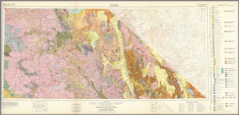
Author
California Division of Mines and Geology
Full Title
Geologic Map of California, Mariposa Sheet.
List No
6347.041
Note
Full color. Olaf P. Jenkins Edition.
Author
California Division of Mines and Geology
Full Title
Geologic Map of California, Needles Sheet.
List No
6347.045
Note
Full color. Olaf P. Jenkins Edition.
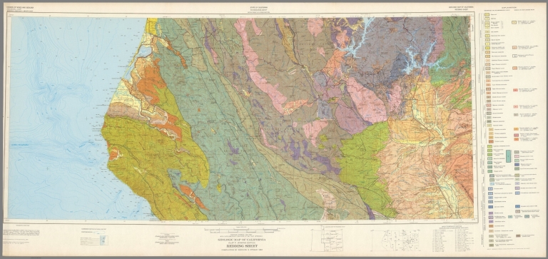
Author
California Division of Mines and Geology
Full Title
Geologic Map of California, Redding Sheet.
List No
6347.049
Note
Full color. Olaf P. Jenkins Edition.
Author
California Division of Mines and Geology
Full Title
Geologic Map of California, Sacramento Sheet.
List No
6347.053
Note
Full color. Olaf P. Jenkins Edition.
Author
California Division of Mines and Geology
Full Title
Geologic Map of California, Salton Sea Sheet.
List No
6347.057
Note
Full color. Olaf P. Jenkins Edition.
Author
California Division of Mines and Geology
Full Title
Geologic Map of California, San Bernadino Sheet.
List No
6347.061
Note
Full color. Olaf P. Jenkins Edition.
Author
California Division of Mines and Geology
Full Title
Geologic Map of California, San Diego - El Centro Sheet.
List No
6347.065
Note
Full color. Olaf P. Jenkins Edition.
Author
California Division of Mines and Geology
Full Title
Geologic Map of California, San Francisco Sheet.
List No
6347.069
Note
Full color. Olaf P. Jenkins Edition.
Author
California Division of Mines and Geology
Full Title
Geologic Map of California, San Jose Sheet.
List No
6347.073
Note
Full color. Olaf P. Jenkins Edition.
Author
California Division of Mines and Geology
Full Title
Geologic Map of California, San Luis Obisbo Sheet.
List No
6347.077
Note
Full color. Olaf P. Jenkins Edition.
Author
California Division of Mines and Geology
Full Title
Geologic Map of California, Santa Ana Sheet.
List No
6347.081
Note
Full color. Olaf P. Jenkins Edition.
Author
California Division of Mines and Geology
Full Title
Geologic Map of California, Santa Cruz Sheet.
List No
6347.085
Note
Full color. Olaf P. Jenkins Edition.
Author
California Division of Mines and Geology
Full Title
Geologic Map of California, Santa Maria Sheet.
List No
6347.089
Note
Full color. Olaf P. Jenkins Edition.
Author
California Division of Mines and Geology
Full Title
Geologic Map of California, Santa Rosa Sheet.
List No
6347.093
Note
Full color. Olaf P. Jenkins Edition.
Author
California Division of Mines and Geology
Full Title
Geologic Map of California, Trona Sheet.
List No
6347.097
Note
Full color. Olaf P. Jenkins Edition.
Author
California Division of Mines and Geology
Full Title
Geologic Map of California, Ukiah Sheet.
List No
6347.101
Note
Full color. Olaf P. Jenkins Edition.
Author
California Division of Mines and Geology
Full Title
Geologic Map of California, Walker Lake Sheet.
List No
6347.105
Note
Full color. Olaf P. Jenkins Edition.
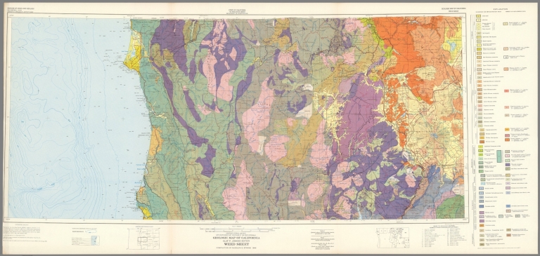
Author
California Division of Mines and Geology
Full Title
Geologic Map of California, Weed Sheet.
List No
6347.109
Note
Full color. Olaf P. Jenkins Edition.
Author
California Division of Mines and Geology
Full Title
Geologic Map of California, Westwood Sheet.
List No
6347.113
Note
Full color. Olaf P. Jenkins Edition.
Author
[Isaacs, John D., Bascom]
Full Title
SE Farralon.
List No
6349.005
Note
Black and white, vertical air photo looking east, taken October 3, 1947. Printed with north downwards.
Author
[Isaacs, John D., Bascom]
Full Title
Golden Gate SF
List No
6349.006
Note
Black and white, oblique air photo looking east, taken October 3, 1947.
Author
[Isaacs, John D., Bascom]
Full Title
Bolinas Bay.
List No
6349.007
Note
Black and white, oblique air photo looking northeast, taken October 3, 1947.
Author
[Isaacs, John D., Bascom]
Full Title
Bolinas Bay. Duxbury Reef.
List No
6349.008
Note
Black and white, oblique air photo looking north, taken October 3, 1947.
Author
[Isaacs, John D., Bascom]
Full Title
Drakes Bay and Pt. Reyes.
List No
6349.009
Note
Black and white, oblique air photo looking east, taken October 3, 1947.
Author
[Isaacs, John D., Bascom]
Full Title
Bodega Bay.
List No
6349.010
Note
Black and white, oblique air photo looking east, taken October 3, 1947.
Author
[Isaacs, John D., Bascom]
Full Title
Bodega Bay.
List No
6349.011
Note
Black and white, oblique air photo looking east, taken October 3, 1947.
Author
[Isaacs, John D., Bascom]
Full Title
Mendocino Bay.
List No
6349.012
Note
Black and white, oblique air photo looking east, taken October 3, 1947.
Author
[Isaacs, John D., Bascom]
Full Title
Noya Harbor. Fort Bragg.
List No
6349.013
Note
Black and white, oblique air photo looking east, taken October 3, 1947.
Author
[Isaacs, John D., Bascom]
Full Title
Noyo River.
List No
6349.014
Note
Black and white, oblique air photo looking southeast, taken October 3, 1947.
Author
[Isaacs, John D., Bascom]
Full Title
Cape Mendocino. Blunt's Reef.
List No
6349.015
Note
Black and white, oblique air photo looking east, taken October 3, 1947.
Author
[Isaacs, John D., Bascom]
Full Title
Eel River Outlet.
List No
6349.016
Note
Black and white, oblique air photo looking east, taken October 3, 1947.
Author
[Isaacs, John D., Bascom]
Full Title
Humboldt Bay Entrance.
List No
6349.017
Note
Black and white, oblique air photo looking east, taken October 3, 1947.
|