|
REFINE
Browse All : Images of California from 1931
1-10 of 10
Author
[Rand McNalley & Company, Texaco Oil Company]
Full Title
Texaco Road Map California Nevada Spring Edition
List No
10861.002
Note
With Road Map of the United States, maps of San Francisco, Oakland, and Los Angeles., and index.
Author
[Rand McNalley & Company, Texaco Oil Company]
Full Title
Texaco Road Map California Nevada Spring Edition
List No
10861.003
Author
Clason Map Company
Full Title
Clason's Road Map of California and Nevada. Showing paved roads, All weather roads and other throughfares. (U.S. Highways shown in red.) Published by the Clason Map Co., Chicago-Denver. Copyrighted Clason Map. All rights reserved. Map No. R-284A. (insets) Insert map of San Francisco and surrounding territory ; Los Angeles and surrounding territory.
List No
4423.048
Note
Color map. Includes road legend, and Index of cities and towns giving 1930 Census populations and Key to map.
Author
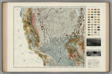
Marbut, Curtis F.
Full Title
Soil Map of the United States by Curtis F. Marbut and Associates in the Soil Survery, U.S. Department of Agriculture, F.J. Marschner, Cartographer and Associate in Compilation. 1931. Soils, Plate 5, Section 4. Lith. A. Hoen & Co., Inc. Atlas of American Agriculture.
List No
5797.085
Note
Includes legend of 12 map sections. Includes soils legend for this section and landscape photographs.
Author
Marbut, Curtis F.
Full Title
Soil Map of the United States by Curtis F. Marbut and Associates in the Soil Survery, U.S. Department of Agriculture, F.J. Marschner, Cartographer and Associate in Compilation. 1931. Soils, Plate 5, Section 5. Lith. A. Hoen & Co., Inc. Atlas of American Agriculture.
List No
5797.091
Note
Includes legend of 12 map sections. Includes soils legend for this section and landscape photographs.
Author
[Quinn, Vernon, Johst, Paul Spener]
Full Title
California.
List No
7967.053
Author
Cormack, Robert
Full Title
Mother Lode map : incorporating mother lodes of California and Nevada, scenes of the "Romantic days of Gold". Cartographer: Robert Cormack. Published by Mother Lode Enterprises.
List No
8019.000
Note
Pictorial map. Extends from the Central Valley to the Comstock Lode, Nevada. Oriented with north toward upper right. Shows rivers, roads, railroads, lakes, etc. Includes text describing famous landmarks, points of interest and location of Literary High Lights of the Mother Lode County. Date is estimated. Note : "The Days of Old, The Days of Gold, The Days of '49 ..."
Author
Mora, Jo (1876-1947)
Full Title
(Covers to) Yosemite. (Drawn by) Jo Mora. Copyright 1931. The Jo Mora Maps, Carmel California.
List No
8076.001
Note
Uncolored pictorial map of Yosemite Valley, folded in mailing envelope 21x28.5, with title: "A Jo Mora map of Yosemite. Jo Mora, Carmel Cal." Map shows many humorous scenes and the activities common at the time in the Valley. Many landmarks are shown in an amusing way with annotation. For example, a cloud resting on an easy chair, a bishop is straddling the Cathedral Spires, Sentinel Hotel, Zoo, and old Big Oak Flat Road. Includes vignette illustrations in the border of Scenes and activities. Artist Joseph "Jo" Jacinto Mora was born in Uruguay in 1876 and became an illustrator after moving to the Untied States in the early 1900s. For more information on Jo Mora's life and works, see http://www.jomoratrust.com
Author
Mora, Jo (1876-1947)
Full Title
Yosemite. (Drawn by) Jo Mora. Copyright 1931. The Jo Mora Maps, Carmel California.
List No
8076.002
Note
Uncolored pictorial map of Yosemite Valley, folded in mailing envelope 21x28.5, with title: "A Jo Mora map of Yosemite. Jo Mora, Carmel Cal." Map shows many humorous scenes and the activities common at the time in the Valley. Many landmarks are shown in an amusing way with annotation. For example, a cloud resting on an easy chair, a bishop is straddling the Cathedral Spires, Sentinel Hotel, Zoo, and old Big Oak Flat Road. Includes vignette illustrations in the border of Scenes and activities. Artist Joseph "Jo" Jacinto Mora was born in Uruguay in 1876 and became an illustrator after moving to the Untied States in the early 1900s. For more information on Jo Mora's life and works, see http://www.jomoratrust.com
Author
Cormack, Robert
Full Title
Mother Lode map : incorporating Mother Lodes of California and Nevad, scenes of the "Romantic Days of Gold". Copyright 1931 by the California Art & Engraving Co. Engravers and publishers: Berkeley Calif. Cartographer Robert Cormack.
List No
8226.000
Note
Pictorial map. Extends from the Central Valley to the Comstock Lode, Nevada. Compass rose oriented with north toward upper right. Shows rivers, roads, railroads, lakes, wildlife, points of interest, etc. Includes text describing famous landmarks, points of interest and location of Literary High Lights of the Mother Lode County. Note : "The Days of Old, The Days of Gold, The Days of '49 ..."
1-10 of 10
|