|
Author
U.S. Coast Survey
Full Title
(Covers to) Treasury Department. United States Coast and Geodetic Survey. Special Publication No. 1. California, Bay of San Francisco. Magnetic Ranges for Determining the Deviation of the Compass, with Short Explanations of How to Find the Deviation and Error of the Compass. These Ranges were Determined by the U.S. Coast Guard Steamer "McArthur," Lieut. J.M. Helm, U.S.N. Commanding. Arranged and Compiled by Lieut. J.C. Gillmore, United States Navy, Assistant, U.S. Coast and Geodetic Survey. Washington: Government Printing Office. 1898.
List No
2698.001
Note
Paper covered booklet. Full title, as above, printed on the front.
Author
U.S. Coast Survey
Full Title
(Title Page to) Treasury Department. United States Coast and Geodetic Survey. Special Publication No. 1. California, Bay of San Francisco. Magnetic Ranges for Determining the Deviation of the Compass, with Short Explanations of How to Find the Deviation and Error of the Compass. These Ranges were Determined by the U.S. Coast Guard Steamer "McArthur," Lieut. J.M. Helm, U.S.N. Commanding. Arranged and Compiled by Lieut. J.C. Gillmore, United States Navy, Assistant, U.S. Coast and Geodetic Survey. Washington: Government Printing Office. 1898.
List No
2698.002
Author
U.S. Coast Survey
Full Title
(Text Page) Preface.
List No
2698.003
Author
U.S. Coast Survey
Full Title
(Text Page) Magnetic Ranges in the Bay of San Francisco, California, for Determining the Deviation of the Compass.
List No
2698.004
Note
Explanation of how to find the deviation of the compass.
Author
U.S. Coast Survey
Full Title
(Text Page) Magnetic Ranges, San Francisco Bay (continued).
List No
2698.005
Note
Explanation of how to find the compass error.
Author
U.S. Coast Survey
Full Title
(Views of San Francisco Nos. 1-2).
List No
2698.006
Note
Two black and white photographic views of San Francisco, Mission Rock and San Francisco's Gas and Electric Co.'s chimney, precisely keyed to map image 2698.012.
Author
U.S. Coast Survey
Full Title
(Views of San Francisco Nos. 3-4).
List No
2698.007
Note
Two black and white photographic views of San Francisco, Shot Tower and Pier No. 9, precisely keyed to map image 2698.012.
Author
U.S. Coast Survey
Full Title
(Views of San Francisco Nos. 5-6).
List No
2698.008
Note
Two black and white photographic views of San Francisco, U.S. Barge Office and Arch Rock, precisely keyed to map image 2698.012.
Author
U.S. Coast Survey
Full Title
(Views of San Francisco Nos. 7-8).
List No
2698.009
Note
Two black and white photographic views of San Francisco, Presidio flagstaff and Fort Point light house, precisely keyed to map image 2698.012.
Author
U.S. Coast Survey
Full Title
(Views of San Francisco Nos. 9-10).
List No
2698.010
Note
Two black and white photographic views of San Francisco, Cliff House Tower and Drake Cross, precisely keyed to map image 2698.012.
Author
U.S. Coast Survey
Full Title
(Text Page) Form for Ranges in San Francisco Bay for Determing the Deviation of the Compass.
List No
2698.011
Author
U.S. Coast Survey
Full Title
Treasury Department, U.S. Coast and Geodetic Survey, Magnetic Ranges for Compass Deviation, San Francisco Bay, California. Published December, 1897, Henry S. Pritchett, Superintendent. Verified: O.H. Tittmann, Assistant ... E.D. Taussig, Lieut. Comdr., U.S.N., Hydrographic Inspector. A.R. Graham Photo. Lith. Washington D.C.
List No
2698.012
Note
Chart of vicinity of San Francisco showing lines of sight for photographs shown previously.
Author
Reynolds & Proctor
Full Title
(Covers to) Illustrated atlas of Sonoma County, California. Compiled and published from personal examinations, official records and actual surveys. Published by Reynolds & Proctor, Santa Rosa, Cal. Entered ... 1897, by Reynolds & Proctor, Santa Rosa, Cal. (1898)
List No
3341A
Note
Half leather black cloth covered boards stamped with "Illustrated atlas of Sonoma County, California" in gilt on the front and blind stamped on the back.
Author
Reynolds & Proctor
Full Title
(Title Page to) Illustrated atlas of Sonoma County, California. Compiled and published from personal examinations, official records and actual surveys. Published by Reynolds & Proctor, Santa Rosa, Cal. Entered ... 1897, by Reynolds & Proctor, Santa Rosa, Cal. (1898)
List No
3341B
Note
Lithographed title page, b&w with view of the "Court House."
Full Title
W.D. Reynolds. T.A. Proctor. (Published by Reynolds & Proctor, Santa Rosa, Cal., 1898)
List No
3341.001
Note
Two sepia-tone lithographic portraits.
Author
Reynolds & Proctor
Full Title
(Contents to) Illustrated atlas of Sonoma County, California. Compiled and published from personal examinations, official records and actual surveys. Published by Reynolds & Proctor, Santa Rosa, Cal. Entered ... 1897, by Reynolds & Proctor, Santa Rosa, Cal. (1898)
List No
3341C
Full Title
Map of California, compiled from official and reliable sources. 1898. (Published by Reynolds & Proctor, Santa Rosa, Cal., 1898)
List No
3341.002
Note
Col. lithographed map. Relief shown by hachures. Shows counties in full color, settlements, railroads, drainage, etc.
Full Title
Map of Sonoma County, California. 1898. (Published by Reynolds & Proctor, Santa Rosa, Cal., 1898)
List No
3341.003
Note
Col. lithographed map. Relief shown by hachures. Shows political townships (in full color) , U.S. Public Land townships and sections, land grants, settlements, railroads, drainage, etc. Includes index to towns.
Full Title
T. 11 N., R. 15 W. (with) Geyserville. (Published by Reynolds & Proctor, Santa Rosa, Cal., 1898)
List No
3341.004
Note
Col. lithographed map. Relief shown by hachures. Shows Public Land townships and sections, land grants, landowners with acreages, settlements, drainage, etc. Inset map at (1:14,400)
Full Title
T. 11 N., R. 14 W. (Published by Reynolds & Proctor, Santa Rosa, Cal., 1898)
List No
3341.005
Note
Col. lithographed map. Relief shown by hachures. Shows Public Land townships and sections, landowners with acreages, drainage, etc.
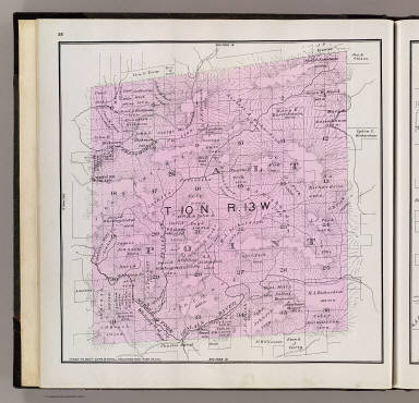
Full Title
T. 11 N., R. 13 W. (Published by Reynolds & Proctor, Santa Rosa, Cal., 1898)
List No
3341.006
Note
Col. lithographed map. Relief shown by hachures. Shows Public Land townships and sections, landowners with acreages, drainage, etc. Covers part of Mendocino Township.
Full Title
T. 11 N., R. 12 W. (Published by Reynolds & Proctor, Santa Rosa, Cal., 1898)
List No
3341.007
Note
Col. lithographed map. Relief shown by hachures. Shows Public Land townships and sections, landowners with acreages, drainage, etc. Covers part of Mendocino Township.
Full Title
T. 11 N., R. 11 W. (Published by Reynolds & Proctor, Santa Rosa, Cal., 1898)
List No
3341.008
Note
Col. lithographed map. Relief shown by hachures. Shows Public Land townships and sections, part of Rancho Musalacon, landowners with acreages, part of Cloverdale Township, drainage, etc.
Full Title
T. 11 N., R. 10 W., T. 12 N., R. 10 W. (Published by Reynolds & Proctor, Santa Rosa, Cal., 1898)
List No
3341.009
Note
Col. lithographed map. Relief shown by hachures. Shows Public Land townships and sections, Rancho Musalacon, Rancho Caslamayomi, Cloverdale, Asti, Cloverdale Township, landowners with acreages, railroad, drainage, etc. Covers only a portion of T. 12 N., R. 10 W.
Full Title
T. 11 N., R. 9 W., T. 12 N., R. 9 W. (Published by Reynolds & Proctor, Santa Rosa, Cal., 1898)
List No
3341.010
Note
Col. lithographed map. Relief shown by hachures. Shows Public Land townships and sections, Rancho Caslamayomi, part of Cloverdale Township, Geysers, Geyser Peak, landowners with acreages, drainage, etc. Covers only part of T. 12 N., R. 9 W.
Full Title
T. 11 N., R. 8 W. (Published by Reynolds & Proctor, Santa Rosa, Cal., 1898)
List No
3341.011
Note
Col. lithographed map. Relief shown by hachures. Shows Public Land townships and sections, landowners with acreages, Little Geysers, Socrates Mine, drainage, etc.
Full Title
T 10 N., R. 15 W. (with) Forestville. (with) Guerneville. (with) Valley Ford. (Published by Reynolds & Proctor, Santa Rosa, Cal., 1898)
List No
3341.012
Note
Col. lithographed map with 3 insets. Relief shown by hachures. Shows German Rancho, landowners with acreages, drainage, etc.
Full Title
T. 10 N., R. 14 W. (Published by Reynolds & Proctor, Santa Rosa, Cal., 1898)
List No
3341.013
Note
Col. lithographed map. Relief shown by hachures. Shows Public Land townships and sections, German Rancho, Salt Point Township, Black Point, railroad, landowners with acreages, drainage, etc.
Full Title
T. 10 N., R. 13 W. (Published by Reynolds & Proctor, Santa Rosa, Cal., 1898)
List No
3341.014
Note
Col. lithographed map. Relief shown by hachures. Shows Public Land townships and sections, part of Salt Point Township, landowners with acreages, drainage, etc.
Full Title
T. 10 N., R. 12 W. (Published by Reynolds & Proctor, Santa Rosa, Cal., 1898)
List No
3341.015
Note
Col. lithographed map. Relief shown by hachures and spot heights. Shows Public Land townships and sections, landowners with acreages, part of Mendocino Township, drainage, etc.
Full Title
T. 10 N., R. 11 W. (Published by Reynolds & Proctor, Santa Rosa, Cal., 1898)
List No
3341.016
Note
Col. lithographed map. Relief shown by hachures. Shows Public Land townships and sections, landowners with acreages, Skaggs Springs, present-day Lake Sonoma, part of Mendocino Township, drainage, etc.
Full Title
T. 10 N., R. 10 W. (Published by Reynolds & Proctor, Santa Rosa, Cal., 1898)
List No
3341.017
Note
Col. lithographed map. Relief shown by hachures. Shows Public Land townships and sections, Tzabaco Rancho, Mendocino Township, landowners with acreages, railroad, drainage, etc.
Full Title
T. 10 N., R. 9 W. (Published by Reynolds & Proctor, Santa Rosa, Cal., 1898)
List No
3341.018
Note
Col. lithographed map. Relief shown by hachures. Shows Public Land townships and sections, Caslamayomi, Sotoyome and Tzabaco ranchos, landowners with acreages, Washington township, Geyserville, railroad, drainage, etc.
Full Title
T. 10 N., R. 8 W. (Published by Reynolds & Proctor, Santa Rosa, Cal., 1898)
List No
3341.019
Note
Col. lithographed map. Relief shown by hachures. Shows Public Land townships and sections, landowners with acreages, drainage, Knights Valley Township, Pine Flat and Double Pine district schools, etc.
Full Title
T. 10 N., R. 7 W. (with) Occidental. (Published by Reynolds & Proctor, Santa Rosa, Cal., 1898)
List No
3341.020
Note
Col. lithographed map. Relief shown by hachures and spot heights. Shows Public Land townships and sections, landowners with acreages, drainage, Mount Saint Helena, etc. Occidental map at 1:4,800 scale and shows lot numbers, railroad, etc.
Full Title
Cloverdale. (Published by Reynolds & Proctor, Santa Rosa, Cal., 1898)
List No
3341.021
Note
Col. lithographed map. Shows block and lot numbers, tracts, large parcel landowners, railroad, drainage, etc.
Full Title
T. 9 N., R. 14 W. (Published by Reynolds & Proctor, Santa Rosa, Cal., 1898)
List No
3341.022
Note
Col. lithographed map. Relief shown by hachures. Shows Public Land township and sections, German Rancho, Stewart's Point, Fisherman Bay, Horse Shoe Bay, landowners with acreages, drainage, etc.
Full Title
T. 9 N., R. 13 W. (Published by Reynolds & Proctor, Santa Rosa, Cal., 1898)
List No
3341.023
Note
Col. lithographed map. Relief shown by hachures. Shows Public Land townships and sections, German Rancho, Salt Point township, landowners with acreages, Gualala, Fisk's Mill and Dirigo district schools, drainage, etc.
Full Title
T. 9 N., R. 12 W. (Published by Reynolds & Proctor, Santa Rosa, Cal., 1898)
List No
3341.024
Note
Col. lithographed map. Relief shown by hachures. Shows Public Land townships and sections, landowners with acreages, settlements, drainage, Table Mountain district school, etc.
Full Title
T. 9 N., R. 11 W. (Published by Reynolds & Proctor, Santa Rosa, Cal., 1898)
List No
3341.025
Note
Col. lithographed map. Relief shown by hachures. Shows Public Land townships and sections, landowners with acreages, Mendocino Township, Austin Creek district school, drainage, etc.
Full Title
T. 9 N., R. 10 W. (Published by Reynolds & Proctor, Santa Rosa, Cal., 1898)
List No
3341.026
Note
Col. lithographed map. Relief shown by hachures. Shows Public Land townships and sections, Sotoyome Rancho, landowners with acreages, Davis and Grape district schools, Mendocino Township, drainage, etc.
Full Title
T. 9 N., R. 9 W. (Published by Reynolds & Proctor, Santa Rosa, Cal., 1898)
List No
3341.027
Note
Col. lithographed map. Relief shown by hachures. Shows Public Land townships and sections, landowners with acreages, Healdsburg, Lytton, Sotoyome Rancho, railroad, drainage, etc.
Full Title
T. 9 N., R. 8 W. (Published by Reynolds & Proctor, Santa Rosa, Cal., 1898)
List No
3341.028
Note
Col. lithographed map. Relief shown by hachures. Shows Public Land townships and sections, Sotoyome and Mallacomes ranchos, Knights Valley and Russian River townships, Maacama district school, landowners with acreages, drainage, etc.
Full Title
T. 9 N., R. 7 W. (with) Cotati. (with) Fulton. (Published by Reynolds & Proctor, Santa Rosa, Cal., 1898)
List No
3341.029
Note
Col. lithographed map. Relief shown by hachures. Shows Public Land townships and sections, Mallacomes Rancho, Knights Valley Township, Kellogg, landowners with acreages, drainage, etc. Cotati at 1:7,200 scale; Fulton at 1:3,600.
Full Title
T. 8 N., R. 13 W. (with) Duncan's. (Published by Reynolds & Proctor, Santa Rosa, Cal., 1898)
List No
3341.030
Note
Col. lithographed map. Relief shown by hachures. Shows Public Land townships and sections, German and Muniz ranchos, Fort Ross, Salt Point, Gerstler Cove, Timber Cove, landowners with acreages, drainage, etc. Duncans Mills at 1:4,800 scale.
Full Title
T. 8 N., R. 12 W. (Published by Reynolds & Proctor, Santa Rosa, Cal., 1898)
List No
3341.031
Note
Col. lithographed map. Relief shown by hachures. Shows Public Land townships and sections, Muniz Rancho, Fort Ross, Creighton Ridge district school, Sea View P.O., landowners with acreages, etc.
Full Title
T. 8 N., R. 11 W. (Published by Reynolds & Proctor, Santa Rosa, Cal., 1898)
List No
3341.032
Note
Col. lithographed map. Relief shown by hachures and spot heights Shows Public Land townships and sections, Redwood and Ocean townships, Mount Ross, Cazadero, Kidd Creek, Montgomery and Madrona district schools, landowners with acreages, railroad, drainage, etc.
Full Title
T. 8 N., R. 10 W. (Published by Reynolds & Proctor, Santa Rosa, Cal., 1898)
List No
3341.033
Note
Col. lithographed map. Relief shown by hachures. Shows Public Land townships and sections, Sotoyome Rancho, Redwood Township, Guerneville, Korbell Station, landowners with acreages, railroad, drainage, etc.
Full Title
T. 8 N., R. 9 W. (Published by Reynolds & Proctor, Santa Rosa, Cal., 1898)
List No
3341.034
Note
Col. lithographed map. Relief shown by hachures. Shows Public Land townships and sections, Sotoyome and El Molino ranchos, Mendocino and Russian River townships, West Windsor, East Windsor, landowners with acreages, railroad, drainage, etc.
Full Title
T. 8 N., R. 8 W. (Published by Reynolds & Proctor, Santa Rosa, Cal., 1898)
List No
3341.035
Note
Col. lithographed map. Relief shown by hachures. Shows Public Land townships and sections, landowners with acreages, Fulton, Mark West, Mark West Springs, Russian River and Santa Rosa townships, railroad, drainage, etc.
|