|
REFINE
Browse All : Images of California from 1845
1-20 of 20
Author
Fremont, J.C.
Full Title
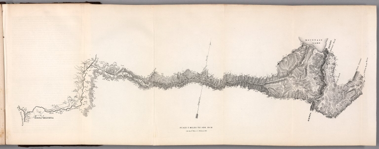
Map Of An Exploring Expedition To The Rocky Mountains in the Year 1842, Oregon & North California In The Years 1843-44. By Brevet Capt. J. C. Fremont Of The Corps Of Topographical Engineers Under the orders of Col. J.J. Abert, Chief Of The Topographical Bureau. Lith. by E. Weber & Co. Baltimore, Md.
List No
10280.000
Note
Senate Issue; map in case. See our 1833.001 for the House issue map which appears to be identical. Text has the astronomical observations that are not in the House issue. The large map of the west is one of the most interesting and beautiful government maps of the 1840's. It filled in many of the gaps in cartographic knowledge of the west. Charles Preuss was the cartographer. Map is without color except for a light blue for water areas.
Author
Fremont John Charles, 1813-1890
Full Title
Pass in the Sierra Nevada of California. Lith. by E. Weber & Co. Baltimore. (to accompany) Report of The Exploring Expedition to The Rocky Mountains in the Year 1842, and to Oregon & North California In The Years 1843-44. By Brevet Capt. J. C. Fremont ... Washington : Gales and Seaton, Printers. 1845.
List No
13406.021
Note
Lithograph map. Published by E. Weber & Co.
Author
Fremont John Charles, 1813-1890
Full Title
(Map of the crossing of the Sierra Nevada by the South Fork of the American River). Lith. by E. Weber & Co. Baltimore. (to accompany) Report of The Exploring Expedition to The Rocky Mountains in the Year 1842, and to Oregon & North California In The Years 1843-44. By Brevet Capt. J. C. Fremont ... Washington : Gales and Seaton, Printers. 1845.
List No
13406.022
Note
Untitled folding map of the crossing of the Sierra Nevada. Published by E. Weber & Co.
Author
Fremont John Charles, 1813-1890
Full Title
Fossil fresh water infusoria from Oregon. J. W. Bailey del. Lith. by E. Weber & Co. Baltimore. (to accompany) Report of The Exploring Expedition to The Rocky Mountains in the Year 1842, and to Oregon & North California In The Years 1843-44. By Brevet Capt. J. C. Fremont ... Washington : Gales and Seaton, Printers. 1845.
List No
13406.023
Note
24 lithograph views of fossil shells. Published by E. Weber & Co. In upper right margin: PL. V.
Author
Fremont John Charles, 1813-1890
Full Title
Fossil Ferns : Collection of the Geographical Survey of Oregon and North California. Lith. by E. Weber & Co. Baltimore. (to accompany) Report of The Exploring Expedition to The Rocky Mountains in the Year 1842, and to Oregon & North California In The Years 1843-44. By Brevet Capt. J. C. Fremont ... Washington : Gales and Seaton, Printers. 1845.
List No
13406.024
Note
8 lithograph views of fossil Ferns in 11 parts. Published by E. Weber & Co. In upper right margin: PL. I.
Author
Fremont John Charles, 1813-1890
Full Title
Fossil Ferns : Collection of the Geographical Survey of Oregon and North California. Lith. by E. Weber & Co. Baltimore. (to accompany) Report of The Exploring Expedition to The Rocky Mountains in the Year 1842, and to Oregon & North California In The Years 1843-44. By Brevet Capt. J. C. Fremont ... Washington : Gales and Seaton, Printers. 1845.
List No
13406.025
Note
5 lithograph views of fossil Ferns in 15 parts. Published by E. Weber & Co. In upper right margin: PL. II.
Author
Fremont John Charles, 1813-1890
Full Title
Fossil Ferns : Collection of the Geographical Survey of Oregon and North California. Lith. by E. Weber & Co. Baltimore. (to accompany) Report of The Exploring Expedition to The Rocky Mountains in the Year 1842, and to Oregon & North California In The Years 1843-44. By Brevet Capt. J. C. Fremont ... Washington : Gales and Seaton, Printers. 1845.
List No
13406.026
Note
14 lithograph views of fossil Ferns in 20 parts. Published by E. Weber & Co. In upper right margin: PL. III.
Author
Fremont John Charles, 1813-1890
Full Title
Fossil Shells : Collection of the Geographical Survey of Oregon and North California. Lith. by E. Weber & Co. Baltimore. (to accompany) Report of The Exploring Expedition to The Rocky Mountains in the Year 1842, and to Oregon & North California In The Years 1843-44. By Brevet Capt. J. C. Fremont ... Washington : Gales and Seaton, Printers. 1845.
List No
13406.027
Note
3 lithograph view. Published by E. Weber & Co. In upper right margin: Botany Plate IV.
Author
Fremont John Charles, 1813-1890
Full Title
Ardomecon Californicum. Lith. by E. Weber & Co. Baltimore. (to accompany) Report of The Exploring Expedition to The Rocky Mountains in the Year 1842, and to Oregon & North California In The Years 1843-44. By Brevet Capt. J. C. Fremont ... Washington : Gales and Seaton, Printers. 1845.
List No
13406.028
Note
Lithograph view. Published by E. Weber & Co. In upper right margin: Botany Plate II.
Author
Fremont John Charles, 1813-1890
Full Title
Prosopis odorata. Lith. by E. Weber & Co. Baltimore. (to accompany) Report of The Exploring Expedition to The Rocky Mountains in the Year 1842, and to Oregon & North California In The Years 1843-44. By Brevet Capt. J. C. Fremont ... Washington : Gales and Seaton, Printers. 1845.
List No
13406.029
Note
Lithograph view. Published by E. Weber & Co. In upper right margin: Botany Plate I.
Author
Fremont John Charles, 1813-1890
Full Title
Fremontia Vermicularis. Lith. by E. Weber & Co. Baltimore. (to accompany) Report of The Exploring Expedition to The Rocky Mountains in the Year 1842, and to Oregon & North California In The Years 1843-44. By Brevet Capt. J. C. Fremont ... Washington : Gales and Seaton, Printers. 1845.
List No
13406.030
Note
Lithograph view. Published by E. Weber & Co. In upper right margin: Botany Plate III.
Author
Anonymous
Full Title
Kaliforniya. (Kalifornia) Verkhnyaya Kaliforniya.
List No
11957.000
Note
Engraved map in Russian of Northern California and Mexico, Baja California. Shows international and administrative boundaries, cities, towns, rivers and mountains. Relief shown by hachures. Date is estimated based on showing of Pyramid Lake from the Fremont 1845 map. The map appears to have been published in Russia as a separate map, not in any reports we can locate. It shows the Russian settlement at Fort Ross on the California coast. It might have been a map advocating for increased Russian exploration and settlement in California. There is no mention of the gold rush on the map, thus it is likely to have been published before 1849. We have not been able to located any other copies at libraries.
Author
Fremont, J.C.
Full Title
(Title Page to) Report of The Exploring Expedition to The Rocky Mountains in the Year 1842, and to Oregon and North California in the Years 1843-'44.
List No
1833A
Author
Fremont, J.C.
Full Title
Map Of An Exploring Expedition To The Rocky Mountains in the Year 1842, Oregon & North California In The Years 1843-44. By Brevet Capt. J. C. Fremont Of The Corps Of Topographical Engineers Under the orders of Col. J.J. Abert, Chief Of The Topographical Bureau. Lith. by E. Weber & Co. Baltimore, Md.
List No
1833.001
Note
House Issue; map in case. Lacks the astronomical observations that appear in the first issue by the Senate. The large map of the west is one of the most interesting and beautiful government maps of the 1840's. It filled in many of the gaps in cartographic knowledge of the west. Charles Preuss was the cartographer. Fremont and Preuss mapped only what they saw along their routes, leaving large areas blank. Map is without color. Book is bound with full leather with "Executive Documents 2d Sess. 28th Cong." on the spine in gold.
Author
Farnham, Thomas Jefferson, 1804-1848
Full Title
Map of the Californias by T.J. Farnham. Entered ... 1845 by Thomas J. Farnham ... New York. (New York: Published by Harper & Brothers, 1845)
List No
2301.034
Note
Col. wax engraved map. Relief shown by hachures. Bar scale incorrect. Covers also parts of New Mexico, Chihuahua and Sonora. Prime meridians: Washington and Greenwich.
Author
[Morse, Sidney E. (Sidney Edwards), 1794-1871, Breese, S.]
Full Title
Map of the Californias; by T.J. Farnham. (to accompany) Supplement To The New-York Observer. The Cerographic Atlas Of The United States. No.3. 1845. Entered ... 1845, by Sidney E. Morse and Samuel Breese ... New-York.
List No
4180.034
Note
Uncolored map. Shows settlements, roads, railroads, rivers, missions, Farnham and Dr, Lyman's routes, etc. Relief shown by hachures. Prime meridians are Greenwich and Washington.
Author
Agate, A. T.
Full Title
Shaste Peak. Drawn by A.T. Agate. Engraved by G.B. Ellis. (Philadelphia: Lea & Blanchard. 1845)
List No
4442.070
Note
Engraved view, b&w, of Mount Shasta with two Indians and trees (some fallen) in foreground.
Author
Agate, A. T.
Full Title
Encampment on the Sacramento. Drawn by A.T. Agate. J.W. Steel sc. (Philadelphia: Lea & Blanchard. 1845)
List No
4442.071
Note
Engraved view, b&w. Shows men and pack animals resting in an expansive landscape along the Sacramento River. Mountains (Sutter Buttes?) in background.
Author
Farnham, Thomas Jefferson, 1804-1848
Full Title
Map of the Californias by T.J. Farnham. Entered ... 1845 by Thomas J. Farnham ... New York. (New York: Published by Harper & Brothers, 1845). (to accompany) Morse's Cerographic Maps. No. III.
List No
4861.026
Note
Color wax engraved map. Shows cities, towns, rail roads, road, rivers, etc. Bar scale incorrect. Covers also parts of New Mexico, Chihuahua and Sonora. Releif shown by hachures. Prime meridians are Greenwich and Washington.
Author
[Morse, Sidney E. (Sidney Edwards), 1794-1871, Breese, Samuel]
Full Title
(Title Page/Contents to) Morse's Cerographic Maps. No.4. Plan Of Publication ... Each number will contain four coloured Maps ... If practicable, from two to three numbers will be issued every month ... The first ten numbers will form a comprehensive and elegant North American Atlas for the Library, the Counting House, and the School room ... Contents of No. IV. Texas. Kentucky. Tennessee. Indiana. South Carolina. New-York. Harper And Brothers, 82 Cliff Street. 1845 ... Price 25 Cts.
List No
4861.029
Note
Fourth part of the nine original parts of four colored maps each, in illustrated printed wrappers, of Morse's North American Atlas. Each part is dated 1845, so we assume they were all issued in that year, one or two a month. The "Plan of Publication" on the front wrapper of each part calls for ten numbers, but only nine were issued. The wraps are decorated with a palm tree, fir tree, bear, giraffe, and four seals for each of the continents. The cheap price of the product is stressed: "Each number will contain four coloured Maps, the price of which will be twenty five cents, being about one fourth the cost of copper plate Maps of similar size." After publication of the parts, Morse also issued the complete atlas bound (see our #2301). This nine part issue is to be distinguished from the earlier three part issue of 32 uncolored maps as supplements to the New York Observer (see our #4180). This copy with the signature and ms index of Robert Rantoul of Beverly, Massachusetts, noted lawyer and reformer. Printed full color. This copy is folded into green cloth covered boards which slips into a quarter leather green cloth covered folio box titled "Morse's North American Atlas - 9 Original Parts - New York, 1845" in gold along the spine.
1-20 of 20
|