|
Author
[White, Ruth Taylor, Western Air Express]
Full Title
Los Angeles-Salt Lake City : 600 miles - 6 hours. Over old Mormon Trail. Cartograph by Ruth Taylor White. (to accompany) Western Air Express Travel by Air : Travel by Western Air Express : Speend - comfort - dependability. Cartograph by Ruth Taylor White. Printed in U.S.A. in October, 1929.
List No
11777.005
Note
Double page pictorial map. Showing Western Air express routes, flying times and distance, major cites landmarks, forest, winter and Summer sports, recreational activities, places of interest, industry, farms, rivers and mountains. Relief shown pictorially. Includes a Tri-motored Fokker type aircraft, compass rose decorated with arrowhead logo and text "The Los Angeles-Salt Lake City has bee operating since April, 1926 ..."
Author
Geological Survey (U.S.)
Full Title
Central Pacific states.
List No
14359.026
Note
Map representing the Central Pacific States within the United States, as of 1970. Shows political boundaries, cities, railways, roads, ferry lines, Indian reservations, national forests and parks, mountains, mesas, valleys, deserts, bodies of water, drainage, coastlines and islands. Relief shown with labeling of mountain names and peak heights. Features population density for each city. Includes latitudinal and longitudinal lines, bar scale and scale statement. Presented with Albers Equal Area Projection. Colored lithograph. Map is 42 x 68 cm, on double sheet 49 x 71 cm. Index map and legend appear on page 5. Appears in General reference maps section.
Author
[Berghaus, Heinrich, 1797-1884, Sohr, Karl, Flemming, Carl]
Full Title
Californien, Oregon, Utah und Neu-Mejico. Entw. u. gez. v. F. Handtke. Druck u. Verlag v. C. Flemming in Glogau. (to accompany) Vollstandiger Universal-Handatlas der neueren Erdbeschreibung ,,, Heinrich Berghaus ... 1859.
List No
13250.128
Note
Hand colored in outline map. Includes color coded list of administrative boundaries. Relief shown by hachures. Prime meridians are Paris and Ferro.
Author
Bancroft, A.L.
Full Title
Bancroft's Map Of California, Nevada, Utah And Arizona. Published By A.L. Bancroft & Compy. Booksellers & Stationers, San Francisco, Cal. 1873. Entered ... by A.L. Bancroft & Company ... Washington, D.C.
List No
0046.000
Note
1st edition was 1864. From Bancroft's Map the of Pacific States which appeared in 1863. Wheat says Bancroft changed the large Pacific States map in 1870, but we believe that the smaller maps such as this continue to be from the original 1863 or 1867 plates, updated to show railroad expansion and topographical changes. With black top and bottom rollers. Full color by county.
Author
[Bancroft, A.L., Knight, W.H.]
Full Title
(Covers to) Bancroft's Map Of California, Nevada, Utah And Arizona. Published By A.L. Bancroft, & Compy. Booksellers & Stationers San Francisco Cal. 1876. Entered ... by A.L. Bancroft & Company ... Washington, D.C.
List No
0047.001
Note
Additional railroads when compared to the 1873 edition. Full color by county. Folded into dark brown cloth covers 16x11 with title "Bancroft's Map Of California, Nevada, Utah & Arizona." in gold. Relief shown by hachures.
Author
[Bancroft, A.L., Knight, W.H.]
Full Title
Bancroft's Map Of California, Nevada, Utah And Arizona. Published By A.L. Bancroft, & Compy. Booksellers & Stationers San Francisco Cal. 1876. Entered ... by A.L. Bancroft & Company ... Washington, D.C.
List No
0047.002
Note
Additional railroads when compared to the 1873 edition. Full color by county. Folded into dark brown cloth covers 16x11 with title "Bancroft's Map Of California, Nevada, Utah & Arizona." in gold. Relief shown by hachures.
Author
Colton, G.W.
Full Title
Colton's Map of California, Nevada, Utah, Colorado, Arizona & New Mexico. Published By J. H. Colton. No. 172 William St. New York.
List No
0151.062
Note
Shows routes, dates of exploration and the explorers. Prime meridians are Greenwich and Washington D.C. Relief shown by hachures
Author
Colton, G.W.
Full Title
Colton's Map of California, Nevada, Utah, Colorado, Arizona and New Mexico. Published By G. W & C. B. Colton & Co. No. 172 William St. New York.
List No
0152.064
Note
Prime meridians are Washington D.C. and Greenwich.
Author
Johnson, A.J.
Full Title
Johnson's California, With Territories of Utah, Nevada, Colorado, New Mexico And Arizona,Published By Johnson and Ward. Entered ... 1864, by A.J. Johnson ... New York.
List No
0352.044
Note
Full color by counties, with heavy outlines around the states. detail mining districts, political divisions, emigrant trails, the Santa Fe Trail, the Pony Express Route, several proposed Union Pacific railroads, and Indian tribes and territories. This important map went through several different states during its publication period from 1860 to 1870. This critical period in westward expansion saw incredible development and change throughout the region. This, the 1864 Johnson and Ward version represents a complete re-engraving of the 1862-1863 map. Johnson added considerable detail in the mountainous regions of California, Nevada and Colorado. Arizona and New Mexico appear as independent territories but shows the old "New Mexico" county structure. The southern boundary of Nevada with Arizona is set at 37 degrees of Latitude such that Las Vegas, shown within Arizona. Relief shown by hachures. Prime meridians are Greenwich and Washington D.C.
Author
Johnson, A.J.
Full Title
Johnson's California also Utah, Nevada, Colorado, New Mexico, and Arizona. Entered ... 1864.
List No
0358.049
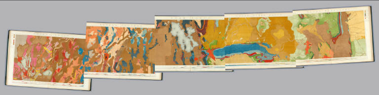
Author
King, Clarence
Full Title
(Covers to) Engineer Department U.S.A. Geological and Topographical Atlas Accompanying the Report of the Geological Exploration of the Fortieth Parallel Made by the Authority of the Honorable Secretary of War under the direction of Brig. and Brvt. Major General A.A. Humphreys, Chief of Engineers U.S.A. by Clarence King, U.S. Geologist in Charge, 1876. Julius Bien Lith.
List No
0408A
Author
King, Clarence
Full Title
(Title Page to) Engineer Department U.S.A. Geological and Topographical Atlas Accompanying the Report of the Geological Exploration of the Fortieth Parallel Made by the Authority of the Honorable Secretary of War under the direction of Brig. and Brvt. Major General A.A. Humphreys, Chief of Engineers U.S.A. by Clarence King, U.S. Geologist in Charge, 1876. Julius Bien Lith.
List No
0408B
Note
Magnificent, huge atlas showing the area of the 40th Parallel Survey in topographical and geological maps. Wheat notes: "These are pioneer survey maps, and as such are most interesting. Mapping the West in so broad a cross-section had never before been attempted, a portent of things to come." King, at the age of 25, was made Geologist-in-charge of the Survey in 1867. He was formally ordered "to examine and describe the geological structure, geographical condition and natural resources of a belt of country extending from the 120th meridian eastward to the 105th meridian, along the 40th parallel of latitude with sufficient expansion north and south to include the lines of 'Central' and 'Union Pacific' railroads..." (Wheat). The topographical sheets depict features by brush shading rather than hachuring. In original binding -rare. Bound in green half leather with a label on the front, "Geological and Topographical Atlas Accompanying the Report of the Geological Exploration of the Fortieth Parallel. Clarence King, Geologist in Charge."
Author
King, Clarence
Full Title
(Index Page to) Engineer Department U.S.A. Geological and Topographical Atlas Accompanying the Report of the Geological Exploration of the Fortieth Parallel Made by the Authority of the Honorable Secretary of War under the direction of Brig. and Brvt. Major General A.A. Humphreys, Chief of Engineers U.S.A. by Clarence King, U.S. Geologist in Charge, 1876. Julius Bien Lith.
List No
0408C
Note
Index page includes the list of maps and a legend naming the mapmakers and the basis by which the maps were made.
Author
King, Clarence
Full Title
(Composite of) Geological Maps I-V, 40th Parallel Survey.
List No
0408.007
Note
Maps in full color with the legends on either side of the maps.
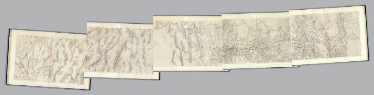
Author
King, Clarence
Full Title
General Sections.
List No
0408.008
Note
In full color. Ten sections shown with the legends on either side of the cross sections.
Author
King, Clarence
Full Title
(Composite of) Topographical Maps I-V, 40th Parallel Survey.
List No
0408.014
Note
Maps in brown shaded relief.
Author
Johnson, A.J.
Full Title
Johnson's California, With Utah, Nevada, Colorado, New Mexico And Arizona Published By Johnson and Ward.
List No
0535.041
Note
In full color. Various routes shown: Proposed Central Pacific Railroad, Proposed Union Pacific Railroad, Pacific Railroad, Pony Express, Emigrant Road, Simpson 1859, Fremont 1845, Fremont 1844, Fremont 1843, Spanish Trail from Los Angeles to Albiguia New Mexico, Spainish Trail from Salt Lake to Santa Fe, Captain Gunnison 1855, Captain Sitgreaves 1951, Major Emory 1846, El Paso Waggon (Wagon) Road, Cimarron Route to Fort Leavenworth, Colonel Washington, etc. Delineates various Indian lands. Shows Head of Navigation on the Colorado River at the confluence with the Virgin River. Relief shown by hachures. Meridians Greenwich and Washington D.C.
Author
Mitchell, Samuel Augustus Jr.
Full Title
County map of California (inset maps) 52. Map of the Settlements in the Great Salt Lake Country. Utah. 53. San Francisco Bay and Vicinity. Entered ... 1867 by S. Augustus Mitchell, Jr. ... Pennsylvania.
List No
0579.043
Note
Color map by county. Relief shown by hachures. Prime meridians are Greenwich and Washington, D.C.
Author
[Morse, Charles W., Colby, Charles A.]
Full Title
California. (inset) Utah and Part of New Mexico.
List No
0623.041
Author
[Touring club italiano, Funk & Wagnalls Company.]
Full Title
(Legend to) Stati Uniti, United States of America, California, Nevada, Utah, Arizona. Propr. Artistico-letteraria del T.C.I. Ufficio cartografico del T.C.I. (1929)
List No
1012CS
Note
Explanation to map.
Author
[Touring club italiano, Funk & Wagnalls Company.]
Full Title
Stati Uniti, United States of America, California, Nevada, Utah, Arizona. (with San Francisco, Oakland, Berkeley region). Propr. Artistico-letteraria del T.C.I. Ufficio cartografico del T.C.I. (1929)
List No
1012.075
Note
Color map. Relief shown by hachures and spot heights; depths by isolines. Inset map at 1:250,000 scale.
Author
U.S. General Land Office
Full Title
(Map 15 - California, Nevada, Utah, Idaho).
List No
1071.017
Note
One of the series of adjacent sixteen maps. Mounted on linen. Relief shown in hachures.
Author
Petri, Girolamo
Full Title
Tav. CXXXI. Province ecclesiastiche di Oregon e di S. Francesco, vicariato aplico della Nebraska.
List No
14007.319
Note
Hand-colored, engraved map showing the ecclesiastical provinces of Oregon, San Francisco (California), as well as the apostolic vicariates of Nebraska. Text in delicate script circling land. Accompanied by descriptive text on facing page. In Volume III.
Author
[Weekly Dispatch, Ettling, Theodor, 1823-]
Full Title
California, Utah, Lr. California and New Mexico / drawn & engraved by T. Ettling, 3 Red Lion Square Holborn ; Day & Son Lithrs. to The Queen.
List No
14360.240
Note
Map of California, Utah, New Mexico and Baja California. Shows political boundaries, cities, railways, roads, topography, bodies of water, drainage, coastlines, shoals, islands and the territories of indigenous peoples. Relief shown with hachures. Includes latitudinal and longitudinal lines, as well as two bar scales given in British and geographical miles. Hand-colored lithograph. Map is 42 x 30 cm, on sheet 48 x 33 cm. Plate number handwritten in ink at upper right corner of sheet; "39 Jan/58" in pencil at bottom of sheet. Appears in Vol. II : Foreign.
Author
[Colton, G.W., Fisher, Richard Swainson]
Full Title
Oregon, Washington, California, Utah, and New Mexico. (inset) Vicinity of San Francisco.
List No
1690.121
Note
Relief depicted by hachures.
Full Title
Diurnal barometric curves. Horary curves Georgetown, Col. ... Colorado Springs, Col. ... Green River, Wyo. Terr. ... Los Angeles, Cal. ... Salt Lake City, Utah ... Santa Fe, New Mexico ... U.S. Geographical Surveys West of the 100th Meridian. (1877)
List No
2220.048
Note
Lithographed chart, b&w. Hourly observations taken 1872-1875.
Full Title
Diurnal barometric curves. Horary curves Hughes, Col. ... Labran, Col. ... Camp Independence, Cal. ... Cottonwood Springs, Nev. ... Beaver, Utah ... U.S. Geographical Surveys West of the 100th Meridian. (1877)
List No
2220.049
Note
Lithographed chart, b&w. Hourly observations taken 1871-1873.
Full Title
Diurnal temperature. Beaver, Utah. Camp Independence, Cal. Labran, Col. Hughes, Col. Cottonwood Springs, Nev. U.S. Geographical Surveys West of the 100th Meridian. (1877)
List No
2220.053
Note
Lithographed chart, b&w. Hourly observations taken 1871-1873.
Full Title
Mean differences, wet and dry bulb thermometers. Beaver, Utah. Camp Independence, Cal. Labran, Col. Hughes, Col. Cottonwood Springs, Nev. U.S. Geographical Surveys West of the 100th Meridian. (1877)
List No
2220.056
Note
Lithographed chart, b&w. Hourly observations taken 1871-1873.
Full Title
Diurnal force of vapor. Colorado Springs, Col. Salt Lake City, Utah. Los Angeles, Cal. Santa Fe, New Mex. Georgetown, Col. Green River, Wyo. Terr. U.S. Geographical Surveys West of the 100th Meridian. (1877)
List No
2220.058
Note
Lithographed chart, b&w. Hourly observations taken 1873-1875.
Full Title
Diurnal force of vapor. Beaver, Utah. Cottonwood Springs, Nev. Hughes, Col. Labran, Col. Camp Independence, Cal. U.S. Geographical Surveys West of the 100th Meridian. (1877)
List No
2220.059
Note
Lithographed chart, b&w. Hourly observations taken 1871-1873.
Full Title
(Diurnal) relative humidity. Georgetown, Col. Los Angeles, Cal. Colorado Springs, Col. Salt Lake City, Utah. Santa Fe, New Mex. Green River, Wyo. Terr. U.S. Geographical Surveys West of the 100th Meridian. (1877)
List No
2220.061
Note
Lithographed chart, b&w. Hourly observations taken 1872-1875.
Full Title
Diurnal relative humidity. Camp Independence, Cal. Cottonwood Springs, Nev. Beaver, Utah. Hughes, Col. Labran, Col. U.S. Geographical Surveys West of the 100th Meridian. (1877)
List No
2220.062
Note
Lithographed chart, b&w. Hourly observations taken 1871-1873.
Author
Wheeler, G.M.
Full Title
Atlas Sheet Number 58. Parts Of E. California, S.E. Nevada, N.W. Arizona & S.W. Utah. Atlas Sheet Number 66. Weyss, Herman & Aguirre, Del. Expeditions of 1872 & 1873, Under the Command of 1st. Lieut. Geo. M. Wheeler, Corps of Engineers, U.S. Army. Geological Assistants: G.K. Gilbert, A.R. Marvine and E.E. Howell. U.S. Geographical Surveys West Of The One-Hundredth Meridian.
List No
2738.045
Note
Two partial atlas sheets on one page. In crayon and showing geological formations in tints. Color legend on outside of each map.
Author
Johnson, A.J.
Full Title
Johnson's California, Territories of New Mexico And Utah By Johnson & Browning. No. 47-48.
List No
2905.031
Note
In full color with Utah, Nevada and New Mexico delineated by broad strips of color. Mail steamship routes shown off the California coast. Routes of the explorers such as Fremont, Gunnison, and Whipple are shown. Emigrant Road is marked by a series of crosses.
Author
U.S. War Department, Chief of Engineers
Full Title
Map Of California And Nevada, With Parts Of Utah & Arizona. Prepared in the Office of the Chief Of Engineers U.S.A. 1879.
List No
3360.000
Note
A larger version of a portion of the Freyhold/Warren U.S. of 1879. Wheat mentions this map in the same paragraph as the Freyhold/Warren map but he does not notice that they are from the same map! Wheat calls this map "certainly a major map of this large area..." Issued on thin paper for field use. Paper is watermarked "Crane Co. 1885." Map is without color.
Author
Mitchell, Samuel Augustus
Full Title
A new map of the State of California, the Territories of Oregon & Utah, and the Chief part of New Mexico. Entered ... 1853, by Thomas, Cowperthwait & Co. ... Pennsylvania.
List No
3803.041
Note
Unlike 1852 ed., counties have been added for Oregon and Utah territories and additional counties added in New Mexico and the map has been extended to include more of New Mexico and Missouri Territory; part of Indian Territory shown. Full color. Relief shown by hachures and spot heights. Prime meridians are Greenwich and Washington.
Author
[Central Pacific Railroad Company, Union Pacific Railroad Company]
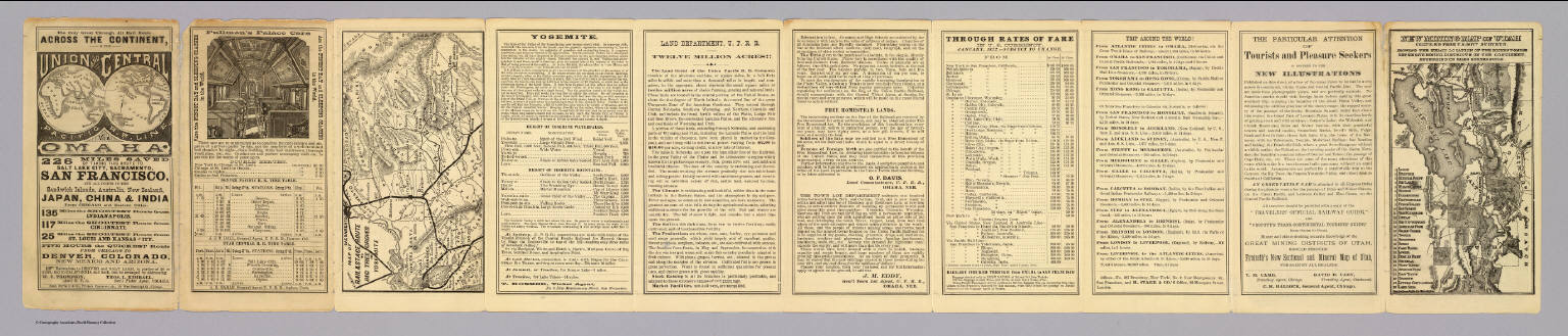
Full Title
(Covers to) The only great through all rail route is the Union and Central Pacific R.R. line via Omaha ... Rand, McNally & Co., Printers Engravers, etc., 108 West Randolph St., Chicago ... Through time table, in effect January 1, 1872.
List No
4107A
Author
[Central Pacific Railroad Company, Union Pacific Railroad Company]
Full Title
(Text Page to) The only great through all rail route is the Union and Central Pacific R.R. line via Omaha ... Rand, McNally & Co., Printers Engravers, etc., 108 West Randolph St., Chicago ... Through time table, in effect January 1, 1872. (with) Map of rail & stage route to Big Tree Groves and Yosemite. (with) New mining map of Utah compiled from U.S. Govt. Surveys ... Nat. Railway Public Co., Philadelphia.
List No
4107.001
Note
10 p. on 1 sheet. Includes tables and text, an ad for Froiseth's new sectional and mineral map of Utah, and 2 maps. Big Tree Groves and Yosemite map at (ca. 1:1,900,000) scale. Utah map at (ca. 1:1,800,000). Relief shown by hachures. Utah map shows mining districts, etc.
Author
[Central Pacific Railroad Company, Union Pacific Railroad Company]
Full Title
(Text Page to) The only great through all rail route is the Union and Central Pacific R.R. line via Omaha ... Rand, McNally & Co., Printers Engravers, etc., 108 West Randolph St., Chicago ... Through time table, in effect January 1, 1872.
List No
4107B
Note
Contains time table and 8 views.
Author
Johnson, A.J.
Full Title
Johnson's California, Utah, Nevada, Colorado, New Mexico, and Arizona. Published by A. J. Johnson, New York. 79. 80. Entered according to the Act of Congress, in the year 1864, by A.J. Johnson in the Clerk's Office of the District Court of the United States for the Southern District of New York.
List No
4574.040
Note
Engraved color map with counties and districts differentiated by color. Shows roads and railroads. Major relief shown by hachures.
Author
[Bancroft, H.H., Knight, W.H.]
Full Title
(Covers to) Bancroft's Map Of California, Nevada, Utah And Arizona. Published By H.H. Bancroft, & Compy. Booksellers & Stationers San Francisco Cal. 1864. Entered ... 1863 by H.H. Bancroft & Company ... California.
List No
4819.001
Note
First edition, first issue of this map. Entered in 1863 and taken from Bancroft's large Map of the Pacific States of 1864, the second edition (first issued in 1863). All of California and Nevada are shown, along with the western parts of Utah and Arizona. A companion map was issued in the same year covering the northern parts of the Pacific States map: Washington, Oregon, Idaho, and Montana. This is the scarcest of the editions of this map. A second issue was published in the same year, with a different border (interlocking leaves as opposed to interlocking Coltonesque metal strips in this copy), with a clean up of various names that were cut off in this first issue along the northern and eastern borders when the plate was extracted from the large map (for instance, "Painted De" for Painted Desert appears at the 35th parallel on the eastern border of Arizona in the first issue and is removed in the second issue) and different labeling of the railroads (see our 4820). To the right of the title the Colton Company name is embossed: G.W. & C.B. Colton & Co. Publishers Of Maps, Atlases, Etc. 172 William Street. N.Y. Map is full color by county and folded into stamped lavender cloth covers 16x10.5 with "Bancroft's Map Of California, Nevada, Utah And Arizona." in gilt. Prime meridians are Greenwich and Washington D.C. Relief shown by hachures.
Author
[Bancroft, H.H., Knight, W.H.]
Full Title
Bancroft's Map Of California, Nevada, Utah And Arizona. Published By H.H. Bancroft, & Compy. Booksellers & Stationers San Francisco Cal. 1864. Entered ... 1863 by H.H. Bancroft & Company ... California.
List No
4819.002
Note
First edition, first issue of this map. Entered in 1863 and taken from Bancroft's large Map of the Pacific States of 1864, the second edition (first issued in 1863). All of California and Nevada are shown, along with the western parts of Utah and Arizona. A companion map was issued in the same year covering the northern parts of the Pacific States map: Washington, Oregon, Idaho, and Montana. This is the scarcest of the editions of this map. A second issue was published in the same year, with a different border (interlocking leaves as opposed to interlocking Coltonesque metal strips in this copy), with a clean up of various names that were cut off in this first issue along the northern and eastern borders when the plate was extracted from the large map (for instance, "Painted De" for Painted Desert appears at the 35th parallel on the eastern border of Arizona in the first issue and is removed in the second issue) and different labeling of the railroads (see our 4820). To the right of the title the Colton Company name is embossed: G.W. & C.B. Colton & Co. Publishers Of Maps, Atlases, Etc. 172 William Street. N.Y. Map is full color by county and folded into stamped lavender cloth covers 16x10.5 with "Bancroft's Map Of California, Nevada, Utah And Arizona." in gilt. Prime meridians are Greenwich and Washington D.C. Relief shown by hachures.
Author
Bancroft, H.H.
Full Title
(Covers to) Bancroft's Map Of California, Nevada, Utah And Arizona. Published By H.H. Bancroft, & Compy. Booksellers & Stationers San Francisco Cal. 1864. Entered ... 1863, by H.H. Bancroft & Company ... California.
List No
4820A
Author
Bancroft, H.H.
Full Title
Bancroft's Map Of California, Nevada, Utah And Arizona. Published By H.H. Bancroft, & Compy. Booksellers & Stationers San Francisco Cal. 1864. Entered ... 1863, by H.H. Bancroft & Company ... California.
List No
4820.001
Note
First edition, second issue of this map with a different border and small changes in the map (see notes to our #4819). Full color by county. Folded into stamped brown cloth covers 16x10.5 with "Bancroft's Map Of California, Nevada, Utah And Arizona." in gilt.
Author
Colton, G.W.
Full Title
Colton's Map of California, Nevada, Utah, Colorado, Arizona & New Mexico. Published by G.W. & C.B. Colton & Co., No. 172 William St. New York.
List No
4825.060
Note
Shows routes, dates of exploration and the explorers. Prime meridians are Washington D.C. and Greenwich. Relief shown by hachures
Author
Johnson, A.J.
Full Title
Johnson's California, Utah, Nevada, Colorado, New Mexico, and Arizona. Published by Alvin J. Johnson & Co., New York. 79. 80. Entered according to the Act of Congress, in the year 1864, by A.J. Johnson in the Clerk's Office of the District Court of the United States for the Southern District of New York.
List No
4828.055
Note
Engraved color map with counties and districts differentiated by color. Shows roads and railroads. Major relief shown by hachures.
Author
Johnson, Alvin Jewett, 1827-1884.
Full Title
Johnson's California, also Utah, Nevada, Colorado, New Mexico and Arizona. Published by Alvin J. Johnson & Son, New York. Entered ... 1864, by A.J. Johnson ... New York. (to accompany) Johnson's New Illustrated Family Atlas Of The World ... MDCCCLXXX (1880).
List No
4830.097
Note
Engraved hand colored in outline map. Shows state and county boundaries, towns, villages, forts, Indian habitation, explorers routes, mining districts, roads, railroads, canals, lakes, mountains and rivers. Relief shown by hachures. Prime meridians are Greenwich and Washington.
Author
Mitchell, Samuel Augustus
Full Title
Map of the State of California, the Territories of Oregon & Utah, and the Chief Part of New Mexico.
List No
4835.047
Note
Unlike 1849 ed., this shows California gold region named and shown in yellow. It also adds basin and range topography in Nevada including Carson and Walker lakes, and the Humboldt River (although in a manner different from the late 1850 and subsequent additions -- they probably drew the topographical changes in quickly, and then corrected them in later editions). Roads colored in red ink. Relief shown by hachures and spot heights. "Oregon" and "Upper or New California" in bold type; all areas shown in full color. Shows Indian tribes and includes descriptive notes. Prime meridians: Greenwich and Washington.
Author
Schonberg & Co.
Full Title
Schonberg's Map of California, Oregon & Nevada with Part of Idaho, Utah & Arizona. Entered ... 1866 .. New York.
List No
5198.004
Note
Counties differentiated by color. Prime meridians Greenwich and Washington D.C. Relief shown by hachures.
|